


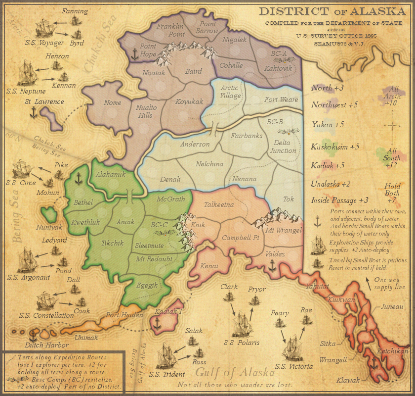
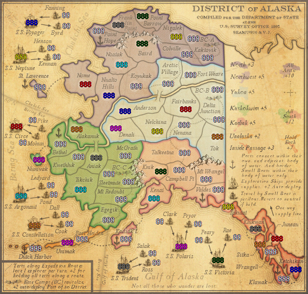
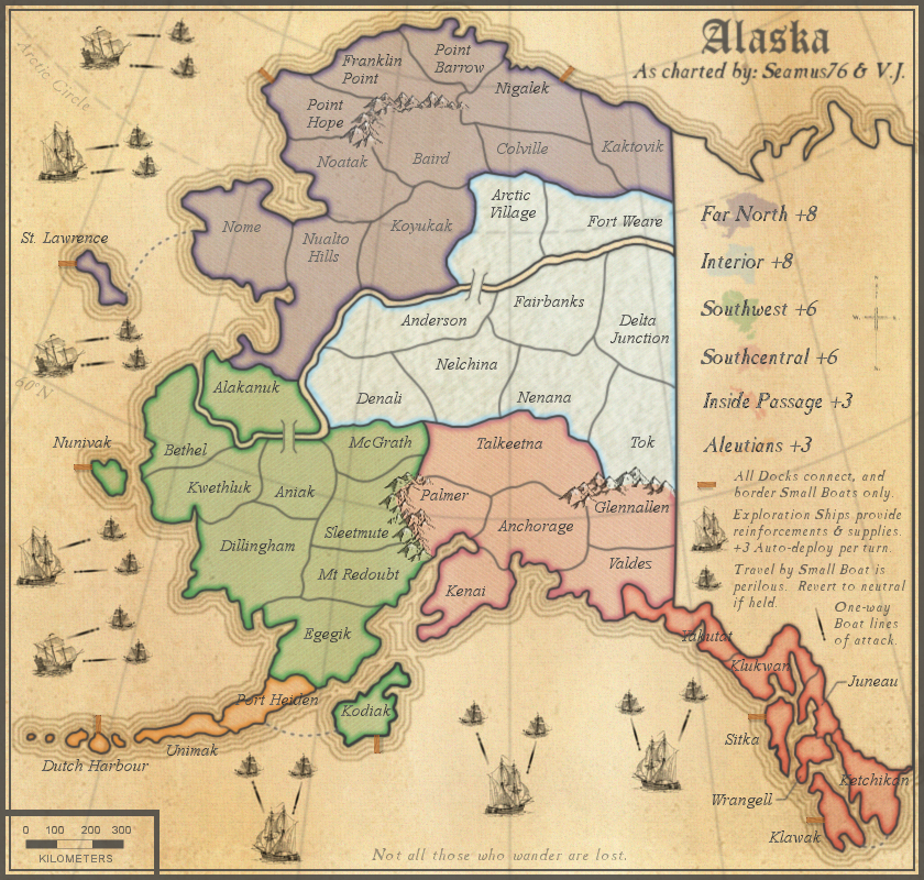
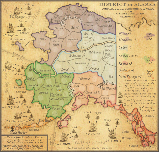
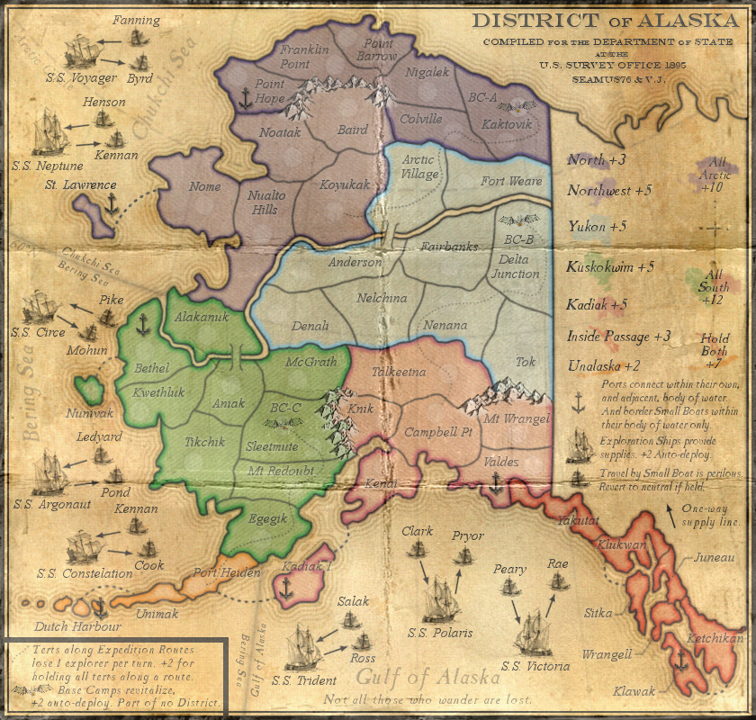
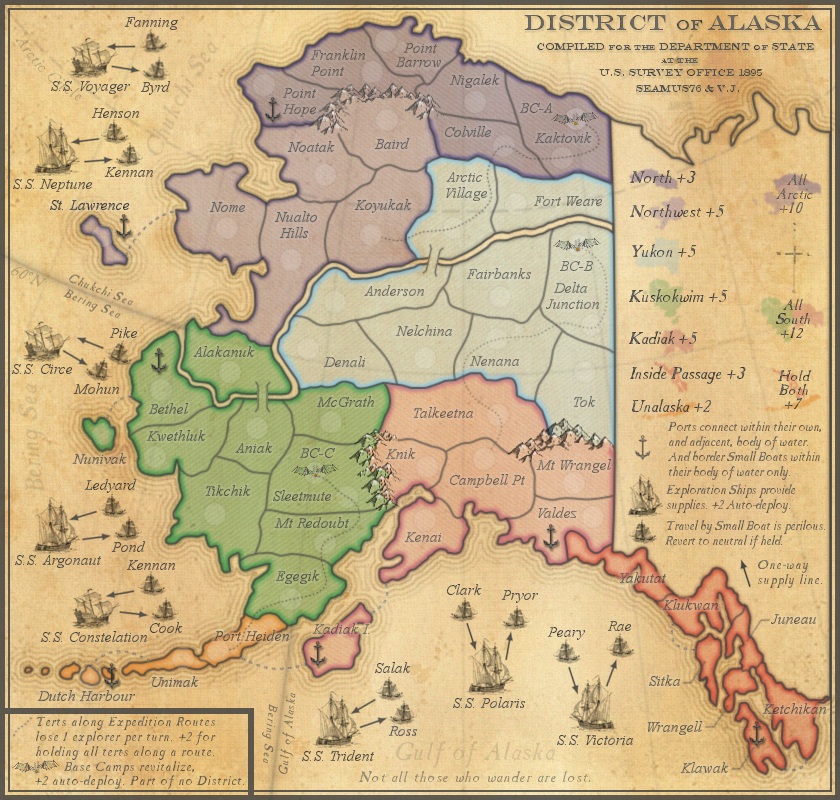
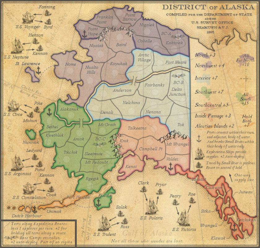
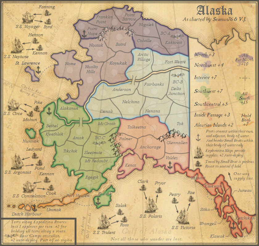
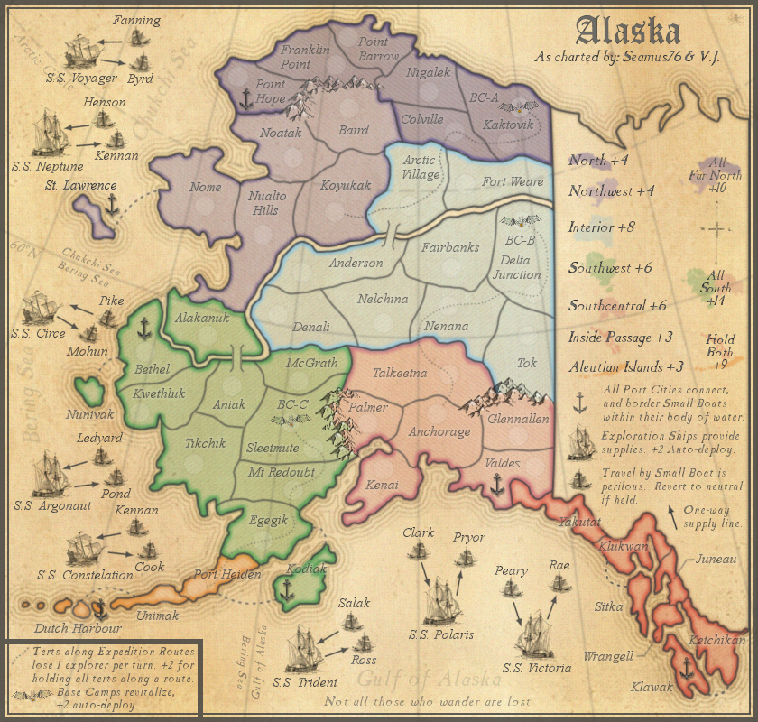
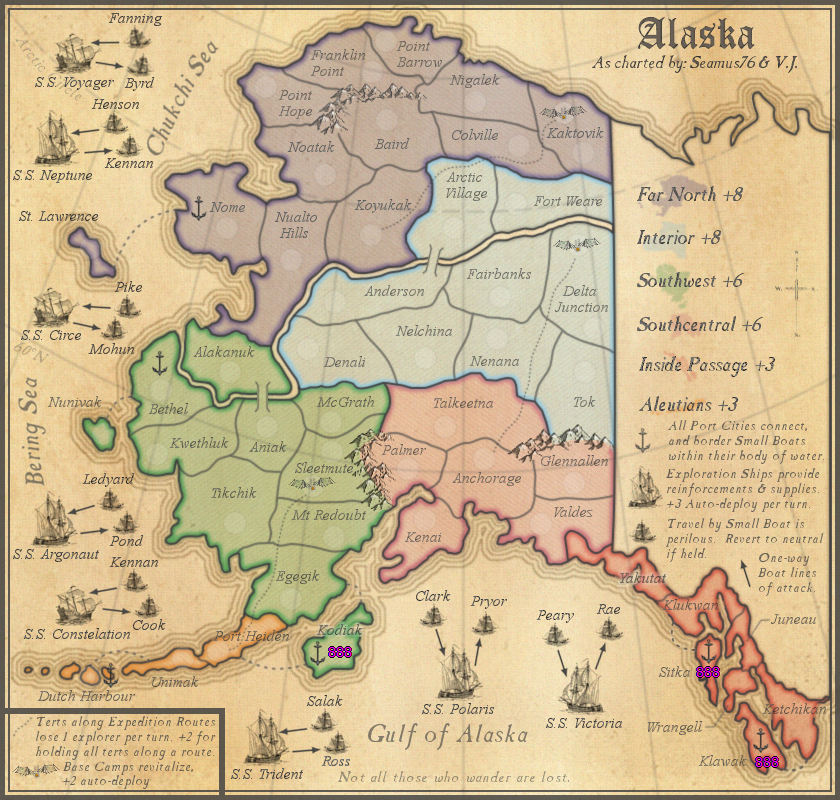
Map Name:Alaska
Mapmaker(s): Seamus76 & V.J.
Number of Territories: 72
Special Features: Too many to name
What Makes This Map Worthy of Being Made: Beautifully crafted, soft graphics with earthy undertones brings players closer than ever before to battling it out in the land of the midnight sun. Auto-deploys, killer neutrals, decays, and Super Region bonuses make this one of the most anticipated maps to come in over a decade.
"The rich graphics bring you in, but it's the gameplay that keeps you coming back." says CC Map Reviewer Mas Sue67
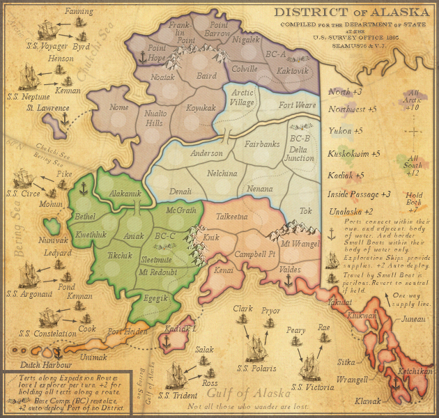
Description: "Not all those who wander are lost."
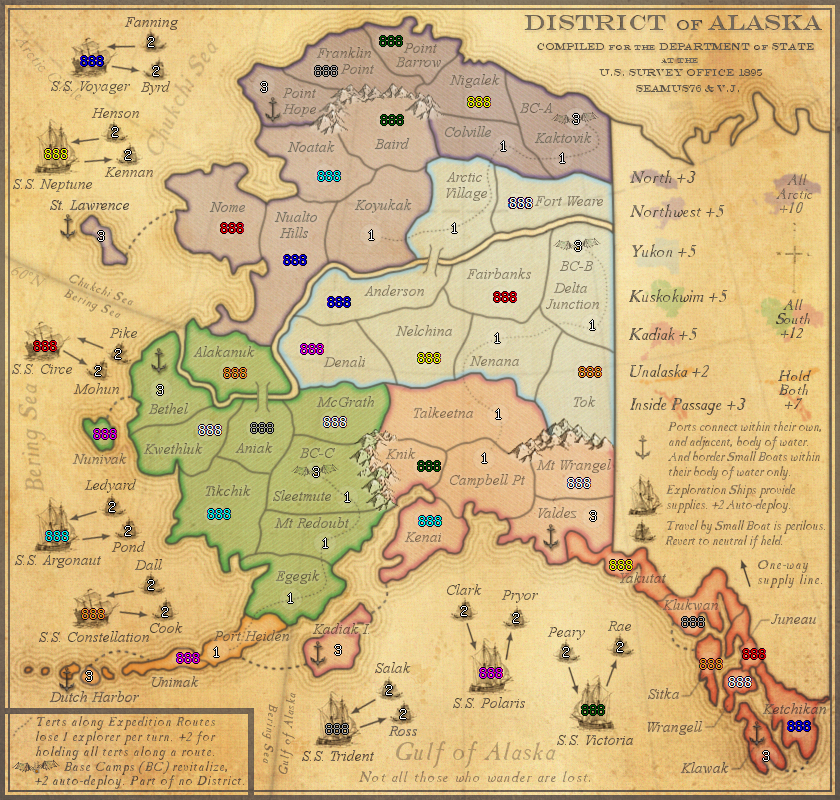
District of Alaska was the designation for Alaska from 1890 through 1912. This map takes place c1895, prior to the Gold Rush, and plays off the arduous task of charting and exploring what some call the Last Frontier. Alaska is also the largest state in the US, and larger than all but 18 Countries in the World.
TERRITORIES
72 territories in total
8 Exploration Ships = +2 auto-deploy
16 Small Boats = Start 2n, and revert to 2n at the top of each turn if held.
7 Ports which are connected to Ports within their own, and adjacent, body of water. They attack, and are attacked by, Small Boats within their body of water only.
Expedition Routes = 12 total terts. Each starts 1n, and loses 1 troop per turn. (Except for Port Heiden, which starts 2n)
BONUSES
Region Bonuses = 7 regions in total (bonuses +2 to +7)
Super Region Bonus = 3 super regions in total (bonuses +7 to +15)
Expedition Route Bonus = +2 for holding all terts along a route (each tert along the route loses 1 troop per turn)
Base Camp Bonus = +2 Auto-deploy (all start 3n)
STARTING POINTS
Currently 37 territories can be starting regions (29 regular terts, and 8 Large Ships).
2p = 11 each = 22 total (9 reg terts plus 2 Large Ships per player)
3p = 11 each = 28 total (9 reg terts plus 2 Large Ships per player)
4p = 8 each = 32 total (7 reg terts plus 1 Large Ship per player)
5p = 6 each = 30 total (5 reg terts plus 1 Large Ship per player)
6p = 5 each = 30 total (4 reg terts plus 1 Large Ship per player)
7p = 5 each = 35 total (4 reg terts plus 1 Large Ship per player)
8p = 4 each = 32 total (3 reg terts plus 1 Large Ship per player)
CURRENT MAP VERSION
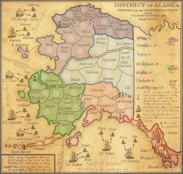
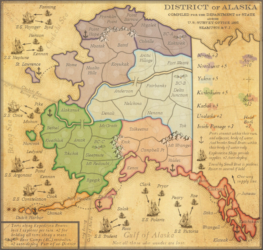
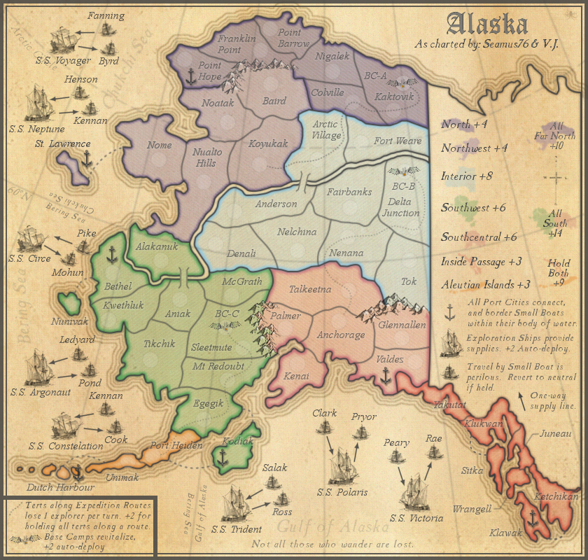
v14.1 - Large (840x800)
- Click image to enlarge.
- Click image to enlarge.
Spoiler
XML update only:
- Changed Sleetmute, Kaktovik, and Delta Junction back to starting 1n instead of 2n, as I had changed in the last update(which to this day has not been uploaded, so I'm not sure much will change to the live map except Port Heiden going to 2n.)
- Updated Constellation spelling
- Changed Sleetmute, Kaktovik, and Delta Junction back to starting 1n instead of 2n, as I had changed in the last update(which to this day has not been uploaded, so I'm not sure much will change to the live map except Port Heiden going to 2n.)
- Updated Constellation spelling
Spoiler
- Click image to enlarge.
Spoiler
- Click image to enlarge.
- Click image to enlarge.
- Click image to enlarge.

Spoiler
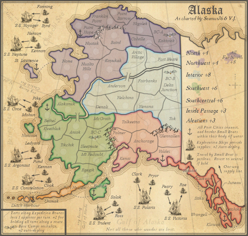
v14.0 - Small (630x600)-with all 888's only http://imageshack.us/a/img36/7055/ue2.png
v14.0 - Large (840x800) http://imageshack.us/a/img545/1826/rs6e.png
v14.0 - Small (630x600) http://imageshack.us/a/img41/503/c365.png
v12.0 - Large (840x800) http://imageshack.us/a/img17/5297/0qjh.png
v12.0 - Small (630x600) http://imageshack.us/a/img845/8595/xlqg.png
v12.0 - Large (840x800)-with 888's and starting neutrals http://imageshack.us/a/img33/3554/69cx.png
v12.0 - Small (630x600)-with 888's and starting neutrals http://imageshack.us/a/img593/5532/6pk7.png
v12.0 - Small (630x600)-with all 888's only http://imageshack.us/a/img62/6557/627l.png
v11.7 - Large (840x800) http://imageshack.us/a/img13/2323/xxm5.png
v11.7 - Small (630x600) http://imageshack.us/a/img835/858/gcju.png
v11.7 - Large (840x800)-with 888's and starting neutrals http://img836.imageshack.us/img836/8012/j49a.png
v11.7 - Small (630x600)-with 888's and starting neutrals http://img42.imageshack.us/img42/5169/9fbf.png
v11.6 - Large (840x800) http://imageshack.us/a/img703/1772/pb5a.png
v11.6 - Small (630x600) http://imageshack.us/a/img849/2957/xb7w.png
v11.5 - Large (840x800) http://imageshack.us/a/img818/4161/e14b.png
v11.5 - Small (630x600) http://imageshack.us/a/img855/7615/0uxd.png
v11.4 - Large (840x800) http://img716.imageshack.us/img716/6224/44uo.png
v11.4 - Small (630x600) http://img96.imageshack.us/img96/2299/vey6.png
v11.4 - Large (840x800)-with 888's and starting neutrals http://img17.imageshack.us/img17/1705/jduk.png
v11.4 - Small (630x600)-with 888's and starting neutrals http://img24.imageshack.us/img24/6011/rx33.png
v11.3 - Large (840x800) http://img4.imageshack.us/img4/4555/b5f7.png
v11.2 - Large (840x800) http://img829.imageshack.us/img829/7084/6qc6.png
v11.1 - Large (840x800) http://img542.imageshack.us/img542/6326/bqw4.png
v11.0 - Large (840x800) http://img713.imageshack.us/img713/2118/w46.png
v10.1 - Large (840x800) http://img600.imageshack.us/img600/4953/38c.png
v10.0 - Large (840x800) http://img855.imageshack.us/img855/3649/dp32.png
v9.2 - Large (840x800) http://img801.imageshack.us/img801/2443/8nw3.png
v9.1 - Large (840x800) http://img824.imageshack.us/img824/7510/3xld.png
v9.0 - Large (840x800) http://img266.imageshack.us/img266/8392/v7r.png
v8.0 - Large (840x800) http://img855.imageshack.us/img855/7918/x7la.png
v7.0 - Large (840x800) http://img856.imageshack.us/img856/77/a ... 40x800.png
v6.5 - Large (840x800) http://img442.imageshack.us/img442/4884 ... 40x800.png
v6.4 - Large (840x800) http://img713.imageshack.us/img713/1520 ... 40x800.png
v6.3 - Large (840x800) http://img541.imageshack.us/img541/8932 ... 40x800.png
v6.2 - Large (840x800) http://img191.imageshack.us/img191/2451 ... 40x800.png
v6.1 - Large (840x800) http://img23.imageshack.us/img23/9778/a ... 40x800.png
v6.0 - Large (840x800) http://img339.imageshack.us/img339/5482 ... 40x800.png
v5.1 - Large (840x800) http://img266.imageshack.us/img266/1658 ... 40x800.png
v5.0 - Large (840x800) http://img835.imageshack.us/img835/6389 ... 40x800.png
v4.0 - Large (840x800) http://img24.imageshack.us/img24/2279/a ... 40x800.png
v3.1 - Large (840x800) http://img443.imageshack.us/img443/9643 ... 40x800.png
v3.0 - Large (840x800) http://img824.imageshack.us/img824/9260 ... 40x800.png
v2.2 - Large (840x800) http://img89.imageshack.us/img89/900/al ... 40x800.png
v2.1 - Large (840x800) http://img541.imageshack.us/img541/462/ ... 40x800.png
v2.0 - Large (840x800) http://img266.imageshack.us/img266/3381 ... 40x800.png
v1.0 - Large (840x800) http://img826.imageshack.us/img826/4616 ... 40x800.png
Spoiler
UPDATE INFO - 2013-12-08:
XML update only:
- Adjusted S.S. Polaris large map coordinate
- Changed Sleetmute, Kaktovik, and Delta Junction to starting 2n instead of 1n
- Changed Port Heiden to starting 2n instead of 1n
UPDATE INFO - 2013-10-21:
After another great talk with Gilligan, thanks buddy, I made a few changes.
- Moved the Chukchi Sea label a little to the right so as not to be covered by the small boat 88's. (large map)
- Moved the Polaris boat set up to allow better overall spacing. (both maps)
I have also updated the XML, (alaska5.xml), and attached it, as well as the updated small map 888 version.
UPDATE INFO - 2013-10-19:
Lots of changes with the finish line in sight. All for the best.
- Updated all of small boat 888's, moving them to the sides, so the boats are visible. (both maps)
- Along those lines I also moved the army circles and 888's off of the Base Camp icons so they are visible as well. (both maps)
- Due to the above changes I needed to redraw the Exploration Routes, and a couple tert borders. (both maps)
- Made a few other minor graphics updates to the small.
This should pretty much fix everything, and show off the small boats and Base Camps. I hope you all like it.
I have also updated the XML, (alaska4.xml), and attached it.
UPDATE INFO - 2013-10-13:
Based on Gilligan's great work finding issues, here are the fixes:
- Point Barrow, Fort Weare, and Franklin Point overlapping names - Fixed (small map)
- Kwethluk, Colville and Knik overlap borders - Fixed (small map)
- Moved St Lawrence and Dutch Harbor anchors (both maps)
- Fixed Constellation misspelling (both maps)
- Changed the duplicate Constellation small boat Kennan to Dall (both maps)
- Rearranged the Sitka army circle and 888 to show the island better (both maps)
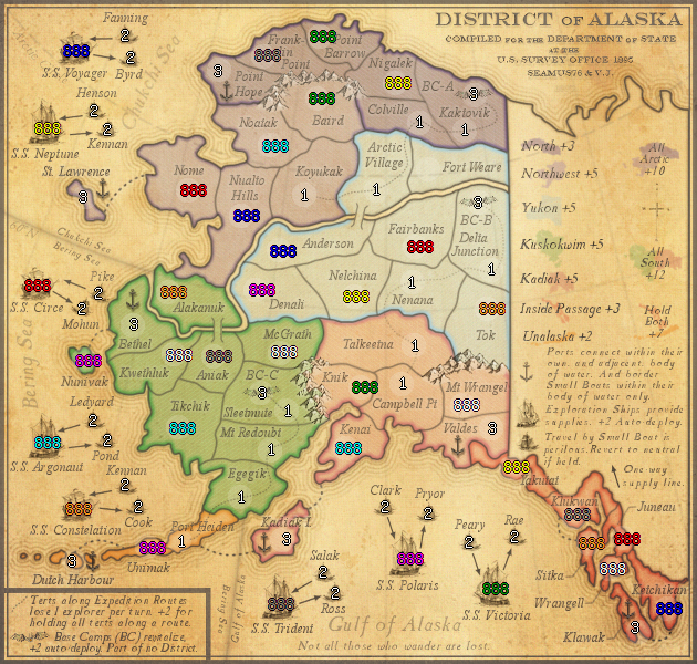
- I also posted all new versions of the small and large with 888's & starting neutrals, and a small version with only 888's to show how the 3 digits look for all terts.
We'll get the xml updated asap.
UPDATE INFO - 2013-09-26:
- The finished XML has been attached, and posted in the Official XML thread. Thanks v.j., and to everyone along the way who helped. We're excited for this one.[
UPDATE INFO - 2013-09-08:
- Updated the 888 army numbers to the new colors. See below.
Also, because the 8 starting Exploration Ships are such a large part of the gameplay this map should be limited to 8 players max.
UPDATE INFO - 2013-09-02:
- When Kadiak Island was moved from Kuskokwim Bonus to Kadiak Bonus, I forgot to update the shapes for the mini maps, so I went ahead and fixed the mini maps for Kuskokwim and Kadiak, as well as the combined "All South".
I also played with the colors of those 3 mini maps a bit, to fix any issues there might be for any CB players, and posted the new CB versions. Personally, I think players, CB or not, will intuitively be able to tell what the "All South" super bonus is, and what two areas it is made up of. But this should take care of any issues.
UPDATE INFO - 2013-08-27:
- Brought out the Sea Route between Nunivak and Bethel, as per Koontz's request. Let me know if this works.
- Fixed some of the text on the small map Base Camp legend info.
UPDATE INFO - 2013-08-25:
- In the legend, per Koontz's suggestion, I swapped positions of the Inside Passage and Unalaska bonus info, and Super Bonus mini-maps. Personally I didn't think players would have a problem, and it looked a little better originally, but I can live with this.
- Changed Dutch Harbour to Dutch Harbor
UPDATE INFO - 2013-08-25:
- Added the Color Blind versions
UPDATE INFO - 2013-08-15:
- Added the regular Small version, and the 888 version. I will post the CB versions tomorrow.
UPDATE INFO - 2013-07-22:
- Removed one of the "antique" overlays and lowered the opacity of the remaining overlay, which made the map less yellow, and the gray objects much darker (i.e. text, sea routes, etc.). I think this works better. It still has the yellow antique feel I wanted, but not so much that it washes it out the map anymore. Thoughts?
- Also lowered the opacity of the white, snowy mountain color to make it a little lest bright, and take it back more to the v7 and v8 look (darker)
- Added the (BC) to the small legend
UPDATE INFO - 2013-07-22(1):
- Fixed any names that might have been hard to read. i.e. Kadiak I.
UPDATE INFO - 2013-07-22:
- Got a little bored so I tried a couple of things to make the map look more antique.
UPDATE INFO - 2013-07-17(1):
Graphics Changes Only:
- Toned down the outer border
- Removed all of the fold marks
- Added a burn hole, thoughts?
UPDATE INFO - 2013-07-17:
Graphics Changes Only:
- Changed the folded paper to be more crisp. (from v10.0, see OLD MAP VERSIONS for difference)
UPDATE INFO - 2013-07-17(#1):
Graphics Changes Only:
- Added the folded paper lines. Played with the levels and mode, etc. Went around and touched up any places where text and a crease met up so as to make the text more legible. I actually think it looks pretty good. Thoughts, too much, just right?
- Added in a light snowy color for the mountains.
UPDATE INFO - 2013-07-06:
Changes:
- Brought out the Sea names a little more.
- Redid the Sea Routes to make them stand out more.
Question:
Starting numbers: Ian, can you please take a look and let me know if these are correct. For the 2 and 3 player games I divided by 3, as per our discussion regarding the game engine assigning out a third to neutral. They look right, but I could be wrong. Thanks.
Other than the starting numbers, which shouldn't effect much, I think the gameplay is pretty much done. Let's get this stamped.
UPDATE INFO - 2013-07-03:
Changes:
- Updated the bonus value of North from +2 to +3
- Updated the bonus value of Yukon from +4 to +5
- Updated the bonus value of Kuskokwim from +4 to +5
- Updated the Super Region Bonuses of All South, and "Hold Both"
- Updated the 888 and Starting Number version, and included below.
Question:
Starting numbers: The 29 starting terts don't take into consideration the Exploration Ships, so 1v1 games start with 14 terts, as you said, but does that include the 2 Exploration Ships? It doesn't look like it does. This then takes the starting terts for 1v1 games to 16 each, which is way too many in my opinion. Am I looking at the numbers correctly? Also, Ian can you let me know your thoughts on all the starting numbers, and what they should be for each game type? Thanks.
Things to work on:
- Make the Sea Routes stand out more.
UPDATE INFO - 2013-06-30:
Thanks for the recent feedback everyone, this version should fix or address most if not all of the comments.
Before I get to the changes, I need to ask about the starting numbers.
Changes:
- Updated all of the Bonus Regions names to fit the time period. (Far North to Arctic, etc.)
- Increased the opacity of the Kadiak, Inside Passage, and Unalaska mini-maps.
- Renamed Kodiak Island to Kadiak Island inline with the time period.
- Moved Kadiak Island from the Kuskokwim region to the Kadiak region.
- Moved Kadiak Island sea route from Egegik to Kenai.
- Added a dark highlight under the Latitude and Longitude lines separating the "Body's of Water", to help players distinguish them more easily.
- Decreased the opacity of all other Latitude and Longitude lines, so they are less distracting.
- In the small bottom left legend changed Base Camp info from "Part of no region" to "Part of no District".
- Lowered the tert border between McGrath and Sleetmute to cut Sleetmute off from Talkeetna.
Things to work on:
- Make the Sea Routes stand out more.
UPDATE INFO - 2013-06-20:
Ok, I've been looking at this for a while now, and even tried changing the Aleutian Islands to lighter(and even darker) shade of green to see if I could replicate how well the Far North worked out, but it just did not look right, and totally threw off the map. So here is what I did do, and then some comments.
- XML question, regarding the 1v1 starting numbers. Is there a way to keep them at 14, and include the Exploration Route terts? Rather than go to 18? I don't like that at all, way too many.
- Tert Names. Koontz and I talked about them early on but I was a little lazy in updating them. Did a ton of research, and using multiple maps from 1867 through 1895 I have updated all of the territory names to be in line with the date of the map. So there were 3-4 terts that have been updated including Anchorage which is gone.
- The other somewhat major thing is the renaming of the map to District of Alaska, which in 1895 was the official Governmental designation for the state.
So, the more I look at the map, the more I think everything works very well, from the old time look and feel, to the more modern and relatable bonus regions and names. I also think the combined Aleutian Island/Inside Passage Super Region bonus makes sense. From an eye perspective, they are the on each side of the map and are the two smaller regions which go nicely together, from a game play perspective they might be the most attractive Super Region bonus on the map. It also fills out the bonus legend very well.
Speaking of the Aleutian Island bonus, as we bounced around, would it make you feel better if it was only a +1 rather than +2? Keep in mind I'm going off the number Koontz ran over a couple of days so I'm really not too sure they should, or need to, actually be changed.
UPDATE INFO - 2013-06-04:
Thanks for the feedback guys. I'm trying to address everything as I go. Here are some of the main requested changes.
- Updated the Port text in the Legend to "Ports connect within their own, and adjacent, body of water. And border Small Boats within their body of water only." Thoughts?
- Due to the above I had to shorten the space between the letters for the Port and Ship text. Things are looking a little cramped over there.
- Added some grunge effects to make the map more antique-ish.
- Added more mountains to cut Baird off from Nigalek.
- Added a 1px white dot to all of the Sea Routes to help bring them out a bit more. Not sure it worked, but if not, I have one other option that will help, which is to go back and stroke them without applying a Gblur, which will make them sharper and maybe easier to see.
How do the starting numbers look?
I'll leave this in from last time...Other than that I'm not sure what else I can do on this one. Personally I really like the game play, especially how the Ship sets work. One question I do have is regarding the Base Camps. Currently they are +2 auto-deploy, but at the same time are on the Expedition Route, and will therefore lose 1 troop. Does that happen before or after the auto-deploy, and with that in mind does the +2 still work? Thanks.
UPDATE INFO - 2013-05-30:
- Updated all of the Region and Super Region bonuses according to Koontz's calculations, which I could find no fault with.
- Added in "Part of no region", for the Base Camps (bottom left legend). I hope that works.
- Spaced out the "+" sign for the Super Region bonus numbers in the large legend.
How do the starting numbers look?
I'll leave this in from last time...Other than that I'm not sure what else I can do on this one. Personally I really like the game play, especially how the Ship sets work. One question I do have is regarding the Base Camps. Currently they are +2 auto-deploy, but at the same time are on the Expedition Route, and will therefore lose 1 troop. Does that happen before or after the auto-deploy, and with that in mind does the +2 still work? Thanks.
UPDATE INFO - 2013-05-28:
- Added the 888 and Starting Neutrals to the OP and the version below.
- With adding the 888's I had to move a couple of things around and make a few small changes.
Things to do:
- Finalize bonuses for North and Northwest regions.
Other than that I'm not sure what else I can do on this one. Personally I really like the game play, especially how the Ship sets work. One question I do have is regarding the Base Camps. Currently they are +2 auto-deploy, but at the same time are on the Expedition Route, and will therefore lose 1 troop. Does that happen before or after the auto-deploy, and with that in mind does the +2 still work? Thanks.
UPDATE INFO - 2013-05-21:
- Flipped the Chukchi Sea text right side up. (60 degree line)
- Redid the rings, decreasing opacity as they leave the shore, as per ManB's suggestion. Thanks, and let me know if you think any need adjustment.
- Fixed a couple other small things.
Things to do:
- Finalize starting numbers and post with neutrals version.
- Finalize bonuses for North and Northwest regions.
UPDATE INFO - 2013-05-21:
- Toned down the ship set text and arrows.
- Added the light outer glow to all tert names to help bring them out. (I did not add them to the boat set text).
- Added a light drop shadow to all of the anchors.
UPDATE INFO - 2013-05-17:
- Added in the "All South" and "Inside Passage + Aleutians" super regions.
- To do the above I had to make the other bonus text smaller.
Things to do.
- Tone down ship set text and arrows.
- Add light outer glow to all tert names to help bring them out.
UPDATE INFO - 2013-05-16:
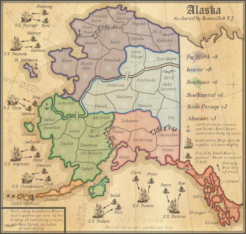
- Broke up the large Far North region as proposed by koontz. The bonus numbers are just place holders. But, I couldn't have the top part called Far North, and the lower Northwest since that is a pretty far departure from the actual "Far North" region. So I kind of went in a best of both worlds direction and broke it up, but added the complete Far North as an additional bonus opportunity. (Which is really just a way to keep the original Far North region represented on the map, which I feel is a must).
- Updated the Large ship info to reflect +2 auto-deploy instead of +3.
- Updated Small boat info in the OP to reflect they will start 2n and revert to 2n if held.
- Changed the legend Arrow description from "attack" to supply line.
- Moved the port from Sitka to Valdez.
Thoughts?
Things to do.
- Tone down ship set text and arrows.
- Add light outer glow to all tert names to help bring them out.
UPDATE INFO - 2013-05-03:
- Moved the 60 degree line up so Bethel would be totally in the Bearing Sea. This involved moving St. Lawrence up a bit.
- Reduced the opacity of the large body of water labels (ex. Bering Sea, etc).
Things to do.
- Tone down ship set text and arrows.
- Fix colors around the mountains.
UPDATE INFO - 2013-05-03:
Thanks for the recent feedback everyone. I had already started down the path of adding the body of water names to the grid lines and rearranging the ship sets. Here's what I did:
- Added body of water names on each side of the separating grid lines. Also added a second layer to make that portion a little darker.
- Moved some of the ship sets around.
- Redid the Expedition Routes to run through the army circles, this meant I had to redo some of the territory lines.
- Added names to each of the Base Camps. My thought was they would be Base Camps Alpha, Bravo, and Charlie.
- Added the port back to Point Hope, and moved the one from Nome back to St Lawrence.
- Removed the reference to "Reinforcements" from the ship legend.
Need thoughts on:
- Bethel Port - Right now the line kind of runs through the top of the tert, does that port need to be moved so people don't think it can be attacked by ships in the Chukchi Sea? It would need to be moved to Nunivak or Kwethluk. Thoughts?
- Ports - Are there enough? (I think so) Are they on the best terts? Etc.
Things to do.
- Tone down ship set text and arrows.
UPDATE INFO - 2013-04-23:
- Changed all of the one way boat lines of attack arrows. They should be clear now.
- Added sea routes from all islands to their bonus region.
- Toned down all of the text to match Colville, as discussed earlier.
- Took some of the border from under the tert names that crossed them, so they stand out more. Also added a white outer glow to some of them to see what they look like.
- Took out the Docks, I tried to do Ports, but they didn't look right, so I went with these Anchors. I like how they look, but now there is an even bigger problem of distinguishing which "body of water" they belong to. If anyone has a good port or a better dock to use, I'd love to take a look. Instead, it might be better to just have all outbound small boats attack all ports, no? Or what's the thought now? For these I included a couple 888's to show how they would go with the anchors.
This is from the last update, and despite the conversations on the topic I would like to continue seeking feedback on these:
- Expedition Routes and Base Camps. What do you all think? The idea is that these expedition routes provide an additional bonus opportunity, and at the same time "break up" the larger bonus regions, by providing bonuses within them, which was a concern for a few people.
--- The Base Camps could use some work, and I'm sure they will change, so I'm more interested in the gameplay behind them. Basically the idea for them is that they provide a resting point for the expedition, which has faced harsh terrain and the loss of 1 explorer per turn.
---- My thought is that the base camp sits within it's tert, and can only be attacked by the tert it's within. Would it be best to leave it the way it is, or have the route go the tert army circle then the base camp army circle, to show the connection?
*See Above As Well for Updated Ports and Thoughts* - I know there have been some comments on this, but I'm looking for some more feedback - As for the docks, and which ship sets they attack, is it clear? Right now it looks like St Lawrence is attacked by both the Bearing Sea ships, and the Chukchi Sea, depending on if the orientation of the dock determines which waters attacks it. (I don't mind it being attacked by both, just wondering.) Or should St Lawrence dock be turned up so that it goes into Chukchi rather than looking like both. This would give those two ship sets two docks, and the 3 in Bearing Sea only 2. Thoughts?
UPDATE INFO - 2013-04-09:
- Added all of the small boat names.
- Redid the title in the same "antique" style as the rest of the text.
- Brought out the Aleutians mini-map image more.
This is from the last update, and despite the conversations on the topic I would like to continue seeking feedback on these:
- Expedition Routes and Base Camps. What do you all think? The idea is that these expedition routes provide an additional bonus opportunity, and at the same time "break up" the larger bonus regions, by providing bonuses within them, which was a concern for a few people.
--- The Base Camps could use some work, and I'm sure they will change, so I'm more interested in the gameplay behind them. Basically the idea for them is that they provide a resting point for the expedition, which has faced harsh terrain and the loss of 1 explorer per turn.
---- My thought is that the base camp sits within it's tert, and can only be attacked by the tert it's within. Would it be best to leave it the way it is, or have the route go the tert army circle then the base camp army circle, to show the connection?
I know there have been some comments on this, but I'm looking for some more feedback - As for the docks, and which ship sets they attack, is it clear? Right now it looks like St Lawrence is attacked by both the Bearing Sea ships, and the Chukchi Sea, depending on if the orientation of the dock determines which waters attacks it. (I don't mind it being attacked by both, just wondering.) Or should St Lawrence dock be turned up so that it goes into Chukchi rather than looking like both. This would give those two ship sets two docks, and the 3 in Bearing Sea only 2. Thoughts?
Things to do (among other things):
- Change the large boat/small boat one-way attack arrows.
- Put a lighter glow behind the tert names to make them stand out more, especially on the smaller islands, etc.
- Add the rest of the general aesthetic stuff.
UPDATE INFO - 2013-03-12:
Thanks again everyone. I'm still trying to process a lot of the feedback recently, but wanted to get this updated gameplay version out for comment.
- The largest update includes the addition of Expedition Routes and Base Camps. What do you all think? The idea is that these expedition routes provide an additional bonus opportunity, and at the same time "break up" the larger bonus regions, by providing bonuses within them, which was a concern for a few people.
--- The other idea behind the Expedition Routes is that as your party moves along them each tert they cross through loses 1 explorer per turn. They can certainly be moved around, but I'd like to keep them between 3-4 terts per route, and I kind of like how a couple of them cross into a different bonus zone.
--- The Base Camps could use some work, and I'm sure they will change, so I'm more interested in the gameplay behind them. Basically the idea for them is that they provide a resting point for the expedition, which has faced harsh terrain and the loss of 1 explorer per turn.
---- My thought is that the base camp sits within it's tert, and can only be attacked by the tert it's within. Would it be best to leave it the way it is, or have the route go the tert army circle then the base camp army circle, to show the connection?
I know there have been some comments on this, but I'm looking for some more feedback - As for the docks, and which ship sets they attack, is it clear? Right now it looks like St Lawrence is attacked by both the Bearing Sea ships, and the Chukchi Sea, depending on if the orientation of the dock determines which waters attacks it. (I don't mind it being attacked by both, just wondering.) Or should St Lawrence dock be turned up so that it goes into Chukchi rather than looking like both. This would give those two ship sets two docks, and the 3 in Bearing Sea only 2. Thoughts?
Things to do (among other things):
- Determine how many neutrals start on the small boats, 1n, 2n, 3n? One thing that might work, and add another wrinkle would be having the small boat that attacks the ship be neutral 3, while the small boat that is attacked by the ship is neutral 1. This would make it harder to use the ship attacking small boat as a card spot or something. Which may not be bad.
- Determine naming convention and add name labels to the Small Boats.
- Work to make all of the "mini-map" images more clear, especially the smaller ones towards the bottom of the region bonus list.
- Put a lighter glow behind the tert names to make them stand out more, especially on the smaller islands, etc.
- Add the rest of the general aesthetic stuff.
UPDATE INFO - 2013-03-12:
- Added names to the large ships. Does anyone have any thoughts on a nice, simple naming convention for the Small Boats? Something that doesn't take up very much room, and wouldn't need additional explanation elsewhere, as space is limited. SB-Nep-1, SB-Nep-2 for the S.S. Neptune Small Boats, maybe?
- Moved some of the ships sets around, as well as the names of the waters.
- I also added some army circles to the Far North just to see what they would look like.
As for the docks, and which ship sets they attack, is it clear? Right now it looks like St Lawrence is attacked by both the Bearing Sea ships, and the Chukchi Sea, depending on if the orientation of the dock determines which waters attacks it. (I don't mind it being attacked by both, just wondering.) Or should St Lawrence dock be turned up so that it goes into Chukchi rather than looking like both. This would give those two ship sets two docks, and the 3 in Bearing Sea only 2. Thoughts?
Things to do (among other things):
- Determine naming convention and add name labels to the Small Boats.
- Work to make all of the "mini-map" images more clear, especially the smaller ones towards the bottom of the region bonus list.
- Put a lighter glow behind the tert names to make them stand out more, especially on the smaller islands, etc.
- In addition to the glow I will be adding army number circles to help indicate where the regions exactly are. (ex. docks, islands, etc.)
- Add the rest of the general aesthetic stuff.
UPDATE INFO - 2013-03-04:
So I added the three bodies of water labels, and changed the Deck legend text to say "All docks connect, and border Small Boats within their bodies of water". Obviously the labels need work, but would labeling the waters and including the text in the legend be enough?
- Removed the dock at Nigalek. One it's in another body of water, and two to help slow down the movement around the map and increase strategic gamepaly.
Things to do (among other things):
- Add name labels to the Exploration Ships and Small Boats.
- Work to make all of the "mini-map" images more clear, especially the smaller ones towards the bottom of the region bonus list.
- Put a lighter glow behind the tert names to make them stand out more, especially on the smaller islands, etc.
- In addition to the glow I will be adding army number circles to help indicate where the regions exactly are. (ex. docks, islands, etc.)
- Add the rest of the general aesthetic stuff.
UPDATE INFO - 2013-03-04:
Thanks everyone for the positive feedback. Here is the second version, which contains a big change/addition to the game play.
- Added Exploration ships, which provide +3 auto-deploy per turn. Each player will start with 1 or 2 depending on the game type. In addition to other territories randomly deployed throughout the map as normal.
- Added Small Boats, which help transport to and from the mainland. Since travel by small boat in these waters is perilous, and risky at best, these small boats revert to 1n at the top of each turn if held.
- The attack arrows indicate the one way attack to and from the Exploration ships.
- Added a little color to the mountains.
Things to do (among other things):
- Add name labels to the Exploration Ships and Small Boats.
- Work to make all of the "mini-map" images more clear, especially the smaller ones towards the bottom of the region bonus list.
- Put a lighter glow behind the tert names to make them stand out more, especially on the smaller islands, etc.
- In addition to the glow I will be adding army number circles to help indicate where the regions exactly are. (ex. ports, islands, etc.)
- Add the rest of the general aesthetic stuff, like ocean labels, etc.
UPDATE INFO - 2013-02-18[/b]:
There is still a lot to do, and I am still working on this but wanted to post the first draft to help iron out some of the gameplay, especially the ships/docks, and the ports.
Things to do (among other things):
- Color mountains. The shapes are what they will be, I just need to color them and delete everything behind them, etc.
- Work to make all of the "mini-map" images more clear, especially the smaller ones towards the bottom of the region bonus list.
- Need new boats. These don't really fit my vision for the theme of the map, but needed a temporary place holder.
- Put a lighter glow behind the tert names to make them stand out more, especially on the smaller islands, etc.
- In addition to the glow I will be adding army number circles to help indicate where the regions exactly are. (ex. ports, islands, etc.)
- Add the rest of the general aesthetic stuff, like ocean labels, etc.
XML update only:
- Adjusted S.S. Polaris large map coordinate
- Changed Sleetmute, Kaktovik, and Delta Junction to starting 2n instead of 1n
- Changed Port Heiden to starting 2n instead of 1n
UPDATE INFO - 2013-10-21:
After another great talk with Gilligan, thanks buddy, I made a few changes.
- Moved the Chukchi Sea label a little to the right so as not to be covered by the small boat 88's. (large map)
- Moved the Polaris boat set up to allow better overall spacing. (both maps)
I have also updated the XML, (alaska5.xml), and attached it, as well as the updated small map 888 version.
UPDATE INFO - 2013-10-19:
Lots of changes with the finish line in sight. All for the best.
- Updated all of small boat 888's, moving them to the sides, so the boats are visible. (both maps)
- Along those lines I also moved the army circles and 888's off of the Base Camp icons so they are visible as well. (both maps)
- Due to the above changes I needed to redraw the Exploration Routes, and a couple tert borders. (both maps)
- Made a few other minor graphics updates to the small.
This should pretty much fix everything, and show off the small boats and Base Camps. I hope you all like it.
I have also updated the XML, (alaska4.xml), and attached it.
UPDATE INFO - 2013-10-13:
Based on Gilligan's great work finding issues, here are the fixes:
- Point Barrow, Fort Weare, and Franklin Point overlapping names - Fixed (small map)
- Kwethluk, Colville and Knik overlap borders - Fixed (small map)
- Moved St Lawrence and Dutch Harbor anchors (both maps)
- Fixed Constellation misspelling (both maps)
- Changed the duplicate Constellation small boat Kennan to Dall (both maps)
- Rearranged the Sitka army circle and 888 to show the island better (both maps)
- I also posted all new versions of the small and large with 888's & starting neutrals, and a small version with only 888's to show how the 3 digits look for all terts.
We'll get the xml updated asap.
UPDATE INFO - 2013-09-26:
- The finished XML has been attached, and posted in the Official XML thread. Thanks v.j., and to everyone along the way who helped. We're excited for this one.[
UPDATE INFO - 2013-09-08:
- Updated the 888 army numbers to the new colors. See below.
Also, because the 8 starting Exploration Ships are such a large part of the gameplay this map should be limited to 8 players max.
UPDATE INFO - 2013-09-02:
- When Kadiak Island was moved from Kuskokwim Bonus to Kadiak Bonus, I forgot to update the shapes for the mini maps, so I went ahead and fixed the mini maps for Kuskokwim and Kadiak, as well as the combined "All South".
I also played with the colors of those 3 mini maps a bit, to fix any issues there might be for any CB players, and posted the new CB versions. Personally, I think players, CB or not, will intuitively be able to tell what the "All South" super bonus is, and what two areas it is made up of. But this should take care of any issues.
UPDATE INFO - 2013-08-27:
- Brought out the Sea Route between Nunivak and Bethel, as per Koontz's request. Let me know if this works.
- Fixed some of the text on the small map Base Camp legend info.
UPDATE INFO - 2013-08-25:
- In the legend, per Koontz's suggestion, I swapped positions of the Inside Passage and Unalaska bonus info, and Super Bonus mini-maps. Personally I didn't think players would have a problem, and it looked a little better originally, but I can live with this.
- Changed Dutch Harbour to Dutch Harbor
UPDATE INFO - 2013-08-25:
- Added the Color Blind versions
UPDATE INFO - 2013-08-15:
- Added the regular Small version, and the 888 version. I will post the CB versions tomorrow.
UPDATE INFO - 2013-07-22:
- Removed one of the "antique" overlays and lowered the opacity of the remaining overlay, which made the map less yellow, and the gray objects much darker (i.e. text, sea routes, etc.). I think this works better. It still has the yellow antique feel I wanted, but not so much that it washes it out the map anymore. Thoughts?
- Also lowered the opacity of the white, snowy mountain color to make it a little lest bright, and take it back more to the v7 and v8 look (darker)
- Added the (BC) to the small legend
UPDATE INFO - 2013-07-22(1):
- Fixed any names that might have been hard to read. i.e. Kadiak I.
UPDATE INFO - 2013-07-22:
- Got a little bored so I tried a couple of things to make the map look more antique.
UPDATE INFO - 2013-07-17(1):
Graphics Changes Only:
- Toned down the outer border
- Removed all of the fold marks
- Added a burn hole, thoughts?
UPDATE INFO - 2013-07-17:
Graphics Changes Only:
- Changed the folded paper to be more crisp. (from v10.0, see OLD MAP VERSIONS for difference)
UPDATE INFO - 2013-07-17(#1):
Graphics Changes Only:
- Added the folded paper lines. Played with the levels and mode, etc. Went around and touched up any places where text and a crease met up so as to make the text more legible. I actually think it looks pretty good. Thoughts, too much, just right?
- Added in a light snowy color for the mountains.
UPDATE INFO - 2013-07-06:
Changes:
- Brought out the Sea names a little more.
- Redid the Sea Routes to make them stand out more.
Question:
Starting numbers: Ian, can you please take a look and let me know if these are correct. For the 2 and 3 player games I divided by 3, as per our discussion regarding the game engine assigning out a third to neutral. They look right, but I could be wrong. Thanks.
Other than the starting numbers, which shouldn't effect much, I think the gameplay is pretty much done. Let's get this stamped.
UPDATE INFO - 2013-07-03:
Changes:
- Updated the bonus value of North from +2 to +3
- Updated the bonus value of Yukon from +4 to +5
- Updated the bonus value of Kuskokwim from +4 to +5
- Updated the Super Region Bonuses of All South, and "Hold Both"
- Updated the 888 and Starting Number version, and included below.
Question:
Starting numbers: The 29 starting terts don't take into consideration the Exploration Ships, so 1v1 games start with 14 terts, as you said, but does that include the 2 Exploration Ships? It doesn't look like it does. This then takes the starting terts for 1v1 games to 16 each, which is way too many in my opinion. Am I looking at the numbers correctly? Also, Ian can you let me know your thoughts on all the starting numbers, and what they should be for each game type? Thanks.
Things to work on:
- Make the Sea Routes stand out more.
UPDATE INFO - 2013-06-30:
Thanks for the recent feedback everyone, this version should fix or address most if not all of the comments.
Before I get to the changes, I need to ask about the starting numbers.
Ian, at first glance this looked great, but when I started adjusting the map with the new neutrals it seems the numbers will now be off. Taking the Exploration Routes out of the starting numbers removes 12 terts, which is a lot. It makes 8 player games start with 3 per player (1 ship and 2 regular terts). Which I'm thinking won't work. Do you have any suggestions?iancanton wrote:u can start all exploration route regions with n1 neutrals to make them easy to conquer, except for base camps being n3. if u do this, then each player in 1v1 will start with 14 regions and no-one will have an unfairly large number of exploration route regions.Seamus76 wrote:- XML question, regarding the 1v1 starting numbers. Is there a way to keep them at 14, and include the Exploration Route terts? Rather than go to 18? I don't like that at all, way too many.
Changes:
- Updated all of the Bonus Regions names to fit the time period. (Far North to Arctic, etc.)
- Increased the opacity of the Kadiak, Inside Passage, and Unalaska mini-maps.
- Renamed Kodiak Island to Kadiak Island inline with the time period.
- Moved Kadiak Island from the Kuskokwim region to the Kadiak region.
- Moved Kadiak Island sea route from Egegik to Kenai.
- Added a dark highlight under the Latitude and Longitude lines separating the "Body's of Water", to help players distinguish them more easily.
- Decreased the opacity of all other Latitude and Longitude lines, so they are less distracting.
- In the small bottom left legend changed Base Camp info from "Part of no region" to "Part of no District".
- Lowered the tert border between McGrath and Sleetmute to cut Sleetmute off from Talkeetna.
Things to work on:
- Make the Sea Routes stand out more.
UPDATE INFO - 2013-06-20:
Thanks Bruce!!Bruceswar wrote:Just dropping a line to say I really like the look of this map. Keep going!
Ok, I've been looking at this for a while now, and even tried changing the Aleutian Islands to lighter(and even darker) shade of green to see if I could replicate how well the Far North worked out, but it just did not look right, and totally threw off the map. So here is what I did do, and then some comments.
- XML question, regarding the 1v1 starting numbers. Is there a way to keep them at 14, and include the Exploration Route terts? Rather than go to 18? I don't like that at all, way too many.
- Tert Names. Koontz and I talked about them early on but I was a little lazy in updating them. Did a ton of research, and using multiple maps from 1867 through 1895 I have updated all of the territory names to be in line with the date of the map. So there were 3-4 terts that have been updated including Anchorage which is gone.
- The other somewhat major thing is the renaming of the map to District of Alaska, which in 1895 was the official Governmental designation for the state.
So, the more I look at the map, the more I think everything works very well, from the old time look and feel, to the more modern and relatable bonus regions and names. I also think the combined Aleutian Island/Inside Passage Super Region bonus makes sense. From an eye perspective, they are the on each side of the map and are the two smaller regions which go nicely together, from a game play perspective they might be the most attractive Super Region bonus on the map. It also fills out the bonus legend very well.
Speaking of the Aleutian Island bonus, as we bounced around, would it make you feel better if it was only a +1 rather than +2? Keep in mind I'm going off the number Koontz ran over a couple of days so I'm really not too sure they should, or need to, actually be changed.
UPDATE INFO - 2013-06-04:
Thanks for the feedback guys. I'm trying to address everything as I go. Here are some of the main requested changes.
- Updated the Port text in the Legend to "Ports connect within their own, and adjacent, body of water. And border Small Boats within their body of water only." Thoughts?
- Due to the above I had to shorten the space between the letters for the Port and Ship text. Things are looking a little cramped over there.
- Added some grunge effects to make the map more antique-ish.
- Added more mountains to cut Baird off from Nigalek.
- Added a 1px white dot to all of the Sea Routes to help bring them out a bit more. Not sure it worked, but if not, I have one other option that will help, which is to go back and stroke them without applying a Gblur, which will make them sharper and maybe easier to see.
How do the starting numbers look?
I'll leave this in from last time...Other than that I'm not sure what else I can do on this one. Personally I really like the game play, especially how the Ship sets work. One question I do have is regarding the Base Camps. Currently they are +2 auto-deploy, but at the same time are on the Expedition Route, and will therefore lose 1 troop. Does that happen before or after the auto-deploy, and with that in mind does the +2 still work? Thanks.
UPDATE INFO - 2013-05-30:
- Updated all of the Region and Super Region bonuses according to Koontz's calculations, which I could find no fault with.
- Added in "Part of no region", for the Base Camps (bottom left legend). I hope that works.
- Spaced out the "+" sign for the Super Region bonus numbers in the large legend.
How do the starting numbers look?
I'll leave this in from last time...Other than that I'm not sure what else I can do on this one. Personally I really like the game play, especially how the Ship sets work. One question I do have is regarding the Base Camps. Currently they are +2 auto-deploy, but at the same time are on the Expedition Route, and will therefore lose 1 troop. Does that happen before or after the auto-deploy, and with that in mind does the +2 still work? Thanks.
UPDATE INFO - 2013-05-28:
- Added the 888 and Starting Neutrals to the OP and the version below.
- With adding the 888's I had to move a couple of things around and make a few small changes.
Things to do:
- Finalize bonuses for North and Northwest regions.
Other than that I'm not sure what else I can do on this one. Personally I really like the game play, especially how the Ship sets work. One question I do have is regarding the Base Camps. Currently they are +2 auto-deploy, but at the same time are on the Expedition Route, and will therefore lose 1 troop. Does that happen before or after the auto-deploy, and with that in mind does the +2 still work? Thanks.
UPDATE INFO - 2013-05-21:
- Flipped the Chukchi Sea text right side up. (60 degree line)
- Redid the rings, decreasing opacity as they leave the shore, as per ManB's suggestion. Thanks, and let me know if you think any need adjustment.
- Fixed a couple other small things.
Things to do:
- Finalize starting numbers and post with neutrals version.
- Finalize bonuses for North and Northwest regions.
UPDATE INFO - 2013-05-21:
- Toned down the ship set text and arrows.
- Added the light outer glow to all tert names to help bring them out. (I did not add them to the boat set text).
- Added a light drop shadow to all of the anchors.
UPDATE INFO - 2013-05-17:
- Added in the "All South" and "Inside Passage + Aleutians" super regions.
- To do the above I had to make the other bonus text smaller.
Things to do.
- Tone down ship set text and arrows.
- Add light outer glow to all tert names to help bring them out.
UPDATE INFO - 2013-05-16:
- Broke up the large Far North region as proposed by koontz. The bonus numbers are just place holders. But, I couldn't have the top part called Far North, and the lower Northwest since that is a pretty far departure from the actual "Far North" region. So I kind of went in a best of both worlds direction and broke it up, but added the complete Far North as an additional bonus opportunity. (Which is really just a way to keep the original Far North region represented on the map, which I feel is a must).
- Updated the Large ship info to reflect +2 auto-deploy instead of +3.
- Updated Small boat info in the OP to reflect they will start 2n and revert to 2n if held.
- Changed the legend Arrow description from "attack" to supply line.
- Moved the port from Sitka to Valdez.
Thoughts?
Things to do.
- Tone down ship set text and arrows.
- Add light outer glow to all tert names to help bring them out.
UPDATE INFO - 2013-05-03:
- Moved the 60 degree line up so Bethel would be totally in the Bearing Sea. This involved moving St. Lawrence up a bit.
- Reduced the opacity of the large body of water labels (ex. Bering Sea, etc).
Things to do.
- Tone down ship set text and arrows.
- Fix colors around the mountains.
UPDATE INFO - 2013-05-03:
Thanks for the recent feedback everyone. I had already started down the path of adding the body of water names to the grid lines and rearranging the ship sets. Here's what I did:
- Added body of water names on each side of the separating grid lines. Also added a second layer to make that portion a little darker.
- Moved some of the ship sets around.
- Redid the Expedition Routes to run through the army circles, this meant I had to redo some of the territory lines.
- Added names to each of the Base Camps. My thought was they would be Base Camps Alpha, Bravo, and Charlie.
- Added the port back to Point Hope, and moved the one from Nome back to St Lawrence.
- Removed the reference to "Reinforcements" from the ship legend.
Need thoughts on:
- Bethel Port - Right now the line kind of runs through the top of the tert, does that port need to be moved so people don't think it can be attacked by ships in the Chukchi Sea? It would need to be moved to Nunivak or Kwethluk. Thoughts?
- Ports - Are there enough? (I think so) Are they on the best terts? Etc.
Things to do.
- Tone down ship set text and arrows.
UPDATE INFO - 2013-04-23:
- Changed all of the one way boat lines of attack arrows. They should be clear now.
- Added sea routes from all islands to their bonus region.
- Toned down all of the text to match Colville, as discussed earlier.
- Took some of the border from under the tert names that crossed them, so they stand out more. Also added a white outer glow to some of them to see what they look like.
- Took out the Docks, I tried to do Ports, but they didn't look right, so I went with these Anchors. I like how they look, but now there is an even bigger problem of distinguishing which "body of water" they belong to. If anyone has a good port or a better dock to use, I'd love to take a look. Instead, it might be better to just have all outbound small boats attack all ports, no? Or what's the thought now? For these I included a couple 888's to show how they would go with the anchors.
This is from the last update, and despite the conversations on the topic I would like to continue seeking feedback on these:
- Expedition Routes and Base Camps. What do you all think? The idea is that these expedition routes provide an additional bonus opportunity, and at the same time "break up" the larger bonus regions, by providing bonuses within them, which was a concern for a few people.
--- The Base Camps could use some work, and I'm sure they will change, so I'm more interested in the gameplay behind them. Basically the idea for them is that they provide a resting point for the expedition, which has faced harsh terrain and the loss of 1 explorer per turn.
---- My thought is that the base camp sits within it's tert, and can only be attacked by the tert it's within. Would it be best to leave it the way it is, or have the route go the tert army circle then the base camp army circle, to show the connection?
*See Above As Well for Updated Ports and Thoughts* - I know there have been some comments on this, but I'm looking for some more feedback - As for the docks, and which ship sets they attack, is it clear? Right now it looks like St Lawrence is attacked by both the Bearing Sea ships, and the Chukchi Sea, depending on if the orientation of the dock determines which waters attacks it. (I don't mind it being attacked by both, just wondering.) Or should St Lawrence dock be turned up so that it goes into Chukchi rather than looking like both. This would give those two ship sets two docks, and the 3 in Bearing Sea only 2. Thoughts?
UPDATE INFO - 2013-04-09:
- Added all of the small boat names.
- Redid the title in the same "antique" style as the rest of the text.
- Brought out the Aleutians mini-map image more.
This is from the last update, and despite the conversations on the topic I would like to continue seeking feedback on these:
- Expedition Routes and Base Camps. What do you all think? The idea is that these expedition routes provide an additional bonus opportunity, and at the same time "break up" the larger bonus regions, by providing bonuses within them, which was a concern for a few people.
--- The Base Camps could use some work, and I'm sure they will change, so I'm more interested in the gameplay behind them. Basically the idea for them is that they provide a resting point for the expedition, which has faced harsh terrain and the loss of 1 explorer per turn.
---- My thought is that the base camp sits within it's tert, and can only be attacked by the tert it's within. Would it be best to leave it the way it is, or have the route go the tert army circle then the base camp army circle, to show the connection?
I know there have been some comments on this, but I'm looking for some more feedback - As for the docks, and which ship sets they attack, is it clear? Right now it looks like St Lawrence is attacked by both the Bearing Sea ships, and the Chukchi Sea, depending on if the orientation of the dock determines which waters attacks it. (I don't mind it being attacked by both, just wondering.) Or should St Lawrence dock be turned up so that it goes into Chukchi rather than looking like both. This would give those two ship sets two docks, and the 3 in Bearing Sea only 2. Thoughts?
Things to do (among other things):
- Change the large boat/small boat one-way attack arrows.
- Put a lighter glow behind the tert names to make them stand out more, especially on the smaller islands, etc.
- Add the rest of the general aesthetic stuff.
UPDATE INFO - 2013-03-12:
Thanks again everyone. I'm still trying to process a lot of the feedback recently, but wanted to get this updated gameplay version out for comment.
- The largest update includes the addition of Expedition Routes and Base Camps. What do you all think? The idea is that these expedition routes provide an additional bonus opportunity, and at the same time "break up" the larger bonus regions, by providing bonuses within them, which was a concern for a few people.
--- The other idea behind the Expedition Routes is that as your party moves along them each tert they cross through loses 1 explorer per turn. They can certainly be moved around, but I'd like to keep them between 3-4 terts per route, and I kind of like how a couple of them cross into a different bonus zone.
--- The Base Camps could use some work, and I'm sure they will change, so I'm more interested in the gameplay behind them. Basically the idea for them is that they provide a resting point for the expedition, which has faced harsh terrain and the loss of 1 explorer per turn.
---- My thought is that the base camp sits within it's tert, and can only be attacked by the tert it's within. Would it be best to leave it the way it is, or have the route go the tert army circle then the base camp army circle, to show the connection?
I know there have been some comments on this, but I'm looking for some more feedback - As for the docks, and which ship sets they attack, is it clear? Right now it looks like St Lawrence is attacked by both the Bearing Sea ships, and the Chukchi Sea, depending on if the orientation of the dock determines which waters attacks it. (I don't mind it being attacked by both, just wondering.) Or should St Lawrence dock be turned up so that it goes into Chukchi rather than looking like both. This would give those two ship sets two docks, and the 3 in Bearing Sea only 2. Thoughts?
Things to do (among other things):
- Determine how many neutrals start on the small boats, 1n, 2n, 3n? One thing that might work, and add another wrinkle would be having the small boat that attacks the ship be neutral 3, while the small boat that is attacked by the ship is neutral 1. This would make it harder to use the ship attacking small boat as a card spot or something. Which may not be bad.
- Determine naming convention and add name labels to the Small Boats.
- Work to make all of the "mini-map" images more clear, especially the smaller ones towards the bottom of the region bonus list.
- Put a lighter glow behind the tert names to make them stand out more, especially on the smaller islands, etc.
- Add the rest of the general aesthetic stuff.
UPDATE INFO - 2013-03-12:
- Added names to the large ships. Does anyone have any thoughts on a nice, simple naming convention for the Small Boats? Something that doesn't take up very much room, and wouldn't need additional explanation elsewhere, as space is limited. SB-Nep-1, SB-Nep-2 for the S.S. Neptune Small Boats, maybe?
- Moved some of the ships sets around, as well as the names of the waters.
- I also added some army circles to the Far North just to see what they would look like.
As for the docks, and which ship sets they attack, is it clear? Right now it looks like St Lawrence is attacked by both the Bearing Sea ships, and the Chukchi Sea, depending on if the orientation of the dock determines which waters attacks it. (I don't mind it being attacked by both, just wondering.) Or should St Lawrence dock be turned up so that it goes into Chukchi rather than looking like both. This would give those two ship sets two docks, and the 3 in Bearing Sea only 2. Thoughts?
Things to do (among other things):
- Determine naming convention and add name labels to the Small Boats.
- Work to make all of the "mini-map" images more clear, especially the smaller ones towards the bottom of the region bonus list.
- Put a lighter glow behind the tert names to make them stand out more, especially on the smaller islands, etc.
- In addition to the glow I will be adding army number circles to help indicate where the regions exactly are. (ex. docks, islands, etc.)
- Add the rest of the general aesthetic stuff.
UPDATE INFO - 2013-03-04:
So I added the three bodies of water labels, and changed the Deck legend text to say "All docks connect, and border Small Boats within their bodies of water". Obviously the labels need work, but would labeling the waters and including the text in the legend be enough?
- Removed the dock at Nigalek. One it's in another body of water, and two to help slow down the movement around the map and increase strategic gamepaly.
Things to do (among other things):
- Add name labels to the Exploration Ships and Small Boats.
- Work to make all of the "mini-map" images more clear, especially the smaller ones towards the bottom of the region bonus list.
- Put a lighter glow behind the tert names to make them stand out more, especially on the smaller islands, etc.
- In addition to the glow I will be adding army number circles to help indicate where the regions exactly are. (ex. docks, islands, etc.)
- Add the rest of the general aesthetic stuff.
UPDATE INFO - 2013-03-04:
Thanks everyone for the positive feedback. Here is the second version, which contains a big change/addition to the game play.
- Added Exploration ships, which provide +3 auto-deploy per turn. Each player will start with 1 or 2 depending on the game type. In addition to other territories randomly deployed throughout the map as normal.
- Added Small Boats, which help transport to and from the mainland. Since travel by small boat in these waters is perilous, and risky at best, these small boats revert to 1n at the top of each turn if held.
- The attack arrows indicate the one way attack to and from the Exploration ships.
- Added a little color to the mountains.
Things to do (among other things):
- Add name labels to the Exploration Ships and Small Boats.
- Work to make all of the "mini-map" images more clear, especially the smaller ones towards the bottom of the region bonus list.
- Put a lighter glow behind the tert names to make them stand out more, especially on the smaller islands, etc.
- In addition to the glow I will be adding army number circles to help indicate where the regions exactly are. (ex. ports, islands, etc.)
- Add the rest of the general aesthetic stuff, like ocean labels, etc.
UPDATE INFO - 2013-02-18[/b]:
There is still a lot to do, and I am still working on this but wanted to post the first draft to help iron out some of the gameplay, especially the ships/docks, and the ports.
Things to do (among other things):
- Color mountains. The shapes are what they will be, I just need to color them and delete everything behind them, etc.
- Work to make all of the "mini-map" images more clear, especially the smaller ones towards the bottom of the region bonus list.
- Need new boats. These don't really fit my vision for the theme of the map, but needed a temporary place holder.
- Put a lighter glow behind the tert names to make them stand out more, especially on the smaller islands, etc.
- In addition to the glow I will be adding army number circles to help indicate where the regions exactly are. (ex. ports, islands, etc.)
- Add the rest of the general aesthetic stuff, like ocean labels, etc.


