The Texan Wars [Quenched]
Moderator: Cartographers
Forum rules
Please read the Community Guidelines before posting.
Please read the Community Guidelines before posting.


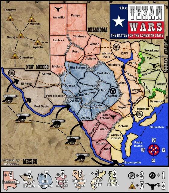
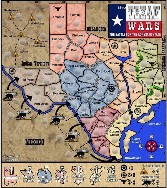
Do these canons look better? Yes the canons act as it's own. I could not find an item that would best describe the Mexican Army. I had idea maybe I could just make land grab areas but I went with canons instead. The time period reflects when mexico tryed taking Texas in days of the Alamo.oaktown wrote:I have two issues with the cannons:
1. I don't get why are there to begin with... you want suggestions for bonus points so I assume they are territories somehow? What are they going to link to?
2. They are very dark - much heavier than everything on the map, which detracts from the overall look.
Map 17
-
WidowMakers
- Posts: 2774
- Joined: Mon Nov 20, 2006 9:25 am
- Gender: Male
- Location: Detroit, MI

-
Incandenza

- Posts: 4949
- Joined: Thu Oct 19, 2006 5:34 pm
- Gender: Male
- Location: Playing Eschaton with a bucket of old tennis balls
It's a nice-looking map thus far.
A few comments:
The RGO territory name looks really cramped.
Lubbock looks like it's in a different font than the other terit names.
I don't get what the brown dashed line is for. If it's an attack route (i.e. you can attack DFW from Houston), you'll need to have that info somewhere in the legend. If not, you can probably lose it.
Speaking of the legend, it seems like there must be a better way to denote the grouped bonuses (longhorn, wagon wheel, and teepee), like "All [wagon wheel] +2."
Do the cannon attack along the big black arrows, or just bombard?
The coloring of central texas and the gulf are awful similar. You've mitigated that somewhat by having the continent outlines in the legend, but it wouldn't hurt to differentiate them a bit more.
The continents in general are going to be tough to hold...
Also, I seem to recall that in the time period you're going for (secession from Mexico), the now-state of Oklahoma was not yet a state and was called the Indian Territory or some such. Also, the Cherokee didn't ever kick it in New Mexico (also not a state at the time).
THOTA: dingdingdingdingdingdingBOOM
Te Occidere Possunt Sed Te Edere Non Possunt Nefas Est
Te Occidere Possunt Sed Te Edere Non Possunt Nefas Est
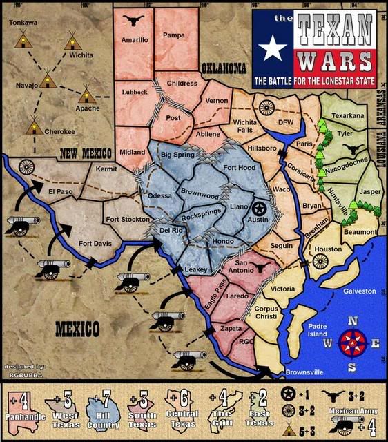
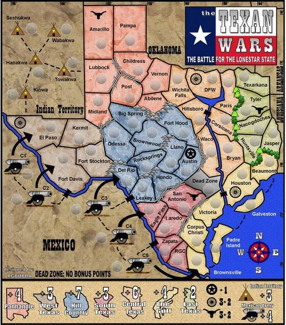
I have decide to take the brown lines off. The wagon wheels are there to get extra points when all are collected.Incandenza wrote:I don't get what the brown dashed line is for. If it's an attack route (i.e. you can attack DFW from Houston), you'll need to have that info somewhere in the legend. If not, you can probably lose it.
Thanks for the update on towns names. I'll take a look in to it.bspride wrote:hey man odessa is really north of midland...also big spring and the territory named odessa are actually on the edwards plateau, not in hill country...and post is definetly not the biggest town in that area
If you would look at the map Odessa is southwest of Midland.
I will change Midland to Plains, it might fit better.
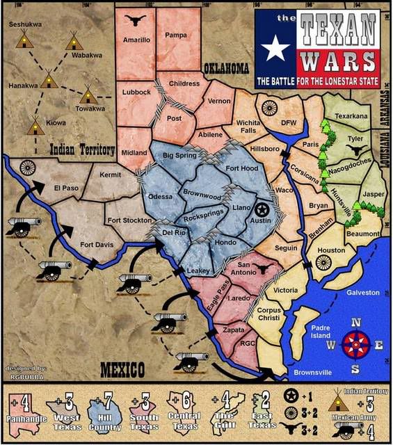
Okay, Andy and I have been debating a bit internally and the main issue keeping your map out of Final Forge is the pixelation/graininess of some things.
I think this may be due to the jpg compression you used. Try to save your working file as a png and then upload it.
If that isn't the case then you are just going to need to fix it manually and keep posting it as a png file from now on.
The problem happens around the black text, Fort Stockton is probably the worst one, if you notice right below it all the excessive graininess.
The icons (cannons and tepees) don't quite look good either due to the jpg compression (at least i hope it is jpg compression, I'd hate to make you redraw everything, but that may be what you are looking at as having to do).
Warning: You may be reading a really old topic.
Thanks for helping me out! I will look in to it after the Holidays!Coleman wrote:Okay, Andy and I have been debating a bit internally and the main issue keeping your map out of Final Forge is the pixelation/graininess of some things.
I think this may be due to the jpg compression you used. Try to save your working file as a png and then upload it.
If that isn't the case then you are just going to need to fix it manually and keep posting it as a png file from now on.
The problem happens around the black text, Fort Stockton is probably the worst one, if you notice right below it all the excessive graininess.
The icons (cannons and tepees) don't quite look good either due to the jpg compression (at least i hope it is jpg compression, I'd hate to make you redraw everything, but that may be what you are looking at as having to do).
-
AndyDufresne

- Posts: 24919
- Joined: Fri Mar 03, 2006 8:22 pm
- Location: A Banana Palm in Zihuatanejo
- Contact:
-
Incandenza
- Posts: 4949
- Joined: Thu Oct 19, 2006 5:34 pm
- Gender: Male
- Location: Playing Eschaton with a bucket of old tennis balls