What is it about hte flags that you dont like thou?wicked wrote:I really don't like the country flags as is. Not sure how to fix it, but I'd rather play the current map than that one (and I've played this map alot).

[Official] British Isles REVAMP [Quenched]
Moderator: Cartographers
Forum rules
Please read the Community Guidelines before posting.
- gimil
- Posts: 8599
- Joined: Sat Mar 03, 2007 12:42 pm
- Gender: Male
- Location: United Kingdom (Scotland)
What do you know about map making, bitch?
Top Score:2403natty_dread wrote:I was wrong
- gimil
- Posts: 8599
- Joined: Sat Mar 03, 2007 12:42 pm
- Gender: Male
- Location: United Kingdom (Scotland)
Ill keep that in mind, they may not be so distractiong with either:wicked wrote:They're too distracting from the countries, and overpower the map. They need to be much much much lighter.
A. Adding army circles
or
B. The army numbers shown covers the map a little.
failing any of these options working ill tweek them again.
What do you know about map making, bitch?
Top Score:2403natty_dread wrote:I was wrong
- gimil
- Posts: 8599
- Joined: Sat Mar 03, 2007 12:42 pm
- Gender: Male
- Location: United Kingdom (Scotland)
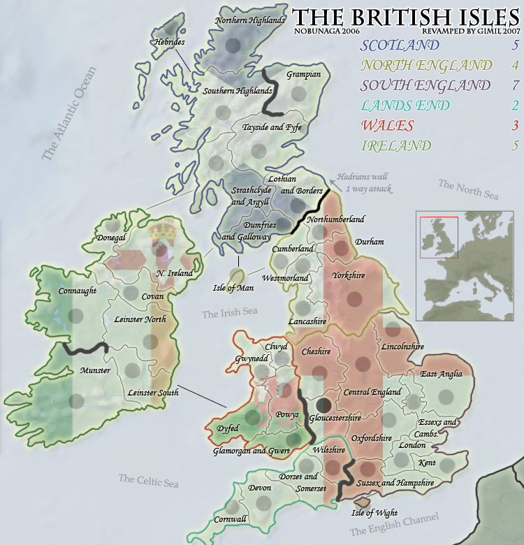
Evidently you are seeing something im not, the terr names and te boarders are solid black, 100% visable. The flags are layered UNDER the boarders. Never the less . . .wicked wrote:no, the army circles won't help. the country lines are so light, as is the text, where the flags seem to be the "top layer" and shouldn't be.
What do you know about map making, bitch?
Top Score:2403natty_dread wrote:I was wrong

No I know it was under, but it didn't SEEM that way since the flags were so "loud" and the territory lines so light. I think that's it, it's too busy. Muting it a bit like you did is a step in the right direction, but I still don't like look of the flags as backgrounds, sorry.
Also, can you do away with the multiple names for the countries?
And why is the Gloucest.. circle so dark?
Also, can you do away with the multiple names for the countries?
And why is the Gloucest.. circle so dark?
- happy2seeyou
- Posts: 4022
- Joined: Mon Jan 22, 2007 2:59 pm
- Gender: Female
- Location: A state that is in the shape of a mitten!
- Contact:
- gimil
- Posts: 8599
- Joined: Sat Mar 03, 2007 12:42 pm
- Gender: Male
- Location: United Kingdom (Scotland)
This is to get realistic geography into the map. THe main reason alot of people asked for a revamp was becasue of the geographical inaccuracy of it. The only way to keep the map moderatly accurate while keeping the exact same gameplay was to merge regions and give mutiply names.wicked wrote: Also, can you do away with the multiple names for the countries?
An accident will fix for the next update.wicked wrote: And why is the Gloucest.. circle so dark?
What do you know about map making, bitch?
Top Score:2403natty_dread wrote:I was wrong
- gimil
- Posts: 8599
- Joined: Sat Mar 03, 2007 12:42 pm
- Gender: Male
- Location: United Kingdom (Scotland)
Yeti_C cares very much for the acuracy of this mapwicked wrote:Who cares about geographical accuracy? Long names are bad enough on maps, two names are horrendous.
I think your exaggerating the name situation. Ill wait for more feedback to see where to take it.
What do you know about map making, bitch?
Top Score:2403natty_dread wrote:I was wrong
- moomaster2000
- Posts: 509
- Joined: Tue Jun 12, 2007 12:19 am
- Location: Encinitas, CA
Not exaggerating at all. As someone's who's played the map a great deal, having two names will be bloody annoying. There's no room for two names in the dropdown menu anyway. I was told in another map thread that sometimes geographical accuracy can be skewed a bit to make the map work. Well the map works as is, don't change the names.gimil wrote:Yeti_C cares very much for the acuracy of this mapwicked wrote:Who cares about geographical accuracy? Long names are bad enough on maps, two names are horrendous.![]()
I think your exaggerating the name situation. Ill wait for more feedback to see where to take it.
- reverend_kyle
- Posts: 9250
- Joined: Tue Mar 21, 2006 4:08 pm
- Location: 1000 post club
- Contact:
- lord voldemort
- Posts: 9596
- Joined: Sat Oct 20, 2007 4:39 am
- Gender: Male
- Location: Launceston, Australia
- Contact:
I think gimil is getting a lot of unnecessary attention here. The original author wants the map redone. If the original author wanted we would have to pull their map from the site, not just redo it. All the maps we get to play on belong to users who let lack use them through an agreement.
We've had complaints about the inaccuracy of British Isles for a long time. The goal of this revamp from my point of view is to improve the graphics and the accuracy of the map.
If you don't want this map redone pm Nobunaga and look at the topic he made : http://www.conquerclub.com/forum/viewtopic.php?t=35358
We've had complaints about the inaccuracy of British Isles for a long time. The goal of this revamp from my point of view is to improve the graphics and the accuracy of the map.
If you don't want this map redone pm Nobunaga and look at the topic he made : http://www.conquerclub.com/forum/viewtopic.php?t=35358
- rebelman
- Posts: 2968
- Joined: Thu Aug 02, 2007 5:24 pm
- Gender: Male
- Location: People's Republic of Cork
- Contact:
I am all for geographic accuracy but the first inaccuracy that needs to be addressed is the map's title The British Isles as for as the Irish Government are concerned those not include the Republic of Ireland
http://en.wikipedia.org/wiki/British_Is ... ng_dispute
The following article outlines how this inaccuracy is being corrected in atlases in Irish schools: (Folens are the main publisher of school books in Ireland)
This geographic region that you are trying to depict more accurately on this map is actually an archipelago of more than 6,000 islands, the two biggest being Great Britain and Ireland. Great Britain, to the east, covers 216,777 km² (83,698 sq. miles), over 2/3 of the total archipelago; Ireland, to the west, covers 84,406 km² (32,589 sq. miles). The other larger islands are situated to the north-west of the archipelago - the Hebrides and Shetland Islands.
The islands that constitute the archipelago include:
Great Britain
Ireland
Northern Isles (including Orkney, Shetland and Fair Isle)
Hebrides (including the Inner Hebrides, Outer Hebrides and Small Isles)
Islands of the lower Firth of Clyde (including the Isle of Arran and Bute)
Anglesey (in Welsh Ynys Môn)
Isles of Scilly
Isle of Wight
Portsmouth Islands (including Portsea Island and Hayling Island)
Islands of Furness
Isle of Portland
Ulster: Arranmore, Tory Island, Rathlin Island
Connacht: Achill Island, Clew Bay islands, Inishturk, Inishbofin, Inishark, Aran Islands
Munster: Blasket Islands, Valentia Island, Cape Clear , Sherkin Island, Great Island
Leinster: Lambay Island, Ireland's Eye
Isle of Man
At EU level the term IONA is used to describe this region - islands of the North Atlantic (if required I can reference the relevant directives in this regard for you)
I am happy to comment further on this but I suspect you get the picture
=====================================
The flag you have in the background for Northern Ireland has not been officially recognised since 1973. This was recently reaffirmed by the NI assembly. It is not the flag of northern Ireland and it creates a new inaccuracy on this map if it is depicted as such.
http://en.wikipedia.org/wiki/Flag_of_Northern_Ireland
=======================================
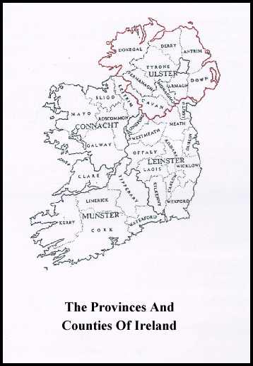
In your map as it is now you have Donegal misspelled. Also if it is your intention to particion the the 9 counties of Ulster in this map to reflect the fact that 6 are under a different administration then you should be aware that there are actually 3 other counties in Ulster you seem to have ommitted Monaghan

=====================================
those big black marker lines need to go prompto
=======================================
i already spke about NI but the flags in general in the background are a no no and should be dropped they add nothing to the map and if anything they take from it and make it far less appealing
========================================
other than those first few initial thoughts, this map is moving along nicely
=====================================
http://en.wikipedia.org/wiki/British_Is ... ng_dispute
The following article outlines how this inaccuracy is being corrected in atlases in Irish schools: (Folens are the main publisher of school books in Ireland)
Ireland exits 'British Isles'
Folens publishers has said it plans to produce a "more correct" version of its widely-used school atlas from January which will omit all references to the "British Isles". The glossy world atlas has a section of 31 pages with maps and information, all of which show Ireland under the heading of the British Isles.
The introduction of the new Folens atlas follows a recent entry on the online encyclopaedia Wikipedia on the term "British Isles" which stated that the phrase could be "confusing and objectionable to some people, particularly in Ireland". The term has in the past been used in a purely geographical sense, to make clear Ireland's proximity to Britain. However, Minister for Foreign Affairs Dermot Ahern has ruled that the term is not used by the Government and is without any official status.
It was made clear by him that the term is not recognised in any legal or inter-governmental sense. It has been suggested in education circles that the Folens atlas highlights the need to have a checking system whereby all textbooks are checked to ensure they conform with the curriculum as outlined by the National Council for Curriculum Assessment.
The Irish Embassy in London has also been urged to monitor the media in Britain for "any abuse of the official terms as set out in the Constitution of Ireland and in legislation". John O'Connor of Folens insisted he had received no complaints from parents regarding the new atlas. The issue had, however, been brought to his attention by a geography teacher.
This geographic region that you are trying to depict more accurately on this map is actually an archipelago of more than 6,000 islands, the two biggest being Great Britain and Ireland. Great Britain, to the east, covers 216,777 km² (83,698 sq. miles), over 2/3 of the total archipelago; Ireland, to the west, covers 84,406 km² (32,589 sq. miles). The other larger islands are situated to the north-west of the archipelago - the Hebrides and Shetland Islands.
The islands that constitute the archipelago include:
Great Britain
Ireland
Northern Isles (including Orkney, Shetland and Fair Isle)
Hebrides (including the Inner Hebrides, Outer Hebrides and Small Isles)
Islands of the lower Firth of Clyde (including the Isle of Arran and Bute)
Anglesey (in Welsh Ynys Môn)
Isles of Scilly
Isle of Wight
Portsmouth Islands (including Portsea Island and Hayling Island)
Islands of Furness
Isle of Portland
Ulster: Arranmore, Tory Island, Rathlin Island
Connacht: Achill Island, Clew Bay islands, Inishturk, Inishbofin, Inishark, Aran Islands
Munster: Blasket Islands, Valentia Island, Cape Clear , Sherkin Island, Great Island
Leinster: Lambay Island, Ireland's Eye
Isle of Man
At EU level the term IONA is used to describe this region - islands of the North Atlantic (if required I can reference the relevant directives in this regard for you)
I am happy to comment further on this but I suspect you get the picture
=====================================
The flag you have in the background for Northern Ireland has not been officially recognised since 1973. This was recently reaffirmed by the NI assembly. It is not the flag of northern Ireland and it creates a new inaccuracy on this map if it is depicted as such.
http://en.wikipedia.org/wiki/Flag_of_Northern_Ireland
=======================================
In your map as it is now you have Donegal misspelled. Also if it is your intention to particion the the 9 counties of Ulster in this map to reflect the fact that 6 are under a different administration then you should be aware that there are actually 3 other counties in Ulster you seem to have ommitted Monaghan

=====================================
those big black marker lines need to go prompto
=======================================
i already spke about NI but the flags in general in the background are a no no and should be dropped they add nothing to the map and if anything they take from it and make it far less appealing
========================================
other than those first few initial thoughts, this map is moving along nicely
=====================================
Don't now why people on here don't like being cooks, remember under siege: A former SEAL, now cook, is the only person who can stop a gang of terrorists when they sieze control of a US Navy battleship.
-
WidowMakers
- Posts: 2774
- Joined: Mon Nov 20, 2006 9:25 am
- Gender: Male
- Location: Detroit, MI
I agree. The flags stand out a little too much. But the map looks great. I think the border color that signifies the continents, needs to be bigger. That couple with a lower opacity of the flags might make it easier to read the map.lord voldemort wrote:make the flags perhaps a lil more seethrough, its also confusing with the north england and south england continent bonus having same flag...
i think the flag background idea is good, but need to be perfected a lil more..cause as people have said, it really does stand out a little bit too much
Keep up the great work.
WM

The problem is of course is that as the old map is - the accuracy is always going to be wrong...gimil wrote:Yeti_C cares very much for the acuracy of this mapwicked wrote:Who cares about geographical accuracy? Long names are bad enough on maps, two names are horrendous.![]()
I think your exaggerating the name situation. Ill wait for more feedback to see where to take it.

If you want to increase the accuracy then you're going to have to move borders...
Your challenge however - is to move the borders and rename but keep the same layout on the map...
C.

Highest score : 2297
I cannot believe I just read thiswicked wrote:Who cares about geographical accuracy?
What if it was your patch of the world? I think you'd feel differently.
If a CC map is representing a real-world place then surely it has a duty to be as accurate as possible.
I know we are only talking about board layouts for an online game, but why mislead when it isn't necessary. Most mapmakers try to go to extraordinary lengths for accuracy (for example the debate about Alaska in the Duck and Cover map) and long may this continue.
gimil - you may have fastposted me last night on page 3 - did you see my suggestion about Central England / W&E Midlands (which is my little part of our planet

the british isles is a geographical term widely used internationally and does not have any political meaning. although most irish people obviously dislike the apparent implication that the british isles belong to the british, calling the map "isles of the north atlantic" fails because this name is not recognised by the vast majority of people. if gimil agrees to change the name, then can anyone find a better alternative than "great britain and ireland"?rebelman wrote:The British Isles as far as the Irish Government are concerned does not include the Republic of Ireland
what other flag can we use? unless someone can think of a suitable one (not the tricolour, unless gimil is a diehard celtic fan), the only logical alternative to keeping all flags is to remove all flags.rebelman wrote:The flag you have in the background for Northern Ireland has not been officially recognised since 1973
ian.
- Karl the Master
- Posts: 25
- Joined: Fri Jan 26, 2007 2:43 pm
- Location: Dublin