Extreme Global Warming [Quenched]
Moderator: Cartographers
Forum rules
Please read the Community Guidelines before posting.
Please read the Community Guidelines before posting.

Going well.
I think it's beyond critique... maybe. It looks good and I'm ready to play on it.
You don't have an income like mine, plus you've never even ridden in my amazing rocket car... Maybe if I get bored I'll bench press it for you.
Click here to get turned into a monster http://s3.bitefight.org/c.php?uid=76785
Click here to get turned into a monster http://s3.bitefight.org/c.php?uid=76785
-
AndyDufresne

- Posts: 24919
- Joined: Fri Mar 03, 2006 8:22 pm
- Location: A Banana Palm in Zihuatanejo
- Contact:

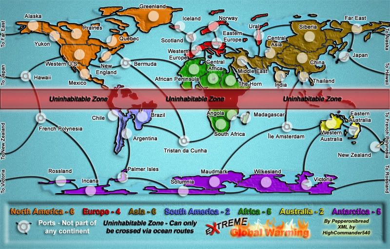
I think he didn't get the fact that you were doing a water elevation effect with that section, where the water isn't near as high over the land there as it is in the ocean so you used a different texture.pepperonibread wrote:What does "cleaned up" mean? I don't see anything wrong with these areas.reverend_kyle wrote:I don't know if this has been mentioned and maybe its too late, but this map needs cleaned up majorly near alaska and greenland, and I'm not a fan of the texture.
I was really hoping Andy's last post was the quench.
Warning: You may be reading a really old topic.
-
pepperonibread

- Posts: 954
- Joined: Sun Jan 28, 2007 4:33 pm
- Location: The Former Confederacy
It's basically perfected...pepperonibread wrote:Yep, me too.Coleman wrote:I was really hoping Andy's last post was the quench.
You don't have an income like mine, plus you've never even ridden in my amazing rocket car... Maybe if I get bored I'll bench press it for you.
Click here to get turned into a monster http://s3.bitefight.org/c.php?uid=76785
Click here to get turned into a monster http://s3.bitefight.org/c.php?uid=76785
-
HighCommander540

- Posts: 24
- Joined: Wed Apr 18, 2007 4:41 pm

-
unriggable

- Posts: 8036
- Joined: Thu Feb 08, 2007 9:49 pm
Re: Going well.
QFTSolus wrote:I think it's beyond critique... maybe. It looks good and I'm ready to play on it.


-
AndyDufresne
- Posts: 24919
- Joined: Fri Mar 03, 2006 8:22 pm
- Location: A Banana Palm in Zihuatanejo
- Contact:
Hm, it's looking nice, and close.
Something I'd see if you can clarify are the SA borders, especially the Argentina and Brazil one...it's small and the border line looks kind of gray and faded. There are a number of other faded spots, so perhaps look around at the other borders as well.
And on the large map, maybe move the Quebec coordinate slightly away from the border near New England. A tad bit more space.
A few of the sea connections don't look like the touch the land, near Brazil is one. There might be a few others. Quick looks there.
But it's looking good.
--Andy
-
pepperonibread
- Posts: 954
- Joined: Sun Jan 28, 2007 4:33 pm
- Location: The Former Confederacy
-
pepperonibread
- Posts: 954
- Joined: Sun Jan 28, 2007 4:33 pm
- Location: The Former Confederacy
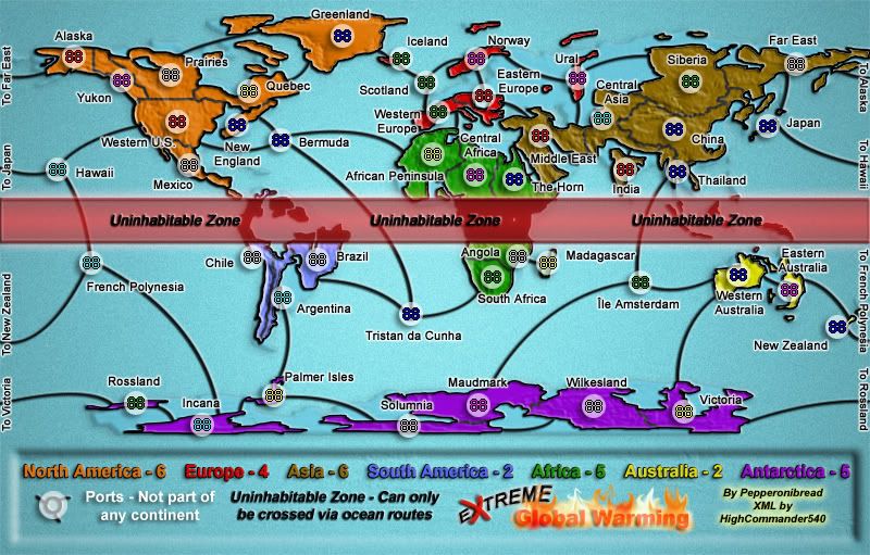
Regarding the sea routes, the bevel of the black continent outlines is just going over them, so they seem to end slightly early. The other stuff will be fixed. Also, I assume this thread means I should update my XML so "territory" replaces "country"?AndyDufresne wrote:Hm, it's looking nice, and close.
Something I'd see if you can clarify are the SA borders, especially the Argentina and Brazil one...it's small and the border line looks kind of gray and faded. There are a number of other faded spots, so perhaps look around at the other borders as well.
And on the large map, maybe move the Quebec coordinate slightly away from the border near New England. A tad bit more space.
A few of the sea connections don't look like the touch the land, near Brazil is one. There might be a few others. Quick looks there.
But it's looking good.
--Andy

-
pepperonibread
- Posts: 954
- Joined: Sun Jan 28, 2007 4:33 pm
- Location: The Former Confederacy
I'll try, but there is also a bevel on the sea routes, so that may overlap the continents. However, I'm going to see what happens if I flatten the bevel so it's no longer a layer effect, then maybe I can erase the part over the sea route.KEYOGI wrote:If that's the case with the sea routes, couldn't you just adjust your layer order to fix the problem?
And yes, the XML will need to be updated with <territory> tags replacing the <country> ones.

-
pepperonibread
- Posts: 954
- Joined: Sun Jan 28, 2007 4:33 pm
- Location: The Former Confederacy

-
pepperonibread
- Posts: 954
- Joined: Sun Jan 28, 2007 4:33 pm
- Location: The Former Confederacy
-
wrightfan123

- Posts: 601
- Joined: Sat Jan 06, 2007 2:58 pm
- Gender: Male
- Location: Looking over every baseball team's schedule to try to determine who will win the World Series.
- Contact: