lol, saw this on the homepage and thought gameplay comments were needed, but seems it's already moved ahead.
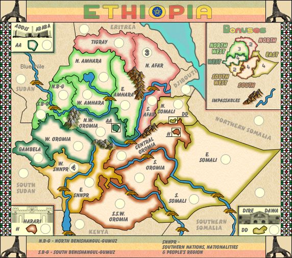
I was just wondering what use the cities had. Thought they'd work as auto-deploys or something, otherwise they're just wasted space?
I also didn't understand why the bonuses with the cities inside them are +4 (since they essentially can only be hit from inside their bonus), while something like North-west which can be broken on all 5 of it's territories, is worth +5?
I had the same question about the +2's but I guess the neutrals provide the equality.
Also, why is 24 terr. a golden number? it gives 1v1 12 terr each?
Graphics then, even tho I don't know much about images.
It took a while to click on the fact that the other countries are playable territories, maybe make that more visible? Could they have their own bonus as well?
Also, could dd move up a bit to be fully enclosed in yellow(N.Somali)? Otherwise it looks like it borders Central Oromia?
SNNPR, could it not all be written on one line or closer together? It seems a bit disconnected right now.
And then, I remember some sort of conspiracy whereby the Ethiopians were blocking the flow of the nile with a dam, could that be incorporated into the image somewhere?
btw, Whats the star in 'O' for Ethiopia; and what are the images in the corners?
[Beta] - Ethiopia [26.8.13] V16 XML Stamped
Moderator: Cartographers
Forum rules
Please read the Community Guidelines before posting.
Please read the Community Guidelines before posting.

Re: Ethiopia: [21.1.13] V08-P5 Gfx Discussion
cities...essentially they are there to make up the numbers of terrsLeehar wrote:lol, saw this on the homepage and thought gameplay comments were needed, but seems it's already moved ahead.
I was just wondering what use the cities had. Thought they'd work as auto-deploys or something, otherwise they're just wasted space?
I also didn't understand why the bonuses with the cities inside them are +4 (since they essentially can only be hit from inside their bonus), while something like North-west which can be broken on all 5 of it's territories, is worth +5?
I had the same question about the +2's but I guess the neutrals provide the equality.
bonuses...these are calcualted from various factors which include number of terrs for a region, borders, number of terrs that can attack etc. please read the guides in tools and guides on bonuses calculations for more info if you're interested.
24 does not give 2 x 12 terr each.Also, why is 24 terr. a golden number? it gives 1v1 12 terr each?
In 1v1 games the number of terrs is split 3 ways between 2 players and the game engine which is why you end up with a lot of neutrals in 1v1 games.
in this case it gives 8 terrs to the players.
Graphics then, even tho I don't know much about images.
even though they have army holders on them?It took a while to click on the fact that the other countries are playable territories,
i think they are visible enough as NOT part of the Ethiopia, and no we have already worked out that they re going to be used as routes around the main country, but don't need their own bonuses.maybe make that more visible? Could they have their own bonus as well?
yes i can do that for you, but as you can see space is very limited there.Also, could dd move up a bit to be fully enclosed in yellow(N.Somali)? Otherwise it looks like it borders Central Oromia?
i will look at re-arranging thoseSNNPR, could it not all be written on one line or closer together? It seems a bit disconnected right now.
No, the gameplay is sorted...on the front page which is where the mapmaker gives a direction for the map....i want it to be kept as a simple small standard gameplay type map.And then, I remember some sort of conspiracy whereby the Ethiopians were blocking the flow of the nile with a dam, could that be incorporated into the image somewhere?
the star....i don't know. Wiki might be your friend there, i simply know that it is part of the flag and i have re-designed it that way for this map with the colours of the flag in the background behind the title.btw, Whats the star in 'O' for Ethiopia; and what are the images in the corners?
the images in the three corners are 3 prominent buildings from those cities. you can find them on wiki if you're more interested....for me they are simply a way to enhance graphics.

* Pearl Harbour * Waterloo * Forbidden City * Jamaica * Pot Mosbi
Re: Ethiopia: [21.1.13] V08-P5 Gfx Discussion
Ok, dd move up and maybe SNPR wording rearrangement.
I'm batting 2 from 8 for my critiquing
I'm batting 2 from 8 for my critiquing
Spoiler
Re: Ethiopia: [21.1.13] V08-P5 Gfx Discussion
Just bumping this to see what i have to do
* Pearl Harbour * Waterloo * Forbidden City * Jamaica * Pot Mosbi
Re: Ethiopia: [21.1.13] V08-P5 Gfx Discussion
I believe that there is a issue that will create a lot of confusion. Its the bridges in whole territories across impassibles. Southern Somalia, Kenya and Sudan. I believe either stopping the rivers all together at the Ethiopian border, or at least dropping those portions of the rivers into the background at a lower opacity. Kenya is the most confusing, I had to look at a true map of Africa to figure out the both sides of the river is Kenya, thus making it adjacent to W. SNNPR.
Couple other question I have.
North and South Somalia are not adjacent, yes? Would be kinda odd if this is true, but if so, making E. Somali go off the map a little more, creating a larger separation between north and south, would make this clearer.
Again I ask about a explanation on the map for what bonuses the cities are in. And along those same lines, do the non-Ethiopian territories constitute a bonus of any kind? If not a explanation that they are part of no bonus should be necessary as well.
Also for consistency, if you name bodies of water, ie, the Blue Nile, you should name them all, or none. Just seems odd to see "Blue Nile" but not Awash River, Red Sea, or Lake T'ana.


Re: Ethiopia: [21.1.13] V09-P5 Gfx Discussion
All that is done RB0.RedBaron0 wrote:I believe that there is a issue that will create a lot of confusion. Its the bridges in whole territories across impassibles. Southern Somalia, Kenya and Sudan. I believe either stopping the rivers all together at the Ethiopian border, or at least dropping those portions of the rivers into the background at a lower opacity. Kenya is the most confusing, I had to look at a true map of Africa to figure out the both sides of the river is Kenya, thus making it adjacent to W. SNNPR.
Couple other question I have.
North and South Somalia are not adjacent, yes? Would be kinda odd if this is true, but if so, making E. Somali go off the map a little more, creating a larger separation between north and south, would make this clearer.
Again I ask about a explanation on the map for what bonuses the cities are in. And along those same lines, do the non-Ethiopian territories constitute a bonus of any kind? If not a explanation that they are part of no bonus should be necessary as well.
Also for consistency, if you name bodies of water, ie, the Blue Nile, you should name them all, or none. Just seems odd to see "Blue Nile" but not Awash River, Red Sea, or Lake T'ana.
Version 9

* Pearl Harbour * Waterloo * Forbidden City * Jamaica * Pot Mosbi
Re: Ethiopia: [16.2.13] V09-P6 Gfx Discussion
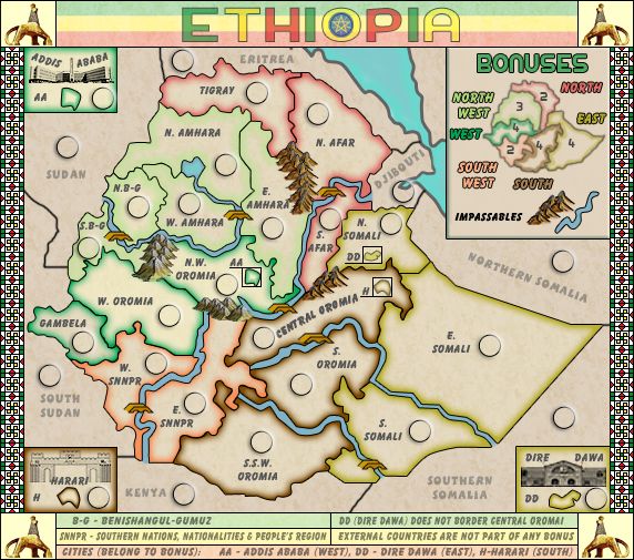
While I see that you have put a disclaimer in the legend that DD doesn't border Central Oromai, I believe it will absolutely cause confusion. Having a territory touching a border, but not actually border it? Your best bet is going to be rearranging stuff in there so DD is completely within N. Somali. Having the territory name, or even the army circle run over a little isn't going to cause the confusion having the little DD box on the border will.
Re: Ethiopia: [16.2.13] V09-P6 Gfx Discussion
I'm going to have to agree with RB0, can you have it the same as Harari? I believe you have the room there to do it.
Re: Ethiopia: [16.2.13] V09-P6 Gfx Discussion
OK, give me a few days to change it...uni on.
* Pearl Harbour * Waterloo * Forbidden City * Jamaica * Pot Mosbi

Re: Ethiopia: [16.2.13] V09-P6 Gfx Discussion
Here are my graphic notes - all constructive, take or leave:
- Saw the star in the 'O' mentioned... I like it. The blue seems too strong for the overall pallette though.
- Nice title font... BUT the 'E' is hard to read because of where the "arms" fall against the tri-color background. You could make the middle tier of the background slightly wider, or a nudge up or down should fix - I know it's vert centered, but the clash is no good.
- "Bonuses" is similarly hard to read... maybe try all caps?
- The patterned border on the sides has the right feel, but it's too loud... I'd suggest dimming it by 20%-40%.
- The Lion of Judah in the corners is a nice touch, and it's the perfect symbol. But the small image you have is hard to "read" as such. Maybe go for a version that's more stylized and easier to recognize at that size.
- The font for the surrounding territories is too light. I know they're not part of Ethiopia, but they are part of the game map, so they should be more immediately visible.
Re: Ethiopia: [26.6.13] V10-P6 Gfx Discussion
I fixed these issues in this new Version 10...i hope to everyone's satisifaction.brhiba wrote:Here are my graphic notes - all constructive, take or leave:
- Saw the star in the 'O' mentioned... I like it. The blue seems too strong for the overall pallette though.
- Nice title font... BUT the 'E' is hard to read because of where the "arms" fall against the tri-color background. You could make the middle tier of the background slightly wider, or a nudge up or down should fix - I know it's vert centered, but the clash is no good.
- "Bonuses" is similarly hard to read... maybe try all caps?
- The patterned border on the sides has the right feel, but it's too loud... I'd suggest dimming it by 20%-40%.
- The Lion of Judah in the corners is a nice touch, and it's the perfect symbol. But the small image you have is hard to "read" as such. Maybe go for a version that's more stylized and easier to recognize at that size.
- The font for the surrounding territories is too light. I know they're not part of Ethiopia, but they are part of the game map, so they should be more immediately visible.
Last edited by cairnswk on Tue Jun 25, 2013 6:47 pm, edited 1 time in total.
* Pearl Harbour * Waterloo * Forbidden City * Jamaica * Pot Mosbi
Re: Ethiopia: [16.2.13] V09-P6 Gfx Discussion
Seems the production of this map has stalled... likely due to rl schooling priorities we all know cairns is up to. This map for the time being will be considered to be on vacation for maximum of 6 months. Should the mapmaker wish to continue this project please contact any CA, once an update is made. Gameplay standards may change between now and when (or if) ever the the project it picked back up. Further gameplay scrutiny may be required upon return to the Foundry, at the discretion of the CA's.
Re: Ethiopia: [26.6.13] V10-P6 Gfx Discussion
cairnswk wrote:I fixed these issues in this new Version 10...i hope to everyone's satisifaction.brhiba wrote:Here are my graphic notes - all constructive, take or leave:
- Saw the star in the 'O' mentioned... I like it. The blue seems too strong for the overall pallette though.
- Nice title font... BUT the 'E' is hard to read because of where the "arms" fall against the tri-color background. You could make the middle tier of the background slightly wider, or a nudge up or down should fix - I know it's vert centered, but the clash is no good.
- "Bonuses" is similarly hard to read... maybe try all caps?
- The patterned border on the sides has the right feel, but it's too loud... I'd suggest dimming it by 20%-40%.
- The Lion of Judah in the corners is a nice touch, and it's the perfect symbol. But the small image you have is hard to "read" as such. Maybe go for a version that's more stylized and easier to recognize at that size.
- The font for the surrounding territories is too light. I know they're not part of Ethiopia, but they are part of the game map, so they should be more immediately visible.
* Pearl Harbour * Waterloo * Forbidden City * Jamaica * Pot Mosbi
Re: Ethiopia: [16.2.13] V09-P6 Gfx Discussion
RedBaron0 wrote:While I see that you have put a disclaimer in the legend that DD doesn't border Central Oromai, I believe it will absolutely cause confusion. Having a territory touching a border, but not actually border it? Your best bet is going to be rearranging stuff in there so DD is completely within N. Somali. Having the territory name, or even the army circle run over a little isn't going to cause the confusion having the little DD box on the border will.
I beieive this has been fixed.isaiah40 wrote:I'm going to have to agree with RB0, can you have it the same as Harari? I believe you have the room there to do it.
An update was done 25 June, yet the map still sits in the Recycling box!RedBaron0 wrote:Seems the production of this map has stalled... likely due to rl schooling priorities we all know cairns is up to. This map for the time being will be considered to be on vacation for maximum of 6 months. Should the mapmaker wish to continue this project please contact any CA, once an update is made. Gameplay standards may change between now and when (or if) ever the the project it picked back up. Further gameplay scrutiny may be required upon return to the Foundry, at the discretion of the CA's.
* Pearl Harbour * Waterloo * Forbidden City * Jamaica * Pot Mosbi

Re: Re: Ethiopia [26.6.13] V10-p6 Gfx Discussion
(Side Note)
I like Labyrinth which is a map in Beta...
At one time it had cups scattered around the map which was called FOOD and if gathered gained a bonus..
(Idea for this map)
You should do something like that as well - add a scatter bonus - maybe toss different types of foods all over the map and if the player gathers all the food - or maybe just gains any food - then they get a bonus of some type..
Just an idea... .
Re: Re: Ethiopia [26.6.13] V10-p6 Gfx Discussion
Aleena wrote:(Side Note)
I like Labyrinth which is a map in Beta...
At one time it had cups scattered around the map which was called FOOD and if gathered gained a bonus..
(Idea for this map)
You should do something like that as well - add a scatter bonus - maybe toss different types of foods all over the map and if the player gathers all the food - or maybe just gains any food - then they get a bonus of some type..
Just an idea... .
Aleena, this url http://www.conquerclub.com/forum/viewto ... 5#p4002301
links to that idea i had some time ago and some people didn't like it...they wanted simple.
Thanks for your idea...at this stage unless there is massive support ( like over 20 players commenting) for putting the food back (in some sort of version) i'll give it a miss.
* Pearl Harbour * Waterloo * Forbidden City * Jamaica * Pot Mosbi
-
koontz1973
- Posts: 6960
- Joined: Thu Jan 01, 2009 10:57 am
Re: Re: Ethiopia [26.6.13] V10-p6 Gfx Discussion
Agreed with cairns, I remember that talk about the scatter bonus, all it added was confusion and delay (too much Thomas the tank engine). This to go back cairns?

Re: Ethiopia: [16.2.13] V09-P6 Gfx Discussion
cairnswk wrote:RedBaron0 wrote:While I see that you have put a disclaimer in the legend that DD doesn't border Central Oromai, I believe it will absolutely cause confusion. Having a territory touching a border, but not actually border it? Your best bet is going to be rearranging stuff in there so DD is completely within N. Somali. Having the territory name, or even the army circle run over a little isn't going to cause the confusion having the little DD box on the border will.I beieive this has been fixed.isaiah40 wrote:I'm going to have to agree with RB0, can you have it the same as Harari? I believe you have the room there to do it.
An update was done 25 June, yet the map still sits in the Recycling box!RedBaron0 wrote:Seems the production of this map has stalled... likely due to rl schooling priorities we all know cairns is up to. This map for the time being will be considered to be on vacation for maximum of 6 months. Should the mapmaker wish to continue this project please contact any CA, once an update is made. Gameplay standards may change between now and when (or if) ever the the project it picked back up. Further gameplay scrutiny may be required upon return to the Foundry, at the discretion of the CA's.
Ah, i think so thanks koontz1973koontz1973 wrote:Agreed with cairns, I remember that talk about the scatter bonus, all it added was confusion and delay (too much Thomas the tank engine). This to go back cairns?
* Pearl Harbour * Waterloo * Forbidden City * Jamaica * Pot Mosbi
-
koontz1973
- Posts: 6960
- Joined: Thu Jan 01, 2009 10:57 am
Re: Re: Ethiopia [26.6.13] V10-p6 Gfx Discussion
Ta muchly koontzkoontz1973 wrote:Here you go cairns.
* Pearl Harbour * Waterloo * Forbidden City * Jamaica * Pot Mosbi
Re: Ethiopia [26.6.13] V10-p6 Gfx Discussion
This was done in Firewroks originally...now moving it over to PS5 
* Pearl Harbour * Waterloo * Forbidden City * Jamaica * Pot Mosbi
Re: Ethiopia [5.7.13] V11(PS)-p7 Gfx Discussion
new photoshop version 11
* Pearl Harbour * Waterloo * Forbidden City * Jamaica * Pot Mosbi

Re: Re: Ethiopia [5.7.13] V11(PS)-p7 Gfx Discussion
Where are the bonus values?
Highest Rank: 26 Highest Score: 3480

Re: Re: Ethiopia [5.7.13] V11(PS)-p7 Gfx Discussion
Bruceswar wrote:Where are the bonus values?
* Pearl Harbour * Waterloo * Forbidden City * Jamaica * Pot Mosbi
Re: Re: Ethiopia [5.7.13] V11(PS)-p7 Gfx Discussion
I also think with a light map like this you do not need army circles? Seems a bit unneeded?
Highest Rank: 26 Highest Score: 3480