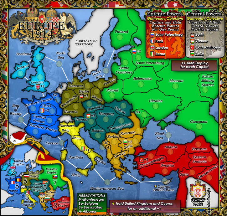
Oneyed...may i make a suggestion...that you include these areas of influence also in your map as a reference point for troop initiations and other battles.
1. If you examine my WWI Ottoman Empire map you'll find that influence for the war encompassed the Arabaian Peninsular and Palestine areas also. This is where the famous story of Lawrence of Arabia comes from.
2. Australian troops for Gallipoli initally came from Egypt, not London.
3. If you read this document
http://www.dva.gov.au/commems_oawg/comm ... _Unit3.pdf
you'll find there were other troops involved in Gallipoli,
There were four main landing forces:
Australian and New Zealand Army Corps (ANZACs)
the British 29th Division
the French Oriental Expeditionary Corps
the Royal Naval Division.
The total number of men to be landed was about 75,000.
These troops came from:
Britain – with Regiments formed in England, Scotland, Ireland
and Wales;
the British Empire – mainly from Australia and New Zealand,
but with troops also from Newfoundland, Ceylon (the English
Planters’ Rifle Corps), India (the Indian Mule Cart Corps),
and Malta;
France and some African colonial troops from Algeria,
Morocco, Senegal; and
Palestine – Russian and Syrian Jewish refugees (the Zion
Mule Corps).
4. The german fleet was not based in Berlin. You could put another territory in near Hamburg at Wilhelmshaven as the German Fllet Base, and call that territory you have in the North Sea the Battle of Jutland which is the major skimish between Britain and Germany in 1916.
Germany had three dockyards: at Kiel and Wilhelmshaven, and a much smaller facility at Danzig. The High Seas Fleet made its home port at Wilhelmshaven, Germany's principal North Sea base, on the Jade Bay near Hamburg.
from
http://www.cityofart.net/bship/deutsch.html#base
5. the English fleet base was based mainly at Plymouth not London.
6. The Russians had a naval fleet operating in the Baltic and Black Sea which are areas that saw combat skirmishes - you haven't mentioned these
7. Spain was neutral in WWI, but lost many tonnes of cargo to the German U-boats. That could be a feature somehow operating in the Altantic Ocean, and give reason to increase the size of the map so that the naval line from England goes properly through the Med. Sea. and not over Spain.
8. the italian campaign seems confined to Northern Italy
http://en.wikipedia.org/wiki/Italian_Ca ... d_War_I%29
in the Eastern Alps and northern Dalmatia.
This piece from
http://en.wikipedia.org/wiki/Italy_in_World_War_I shows that Italy also had problems in Africa.
As Italy entered the war on 23 May 1915, the situation of her forces in the colonies was critical. Italian Somaliland was far from being pacified, and in Cyrenaica the Italian forces were confined to some separated points on the coast. In Tripolitania and Fezzan, the story has a different beginning. In August 1914 the Italian forces reached Ghat, that is, conquered most of western Libya. But in November 1914, this advance turned into a general retreat, and on 7 April and 28 April, they suffered two reverses at Wadi Marsit (near Mizda) and al-Qurdabiya (near Sirte) respectively. By August 1915, the situation in Tripolitania was similar to that of Cyrenaica. The conquest of Libya was not resumed until January 1922.
9. There is no reference on your map to some of these major battles
http://en.wikipedia.org/wiki/List_of_mi ... orld_War_I
that took place.
In short and to be somewhat blunt (but not to offend

)...the map seems like simply another map of Europe with some WWI territories marked on it that you may possibly develop some special gameplay on.
If you really want to create an excellent map for WWI based around Europe, then please include a good majority of these reference battles and then name the map WWI - Europe and (Africa). I realise you can't include everything, but a good majority would be appropriate.
And yes... it would be important to get it supersized.
Please rethink your plans here.


