Extreme Global Warming [Quenched]
Moderator: Cartographers
Forum rules
Please read the Community Guidelines before posting.
Please read the Community Guidelines before posting.
-
Lt. Valerian

- Posts: 36
- Joined: Fri Feb 09, 2007 11:24 am
- Location: United States
-
pepperonibread

- Posts: 954
- Joined: Sun Jan 28, 2007 4:33 pm
- Location: The Former Confederacy
first of all, its not a post-apocalyptic world. this amount of global warming would take place over hundreds of years, so its not like there are gonna be giant tidal waves that flood the coasts. and dont you think humans would EVENTUALLY see the threat and adapt a little? people could build off previously flooded islands so they wouldnt have to make the ports floating or start building off the ocean floor. and these ports wouldnt be huge cities or anything. they would be international ports for ships and aircraft. so, for my map, i took current, centralized islands and turned them into ports. and finally, in response to the comment about moscow being gone, cities like that could be saved, i just didnt see the point in putting a bunch of little major cities off the coast of every continentLt. Valerian wrote:Wait, floating cities? What is this, Water World? Also, who would expend the resources in this post-apocalyptic world to build these things especially in the South Indian Ocean?
and about playability. without the ports, it would just look even more like the classic map. thats actually the reason i put the ports and the uninhabitable zone in, so it would be different from classic

-
pepperonibread
- Posts: 954
- Joined: Sun Jan 28, 2007 4:33 pm
- Location: The Former Confederacy

so i read from multiple sources that even if all the polar ice caps melted that sea levels would rise around 70 meters. your map looks more like a 300 meter rise. so what would make the oceans rise that much besides ice melting?
again a great site to look at... http://merkel.zoneo.net/Topo/Applet/ plug in the amount of sea level rise or fall and it will give you resulting maps for the world, europe, france, se asia, japan and korea, west coast and east coast usa.
again a great site to look at... http://merkel.zoneo.net/Topo/Applet/ plug in the amount of sea level rise or fall and it will give you resulting maps for the world, europe, france, se asia, japan and korea, west coast and east coast usa.
-
fluffybunnykins

- Posts: 385
- Joined: Tue May 02, 2006 6:43 am
- Location: Liverpool, UK
http://flood.firetree.net/
this one uses google map, so you can zoom in & out, pan, view by map, satelite photo or hybrid, etc.
You can only raise by up to 14m, though, so it might not be extreme enough for your use...
I'm still OK, where I live now, even after 14m. But where I used to live is gone in 2! Phew!
this one uses google map, so you can zoom in & out, pan, view by map, satelite photo or hybrid, etc.
You can only raise by up to 14m, though, so it might not be extreme enough for your use...
I'm still OK, where I live now, even after 14m. But where I used to live is gone in 2! Phew!
Superman wears 'Fluffybunnykins' pyjamas

Who said this map is not original - looks pretty original to me...
Obviously, this is going to take work but the foundations are there for a great map!
(Damn - if this were to happen anytime soon in real life I will be fucked! Northern Ireland has gone!
  )
)
Obviously, this is going to take work but the foundations are there for a great map!
(Damn - if this were to happen anytime soon in real life I will be fucked!
Highest Score: 2437nmhunate wrote:Speak English... It is the language that God wrote the bible in.
Highest Place: 84
-
pepperonibread
- Posts: 954
- Joined: Sun Jan 28, 2007 4:33 pm
- Location: The Former Confederacy
i know in real life the waters wouldnt rise so much, but only 70 meters is really small, so i made this a world where extreme global warming has taken placecasper wrote:so i read from multiple sources that even if all the polar ice caps melted that sea levels would rise around 70 meters. your map looks more like a 300 meter rise. so what would make the oceans rise that much besides ice melting?
again a great site to look at... http://merkel.zoneo.net/Topo/Applet/ plug in the amount of sea level rise or fall and it will give you resulting maps for the world, europe, france, se asia, japan and korea, west coast and east coast usa.

-
wrightfan123

- Posts: 601
- Joined: Sat Jan 06, 2007 2:58 pm
- Gender: Male
- Location: Looking over every baseball team's schedule to try to determine who will win the World Series.
- Contact:

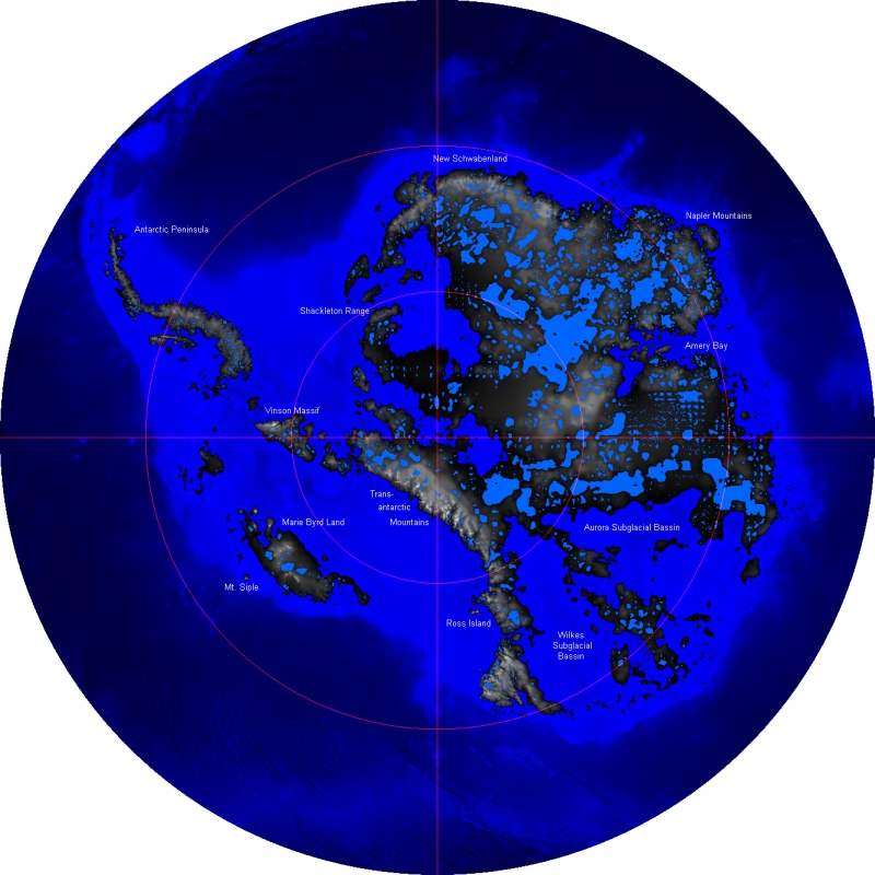
i realize youre using a mercator projection which enhances the size of antarctica, but having a global warming map with a gigantic ice sheet at the bottom bothers me...
http://upload.wikimedia.org/wikipedia/c ... urface.jpg
this image shows antarctica if the ice was removed. not taking into account sea level rise if the ice did melt...so sea level should be even higher than shown on this map!
either way id shrink down antarctica...and even if its not an accurate 'projection' id shrink it so antarctica is only in the center portion of the map, and maybe some islands that are connected instead of a large mass.
my new site - http://www.spritestitch.com/ - A video game craft weblog...

-
Lt. Valerian
- Posts: 36
- Joined: Fri Feb 09, 2007 11:24 am
- Location: United States

This map is very nice and i voted for it to continue by the way...
However i think you need to add something different to it...Different kind of gameplay or sumthing...
I thought of a little idea....
Whoever has the a country in the red zone loses one army every turn but if they have a country in the antartica they lose nothing...
Now it could be important to have a country in the red zone to break up continents of the other players¬!!
[img]http://img801.imageshack.us/img801/9761/41922610151374166770386.jpg[/mg]
-
pepperonibread
- Posts: 954
- Joined: Sun Jan 28, 2007 4:33 pm
- Location: The Former Confederacy
yeah, thats an interesting mapjohloh wrote:i realize youre using a mercator projection which enhances the size of antarctica, but having a global warming map with a gigantic ice sheet at the bottom bothers me...
http://upload.wikimedia.org/wikipedia/c ... urface.jpg
this image shows antarctica if the ice was removed. not taking into account sea level rise if the ice did melt...so sea level should be even higher than shown on this map!
either way id shrink down antarctica...and even if its not an accurate 'projection' id shrink it so antarctica is only in the center portion of the map, and maybe some islands that are connected instead of a large mass.
i'll look into it
-
wrightfan123
- Posts: 601
- Joined: Sat Jan 06, 2007 2:58 pm
- Gender: Male
- Location: Looking over every baseball team's schedule to try to determine who will win the World Series.
- Contact:
-
coconut4paws

- Posts: 301
- Joined: Tue Mar 06, 2007 7:19 pm
- Location: Im, Hungary

-
pepperonibread
- Posts: 954
- Joined: Sun Jan 28, 2007 4:33 pm
- Location: The Former Confederacy
-
coconut4paws
- Posts: 301
- Joined: Tue Mar 06, 2007 7:19 pm
- Location: Im, Hungary
-
coconut4paws
- Posts: 301
- Joined: Tue Mar 06, 2007 7:19 pm
- Location: Im, Hungary
-
wiggybowler
- Posts: 1414
- Joined: Wed Feb 21, 2007 9:40 pm
-
wrightfan123
- Posts: 601
- Joined: Sat Jan 06, 2007 2:58 pm
- Gender: Male
- Location: Looking over every baseball team's schedule to try to determine who will win the World Series.
- Contact:
-
coconut4paws
- Posts: 301
- Joined: Tue Mar 06, 2007 7:19 pm
- Location: Im, Hungary
-
pepperonibread
- Posts: 954
- Joined: Sun Jan 28, 2007 4:33 pm
- Location: The Former Confederacy

i made some changes, mostly revamping antarctica, however, i also changed the bonuses
i also added a kind of underwater effect, to show how the continents sunk, and i toned down the uninhabitable zone
besides that, i just made a few minor changes to some text and stuff
p.s. : i know the legend is too small, and i'll fix it
Last edited by pepperonibread on Thu Apr 12, 2007 6:34 am, edited 1 time in total.