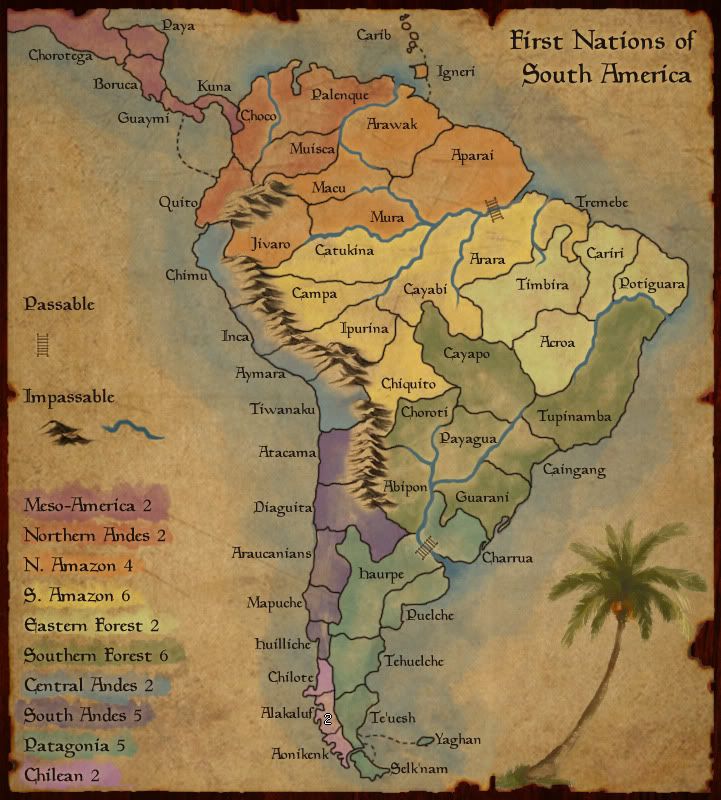
Well, i would presume the Caribbean are part of the bonus they attach to... since there is that river there I think there's little room for doubt, even without colors.
As for central andies, what about making it even lighter?
Or swapping central and south Andies or swapping chilean and central andies.
First Nations of South America!
Moderator: Cartographers
Forum rules
Please read the Community Guidelines before posting.
Please read the Community Guidelines before posting.
-
Industrial Helix

- Posts: 3462
- Joined: Mon Jul 14, 2008 6:49 pm
- Gender: Female
- Location: Ohio
Re: First Nations of South America.. UPDATE page 11
Sketchblog [Update 07/25/11]: http://indyhelixsketch.blogspot.com/
Living in Japan [Update 07/17/11]: http://mirrorcountryih.blogspot.com/
Russian Revolution map for ConquerClub [07/20/11]: http://www.conquerclub.com/forum/viewto ... 1&t=116575
Living in Japan [Update 07/17/11]: http://mirrorcountryih.blogspot.com/
Russian Revolution map for ConquerClub [07/20/11]: http://www.conquerclub.com/forum/viewto ... 1&t=116575

Re: First Nations of South America.. UPDATE page 11
Drift Igneri island and the Caribs to the right a little and enlarge one of the Caribs. Give it a little separation from the other bonus and put it more in the sphere of the bonus it belongs to.MrBenn wrote:You could artificially enlarge those islands?Evil DIMwit wrote:It's a little hard to tell what continent Carib is part of. Not sure what's the best way to fix that.
A color swap from N. Andes and Meso-America would work well too...
Does Campa and Inca connect? I guess not but perhaps that valley look could be made more of a mountain.
This post was made by jefjef who should be on your ignore list.

drunkmonkey wrote:I'm filing a C&A report right now. Its nice because they have a drop-down for "jefjef".
Re: First Nations of South America.. UPDATE page 11
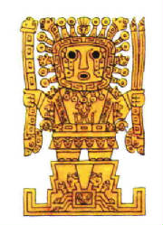
That big empty space on the left. If you don't have plans for it I think an Nazca image (only visible from the sky) or a GOD image or a warrior related image would be worth looking at inserting there.


This post was made by jefjef who should be on your ignore list.
drunkmonkey wrote:I'm filing a C&A report right now. Its nice because they have a drop-down for "jefjef".

Re: First Nations of South America.. UPDATE page 11
Whoa, that warrior is weird-looking, but seems familiar. Oh, I know, I bet he's "from France".

Re: First Nations of South America.. UPDATE page 11
Yeah... a guy Indiana Jones might be familiar with.
I dunno about the little islands, they could be a little bigger, but since they are just on territory I don't think it's a big big deal. Could you maybe add Puerto Rico to better show the color of the territory? You'd have to shift the burn mark over to the left, which will likely look better, since the top of the map from there to Central America is boringly straight. I like the spectrum effect you've got going with red to violet going from north to south so flipping colors will likely throw the balance off. I would lighten the Central Andes towards an indigo color.
I dunno about the little islands, they could be a little bigger, but since they are just on territory I don't think it's a big big deal. Could you maybe add Puerto Rico to better show the color of the territory? You'd have to shift the burn mark over to the left, which will likely look better, since the top of the map from there to Central America is boringly straight. I like the spectrum effect you've got going with red to violet going from north to south so flipping colors will likely throw the balance off. I would lighten the Central Andes towards an indigo color.


-
gimil

- Posts: 8599
- Joined: Sat Mar 03, 2007 12:42 pm
- Gender: Male
- Location: United Kingdom (Scotland)
Re: First Nations of South America.. UPDATE page 11
Hi Tisha,
Love how your map is progressing. For the most part I would say the graphics are done except a few superficial things:
-Like others have said the dead space needs to be filled up. Someing subtle like a very transparent Image would go far to solve this problem. The pictures posted by jefjef would be an excellent place to start in my opinion.
-I think most of your rivers don't work very well when they just stop at the coast. I suggesting blending then into the ocean like you did with the river between Haurpe and Charrua.
-I also noticed that in Arara there seems to be black lines that just stop. Should those be there?
Excellent work Tisha, keep it up!
What do you know about map making, bitch?
Top Score:2403natty_dread wrote:I was wrong

Update 6ish
how much does this suck?
721px × 800px
721px × 800px

Re: First Nations of South America.. Update: page THIRTEEN
FINAL FORGE THIS!!!
Highest Rank: 26 Highest Score: 3480

Re: First Nations of South America.. Update: page THIRTEEN
Compass rose maybe for the space between the legend and central America?
Small map? And lets check the color blind filter again...

hmmmmmm, maybe a shade or 2 darker on the Eastern Forest.
Small map? And lets check the color blind filter again...
hmmmmmm, maybe a shade or 2 darker on the Eastern Forest.

Re: First Nations of South America.. Update: page THIRTEEN
Not much, almost none at all in fact. I think it looks greathow much does this suck?
Only maybe, maybe smooth the ocean out into the paper background a bit more at the outer edges, but i dunno... i also like the watercolor look.
I don't need a 500px image in my signature because I don't have anything to compensate for.
-
Industrial Helix
- Posts: 3462
- Joined: Mon Jul 14, 2008 6:49 pm
- Gender: Female
- Location: Ohio
Re: First Nations of South America.. Update: page THIRTEEN
Looks great to me... though I think the tree should go.
How does the small map look?
How does the small map look?
Sketchblog [Update 07/25/11]: http://indyhelixsketch.blogspot.com/
Living in Japan [Update 07/17/11]: http://mirrorcountryih.blogspot.com/
Russian Revolution map for ConquerClub [07/20/11]: http://www.conquerclub.com/forum/viewto ... 1&t=116575
Living in Japan [Update 07/17/11]: http://mirrorcountryih.blogspot.com/
Russian Revolution map for ConquerClub [07/20/11]: http://www.conquerclub.com/forum/viewto ... 1&t=116575
-
natty dread

- Posts: 12876
- Joined: Fri Feb 08, 2008 8:58 pm
- Location: just plain fucked
Re: First Nations of South America.. Update: page THIRTEEN
I like the tree too but I still don't like the bridges.

-
Evil DIMwit

- Posts: 1616
- Joined: Thu Mar 22, 2007 1:47 pm
- Gender: Male
- Location: Philadelphia, NJ
Re: First Nations of South America.. Update: page THIRTEEN
The tree looks kind of tropical-islandish, like it belongs more in the north of the map than the south.


-
The Bison King
- Posts: 1957
- Joined: Thu Aug 27, 2009 5:06 pm
- Location: the Mid-Westeros
Re: First Nations of South America.. Update: page THIRTEEN
The trees ok, I don't hate it, but I think some Aztec or Inca artwork would be better

Re: First Nations of South America.. Update: page THIRTEEN
Inca ok, Aztec is Mexico...  Previous suggestions advocated for Nazca lines, and wouldn't be a bad idea either.

Re: First Nations of South America.. Update: page THIRTEEN
What about some kind of Patagonian cave art?


PB: 2661 | He's blue... If he were green he would die | No mod would be stupid enough to do that
-
Incandenza

- Posts: 4949
- Joined: Thu Oct 19, 2006 5:34 pm
- Gender: Male
- Location: Playing Eschaton with a bucket of old tennis balls
Re: First Nations of South America.. Update: page THIRTEEN
This seems at least worth trying, couldn't be worse than the palm tree (sorry, Tisha... rest of the map looks bitchin' tho).RedBaron0 wrote:Previous suggestions advocated for Nazca lines, and wouldn't be a bad idea either.
THOTA: dingdingdingdingdingdingBOOM
Te Occidere Possunt Sed Te Edere Non Possunt Nefas Est
Te Occidere Possunt Sed Te Edere Non Possunt Nefas Est
-
the.killing.44

- Posts: 4724
- Joined: Thu Oct 23, 2008 7:43 pm
- Gender: Male
- Location: now tell me what got two gums and knows how to spit rhymes
- Contact:
Re: First Nations of South America.. Update: page THIRTEEN
2 quick things, both about the passables (because you seem to have the artwork in the lower right under control):
1. The legend: "Passable," with one icon under it, just kinda floats out there awkwardly…is it really necessary?
2. The bridges themselves: they need some more separation from the land, like a dark glow or shadow. Nothing too extreme, but something to stop them from blending into the water/background.
-
The Bison King
- Posts: 1957
- Joined: Thu Aug 27, 2009 5:06 pm
- Location: the Mid-Westeros
Re: First Nations of South America.. Update: page THIRTEEN
Ok you got me, but I think the eye roll was a little harshInca ok, Aztec is Mexico...
Re: First Nations of South America.. Update: page THIRTEEN
Well... Aztec is a territory on FNoNA after all.The Bison King wrote:Ok you got me, but I think the eye roll was a little harshInca ok, Aztec is Mexico...
You could add the dotted connectors to the passable section.... but I agree it might not be really necessary to word it "Passables" Could just put "Bridges" as a label next to it in the legend. I agree with killing, and I wouldn't mind if you stretched out the ends a little bit. Having the ropes stretched a little in opposite directions would give the appearance of taut rope straining against gravity.the.killing.44 wrote:2 quick things, both about the passables (because you seem to have the artwork in the lower right under control):
1. The legend: "Passable," with one icon under it, just kinda floats out there awkwardly…is it really necessary?
2. The bridges themselves: they need some more separation from the land, like a dark glow or shadow. Nothing too extreme, but something to stop them from blending into the water/background.
Re: First Nations of South America.. Update: page THIRTEEN
In the legend the distance of the bridge below passable appears greater than the distance of mountains below impassable.
Would it look better with that bridge style if it was narrower? Darker?
Would it look better with that bridge style if it was narrower? Darker?
This post was made by jefjef who should be on your ignore list.
drunkmonkey wrote:I'm filing a C&A report right now. Its nice because they have a drop-down for "jefjef".
Re: First Nations of South America.. Update: page THIRTEEN
Can we move this along??
Highest Rank: 26 Highest Score: 3480
Re: First Nations of South America.. Update: page THIRTEEN
no, we can'tBruceswar wrote:Can we move this along??
because I don't like changing things I've worked on, and that I like... just because others don't like them
-
thenobodies80

- Posts: 5401
- Joined: Wed Sep 05, 2007 4:30 am
- Gender: Male
- Location: Milan
Re: First Nations of South America.. Update: page THIRTEEN
Personally i think that the palm tree is wonderful.
In any case it's your map Tisha, so no one can force you to change something without a valid reason
I have only two suggestions/concerns:
1. Bridges, i know they are my obsession since you started this map, but i can't believe that someone with your graphic skill can't draw something better than that....(no offense but actually they look like wall bars)
2. In the legend, do you really need all that empty space between the passable and the impassable? I think you should try to move up all the legend.
Except for those two things the map is Forge-ready,imo.