Alagaesia [Eragon] Map *New Look* [Page 3]
Moderator: Cartographers
Forum rules
Please read the Community Guidelines before posting.
Please read the Community Guidelines before posting.
-
Guiscard

- Posts: 4103
- Joined: Fri Dec 08, 2006 7:27 pm
- Location: In the bar... With my head on the bar
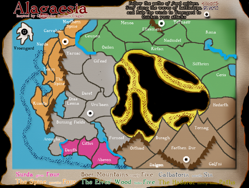
Are the territories themselves meant to be actual mountains then? If so, having smaller mountains on the edges as impassables makes no sense.
qwert wrote:Can i ask you something?What is porpose for you to open these Political topic in ConquerClub? Why you mix politic with Risk? Why you not open topic like HOT AND SEXY,or something like that.
-
Lt.Mustard

- Posts: 86
- Joined: Sat Nov 25, 2006 5:08 pm
i like the idea of having the territories shaped like mountains, and with some reworking of the graphics it could become a very appealing map. i would focus on making sure the layout will work for gameplay well before adding too much detail. keep up the good work!
Okay, lecture's over - time for some Feedback!
-
KylenPhylar
- Posts: 15
- Joined: Tue Jan 16, 2007 1:24 pm

-
DublinDoogey

- Posts: 329
- Joined: Tue Feb 28, 2006 7:03 pm
- Location: Wisconsin
Played with graphics for awhile tonight. The idea I'm trying to do is that it's an old map that's near falling apart, but, like old maps are, fun to look at and whatnot.
I understand graphics need work, with that said...
I'm looking for people to talk about playability, as there has not been any of that yet. I added names quick to make that easier, so lets talk about playability people
-
sfhbballnut
- Posts: 1687
- Joined: Fri May 05, 2006 3:01 pm
for the Beor Mountains, I suggest you use the tunnels, as connections rather than the smaller mountains as dividers. Also some sort of barrier on areas of Du Weldenvarden ( the woods) would help immensly and go along with the story. Iwould also suggest that you furthur divide the spine, it is far to open. I would also toy around with the idea of makeing the Haradac Desert either open entierly, or furthur divide its current state, possibl try having a 4 territory perimeter with some territoris inside. Generally the middle of the map is wide open, some sort of boundry could be used unless you're going for that
-
DublinDoogey
- Posts: 329
- Joined: Tue Feb 28, 2006 7:03 pm
- Location: Wisconsin
The Hadarac isn't able to to be taken, it's like trade routes or sea routes connecting the territories.
As far as dividing the Spine, do you mean into more countries? There isn't really a lot of room where the cities actually are, and I'd rather not do Southern Spine, Middle Spine, etc. I do plan on enlargening Kuasta so that there is more room for the army shadow and whatnot.
The tunnels are a good idea, but they're made to connect various parts of the mountains, not divide them, as far as the story goes. It is not necessary to have them in there, they're more for decoration, so I could simply remove them also.
Du Weldevarden only has three countries borderin other continents, including that of Vroengard, grated, one of those connects to three countries, but it's still just one location to hold. If anything, I'd remove one of the trade routes leading to it, but I'd rather not as I think that between how I've got that set up and the bit with Vroengard, those're what make the map a little more unique.
And to clarify, the countries with the symbols can attack Vroengard and be attacked by Vroengard, not all of the countries with the symbol.
-
tomatoman25
- Posts: 46
- Joined: Wed Mar 01, 2006 9:43 pm
- Location: Wisconsin
You guys remember playing Asteroids? I think that old bitmap spaceship landed and is one of those mountains.
Graphics need a lot of work, but most of all you need to make this NOT look like the middle earth map. I'm sure the books are nothing alike, and that this map may actually play much differently, but at first glance I think 'wow, this looks just like that map I never play.'
Graphics need a lot of work, but most of all you need to make this NOT look like the middle earth map. I'm sure the books are nothing alike, and that this map may actually play much differently, but at first glance I think 'wow, this looks just like that map I never play.'

-
Guiscard
- Posts: 4103
- Joined: Fri Dec 08, 2006 7:27 pm
- Location: In the bar... With my head on the bar
What the hell is the big black thing in the midle of the map? Graphics need a lot of work. What program are you using? Start from scratch and make it simpler.
qwert wrote:Can i ask you something?What is porpose for you to open these Political topic in ConquerClub? Why you mix politic with Risk? Why you not open topic like HOT AND SEXY,or something like that.
-
lord twiggy1

- Posts: 1574
- Joined: Wed Feb 14, 2007 2:26 pm
- Location: at exacltly 15 degrees N lattitud and...Ahh who the hell am i kidding I have no idea
i also have an algaesia map heres a link to it
http://www.conquerclub.com/forum/postin ... ly&t=13285
i already have some trritoris in ther but its not very realistic its just kind of a vag outline of the map
http://www.conquerclub.com/forum/postin ... ly&t=13285
i already have some trritoris in ther but its not very realistic its just kind of a vag outline of the map
Back in Black
'Cause I'm back/Yes, I'm back/Well, I'm back/Yes, I'm back/Well, I'm back, back/
Well I'm back in black/Yes, I'm back in black
That's right, I'M BACK! hopefully to stay this time!
'Cause I'm back/Yes, I'm back/Well, I'm back/Yes, I'm back/Well, I'm back, back/
Well I'm back in black/Yes, I'm back in black
That's right, I'M BACK! hopefully to stay this time!
-
lord twiggy1
- Posts: 1574
- Joined: Wed Feb 14, 2007 2:26 pm
- Location: at exacltly 15 degrees N lattitud and...Ahh who the hell am i kidding I have no idea
-
Geographical
- Posts: 189
- Joined: Wed Jan 17, 2007 4:45 am
- Location: Zapan
- Contact:
I think Four is too much for Surda and the Spine. As already mentiond, the graphics need a lot of work. I also think the borders and the country connections shold be more clear. Please consider this.DublinDoogey wrote:
Played with graphics for awhile tonight. The idea I'm trying to do is that it's an old map that's near falling apart, but, like old maps are, fun to look at and whatnot.
I understand graphics need work, with that said...
I'm looking for people to talk about playability, as there has not been any of that yet. I added names quick to make that easier, so lets talk about playability people
[url=www.conquerclub.com]
 [/url] Clicky Either One
Geography Rules!
[/url] Clicky Either OneGeography Rules!
-
rtwbarbarian

- Posts: 2
- Joined: Sun Feb 11, 2007 10:26 am
- Location: frankfurt
-
rtwbarbarian
- Posts: 2
- Joined: Sun Feb 11, 2007 10:26 am
- Location: frankfurt
-
lord twiggy1
- Posts: 1574
- Joined: Wed Feb 14, 2007 2:26 pm
- Location: at exacltly 15 degrees N lattitud and...Ahh who the hell am i kidding I have no idea


-
rocky mountain
- Posts: 415
- Joined: Thu Jul 12, 2007 7:08 pm
-
DublinDoogey
- Posts: 329
- Joined: Tue Feb 28, 2006 7:03 pm
- Location: Wisconsin

Re:
Surda needs more areas if u ask me but it looks amazing and cant wait to play
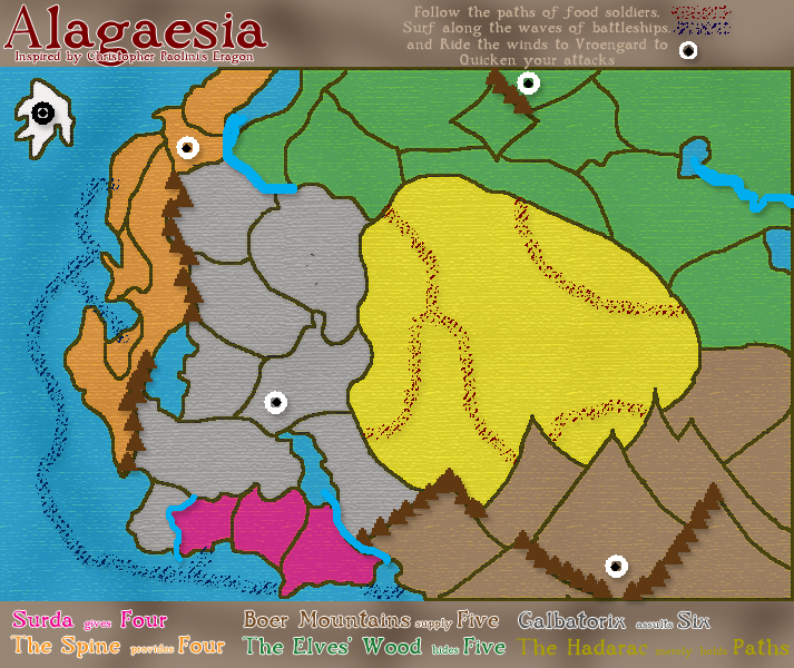
DublinDoogey wrote:Update: Version 2.0
Obviously I did a lot of work. Names still need to be added and a few boundaries will need to be adjusted, particularily in The Spine. Mountains and Rivers will be prettied up.
Impassable boundaries, trails and waves are tenative, as are bonuses. The Wind symbols all connect at the White Island in the corner, which will be more clear when names are added.
At this point I'm just looking for any disscusion on whichever parts of the map. I'll frequent the discussion, but I can't guarentee any updates within the next two weeks as my semester is finishing.
P.S. the lower legend is all words because the font I'm using doesn't have numbers.