
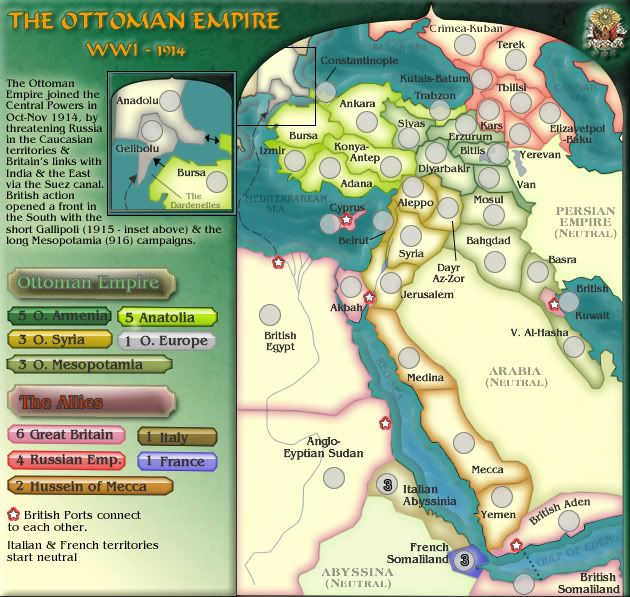
Cairnswk can you add a little arrow from gelibulo to bursa? On the real map as you got in the insert?
PS: whats the darnenells?
WWI Ottoman Empire [Quenched]
Moderator: Cartographers
Forum rules
Please read the Community Guidelines before posting.
Please read the Community Guidelines before posting.

Re: WWI: OTTOMAN EMPIRE [I] V8 P10
Just so you know, the Allies is WW II for the countries opposing the Axis. Allies in WW I would be Entente, the treaty signed by Russia, France and Great Britian to say they would help each other in war. You got Central Powers right. Good job mate  .
.
Also dardenelles is a strait into Russian waters I think? They needed to capture it so they could send supplies to Russia.
.Also dardenelles is a strait into Russian waters I think? They needed to capture it so they could send supplies to Russia.

Re: WWI: OTTOMAN EMPIRE [I] V8 P10
Yes i'll see to do thatAndroidz wrote:Cairnswk can you add a little arrow from gelibulo to bursa? On the real map as you got in the insert?
I'll change to Entente, thanks.Merker wrote:Just so you know, the Allies is WW II for the countries opposing the Axis. Allies in WW I would be Entente, the treaty signed by Russia, France and Great Britian to say they would help each other in war. You got Central Powers right. Good job mate
Also dardenelles is a strait into Russian waters I think? They needed to capture it so they could send supplies to Russia.
From Wiki http://en.wikipedia.org/wiki/DardanellesPS: whats the darnenells?
The Dardanelles (Turkish: Çanakkale Boğazı, Greek: Δαρδανέλλια, Dardanellia), formerly known as the Hellespont (Greek: Ελλήσποντος, Hellespontos), is a narrow strait in northwestern Turkey connecting the Aegean Sea to the Sea of Marmara. It is located at approximately [show location on an interactive map] 40°13′N, 26°26′E. The strait is 61 kilometers (38 mi) long but only 1.2 to 6 kilometers (0.75 to 4 mi) wide, averaging 55 meters (180 ft) deep with a maximum depth of 82 meters (300 ft). Water flows in both directions along the strait, from the Sea of Marmara to the Aegean via a surface current and in the opposite direction via an undercurrent.
* Pearl Harbour * Waterloo * Forbidden City * Jamaica * Pot Mosbi
Re: WWI: OTTOMAN EMPIRE [I] V8 P10
I'd love to see more space given to the mess of territories around Ezurum. And if everything was brought up in size a bit you might not need the inset map, though if you are going to keep it around I'd like to see the Constantinople territory named on it.
I asked this in qwert's map, and I'll ask it again here - what would happen if a territory had two sets of small and large coordinates? Could the army count for that territory be shown on both the main map and the inset? Because that would be nice in this case, where the Constantinople count can't be seen in the inset while Bursa can, and vice-versa on the main map.
I asked this in qwert's map, and I'll ask it again here - what would happen if a territory had two sets of small and large coordinates? Could the army count for that territory be shown on both the main map and the inset? Because that would be nice in this case, where the Constantinople count can't be seen in the inset while Bursa can, and vice-versa on the main map.
Re: WWI: OTTOMAN EMPIRE [I] V8 P10
oaktown, i'll look at this later in the week.
* Pearl Harbour * Waterloo * Forbidden City * Jamaica * Pot Mosbi
-
Qwert

- SoC Training Adviser
- Posts: 9262
- Joined: Tue Nov 07, 2006 5:07 pm
- Location: VOJVODINA
- Contact:
Re: WWI: OTTOMAN EMPIRE [I] V8 P10
I belive that mine answer is something like "these is question for XML experts"asked this in qwert's map, and I'll ask it again here - what would happen if a territory had two sets of small and large coordinates? Could the army count for that territory be shown on both the main map and the inset? Because that would be nice in this case, where the Constantinople count can't be seen in the inset while Bursa can, and vice-versa on the main map.


Re: WWI: OTTOMAN EMPIRE [I] V8 P10
I'm pretty sure that the second set of co-ordinates would be ignored and not shown...qwert wrote:I belive that mine answer is something like "these is question for XML experts"asked this in qwert's map, and I'll ask it again here - what would happen if a territory had two sets of small and large coordinates? Could the army count for that territory be shown on both the main map and the inset? Because that would be nice in this case, where the Constantinople count can't be seen in the inset while Bursa can, and vice-versa on the main map.
But I cannot guarantee that - you'd have to ask Lack himself.
C.

Highest score : 2297
-
Qwert
- SoC Training Adviser
- Posts: 9262
- Joined: Tue Nov 07, 2006 5:07 pm
- Location: VOJVODINA
- Contact:
Re: WWI: OTTOMAN EMPIRE [I] V8 P10
I think that these will conflicted situation,because you can not have two coordinates who represent same territory,these is mine oppinion 
Re: WWI: OTTOMAN EMPIRE [I] V8 P10
No....that is why the inset is there for that very reason, because i tried to add an arrow on the map but it was not clear enough, so the inset was done.Androidz wrote:Cairnswk can you add a little arrow from gelibulo to bursa? On the real map as you got in the insert?...
Well you should gimil, you could learn a lotgimil wrote:Come on cairns, we're not all perfect. Sometimes we don't have time to read everything you knowcairnswk wrote: I wish people would read and understand!

The layout of continents is the size it's going to be unless you're going to allow larger map sizes.oaktown wrote:I'd love to see more space given to the mess of territories around Ezurum. And if everything was brought up in size a bit you might not need the inset map, though if you are going to keep it around I'd like to see the Constantinople territory named on it.
I will clean up Around Ezurum a bit, although that is very dense in there and i don't like your chances much.
Constantinople is already in position on the main map.
i think that would only confuse people.I asked this in qwert's map, and I'll ask it again here - what would happen if a territory had two sets of small and large coordinates? Could the army count for that territory be shown on both the main map and the inset? Because that would be nice in this case, where the Constantinople count can't be seen in the inset while Bursa can, and vice-versa on the main map.
Let's stick to one set of coordinates.
* Pearl Harbour * Waterloo * Forbidden City * Jamaica * Pot Mosbi
Re: WWI: OTTOMAN EMPIRE
Current Version 8 still...
* Pearl Harbour * Waterloo * Forbidden City * Jamaica * Pot Mosbi

Re: WWI: OTTOMAN EMPIRE [I] V8 P10
There's a typo in the info paragraph - near the end, you say (916) where I believe you mean (1916).
I still have trouble telling the continents apart in the northeast.
I still have trouble telling the continents apart in the northeast.
Re: WWI: OTTOMAN EMPIRE [I] V10 P12
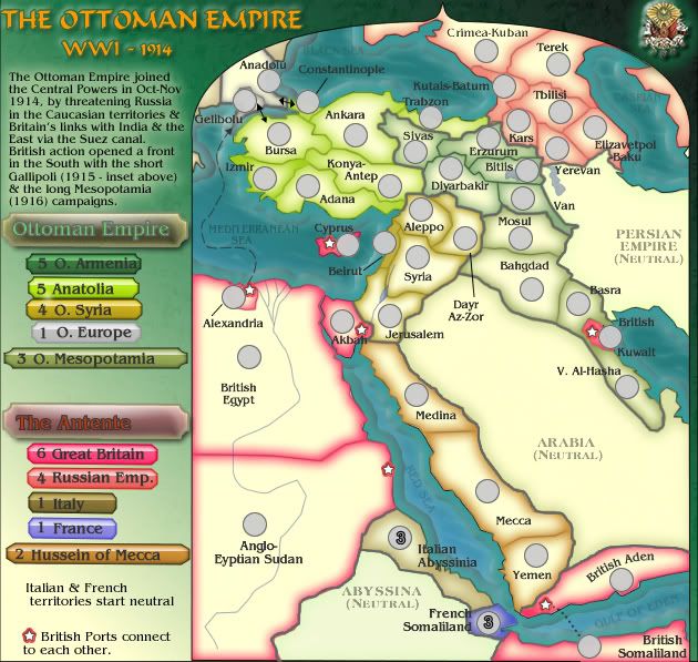
Changed to darker red....cairnswk wrote:The army circles fitted, but the one-way arrow didn't and it was very cramped compared to the rest of the map.Ruben Cassar wrote:Hey cairns...this map looks great, but why did you use the inset? Couldn't you have fitted the army circles in the main map? A mini map could be used to fill that extra space.
Yes i'm pleased you've happened along for that CB issue. I'll change those colours a bit to suit if i can.I also have some big problems to distinguish the colours. Aleppo and Adana regions look a bit similar and the pink British territories are hard to see. Perhaps a darker red would do the trick. I'm sorry to bring this up because the colour scheme is really nice but a bit confusing for my colour blind eyes.

Done....cairnswk wrote:Yes i'll see to do thatAndroidz wrote:Cairnswk can you add a little arrow from gelibulo to bursa? On the real map as you got in the insert?
but inset now gone.1916 fixedZeakCytho wrote:There's a typo in the info paragraph - near the end, you say (916) where I believe you mean (1916).
I still have trouble telling the continents apart in the northeast.
Do you still have trouble seeing the difference now with thicker continent borders?
Also oaktown, the wide legend concern has been rectifed.
- Click image to enlarge.
* Pearl Harbour * Waterloo * Forbidden City * Jamaica * Pot Mosbi
Re: WWI: OTTOMAN EMPIRE [I] V10 P12
I can tell them apart perfectly nowcairnswk wrote:Do you still have trouble seeing the difference now with thicker continent borders?
Re: WWI: OTTOMAN EMPIRE [I] V10 P11
Borders are easier to read, thanks. Maybe we should make sure nobody confuses them for impassables?
Overall layout is better... more playable area = good. And nice work getting everything in the big map.
Some little weird stuff:
"British... Kuwait" - I get that you broke it like that so the army count doesn't cross it, but it looks odd. Also, I get that the Port star is landlocked to avoid the same problem, but again it's odd. What if the army circle just went up (or down) a few pixels, and the star and text went below (or above) where the count will run?
British Somaliland seems to have an attack route directly to the facing port rather than the territory (which we're now calling a region).
The star in Anglo-Egyptian Sudan is very easy to overlook. The stars could be bigger (though they look nice now) or the title of the that region could move up and over to sit closer to the port.
Something happened to your bottom border.
Right now it's just you, me, and Zeak... where is everybody? This place is like a tomb.
Overall layout is better... more playable area = good. And nice work getting everything in the big map.
Some little weird stuff:
"British... Kuwait" - I get that you broke it like that so the army count doesn't cross it, but it looks odd. Also, I get that the Port star is landlocked to avoid the same problem, but again it's odd. What if the army circle just went up (or down) a few pixels, and the star and text went below (or above) where the count will run?
British Somaliland seems to have an attack route directly to the facing port rather than the territory (which we're now calling a region).
The star in Anglo-Egyptian Sudan is very easy to overlook. The stars could be bigger (though they look nice now) or the title of the that region could move up and over to sit closer to the port.
Something happened to your bottom border.
Right now it's just you, me, and Zeak... where is everybody? This place is like a tomb.
Re: WWI: OTTOMAN EMPIRE [I] V10 P11
Yeh...it's been like that for weeks nowoaktown wrote:...
Right now it's just you, me, and Zeak... where is everybody? This place is like a tomb.

* Pearl Harbour * Waterloo * Forbidden City * Jamaica * Pot Mosbi
Re: WWI: OTTOMAN EMPIRE [I] V10 P12
Current Version 10
- Click image to enlarge.
* Pearl Harbour * Waterloo * Forbidden City * Jamaica * Pot Mosbi
-
whitestazn88
- Posts: 3128
- Joined: Mon Feb 05, 2007 2:59 pm
- Gender: Male
- Location: behind you
- Contact:
Re: WWI: OTTOMAN EMPIRE [I] V10 P11
if i can share my 2 cents... the colors for O. armenia and o. mesopotamia look very similar on the map
as do o syria and hussein of mecca
as well as great britain and russian empire
as do o syria and hussein of mecca
as well as great britain and russian empire
Re: WWI: OTTOMAN EMPIRE [I] V10 P11
Do you have colour blind issues?whitestazn88 wrote:if i can share my 2 cents... the colors for O. armenia and o. mesopotamia look very similar on the map
as do o syria and hussein of mecca
as well as great britain and russian empire
* Pearl Harbour * Waterloo * Forbidden City * Jamaica * Pot Mosbi
-
whitestazn88
- Posts: 3128
- Joined: Mon Feb 05, 2007 2:59 pm
- Gender: Male
- Location: behind you
- Contact:
Re: WWI: OTTOMAN EMPIRE [I] V10 P11
no, they're just somewhat similar, i had to keep making sure i knew what went where, but its not so bad that i would complain about it during gameplay, just something i thought i'd say to bring up the post count
-
vonForster
- Posts: 16
- Joined: Fri Feb 01, 2008 12:00 am
Re: WWI: OTTOMAN EMPIRE [I] V10 P11
I like the map, but I feel as though having Italy and France right next to each other gives an easily defensible corner of the map. Perhaps adding Libya next to Egypt as an Italian territory and giving Italy a +2. This would also be historic as the Ottoman Empire until a relatively short time before WWI owned Libya, at least in name.
Re: WWI: OTTOMAN EMPIRE [I] V10 P11
vonForster, thanks for your suggestion.vonForster wrote:I like the map, but I feel as though having Italy and France right next to each other gives an easily defensible corner of the map. Perhaps adding Libya next to Egypt as an Italian territory and giving Italy a +2. This would also be historic as the Ottoman Empire until a relatively short time before WWI owned Libya, at least in name.
Libya is "off the map" here and i don't plan on putting it in. I have read up on that aspect about Libya.
In 1915 when the Anzac campaign was started, the idea was to secure a route to the Black Sea so that the British and Russia could link. That didn't happen, so both countries had to battle it out separately.
And that is how this map should be played.
There is a concentration of the Entente in the left lower corner which then battles north through the Ottoman Empire to capture the Middle East and bring down the Ottaman.
* Pearl Harbour * Waterloo * Forbidden City * Jamaica * Pot Mosbi

Re: WWI: OTTOMAN EMPIRE [I] V10 P11
I'm really not fond of the graphics on this map unfortunately.
The borders between continents make sense for clarity issues but they make the borders with the ocean look strange in comparison. The inconsistency stands out and not in a good way.
I'm sorry for saying this many times but I still don't like how the colours on the legend and the colours on the map don't match. I do agree with whiteazn that the colours of Syria and Mesopotamia are too similar on the map. It comes back to how you put the colours on the map. the borders only colouring is kinda cool but I'm not sure it works. Furthermore, the colours of russia and british seems too close. They might look different on the legend but that's because everything is filled in. The deep dark green of Armenia comes across as lighter and more grey like.
I do like the shapes you've got on this map. The playable area. The blocks where you put the continent names and colours. The colours look quite good there. I really wish those colours were on the map but it doesn't feel like they are.
The borders between continents make sense for clarity issues but they make the borders with the ocean look strange in comparison. The inconsistency stands out and not in a good way.
I'm sorry for saying this many times but I still don't like how the colours on the legend and the colours on the map don't match. I do agree with whiteazn that the colours of Syria and Mesopotamia are too similar on the map. It comes back to how you put the colours on the map. the borders only colouring is kinda cool but I'm not sure it works. Furthermore, the colours of russia and british seems too close. They might look different on the legend but that's because everything is filled in. The deep dark green of Armenia comes across as lighter and more grey like.
I do like the shapes you've got on this map. The playable area. The blocks where you put the continent names and colours. The colours look quite good there. I really wish those colours were on the map but it doesn't feel like they are.
Re: WWI: OTTOMAN EMPIRE [I] V10 P11
Cairns -you're *still* calling "Italian" - "Italy" & "French" - "France".
C.
C.
Highest score : 2297
Re: WWI: OTTOMAN EMPIRE [I] V10 P11
oh dear this is all too depressing, when will they ever be satisifed...i don't know if i can carry on with this stuff of constantly having to please people who constantly complain. 
* Pearl Harbour * Waterloo * Forbidden City * Jamaica * Pot Mosbi