Care to peruse completed maps? Take a stroll through the Atlas.
Moderator: Cartographers
gimil
Posts: 8599 Joined: Sat Mar 03, 2007 12:42 pmGender: MaleLocation: United Kingdom (Scotland)
Post
by gimil Sun Mar 30, 2008 4:40 pm
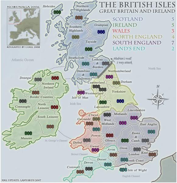
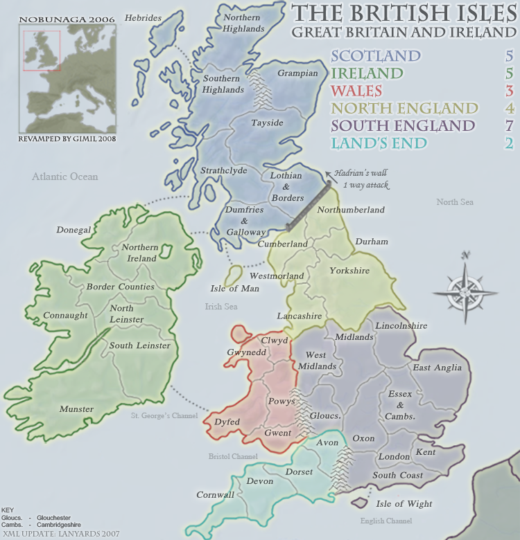
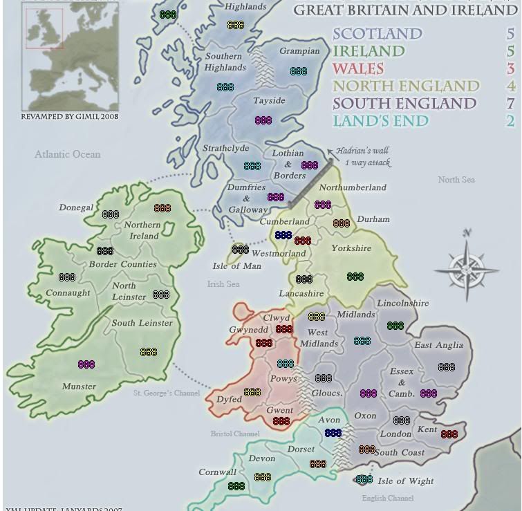
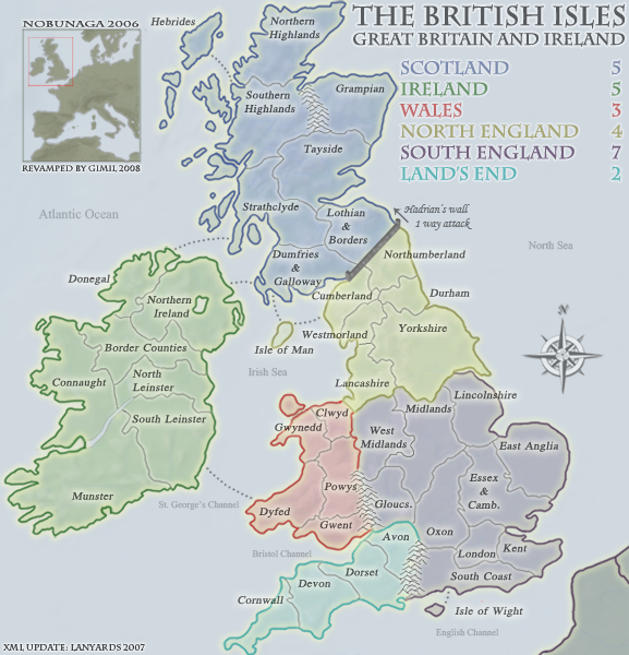
SMALL
http://i25.photobucket.com/albums/c64/G ... MALL-6.png
LARGE
http://i25.photobucket.com/albums/c64/G ... ARGE-5.png
Ian I appreciate all the work you have put in to help me get this far, but this time im putting my foot down adn saying no to your changes for england.
It has been changed so many times and with your suggestion which requires another set of unpassables jsut isnt going to happen sorry.
The unpassables:
I reworked the river, reworked some of te mountains. I decided against teh forest idea becasue it was doable in a way to fit the style of the map.
I will rework the border to elimenate the 4 way border around hadrians, but the wall itself has been tweeked a little but there not much I can do with 5 pixels.
What do you know about map making, bitch natty_dread wrote: I was wrong
Top Score:2403
WidowMakers
Posts: 2774 Joined: Mon Nov 20, 2006 9:25 amGender: MaleLocation: Detroit, MI
Post
by WidowMakers Sun Mar 30, 2008 9:54 pm
I agree with gimil. This map should have been done weeks ago. It looks great and not everyone can be pleased with each graphical aspect. Since gimil is not ignoring advice but choosing to pick his own artistic design while trying to accomidate as many as plssible I think we need to let this discussion rest.
gimil
Posts: 8599 Joined: Sat Mar 03, 2007 12:42 pmGender: MaleLocation: United Kingdom (Scotland)
Post
by gimil Sun Mar 30, 2008 10:14 pm
WidowMakers wrote: I agree with gimil. This map should have been done weeks ago. It looks great and not everyone can be pleased with each graphical aspect. Since gimil is not ignoring advice but choosing to pick his own artistic design while trying to accomidate as many as plssible I think we need to let this discussion rest.
YUP arrows over the wall
What do you know about map making, bitch natty_dread wrote: I was wrong
Top Score:2403
lord voldemort
Posts: 9596 Joined: Sat Oct 20, 2007 4:39 amGender: MaleLocation: Launceston, Australia
Contact:
Post
by lord voldemort Mon Mar 31, 2008 4:06 am
[quote="gimil"][quote="WidowMakers"]I agree with gimil. This map should have been done weeks ago. It looks great and not everyone can be pleased with each graphical aspect. Since gimil is not ignoring advice but choosing to pick his own artistic design while trying to accomidate as many as plssible I think we need to let this discussion rest.
edbeard
Posts: 2501 Joined: Thu Mar 29, 2007 12:41 am
Post
by edbeard Mon Mar 31, 2008 5:51 am
I don't like the new way you did the river. Why would a border jump across water like that?
gimil
Posts: 8599 Joined: Sat Mar 03, 2007 12:42 pmGender: MaleLocation: United Kingdom (Scotland)
Post
by gimil Mon Mar 31, 2008 8:13 am
edbeard wrote: I don't like the new way you did the river. Why would a border jump across water like that?
edbeard if I remeber correctly you where the one that didnt like the river before . . .
What do you know about map making, bitch natty_dread wrote: I was wrong
Top Score:2403
edbeard
Posts: 2501 Joined: Thu Mar 29, 2007 12:41 am
Post
by edbeard Tue Apr 01, 2008 2:02 am
I like the one in the version widowmakers posted on the last page.
Serbia
Posts: 12268 Joined: Sun Jan 14, 2007 10:10 pmGender: MaleLocation: Detroit
Post
by Serbia Fri Apr 04, 2008 7:39 am
This is one of my favorite maps, looking forward to the new revamp!
Aidan Kerr
Posts: 91 Joined: Fri Jan 04, 2008 5:44 pmLocation: Argentina
Post
by Aidan Kerr Sun Apr 06, 2008 1:44 pm
the new map looks great cant wait till i play on it
Fruitcake
Posts: 2194 Joined: Mon Aug 27, 2007 6:38 am
Post
by Fruitcake Wed Apr 09, 2008 1:37 am
I assume you are aware of the history between Lancashire and Yorkshire.
khazalid
Posts: 3407 Joined: Thu Oct 26, 2006 5:39 amLocation: scotland
Post
by khazalid Wed Apr 09, 2008 6:58 am
cool revamp, how long before its rubber-stamped ya think?
yeti_c
Posts: 9624 Joined: Thu Jan 04, 2007 9:02 amGender: Male
Post
by yeti_c Wed Apr 09, 2008 8:03 am
khazalid wrote: cool revamp, how long before its rubber-stamped ya think?
Probably a while - obviously more people need to be made aware that this map is gonna be revamped judging by the current Classic crisis.
C.
Last edited by
gimil on Wed Apr 09, 2008 3:00 pm, edited 1 time in total.
Reason: TEST BB
t-o-m
Posts: 2918 Joined: Sat Mar 22, 2008 2:22 pm
Post
by t-o-m Wed Apr 09, 2008 8:16 am
i dont like the classic - sign the petition if you dont like it
gimil
Posts: 8599 Joined: Sat Mar 03, 2007 12:42 pmGender: MaleLocation: United Kingdom (Scotland)
Post
by gimil Wed Apr 09, 2008 8:39 am
t-o-m wrote: i dont like the classic - sign the petition if you dont like it
There other channels to promote this, take it elsewhere.
What do you know about map making, bitch natty_dread wrote: I was wrong
Top Score:2403
jiminski
Posts: 5422 Joined: Tue Feb 20, 2007 3:30 pmGender: FemaleLocation: London
Post
by jiminski Wed Apr 09, 2008 12:52 pm
I actually don't mind this map change (how will the armies be presented?)
firstholliday
Posts: 1338 Joined: Sat Feb 10, 2007 1:51 pmGender: MaleLocation: Amsterdam (the fun city)
Post
by firstholliday Wed Apr 09, 2008 7:16 pm
urmmm i,m looking for the classic thread.......
7 firstholliday 3589 (58%) General 128-2 Netherlands
jiminski
Posts: 5422 Joined: Tue Feb 20, 2007 3:30 pmGender: FemaleLocation: London
Post
by jiminski Wed Apr 09, 2008 8:49 pm
firstholliday wrote: urmmm i,m looking for the classic thread.......
hehe I knowit's like a flaming maze in here!
it's in my Sig bro .. you can click on it anywhere you find me.
hulmey
Posts: 3742 Joined: Fri Nov 03, 2006 7:33 amLocation: Las Vegas
Post
by hulmey Wed Apr 09, 2008 9:07 pm
jiminski wrote: I actually don't mind this map change (how will the armies be presented?)
I already mentioned this... THe wall in the over map is much nicer! Please at least make a decent looking wall or put the old one one. At the moment it looks shit!
[img]http://img801.imageshack.us/img801/9761/41922610151374166770386.jpg[/mg]
Ruben Cassar
Posts: 2160 Joined: Thu Nov 16, 2006 6:04 amGender: MaleLocation: Civitas Invicta, Melita, Evropa
Post
by Ruben Cassar Thu Apr 10, 2008 1:54 pm
Is Camb. Cambridge? Would it be possible to write the full name for Cambridge and Gloucs. cause the abbreviations bug me?
se3lad
Posts: 5 Joined: Sun Apr 13, 2008 8:12 amLocation: London
Post
by se3lad Sun Apr 13, 2008 8:39 am
Great changes withe the flag backdrop. With the Lands End region, you could consider using the Cornish flag perhaps?
bryguy
Posts: 4381 Joined: Tue Aug 07, 2007 8:50 amLocation: Lost in a Jigsaw
Post
by bryguy Sun Apr 13, 2008 8:49 am
i wanna go to Irerand some day!
MrBenn
Posts: 6880 Joined: Wed Nov 21, 2007 9:32 amLocation: Off Duty
Post
by MrBenn Mon Apr 14, 2008 11:06 am
"Essex & Camb." should be "Essex & Cambs."
MrBenn
Posts: 6880 Joined: Wed Nov 21, 2007 9:32 amLocation: Off Duty
Post
by MrBenn Mon Apr 14, 2008 11:16 am
How about adding a tag to the current map in play to let people know that it is about to be revamped:
Click image to enlarge.
Kaplowitz
Posts: 3088 Joined: Tue May 01, 2007 5:11 pm
Post
by Kaplowitz Mon Apr 14, 2008 3:14 pm
bryguy wrote: i wanna go to Irerand some day!
Thats the only Ireland...that i know of. That is a typo right? I dont think there is an Ire
r and...not trying to be sarcastic...
gimil
Posts: 8599 Joined: Sat Mar 03, 2007 12:42 pmGender: MaleLocation: United Kingdom (Scotland)
Post
by gimil Mon Apr 14, 2008 4:03 pm
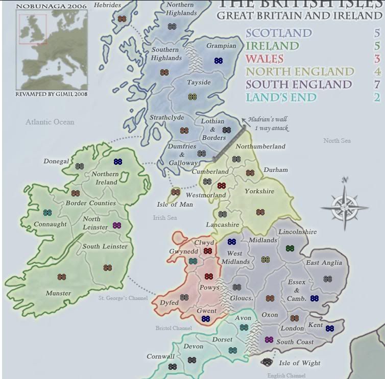
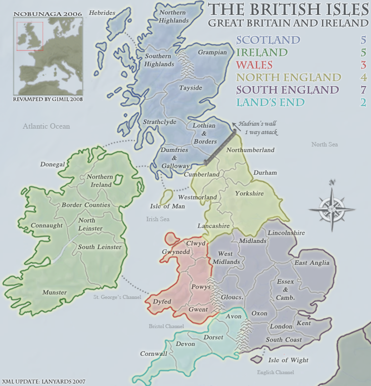
SMALL
Click image to enlarge. Click image to enlarge. Click image to enlarge.
LARGE
Click image to enlarge. Click image to enlarge. Click image to enlarge.
XML
Code: Select all
<?xml version="1.0" ?>
<map>
   <title>British Isles</title>
   <smallwidth>577</smallwidth>
   <smallheight>600</smallheight>
   <largewidth>750</largewidth>
   <largeheight>780</largeheight>
   <filetype>png</filetype>

   <continent>
      <name>Scotland</name>
      <bonus>5</bonus>
      <components>
         <component>Lothian & Borders</component>
         <component>Dumfries & Galloway</component>
         <component>Grampian</component>
         <component>Hebrides</component>
         <component>North Highlands</component>
         <component>South Highlands</component>
         <component>Strathclyde</component>
         <component>Tayside</component>
      </components>
   </continent>

   <continent>
      <name>Ireland</name>
      <bonus>5</bonus>
      <components>
         <component>Munster</component>
         <component>South Leinster</component>
         <component>North Leinster</component>
         <component>Connaught</component>
         <component>Border Counties</component>
         <component>Northern Ireland</component>
         <component>Donegal</component>
      </components>
   </continent>

   <continent>
      <name>Wales</name>
      <bonus>3</bonus>
      <components>
         <component>Clwyd</component>
         <component>Dyfed</component>
         <component>Gwent</component>
         <component>Gwynedd</component>
         <component>Powys</component>
      </components>
   </continent>

   <continent>
      <name>North England</name>
      <bonus>4</bonus>
      <components>
         <component>Cumberland</component>
         <component>Durham</component>
         <component>Isle Of Man</component>
         <component>Lancashire</component>
         <component>Northumberland</component>
         <component>Westmorland</component>
         <component>Yorkshire</component>
      </components>
   </continent>

   <continent>
      <name>South England</name>
      <bonus>7</bonus>
      <components>
         <component>West Midlands</component>
         <component>Midlands</component>
         <component>Lincolnshire</component>
         <component>Oxon</component>
         <component>Essex & Cambridge</component>
         <component>East Anglia</component>
         <component>South Coast</component>
         <component>London</component>
         <component>Kent</component>
         <component>Isle of Wight</component>
         <component>Gloucester</component>
      </components>
   </continent>

   <continent>
      <name>Land's End</name>
      <bonus>2</bonus>
      <components>
         <component>Cornwall</component>
         <component>Devon</component>
         <component>Dorset</component>
         <component>Avon</component>
      </components>
   </continent>

   <territory>
      <name>Lothian & Borders</name>
      <borders>
         <border>Dumfries & Galloway</border>
         <border>Strathclyde</border>
         <border>Tayside</border>
      </borders>
      <coordinates>
         <smallx>337</smallx>
         <smally>230</smally>
         <largex>436</largex>
         <largey>293</largey>
      </coordinates>
   </territory>

   <territory>
      <name>Dumfries & Galloway</name>
      <borders>
         <border>Lothian & Borders</border>
         <border>Isle Of Man</border>
         <border>Strathclyde</border>
         <border>Northern Ireland</border>
      </borders>
      <coordinates>
	 <smallx>297</smallx>
	 <smally>266</smally>
	 <largex>387</largex>
	 <largey>339</largey>
      </coordinates>
   </territory>

   <territory>
      <name>Grampian</name>
      <borders>
         <border>Tayside</border>
      </borders>
      <coordinates>
	<smallx>322</smallx>
	<smally>126</smally>
	<largex>420</largex>
	<largey>157</largey>
      </coordinates>
   </territory>

   <territory>
      <name>Hebrides</name>
      <borders>
         <border>South Highlands</border>
      </borders>
      <coordinates>
         <smallx>178</smallx>
         <smally>61</smally>
         <largex>231</largex>
         <largey>75</largey>
      </coordinates>
   </territory>

   <territory>
      <name>North Highlands</name>
      <borders>
         <border>South Highlands</border>
      </borders>
      <coordinates>
         <smallx>249</smallx>
         <smally>79</smally>
         <largex>329</largex>
         <largey>90</largey>
      </coordinates>
   </territory>

   <territory>
      <name>South Highlands</name>
      <borders>
         <border>Hebrides</border>
         <border>North Highlands</border>
         <border>Strathclyde</border>
         <border>Tayside</border>
      </borders>
      <coordinates>
         <smallx>238</smallx>
         <smally>143</smally>
         <largex>314</largex>
         <largey>180</largey>
      </coordinates>
   </territory>

   <territory>
      <name>Strathclyde</name>
      <borders>
         <border>Lothian & Borders</border>
         <border>Donegal</border>
         <border>Dumfries & Galloway</border>
         <border>South Highlands</border>
         <border>Tayside</border>
      </borders>
      <coordinates>
	<smallx>271</smallx>
	<smally>231</smally>
	<largex>353</largex>
	<largey>294</largey>
      </coordinates>
   </territory>

   <territory>
      <name>Tayside</name>
      <borders>
         <border>Lothian & Borders</border>
         <border>Grampian</border>
         <border>South Highlands</border>
         <border>Strathclyde</border>
      </borders>
      <coordinates>
         <smallx>281</smallx>
         <smally>183</smally>
         <largex>369</largex>
         <largey>228</largey>
      </coordinates>
   </territory>

   <territory>
      <name>South Leinster</name>
      <borders>
         <border>Dyfed</border>
         <border>Munster</border>
         <border>North Leinster</border>
      </borders>
      <coordinates>
	<smallx>155</smallx>
	<smally>438</smally>
	<largex>203</largex>
	<largey>563</largey>
      </coordinates>
   </territory>

   <territory>
      <name>Donegal</name>
      <borders>
         <border>Northern Ireland</border>
         <border>Strathclyde</border>
         <border>Border Counties</border>
      </borders>
      <coordinates>
         <smallx>115</smallx>
         <smally>283</smally>
         <largex>148</largex>
         <largey>364</largey>
      </coordinates>
   </territory>

   <territory>
      <name>Connaught</name>
      <borders>
         <border>Borders</border>
         <border>North Leinster</border>
      </borders>
      <coordinates>
         <smallx>65</smallx>
         <smally>354</smally>
         <largex>85</largex>
         <largey>455</largey>
      </coordinates>
   </territory>

   <territory>
      <name>Northern Ireland</name>
      <borders>
         <border>Donegal</border>
         <border>Dumfries & Galloway</border>
         <border>Border Counties</border>
      </borders>
      <coordinates>
	<smallx>171</smallx>
	<smally>278</smally>
	<largex>223</largex>
	<largey>355</largey>
      </coordinates>
   </territory>

   <territory>
      <name>Munster</name>
      <borders>
         <border>South Leinster</border>
      </borders>
      <coordinates>
         <smallx>83</smallx>
         <smally>460</smally>
	<largex>113</largex>
	<largey>581</largey>
      </coordinates>
   </territory>

   <territory>
      <name>Border Counties</name>
      <borders>
         <border>Connaught</border>
         <border>North Leinster</border>
         <border>Donegal</border>
         <border>Northern Ireland</border>
      </borders>
      <coordinates>
	<smallx>107</smallx>
	<smally>326</smally>
	<largex>140</largex>
	<largey>417</largey>
      </coordinates>
   </territory>

   <territory>
      <name>North Leinster</name>
      <borders>
         <border>South Leinster</border>
         <border>Border counties</border>
         <border>Connaught</border>
      </borders>
      <coordinates>
	<smallx>169</smallx>
	<smally>374</smally>
	<largex>221</largex>
	<largey>480</largey>
      </coordinates>
   </territory>

   <territory>
      <name>Clwyd</name>
      <borders>
         <border>West Midlands</border>
         <border>Gwynedd</border>
         <border>Lancashire</border>
         <border>Powys</border>
      </borders>
      <coordinates>
	<smallx>306</smallx>
	<smally>413</smally>
	<largex>399</largex>
	<largey>530</largey>
      </coordinates>
   </territory>

   <territory>
      <name>Dyfed</name>
      <borders>
         <border>South Leinster</border>
         <border>Gwent</border>
         <border>Gwynedd</border>
         <border>Powys</border>
      </borders>
      <coordinates>
         <smallx>275</smallx>
         <smally>483</smally>
         <largex>353</largex>
         <largey>621</largey>
      </coordinates>
   </territory>

   <territory>
      <name>Gwent</name>
      <borders>
         <border>Dyfed</border>
         <border>Powys</border>
      </borders>
      <coordinates>
	<smallx>303</smallx>
	<smally>515</smally>
	<largex>395</largex>
	<largey>663</largey>
      </coordinates>
   </territory>

   <territory>
      <name>Gwynedd</name>
      <borders>
         <border>Clwyd</border>
         <border>Dyfed</border>
         <border>Powys</border>
      </borders>
      <coordinates>
         <smallx>284</smallx>
         <smally>428</smally>
         <largex>370</largex>
         <largey>550</largey>
      </coordinates>
   </territory>

   <territory>
      <name>Powys</name>
      <borders>
         <border>West Midlands</border>
         <border>Clwyd</border>
         <border>Dyfed</border>
         <border>Gwent</border>
         <border>Gwynedd</border>
      </borders>
      <coordinates>
         <smallx>306</smallx>
         <smally>447</smally>
         <largex>401</largex>
         <largey>580</largey>
      </coordinates>
   </territory>

   <territory>
      <name>Cumberland</name>
      <borders>
         <border>Durham</border>
         <border>Dumfries & Galloway</border>
         <border>Isle Of Man</border>
         <border>Northumberland</border>
         <border>Westmorland</border>
	 <border>Lothian & Borders</border>
      </borders>
      <coordinates>
         <smallx>306</smallx>
         <smally>306</smally>
         <largex>398</largex>
         <largey>394</largey>
      </coordinates>
   </territory>

   <territory>
      <name>Durham</name>
      <borders>
         <border>Cumberland</border>
         <border>Northumberland</border>
         <border>Westmorland</border>
         <border>Yorkshire</border>
      </borders>
      <coordinates>
         <smallx>372</smallx>
         <smally>294</smally>
         <largex>482</largex>
         <largey>377</largey>
      </coordinates>
   </territory>

   <territory>
      <name>Isle Of Man</name>
      <borders>
         <border>Dumfries & Galloway</border>
         <border>Cumberland</border>
      </borders>
      <coordinates>
         <smallx>256</smallx>
         <smally>326</smally>
         <largex>336</largex>
         <largey>415</largey>
      </coordinates>
   </territory>

   <territory>
      <name>Lancashire</name>
      <borders>
         <border>West Midlands</border>
         <border>Clwyd</border>
         <border>Midlands</border>
         <border>Westmorland</border>
         <border>Yorkshire</border>
      </borders>
      <coordinates>
         <smallx>328</smallx>
         <smally>358</smally>
         <largex>428</largex>
         <largey>458</largey>
      </coordinates>
   </territory>

   <territory>
      <name>Northumberland</name>
      <borders>
         <border>Lothian & Borders</border>
         <border>Cumberland</border>
         <border>Durham</border>
      </borders>
      <coordinates>
	<smallx>349</smallx>
	<smally>274</smally>
	<largex>455</largex>
	<largey>350</largey>
      </coordinates>
   </territory>

   <territory>
      <name>Westmorland</name>
      <borders>
         <border>Cumberland</border>
         <border>Durham</border>
         <border>Lancashire</border>
         <border>Yorkshire</border>
      </borders>
      <coordinates>
         <smallx>327</smallx>
         <smally>316</smally>
         <largex>426</largex>
         <largey>402</largey>
      </coordinates>
   </territory>

   <territory>
      <name>Yorkshire</name>
      <borders>
         <border>Durham</border>
         <border>Lancashire</border>
         <border>Lincolnshire</border>
         <border>Midlands</border>
         <border>Westmorland</border>
      </borders>
      <coordinates>
	<smallx>385</smallx>
	<smally>354</smally>
	<largex>502</largex>
	<largey>454</largey>
      </coordinates>
   </territory>

   <territory>
      <name>West Midlands</name>
      <borders>
         <border>Clwyd</border>
         <border>Lancashire</border>
         <border>Midlands</border>
         <border>Powys</border>
         <border>Gloucester</border>
      </borders>
      <coordinates>
	<smallx>342</smallx>
	<smally>399</smally>
	<largex>446</largex>
	<largey>512</largey>
      </coordinates>
   </territory>

   <territory>
      <name>East Anglia</name>
      <borders>
         <border>Essex & Cambridgeshire</border>
         <border>Lincolnshire</border>
      </borders>
      <coordinates>
	<smallx>487</smallx>
	<smally>455</smally>
	<largex>634</largex>
	<largey>585</largey>
      </coordinates>
   </territory>

   <territory>
      <name>Essex & Cambridgeshire</name>
      <borders>
         <border>East Anglia</border>
         <border>Oxon</border>
         <border>Lincolnshire</border>
         <border>London</border>
         <border>Midlands</border>
      </borders>
      <coordinates>
	<smallx>467</smallx>
	<smally>484</smally>
	<largex>608</largex>
	<largey>623</largey>
       </coordinates>
   </territory>

   <territory>
      <name>Oxon</name>
      <borders>
         <border>Essex & Cambridgeshire</border>
         <border>London</border>
         <border>Midlands</border>
         <border>Gloucester</border>
         <border>Avon</border>
         <border>South Coast</border>
      </borders>
      <coordinates>
	<smallx>400</smallx>
	<smally>484</smally>
	<largex>521</largex>
	<largey>623</largey>
      </coordinates>
   </territory>

   <territory>
      <name>Isle of Wight</name>
      <borders>
         <border>South Coast</border>
      </borders>
      <coordinates>
	<smallx>395</smallx>
	<smally>580</smally>
	<largex>515</largex>
	<largey>747</largey>
      </coordinates>
   </territory>

   <territory>
      <name>Kent</name>
      <borders>
         <border>London</border>
         <border>South Coast</border>
      </borders>
      <coordinates>
	<smallx>490</smallx>
	<smally>530</smally>
	<largex>638</largex>
	<largey>682</largey>
      </coordinates>
   </territory>

   <territory>
      <name>Lincolnshire</name>
      <borders>
         <border>East Anglia</border>
         <border>Essex & Cambridgeshire</border>
         <border>Midlands</border>
         <border>Yorkshire</border>
      </borders>
      <coordinates>
	<smallx>430</smallx>
	<smally>409</smally>
	<largex>560</largex>
	<largey>525</largey>
      </coordinates>
   </territory>

   <territory>
      <name>London</name>
      <borders>
         <border>Essex</border>
         <border>Oxon</border>
         <border>Kent</border>
         <border>South Coast</border>
      </borders>
      <coordinates>
         <smallx>440</smallx>
         <smally>513</smally>
         <largex>569</largex>
         <largey>662</largey>
      </coordinates>
   </territory>

   <territory>
      <name>Midlands</name>
      <borders>
         <border>West Midlands</border>
         <border>Essex</border>
         <border>Oxon</border>
         <border>Lancashire</border>
         <border>Lincolnshire</border>
         <border>Gloucester</border>
         <border>Yorkshire</border>
      </borders>
      <coordinates>
	<smallx>393</smallx>
	<smally>426</smally>
	<largex>512</largex>
	<largey>547</largey>
      </coordinates>
   </territory>

   <territory>
      <name>Gloucester</name>
      <borders>
         <border>West Midlands</border>
         <border>Midlands</border>
         <border>Oxon</border>
         <border>Avon</border>
      </borders>
      <coordinates>
	<smallx>350</smallx>
	<smally>467</smally>
	<largex>456</largex>
	<largey>601</largey>
      </coordinates>
   </territory>

   <territory>
      <name>South Coast</name>
      <borders>
         <border>Oxon</border>
         <border>Isle of Wight</border>
         <border>Kent</border>
         <border>London</border>
      </borders>
      <coordinates>
         <smallx>398</smallx>
         <smally>547</smally>
         <largex>519</largex>
         <largey>704</largey>
      </coordinates>
   </territory>

   <territory>
      <name>Cornwall</name>
      <borders>
         <border>Devon</border>
      </borders>
      <coordinates>
	<smallx>253</smallx>
	<smally>587</smally>
	<largex>330</largex>
	<largey>757</largey>
      </coordinates>
   </territory>

   <territory>
      <name>Devon</name>
      <borders>
         <border>Cornwall</border>
         <border>Dorset</border>
      </borders>
      <coordinates>
	<smallx>282</smallx>
	<smally>577</smally>
	<largex>368</largex>
	<largey>744</largey>
      </coordinates>
   </territory>

   <territory>
      <name>Dorset</name>
      <borders>
         <border>Devon</border>
         <border>Avon</border>
      </borders>
      <coordinates>
	<smallx>344</smallx>
	<smally>563</smally>
	<largex>448</largex>
	<largey>725</largey>
      </coordinates>
   </territory>

   <territory>
      <name>Avon</name>
      <borders>
         <border>Dorset</border>
         <border>Gloucester</border>
         <border>Oxon</border>
      </borders>
      <coordinates>
         <smallx>362</smallx>
         <smally>531</smally>
         <largex>470</largex>
         <largey>680</largey>

      </coordinates>
   </territory>
</map>
What do you know about map making, bitch natty_dread wrote: I was wrong
Top Score:2403


