Indian Empire [Quenched]
Moderator: Cartographers
Forum rules
Please read the Community Guidelines before posting.
Please read the Community Guidelines before posting.
-
whitestazn88
- Posts: 3128
- Joined: Mon Feb 05, 2007 2:59 pm
- Gender: Male
- Location: behind you
- Contact:
-
e_i_pi

- Posts: 1775
- Joined: Tue Feb 12, 2008 2:19 pm
- Location: Corruption Capital of the world
- Contact:
Re: Indian Subcontinent - new draft pg 2
Two things:
A) The mountains in Cashmere don't seem to serve a purpose other than aesthetic
B) This is three different flavours of kick-ass
A) The mountains in Cashmere don't seem to serve a purpose other than aesthetic
B) This is three different flavours of kick-ass
-
wcaclimbing

- Posts: 5598
- Joined: Fri May 12, 2006 10:09 pm
- Location: In your quantum box....Maybe.
- Contact:
Re: Indian Subcontinent - new draft pg 2
Interesting map so far.
one issue I do see is related to the color scheme.
You've got the old paper/book thing going on, but used bright neon colors that you wouldn't see on an old paper. I suggest that you tone down the brightness of teh colors just a bit, so it fits better with the old theme of the image.
And the red lines (roads, I think) are too solid and bright right now, to the point that they color over some of the territory names. Could you make it a bit darker and put it behind the text layers? It's still be plenty visible and then you wouldn't have the problem of the lines getting in the way of other parts of the image.


Re: Indian Subcontinent - new draft pg 2
what about doing West and East Bengal because I think that area is way too big. the only problem is they'll still be almost impossible to hold. any more impassable borders you can put in here?
One thing I don't like is areas that don't belong to anything. I don't know what you'd do with Nepal and Bhotan but that really takes away from the map for me.
I see what wca is saying about the colours and agree a bit.
I like the rail bonuses. Adds to a no mans land area.
One thing I don't like is areas that don't belong to anything. I don't know what you'd do with Nepal and Bhotan but that really takes away from the map for me.
I see what wca is saying about the colours and agree a bit.
I like the rail bonuses. Adds to a no mans land area.

Re: Indian Subcontinent - new draft pg 2
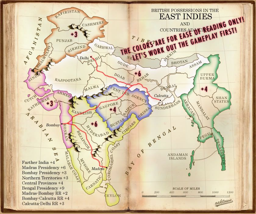
- Click image to enlarge.
What's new:
• Re-drew the Bombay Presidency to better reflect true geography. It is now five territories with three borders - a nice +3, and equal to the northern region.
• Split the giant Bengal Presidency into two regions, but now how one might expect; added the Central Provinces as a 5 territory, four border +4, and reconfigured those territories. I'm quite pleased with the huge central region because it features the railroad sub-bonus.
• Total regions not including Nepal and Bhotan = 42... doesn't get more classic.
• Total regions if we include Nepal and Bhotan = 44... I'm thinking perhaps we start them neutral, 2 armies each, and if somebody wants to hit them for a card that's their choice. Otherwise they won't see any action, which is fine because they aren't a part of British India.

Re: Indian Subcontinent - another draft pg 2
My vote is to get rid of Nepal and Bhotan altogether. They make the territory count less desirable, don't fit with any continents, and don't really serve a purpose.
The Bengal Presidency is 11 territories, with 7 borders, for a bonus of +6? I think you're undervaluing it a bit. What I think would be best is if you split it (again) into two more continents, east and west, along the line between Behar and Oude/Doab. That gives you a 6 territory, 5 border continent (west) for something like +4, and a 5 territory with 3 borders continent (east), identical in structure to the Bombay Presidency, so that would be +3. This assumes you've dropped Nepal and Bhotan.
All of those calculations ignore the railroad influence, though. So maybe this whole post is rubbish to be ignored.
Also, I don't like the colors very much
-
Juan_Bottom

- Posts: 1110
- Joined: Mon May 19, 2008 4:59 pm
- Location: USA RULES! WHOOO!!!!
Re: Indian Subcontinent - another draft pg 2
I would prefer to see it split. A few regions feature the railroad. Right now the giant center of the map is dead space. Everyone will be moving to the outskirts of the map.oaktown wrote:• Split the giant Bengal Presidency into two regions, but now how one might expect; added the Central Provinces as a 5 territory, four border +4, and reconfigured those territories. I'm quite pleased with the huge central region because it features the railroad sub-bonus.
Honestly, I could care less wich way you go, but I would prefer that we keep 'em.oaktown wrote: Total regions not including Nepal and Bhotan = 42... doesn't get more classic.
• Total regions if we include Nepal and Bhotan = 44... I'm thinking perhaps we start them neutral, 2 armies each, and if somebody wants to hit them for a card that's their choice. Otherwise they won't see any action, which is fine because they aren't a part of British India.
If you didn't tell me that it was the Giant territory, I would have no idea what one you were talking about,oaktown wrote:Re-drew the Bombay Presidency to better reflect true geography. It is now five territories with three borders - a nice +3, and equal to the northern region.
• Split the giant Bengal Presidency
Re: Indian Subcontinent - version 4, pg 3
- Click image to enlarge.
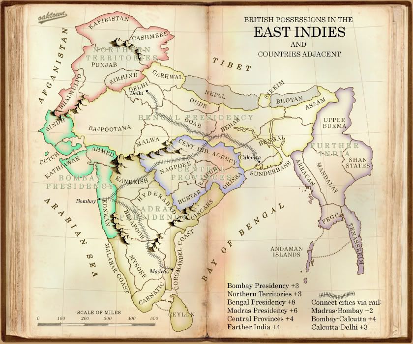
re. the "Big Region," aka Bengal Presidency: some of you are saying to split it up, but nobody is saying why. Yes, it is big. Yes it will be difficult to conquer and even harder to hold, and probably won't be held until the game is all but over anyway. But I'm concerned that splitting it into east and west regions would either give an advantage to an eastern starting player or a western starting player, depending on where it is split. The natural break would be west of Behar and Bengal, which means that a player who manages to start in Further India only has to expand a few territories and he holds a +7/+8 with only two borders.
I would encourage you all to look past the fact that the region is really big and consider how the map will play as is: there are five or six legitimate starts on this map: Further, Northern, Bombay Pres, Central Provinces, and the Delhi-Calcutta and Bombay-Madras rail lines. All are from four to six territories, and the one that is six has fewer borders and a more linear expansion than the others.
Anyway, I'm out the door. Discuss amongst yourselves.
-
wcaclimbing
- Posts: 5598
- Joined: Fri May 12, 2006 10:09 pm
- Location: In your quantum box....Maybe.
- Contact:
Re: Indian Subcontinent - version 4, pg 3
[adv. idea]

Last edited by wcaclimbing on Sat Aug 30, 2008 9:11 am, edited 2 times in total.
-
Juan_Bottom
- Posts: 1110
- Joined: Mon May 19, 2008 4:59 pm
- Location: USA RULES! WHOOO!!!!
Re: Indian Subcontinent - version 4, pg 3
I did, you big pink bully.oaktown wrote:re. the "Big Region," aka Bengal Presidency: some of you are saying to split it up, but nobody is saying why.
Right now, It's dead space on the map. The movement there will be stagnent. I don't like dead space.
And if someone can take the Purple continent, it'll be a good place to camp, because no one is going to want to rush though all that space only to be counter attacked.
That purple territory will be useless on some games, and all important on others. IMO
Re: Indian Subcontinent - version 4, pg 3
I like this version. I think leaving Nepal and Bhotan as non-playable is the way to go (not sure if that discussion is still going on or not).
I agree with keeping the large bonus area. If you hold the eastern continent and the Cent. Ind. Agency territory, you can hold it with 5 borders. It seems somewhat feasible to happen. Plus the rail bonus makes it worthwhile.
any history / random facts going to be added?
I agree with keeping the large bonus area. If you hold the eastern continent and the Cent. Ind. Agency territory, you can hold it with 5 borders. It seems somewhat feasible to happen. Plus the rail bonus makes it worthwhile.
any history / random facts going to be added?
Re: Indian Subcontinent - version 4, pg 3
I don't see it as dead space. For starters, the region contains a +3 bonus entirely within its borders, and at four territories it is the smallest regions on the map... easy to conquer for a player who can pour armies in from all sides, though admittedly difficult to hold. In addition, a player that starts either in Northern or in Farther India is ultimately going to have no choice but to move through or else find himself weak and cornered.Juan_Bottom wrote:Right now, It's dead space on the map. The movement there will be stagnent. I don't like dead space.oaktown wrote:re. the "Big Region," aka Bengal Presidency: some of you are saying to split it up, but nobody is saying why.
Fun facts about India? I'll see what I can come up with... not as much room to play with here as on the Brazil revamp.
Re: Indian Subcontinent - version 4, pg 3
good start oaktown, the feel of the graphics are good ... but at the same time i wonder if this is not the text based version
i.e. it's all words at the moment
i.e. it's all words at the moment
Re: Indian Subcontinent - version 4, pg 3
Other than the map itself, the graphics haven't received much attention. I've been thinking this map could use a mini-map with the bonuses - lose some of the text.asl80 wrote:good start oaktown, the feel of the graphics are good ... but at the same time i wonder if this is not the text based version
i.e. it's all words at the moment

Re: Indian Subcontinent - version 4, pg 3
In terms of the actual map, I have no problem with you leaving out Nepal, or Bhotan.
But if you're going to leave them out, as well as Pakistan, then you shouldn't call this map "Indian Subcontinent".
But if you're going to leave them out, as well as Pakistan, then you shouldn't call this map "Indian Subcontinent".
Re: Indian Subcontinent - version 4, pg 3
yoo-hoo... 
Re: Indian Subcontinent - version 4, pg 3
Ok, being from India I need to point out a few errors here.
1) Bhotan is wrong and should be Bhutan
2) Andaman Islands is actually known as Andaman and Nicobar Islands
3) Cashmere is the wrong spelling and correct one is Kashmir
4) Rajpootana is again wrong and should be Rajputana
5) Cutch is wrong and should be Kutch
6) Bejapoor should be Bejapur
7) Instead of Nagpore it is Nagpur
8) Instead of Bustar it is Bastar
9) Behar is wrong spelling and should be Bihar
10) Afganistan should be Afghanistan
11) Bonus for Further India is spelt wrongly.
Hope this helps.
Contact me anytime if u need to get spelling check for the Indian places again. This is one place where I can help out.
PS- I think u should try and get someone to check out the spelling of the places that are currently in Myanmar (for Arracan,Pegu and all)
Highest Score-2505 (18/07/2010)
Re: Indian Subcontinent - version 4, pg 3
Also i say that u split the Bengal Presidency into 2.
Bengal Presidency will have Assam,Bengal,Sikkim and Bihar.
(to be decided name) will have Rajputana, Malwa, Oude, Doab, Garhwal and Delhi
Just make the bonus for holding both of them smaller and that should solve the problem.
Perhaps +4 for each?
Bengal Presidency will have Assam,Bengal,Sikkim and Bihar.
(to be decided name) will have Rajputana, Malwa, Oude, Doab, Garhwal and Delhi
Just make the bonus for holding both of them smaller and that should solve the problem.
Perhaps +4 for each?
Highest Score-2505 (18/07/2010)
Re: Indian Subcontinent - version 4, pg 3
Yes, in 2008 with universally recognized spellings for these regions, these are correct. But this is a 19th century map - English spellings of Indian regions were all over the place. All of the spellings I am using I have lifted from 19th century maps - they are wrong and they are supposed to be wrong, which is part of the charm of making an old map.Shrinky wrote:Ok, being from India I need to point out a few errors here.
1) Bhotan is wrong and should be Bhutan
2) Andaman Islands is actually known as Andaman and Nicobar Islands
3) Cashmere is the wrong spelling and correct one is Kashmir
4) Rajpootana is again wrong and should be Rajputana
5) Cutch is wrong and should be Kutch
6) Bejapoor should be Bejapur
7) Instead of Nagpore it is Nagpur
Instead of Bustar it is Bastar
9) Behar is wrong spelling and should be Bihar
10) Afganistan should be Afghanistan
11) Bonus for Further India is spelt wrongly.
The further/farther is a good catch... oops!
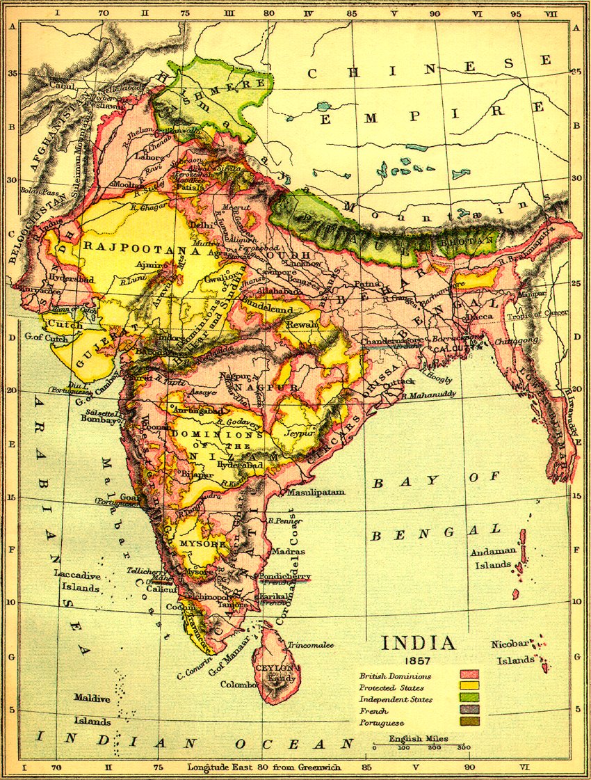
here's a nice, mid 19th century map of India... complete with Cashmere, Cutch, Behar, Bhotan, the Andaman Islands, etc. And look at any other map from that era and you'll see completely different spellings.
Oh, and I hope to get back to this project soon. very soon.
Re: British India - version 4, pg 3
ok, upon looking at this map, only Nagpore and Afganistan remains to be corrected
Although i was wondering where the Bejapoor part of the map was coming from. I only saw one place, Bijapur that remotely sounds like it(and it's only a small city, so wanted to check with u first).
Although i was wondering where the Bejapoor part of the map was coming from. I only saw one place, Bijapur that remotely sounds like it(and it's only a small city, so wanted to check with u first).
Highest Score-2505 (18/07/2010)
Re: British India - version 4, pg 3
I prefer this title 

Re: British India - version 4, pg 3
For someone with a color handicap, those bonus continent colors are strikingly similar. I guess that kinda makes sense. But there needs to be some differentiation.

Re: Indian Subcontinent - version 4, pg 3
1. I just wanted to clarify the railway bonus - do you need just the start and end points, or do you need all the territories along the route?oaktown wrote:
- Click image to enlarge.
2. The Calcutta-Delhi route increases the total for Bombay Presidency to +11 for 11 terrs... That has some sort of epic appeal
3. The Bay of Bengal and the rivers going through Bengal are very distracting... it took me a while to work out which area Bengal was... the position of the terr name helps a bit, but is still confusing...
4. The creae of the book feels a little bit too pink... is it possible to change the colour balance of the book layer to make it slightly browner?
5. the mountains could do with a little bit more variation - they look good, but I can see the recurring 'M' shape too easily
6. You mentioned the railway graphic - I've worked out why it looks out of place; there should be two tracks between the sleepers {=|=|=|=} instead of {-|-|-|-|-}
7. Have I mentioned that I like it? Keep up the good work

PB: 2661 | He's blue... If he were green he would die | No mod would be stupid enough to do that
-
eigenvector
- Posts: 95
- Joined: Tue Jul 24, 2007 4:27 am
Re: British India - version 4, pg 3
I like this map.
Suggestion about the title: why not call it British Raj?
Suggestion about the title: why not call it British Raj?
Re: British India - version 4, pg 3
I'm not too sure about British Raj as a name - I think British India will have slightly wider appeal, and conveys a bit more about the geograpahy of the map...
PB: 2661 | He's blue... If he were green he would die | No mod would be stupid enough to do that