isaiah40 wrote:Poll pulled per mapmakers request - and I forgot to post the results here
that's ok, here's the result without the numbers...
cairnswk wrote:Poll results...winners are
1. old style mountains
2. mini-map no text
Moderator: Cartographers
isaiah40 wrote:Poll pulled per mapmakers request - and I forgot to post the results here
cairnswk wrote:Poll results...winners are
1. old style mountains
2. mini-map no text


RedBaron0 wrote:I'm not an amazing stickler for that particular rule, as long as I know you are working on it. If it's gonna be like months till the next update.... then its vacation time. Just lemme know.


AndyDufresne wrote:I almost forgot about this map. I really like it, and would like to see it worked on again...I think I like it more than some of your current projects, Cairnswk!
--Andy


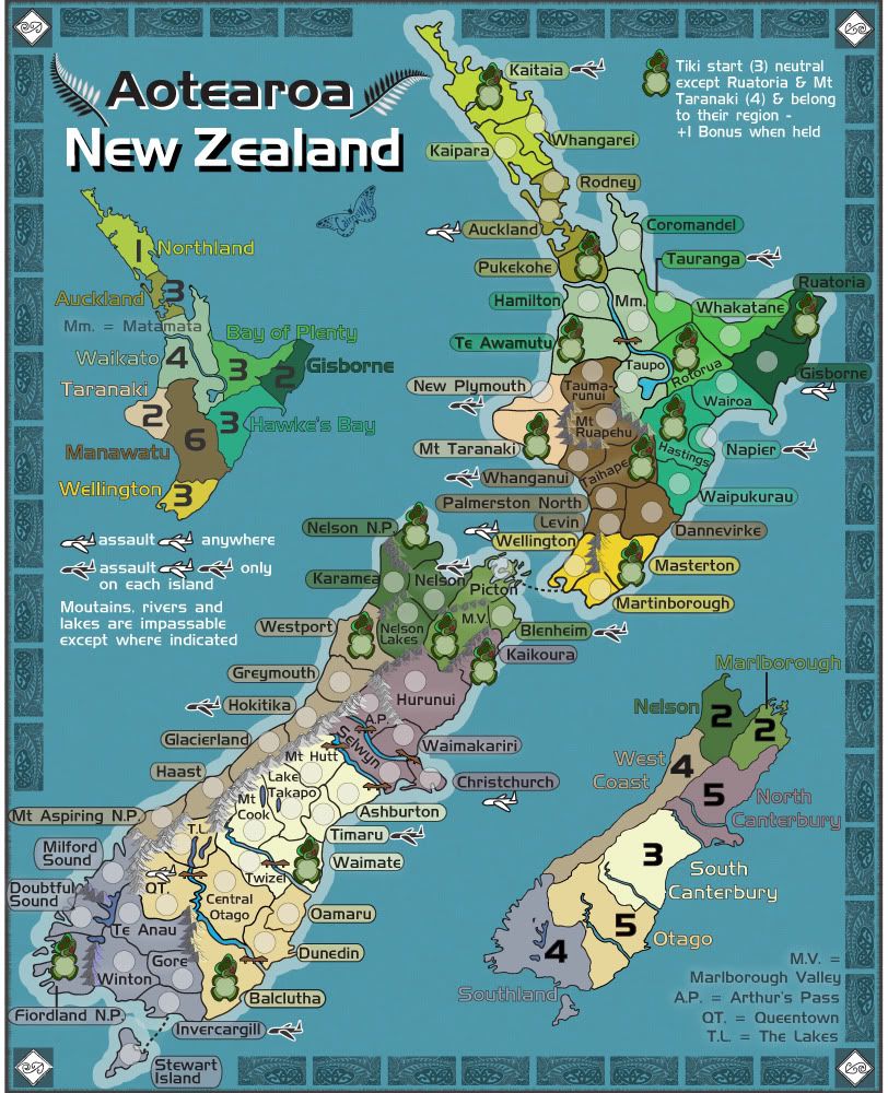
Done.theHippo wrote:Having regard to the map of Maori regions and places, here's a list of recommendations from me that may be helpful:
Focus on Nga Puhi (Kaitaia rather than Whangarei)
Done.Tainui (close enough to Pukekohe - shift from Rodney - which really isn't a Maori renown area at all)
Done.Tuhoi (Rotorua rather than Whakatane)
DoneNgati Porou (where you have Te Araroa but I'd choose Ruatoria as that has more significance)
Done.Ngati Kahungun (Hastings)
Done.Ngati Maru (Mt Taranaki - rather than Hawera
Done.Ngati Ruakawa (Taihape)
Too difficult to fit that request in, so Masterton it has to beNgati Toa (where you have Wellington - which is actually Pararaparaumu as Wellington is at the botton of the North Island where the circular harbour is - not that I'm complaining but Wellington is the Capital city!)
Made it the National ParksNgati Tama (Nelson)
Once again space prevent that.Rangitane (where you have Picton - shift from MV)
Not desirous to have two tikis side by side unless there is an impassable in-betweenNgati Apa (where you have Karamia - shift from Westport, which frankly wouldn't be classified as Maori in any way shape or form!)
Space...The rest of the South Island is pretty much considered Ngai Tahu - but you could do Ngai Tahu (where you have Hunurui - actually spelled Hurunui - but I'd shift that to Kairkoura if I were you)
Done.Te Wai Pounamu (pretty much covers it all but why not have that where you have Waimate
Balclutha doneWaitahe (where you have Clutha - actually speklled Balclutha - but I'd move that to Kaitangata if I were you)
Ah. to me Manapouri is only the lake and region around it...whereas the N.P. encompasses that whole area of the SW of the South Island, so i'll leave it there.finally Ngati Mamoe (where you have Fjordland but I'd shift that to Manapouri if I were you).


cairnswk wrote:Had to move the tiki from Hurunui to Kaikoura, so that two tikis are not side by side


AndyDufresne wrote:I'm pretty satisfied with the graphics of the map. You could consider adding a deeper / darker outline to the names of the bonus zones listed in the legends, but it may not be necessary and in fact may add too much focus to those softer areas.
Keep up the good work.
--Andy


 [/quote]


thehippo8 wrote:I wonder if there is some way to focus the game-map so it is clearly differentiated from the keys (which set out the region bonuses) ... at the moment the focus is equally on the map and the keys ... maybe it's the flatness of the sea going everywhere. Not sure if I'm being clear here but the keys are distracting in a way and the sea does seem a bit drab. I haven't got an answer to that at this stage and will think on it but hopefully you get what I mean.
koontz1973 wrote:Andy suggested it in another thread and I will say the same thing in this one about the sea. Try something like England for it maybe. Then you can have a darker part running between the 3 to break it all up a tad while keeping it all on the same level. If you get my meaning.


Nola_Lifer wrote:Leave it how it is. Don't really agree with V. 14 or comments.


thehippo8 wrote:I'll leave it to you but I liked both your suggestions but particularly liked 14a ... what was Nola's suggestion - was he happy with v13?


Users browsing this forum: No registered users