http://en.wikipedia.org/wiki/Dongbuyeo
http://en.wikipedia.org/wiki/Bukbuyeo#Dongbuyeo
Apparently Dongbuyeo would translate to "East Buyeo" which makes sense to me. "Donghuyeo" didn't bring any search results on google, so I have to assume Dongbuyeo is the correct sp.
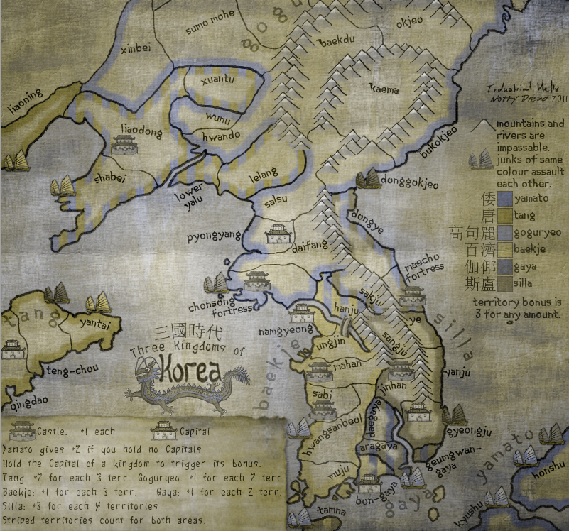
Three Kingdoms of Korea [Quenched]
Moderator: Cartographers
Re: Three Kingdoms of Korea [15.8.11]
![]() by perchorin on Sat Oct 01, 2011 3:19 am
by perchorin on Sat Oct 01, 2011 3:19 am
natty_dread wrote:http://en.wikipedia.org/wiki/Dongbuyeo
http://en.wikipedia.org/wiki/Bukbuyeo#Dongbuyeo
Apparently Dongbuyeo would translate to "East Buyeo" which makes sense to me. "Donghuyeo" didn't bring any search results on google, so I have to assume Dongbuyeo is the correct sp.
Yeah Dongbuyeo definitely sounds better. I wasn't even disputing that but everything else really looks ok

Silvanus wrote:perch is a North Korean agent to infiltrate south Korean girls
-

 perchorin
- Posts: 1859
- Joined: Mon Sep 04, 2006 8:19 am
- Location: Busan, South Korea


Re: Three Kingdoms of Korea [15.8.11]
![]() by grunion on Sun Oct 02, 2011 5:19 pm
by grunion on Sun Oct 02, 2011 5:19 pm
I vote no. I'm still not happy with the legend, which is unclear and cryptic, and the colors and territories - it all looks like shades of greyish brown to me. Maps should be playable without Bob, don't you think?
Anyway, it's clear that I'm in the minority (at least vocal-wise) so as long as that's the case I'll shut up about it. I just think it's a shame that now that Korea finally gets a map it is one that I won't be able to play.
Cheers,
grunion
Anyway, it's clear that I'm in the minority (at least vocal-wise) so as long as that's the case I'll shut up about it. I just think it's a shame that now that Korea finally gets a map it is one that I won't be able to play.
Cheers,
grunion
-
grunion
- Posts: 148
- Joined: Mon Dec 31, 2007 4:16 pm


Re: Three Kingdoms of Korea [15.8.11]
![]() by Fudoh on Mon Oct 03, 2011 10:05 am
by Fudoh on Mon Oct 03, 2011 10:05 am
maybe this has been mentioned and explained already, but why is there chinese characters on a korean map, shouldn't korean characters be used instead?
-
Fudoh
- Posts: 42
- Joined: Tue Jun 01, 2010 11:57 am


Re: Three Kingdoms of Korea [15.8.11]
![]() by natty dread on Mon Oct 03, 2011 10:37 am
by natty dread on Mon Oct 03, 2011 10:37 am
http://en.wikipedia.org/wiki/Hangul
Hangul,[nb 1] the Korean alphabet, is the native alphabet of the Korean language. It is a separate script from Hanja, the logographic Chinese characters which are also sometimes used to write Korean. It was created in the mid-15th century, and is now the official script of both North Korea and South Korea and is co-official in the Yanbian Korean Autonomous Prefecture of Jilin Province, People's Republic of China.

-

natty dread
- Posts: 12877
- Joined: Fri Feb 08, 2008 8:58 pm
- Location: just plain fucked


Re: Three Kingdoms of Korea [15.8.11]
![]() by turtlerobot on Sat Oct 08, 2011 1:20 pm
by turtlerobot on Sat Oct 08, 2011 1:20 pm
The color is drab and it's hard to read the map.
-
turtlerobot
- Posts: 3
- Joined: Sat Oct 08, 2011 11:00 am
Re: Three Kingdoms of Korea [15.8.11]
![]() by thenobodies80 on Sat Oct 08, 2011 1:50 pm
by thenobodies80 on Sat Oct 08, 2011 1:50 pm
mmm...it seems that I wasn't wrong when in april/june I said you that colors were are a problem. 
At that time you replied to me (and to others) that there wasn't a way to fix it, that was because the style of the map , etc etc and that you checked the map with colorblind filters. I decided to wait at that time...but now in beta some people is complaining again about the same thing (and you know i said you via PM that your colors are too washed imo)....anyways you have to find a way to fix it now. Fix it (and the name to change) and I'll be happy to quench this one.
At that time you replied to me (and to others) that there wasn't a way to fix it, that was because the style of the map , etc etc and that you checked the map with colorblind filters. I decided to wait at that time...but now in beta some people is complaining again about the same thing (and you know i said you via PM that your colors are too washed imo)....anyways you have to find a way to fix it now. Fix it (and the name to change) and I'll be happy to quench this one.
-

thenobodies80
- Posts: 5400
- Joined: Wed Sep 05, 2007 4:30 am
- Location: Milan


Re: Three Kingdoms of Korea [15.8.11]
![]() by natty dread on Sun Oct 09, 2011 8:03 am
by natty dread on Sun Oct 09, 2011 8:03 am
Ok, how about you just take the map offline and substract me one medal or whatever.
-
natty dread
- Posts: 12877
- Joined: Fri Feb 08, 2008 8:58 pm
- Location: just plain fucked
Re: Three Kingdoms of Korea [15.8.11]
![]() by gimil on Sun Oct 09, 2011 8:07 am
by gimil on Sun Oct 09, 2011 8:07 am
natty_dread wrote:Ok, how about you just take the map offline and substract me one medal or whatever.
Come on natty, You have come this far. There is always a fix, you just need to find it.
What do you know about map making, bitch?
Top Score:2403
natty_dread wrote:I was wrong
Top Score:2403
-

gimil
- Posts: 8599
- Joined: Sat Mar 03, 2007 12:42 pm
- Location: United Kingdom (Scotland)


Re: Three Kingdoms of Korea [15.8.11]
![]() by natty dread on Sun Oct 09, 2011 8:11 am
by natty dread on Sun Oct 09, 2011 8:11 am
gimil wrote:natty_dread wrote:Ok, how about you just take the map offline and substract me one medal or whatever.
Come on natty, You have come this far. There is always a fix, you just need to find it.
I don't currently have the time to redraw the map, so if the current image is not good enough I'm afraid there's no choice but to scrap it.
-
natty dread
- Posts: 12877
- Joined: Fri Feb 08, 2008 8:58 pm
- Location: just plain fucked
Re: Three Kingdoms of Korea [15.8.11]
![]() by koontz1973 on Sun Oct 09, 2011 8:15 am
by koontz1973 on Sun Oct 09, 2011 8:15 am
natty_dread wrote:I don't currently have the time to redraw the map, so if the current image is not good enough I'm afraid there's no choice but to scrap it.
If you do not have the time now, can it not come out of beta till you do have the time to do it. Not sure how the foundry works in this situation. It would be a real shame if we lost this. I just love looking at it.

-

koontz1973
- Posts: 6960
- Joined: Thu Jan 01, 2009 10:57 am


Re: Three Kingdoms of Korea [15.8.11]
![]() by DiM on Sun Oct 09, 2011 9:25 am
by DiM on Sun Oct 09, 2011 9:25 am
i'm not sure how natty made the image but i'm guessing it might be a very easy fix. simply take away the dark background and replace it with a lighter one.
“In the beginning God said, the four-dimensional divergence of an antisymmetric, second rank tensor equals zero, and there was light, and it was good. And on the seventh day he rested.”- Michio Kaku
-

DiM
- Posts: 10415
- Joined: Wed Feb 14, 2007 6:20 pm
- Location: making maps for scooby snacks


Re: Three Kingdoms of Korea [15.8.11]
![]() by natty dread on Sun Oct 09, 2011 3:26 pm
by natty dread on Sun Oct 09, 2011 3:26 pm
DiM wrote:i'm not sure how natty made the image but i'm guessing it might be a very easy fix.
You'd guess wrong.
simply take away the dark background and replace it with a lighter one.
Nope, that won't cut it.
The thing is, as long as I don't have the possibility to compress my own JPEG:s, I have no way of knowing how the image that ends up on the site will look like. So I'm expected to blindly balance the colours of the image so that both normal-sighted and colourblind people won't have any problems with it. Sorry but that's impossible to do.
-
natty dread
- Posts: 12877
- Joined: Fri Feb 08, 2008 8:58 pm
- Location: just plain fucked
Re: Three Kingdoms of Korea [15.8.11]
![]() by DiM on Sun Oct 09, 2011 4:00 pm
by DiM on Sun Oct 09, 2011 4:00 pm
natty_dread wrote:The thing is, as long as I don't have the possibility to compress my own JPEG:s, I have no way of knowing how the image that ends up on the site will look like. So I'm expected to blindly balance the colours of the image so that both normal-sighted and colourblind people won't have any problems with it. Sorry but that's impossible to do.
jpg compression has nothing to do with the current problem of the map. the colours are washed out even on the png.
“In the beginning God said, the four-dimensional divergence of an antisymmetric, second rank tensor equals zero, and there was light, and it was good. And on the seventh day he rested.”- Michio Kaku
-
DiM
- Posts: 10415
- Joined: Wed Feb 14, 2007 6:20 pm
- Location: making maps for scooby snacks
Re: Three Kingdoms of Korea [15.8.11]
![]() by natty dread on Sun Oct 09, 2011 4:24 pm
by natty dread on Sun Oct 09, 2011 4:24 pm
DiM wrote:natty_dread wrote:The thing is, as long as I don't have the possibility to compress my own JPEG:s, I have no way of knowing how the image that ends up on the site will look like. So I'm expected to blindly balance the colours of the image so that both normal-sighted and colourblind people won't have any problems with it. Sorry but that's impossible to do.
jpg compression has nothing to do with the current problem of the map. the colours are washed out even on the png.
Which png are you looking at? The first post isn't up to date.
-
natty dread
- Posts: 12877
- Joined: Fri Feb 08, 2008 8:58 pm
- Location: just plain fucked
Re: Three Kingdoms of Korea [15.8.11]
![]() by thenobodies80 on Sun Oct 09, 2011 4:28 pm
by thenobodies80 on Sun Oct 09, 2011 4:28 pm
In any case if you want to emulate the CC compression, you have just to set it to 80% (btw it's an issue you know I'm working on), but as DiM said in this case the colors are the problem, not the compression.
Update it then. Btw i did my test on your last one, not the one you have on the OP.
natty_dread wrote:Which png are you looking at? The first post isn't up to date
Update it then. Btw i did my test on your last one, not the one you have on the OP.
-
thenobodies80
- Posts: 5400
- Joined: Wed Sep 05, 2007 4:30 am
- Location: Milan
Re: Three Kingdoms of Korea [15.8.11]
![]() by natty dread on Sun Oct 09, 2011 4:44 pm
by natty dread on Sun Oct 09, 2011 4:44 pm
thenobodies80 wrote:In any case if you want to emulate the CC compression, you have just to set it to 80% (btw it's an issue you know I'm working on), but as DiM said in this case the colors are the problem, not the compression.
Ok, set the compression to 80. What about the other settings? Subsampling, DCT method, Smoothing, optimization? I have no idea which settings lack uses.
-
natty dread
- Posts: 12877
- Joined: Fri Feb 08, 2008 8:58 pm
- Location: just plain fucked
Re: Three Kingdoms of Korea [15.8.11]
![]() by natty dread on Sun Oct 09, 2011 4:48 pm
by natty dread on Sun Oct 09, 2011 4:48 pm
Ok, here.
- Click image to enlarge.

-
natty dread
- Posts: 12877
- Joined: Fri Feb 08, 2008 8:58 pm
- Location: just plain fucked
Re: Three Kingdoms of Korea [15.8.11]
![]() by DiM on Sun Oct 09, 2011 4:53 pm
by DiM on Sun Oct 09, 2011 4:53 pm
natty_dread wrote:Ok, here.
- Click image to enlarge.
while i'm not fond of how strong the colours are now, i'm pretty sure most people will prefer it over the old version:
- Click image to enlarge.

“In the beginning God said, the four-dimensional divergence of an antisymmetric, second rank tensor equals zero, and there was light, and it was good. And on the seventh day he rested.”- Michio Kaku
-
DiM
- Posts: 10415
- Joined: Wed Feb 14, 2007 6:20 pm
- Location: making maps for scooby snacks
Re: Three Kingdoms of Korea [15.8.11]
![]() by gimil on Sun Oct 09, 2011 4:57 pm
by gimil on Sun Oct 09, 2011 4:57 pm
I actually prefer the newer colours, it brings everything into focus. Without relinquishing to much of the grudge.
What do you know about map making, bitch?
Top Score:2403
natty_dread wrote:I was wrong
Top Score:2403
-
gimil
- Posts: 8599
- Joined: Sat Mar 03, 2007 12:42 pm
- Location: United Kingdom (Scotland)
Re: Three Kingdoms of Korea [15.8.11]
![]() by natty dread on Sun Oct 09, 2011 5:02 pm
by natty dread on Sun Oct 09, 2011 5:02 pm
DiM wrote:natty_dread wrote:Ok, here.
- Click image to enlarge.
while i'm not fond of how strong the colours are now, i'm pretty sure most people will prefer it over the old version:
- Click image to enlarge.
That's not the current version.
-
natty dread
- Posts: 12877
- Joined: Fri Feb 08, 2008 8:58 pm
- Location: just plain fucked
Re: Three Kingdoms of Korea [15.8.11]
![]() by thenobodies80 on Sun Oct 09, 2011 5:14 pm
by thenobodies80 on Sun Oct 09, 2011 5:14 pm
natty_dread wrote:thenobodies80 wrote:In any case if you want to emulate the CC compression, you have just to set it to 80% (btw it's an issue you know I'm working on), but as DiM said in this case the colors are the problem, not the compression.
Ok, set the compression to 80. What about the other settings? Subsampling, DCT method, Smoothing, optimization? I have no idea which settings lack uses.
You ask yourself about too many options. Don't worry about them, listen to me. Just set quality to 80%. (and don't use progressive images that are hateful)
This is what Lack probably does --> http://help.adobe.com/en_US/fireworks/cs/using/images/oe_UsingFW-Optimize-ImagePreview.png
As said this issue will be solved soon, even if, as I said, in this case the problem is not that the map suffers of a quality loss, but more that colors look all the same/similar for colorblind people.
The new version is much better, except for junks.
-
thenobodies80
- Posts: 5400
- Joined: Wed Sep 05, 2007 4:30 am
- Location: Milan
Re: Three Kingdoms of Korea [15.8.11]
![]() by natty dread on Sun Oct 09, 2011 5:31 pm
by natty dread on Sun Oct 09, 2011 5:31 pm
thenobodies80 wrote:You ask yourself about too many options. Don't worry about them, listen to me. Just set quality to 80%.
Ok, but those options are still there and I don't know what to set them so that the result becomes the same as what lackattack does.
And even so, how will I know it ever does? Lackattack uses a different software alltogether. How do I know lack's software doesn't use different compression algorithms that produce different results?
The % of quality isn't the only option that affects the size & quality of JPEG images.
thenobodies80 wrote:The new version is much better, except for junks.
Actually I think the new version looks like crap. The colours are horribly bright and look like someone vomited on my screen.
So maybe you should just take this map offline until I have the time to redraw it properly.
-
natty dread
- Posts: 12877
- Joined: Fri Feb 08, 2008 8:58 pm
- Location: just plain fucked
Re: Three Kingdoms of Korea [15.8.11]
![]() by natty dread on Sun Oct 09, 2011 10:19 pm
by natty dread on Sun Oct 09, 2011 10:19 pm
So, I hope this version works for you. If not, there's not much I can do.
- Click image to enlarge.

- Click image to enlarge.

 korea9.xml
- (40.9 KiB) Downloaded 1109 times
-
natty dread
- Posts: 12877
- Joined: Fri Feb 08, 2008 8:58 pm
- Location: just plain fucked
Re: Three Kingdoms of Korea [15.8.11]
![]() by gimil on Mon Oct 10, 2011 1:48 am
by gimil on Mon Oct 10, 2011 1:48 am
i think it looks pretty decent, mate.
What do you know about map making, bitch?
Top Score:2403
natty_dread wrote:I was wrong
Top Score:2403
-
gimil
- Posts: 8599
- Joined: Sat Mar 03, 2007 12:42 pm
- Location: United Kingdom (Scotland)
Who is online
Users browsing this forum: No registered users
|
|||||||
| Conquer Club is not associated with RISK online in any way. Copyright © 2006-2025 by Big Wham LLC | |||||||