Conquer Club

[Abandoned] - WWIII:Pacific Conflict

Abandoned and Vacationed maps. The final resting place, unless you recycle.

Moderator: Cartographers

Forum rules
Please read the Community Guidelines before posting.

[Abandoned] - WWIII:Pacific Conflict

Postby initus on Thu Aug 25, 2011 12:03 am

Map Name: WWIII: Pacific Conflict
Mapmaker(s): initus, skillfusniper33 for the XML
Number of Territories: Currently 114 (19 of which are neutral resets, 9 more of which start neutral so a 85 territory player start count)
Special Features: Interesting attack routes, concept, unique perspective, killer neutrals, odd bonus structures.
What Makes This Map Worthy of Being Made: I think that it is a fascinating concept of a near-future war, and hopefully people agree with me that the map would be fun to play on...

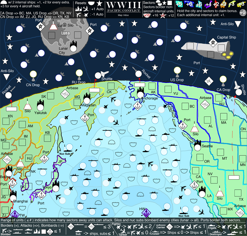
Newest Version:
Click image to enlarge.
image


Names for seemingly unnamed territories:
    The ships, subs, aircraft all have their names told in the legend, so according to that key, they will be named in the XML via "ocean, side, type" (e.g. F2 NATO Cruiser, or Western Canada SCO Bomber. Silos will also be named this way, but will not have an alliance: "Eastern Russia Silo." Ports will take the name for the land that they sit on: "Eastern US Port" or "L2 Port."

Newest Changes:
    Changes the current graphics colors to represent colors that are more natural and closer to what Earth looks like from space.
    The darker theme required white units (from black).
    Internal region cleanup (nicer borders).
    Moon territories shuffled around.
    Several territories added to space (satellites), no bonus associated with them yet (but there will be).
    Reordered the legends, got rid of the third legend (the two legends will probably be increased in size next version.

Alright, started almost from scratch, changed the perspective, etc. Personally, I like this a lot more than the previous versions, and it is easier on the eyes. Regions feel like they are sparser, which will aid in the shrinking of the map for the smaller version. Having a lot of trouble with the legend... I can't find an organization method that works with the information that I need to display. All of the needed information is currently on the legend in text form.

Concerns:
    The NATO and SCO circles are too similar.
    The current range calculations are unintuitive.
    The legend... obviously.

More territories are coming for the land areas (you can see the blank spaces).

show: Version 7

show: Version 6

show: Before Revamp

show: Original Draft
Last edited by initus on Sun Oct 09, 2011 10:33 pm, edited 18 times in total.
Image
High: [Score 2660] [Rank 182] |
User avatar
Major initus
 
Posts: 96
Joined: Sat Jan 20, 2007 4:51 pm
Location: Incognito

Re: WWIII: Pacific Conflict

Postby The Bison King on Thu Aug 25, 2011 12:54 am

Whoa!

Great concept. I'd say run with it. How long before you think you can give us a clear draft with the rules on it?
Image

Hi, my name is the Bison King, and I am COMPLETELY aware of DaFont!
User avatar
Sergeant 1st Class The Bison King
 
Posts: 1957
Joined: Thu Aug 27, 2009 5:06 pm
Location: the Mid-Westeros

Re: WWIII: Pacific Conflict

Postby initus on Thu Aug 25, 2011 2:00 am

The Bison King wrote:Whoa!

Great concept. I'd say run with it. How long before you think you can give us a clear draft with the rules on it?


Thanks for liking it! :D

Sadly I'm going to a convention this weekend so I won't have much spare time. I should be able to get something out a little more concrete early next week.
Image
High: [Score 2660] [Rank 182] |
User avatar
Major initus
 
Posts: 96
Joined: Sat Jan 20, 2007 4:51 pm
Location: Incognito

Re: WWIII: Pacific Conflict

Postby natty dread on Sat Aug 27, 2011 11:18 am

Looks like a solid concept. Now to get some graphical blingg behind it...
Image
User avatar
Sergeant 1st Class natty dread
 
Posts: 12877
Joined: Fri Feb 08, 2008 8:58 pm
Location: just plain fucked

Re: WWIII: Pacific Conflict

Postby initus on Thu Sep 01, 2011 7:23 pm

This is also mirrored in the original post. Hopefully someone else can take the time to try to understand what I am getting at with borders, attack routes, etc. This is probably a little overwhelming, but oh well.

Draft #2:
Click image to enlarge.
image

This stuff will eventually make its way into the map:
Click image to enlarge.
image

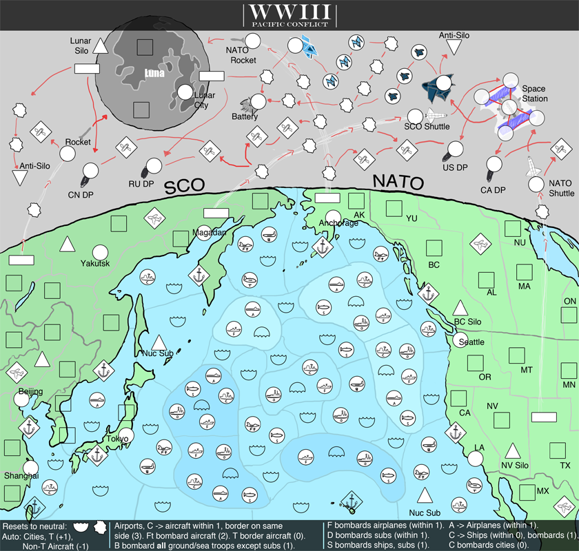
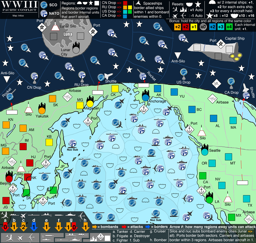
The squares on the land represent the entire "sector," which are territories in the original sense. Within each sector there are territories which border the sector they are in: cities (circles on land, +1 auto deploy), silos (triangles on land), launch pads (non-square rectangles), airports (diamonds on land), and naval bases (diamonds half on water, half of land). Ocean sectors work the same, where there is an overarching "territory" that controls the sector of water (the wavy half-circle), and then within each sector are ships, subs, aircraft, and naval bases. Ships, subs, naval bases border the sector they are in, however aircraft do not. All sector territories in the ocean that have waves pointing up reset to neutral, the others don't.

So this is on the legend at the bottom, but what is written there is basically just reminders for me until I get something a little more comprehensible. There are four types of ships: A for aircraft carrier, F for frigate, D for destroyer, C for cruiser. There are also subs and nuclear subs. Now how attacking works for ships, subs, and aircraft is that they all have a "range". This range is how many sectors away they can attack, for example if they had a range of 0, they could only attack within the sector that has the unit, however a range of 1 would also attack adjacent sectors. So, that being said, aircraft carriers attack all airplane with a range of 1. Cruisers attack ships with a range of 0, bombard cities with a range of 0, and bombard all ships with a range of 1. Frigates bombard all airplanes with a range of 1. Destroyers bombard all subs with a range of 1. Subs bombard all subs and ships with a range of 1. Nuclear subs act like silos, which I will get into later. Naval bases act as a way to get from land to the water, as they border both sectors they touch.

There are also airplanes, which if you remember do not border the sector they are in. There are three types of airplanes: Tankers (T), Fighters (Ft), and Bombers (B). Fighters bombard other aircraft with a range of 2 (this is a huge range, up to two sectors away). Bombers can attack all ships, land units and territories with a range of 1. Tankers have an auto deploy of 1, but only border other aircraft with a range of 0. Fighters and Bombers have a negative auto deploy of -1 (to simulate fuel constraints, etc). Aircraft carriers (and airports), if you remember, attack airplanes with a range of 1, this is the only way to get up to the aircraft since they don't border their sector (there is currently no way down from aircraft, I can see this being a problem but I'll leave it for now). Another thing of note is aircraft carriers and airports from the same side (darker land, darker water for SCO, lighter land and lighter water for NATO) border each other with a range of 3.

Silos on the land on either side bombard the four cities on the other side (the NATO side has 3 in NA, 1 in Tokyo). The nuclear subs bombard the 4 cities on the side they are closest to (they are subs from the other side, "second strike" simulation). There is also a silo on the moon, and this can bombard ALL cities, including the lunar city.

Now, for space. The launch pads are the way to get into space. The explosion looking "circles" reset to neutral 1, and try to represent movement through space, all of these territories. There are satellites (the diamonds), drop pods (circles with DP next to them), a battery (which bombards all satellites), anti-silos, and then some spaceships. The drop pods attack all of the sectors that correspond to their name. (CN attacks all Chinese sectors, RU is Russian, CA is Canadian, US is American). Anti-Silos bombard all of the land silos on the side they are closest to. The smaller spaceships bombard all opposing smaller spaceships from the other side (light blue vs dark blue). The borders in space is pretty much a follow the arrow ordeal, with lines with no arrow represents a mutual border.

A major thing that isn't put into the map yet is territory bonuses, there will be one per city that requires you to hold land, for holding a certain number of satellites, for holding the moon territories and city, holding a fleet sector with a certain number of its ships, holding a spacefleet, the space station. I also have thoughts of doing odd "seafaring dominance" and/or "space dominance" where if you take a certain number of the resetting neutral territories, you get a bonus. My ambitions are to put all of the bonuses in the top banner, and the borders in the bottom.

The legend will be redone along with the artwork most likely, as the two will sort of depend on each other.

----------------------------------------

I probably forgot something, but that is it for now. I know it is hard to tell some of the aircraft/subs/ships apart, and the letter underneath that signifies the type is really small, but you can still barely make it out. I can make an auxiliary legend that is blown up a bit if people are having a lot of trouble telling them apart in this draft.

Not sure if I like how space worked out, it might be changing drastically. I know about size constraints for the smaller version, will be moving stuff around, perhaps deleting a few to make that work in the future.

Edit: Added a legend to help for comprehension.

Thanks in advance for any feedback!
-initus
Image
High: [Score 2660] [Rank 182] |
User avatar
Major initus
 
Posts: 96
Joined: Sat Jan 20, 2007 4:51 pm
Location: Incognito

Re: WWIII: Pacific Conflict (updated 9/3/11, v3)

Postby initus on Sat Sep 03, 2011 4:42 am

New draft... redid the space and I like it a little better, not completely what I am looking for but in the right direction I would say. This one is a little easier to comprehend I think, so hopefully it won't scare as many people off as the last one did...

Looking for thoughts on the gameplay (if someone could take the time to look it over), and whether or not the map interests people.

I know I am running into space constraints here, as I have a bit to still fit into the legend. I might have to go super size on this map, (barely... if I do it would only be a few pixels added to the height) as the banners are already eating into the playing area, which I am not all that happy about.

Click image to enlarge.
image

This is sort of in the legend, but I have no idea if it is intuitive or not. The squares on the land represent the entire "sector," which are territories in the original sense. Within each sector there are territories which border the sector they are in (I call them units): cities (circles on land, +1 auto deploy), silos (triangles on land), launch pads (non-square rectangles), airports (diamonds on land), and naval bases (diamonds half on water, half of land). Ocean sectors work the same, where there is an overarching "territory" that controls the sector of water (the wavy half-circle), and then within each sector are ships, subs, aircraft, and naval bases.

Yet to add to the legend:
Silos on the land on either side bombard the four cities on the other side (the NATO side has 3 in NA, 1 in Tokyo). The nuclear subs bombard the 4 cities on the side they are closest to (they are subs from the other side, "second strike" simulation). There is also a silo on the moon, and this can bombard ALL cities, including the lunar city.

The drop pods attack all of the sectors that correspond to their name. (CN attacks all Chinese sectors, RU is Russian, CA is Canadian, US is American). Anti-Silos bombard all of the land silos on the side they are closest to. The smaller spaceships bombard all opposing smaller spaceships from the other side (light blue vs dark blue). The borders in space is pretty much a follow the arrow ordeal, with lines with no arrow represents a mutual border.

Naval bases border the land and sea sectors they touch, the space port borders the lunar land and the space sector it touches.

A major thing that isn't put into the map yet is territory bonuses, there will be one per city that requires you to hold land, for holding a certain number of satellites, for holding the moon territories and city, holding a fleet sector with a certain number of its ships, holding a spacefleet, the space station. I also have thoughts of doing odd "seafaring dominance" and/or "space dominance" where if you take a certain number of the resetting neutral territories, you get a bonus. My ambitions are to put all of the bonuses in the top banner, and the borders in the bottom.
Image
High: [Score 2660] [Rank 182] |
User avatar
Major initus
 
Posts: 96
Joined: Sat Jan 20, 2007 4:51 pm
Location: Incognito

Re: WWIII: Pacific Conflict (Updated 9/6/11, v4)

Postby initus on Tue Sep 06, 2011 3:40 pm

Another version, if someone would finally give me feedback I would greatly appreciate it... I REALLY want to know what people think about the gameplay.

Click image to enlarge.
image


Almost got everything in the legend, it should all fit in eventually.

Yet to add to the legend:
The nuclear sub closest to either side is an enemy to that side.
Spaceship bonuses aren't in yet, neither are their borders. Spaceships will be able to mutually attack (border) allied spaceships within 2, and bombard enemies within 0. The bonuses... probably +2 for 5 on the same side, +5 for all 8 or something to that effect.

Changes:
    Space was redone.
    Bonuses put in.
    Unit graphics redone to something closer to what I wanted them to be.
    Reordering and additions to the banners.
    Probably some other stuff.

Don't worry too much about the bonus numbers, as those are basically rough estimates/guesses.
Image
High: [Score 2660] [Rank 182] |
User avatar
Major initus
 
Posts: 96
Joined: Sat Jan 20, 2007 4:51 pm
Location: Incognito

Re: WWIII: Pacific Conflict (Updated 9/6/11, v4)

Postby natty dread on Tue Sep 06, 2011 5:52 pm

Well, the gameplay looks so convoluted I have no idea what's happening there. There's just too much stuff going on...
Image
User avatar
Sergeant 1st Class natty dread
 
Posts: 12877
Joined: Fri Feb 08, 2008 8:58 pm
Location: just plain fucked

Re: WWIII: Pacific Conflict (Updated 9/6/11, v4)

Postby initus on Tue Sep 06, 2011 6:25 pm

natty_dread wrote:Well, the gameplay looks so convoluted I have no idea what's happening there. There's just too much stuff going on...


Well did you try to figure it out or did you just give up at the sight of it... Not every map is single glance comprehension, take Waterloo, Stalingrad, etc.

Although I do admit I need to get the map more user friendly, the stuff is there to learn it, however I might have to explain a few things. If you remove all the aircraft, cities, spaceships, and all of the other units, all you would have left on the map are the sectors (squares, wavy semi-circles, stars), which act as normal territories in the strictest sense. Now if you take this into consideration, add all of the other stuff back in, the stuff that are not sectors border only the sector they are in (unless otherwise stated by the legend).

Though I will be working to make it less convoluted and still keep the current gameplay.
Image
High: [Score 2660] [Rank 182] |
User avatar
Major initus
 
Posts: 96
Joined: Sat Jan 20, 2007 4:51 pm
Location: Incognito

Re: WWIII: Pacific Conflict (Updated 9/6/11, v4)

Postby natty dread on Tue Sep 06, 2011 6:53 pm

Firstly: you're going to need to make the map less cluttered. Probably have to make it larger too, apply for supersize and all that. You've crammed as much stuff as you can fit in the 800x800 image, but a map needs to have small & large images, and I don't think this can be shrunk any smaller...

Second: you need to make the different icons more distinct and easy to tell apart. Currently, it's a mess - you have all these small black icons denoting different types of territories, and they're explained somewhere in the legend but there's no easy visual system for a player to visualize them.

Also, you need territory names... the sea & space territories have no labels on them, how exactly is anyone going to tell them apart?
Image
User avatar
Sergeant 1st Class natty dread
 
Posts: 12877
Joined: Fri Feb 08, 2008 8:58 pm
Location: just plain fucked

Re: WWIII: Pacific Conflict (Updated 9/6/11, v4)

Postby initus on Tue Sep 06, 2011 6:58 pm

natty_dread wrote:Firstly: you're going to need to make the map less cluttered. Probably have to make it larger too, apply for supersize and all that. You've crammed as much stuff as you can fit in the 800x800 image, but a map needs to have small & large images, and I don't think this can be shrunk any smaller...


Yeah, I know... probably should. I was going to restructure some of the territories before I shrunk it down so stuff could fit, as I was just working with the large version.

natty_dread wrote:Second: you need to make the different icons more distinct and easy to tell apart. Currently, it's a mess - you have all these small black icons denoting different types of territories, and they're explained somewhere in the legend but there's no easy visual system for a player to visualize them.


Agreed, I'll work on that.

natty_dread wrote:Also, you need territory names... the sea & space territories have no labels on them, how exactly is anyone going to tell them apart?


Haven't gotten to that part yet, been focusing on the other stuff. :)
Figured it would just be a letter-number ordeal.

Thanks for the feedback... at least you cared enough to say something about it.
Image
High: [Score 2660] [Rank 182] |
User avatar
Major initus
 
Posts: 96
Joined: Sat Jan 20, 2007 4:51 pm
Location: Incognito

Re: WWIII: Pacific Conflict (Updated 9/11/11, v5)

Postby initus on Sun Sep 11, 2011 8:37 pm

Worked on spacing and clutter a bit, tried to make the units a little easier to tell apart.

Click image to enlarge.
image


Yet to add to the legend:
    Spaceship bonuses aren't in yet: probably +2 for 3 on the same side, +5 for all 7 or something to that effect.
    Anti-silos bombard the cities on the side they are closest to.

Haven't added names to the space/ocean regions, keep on forgetting to do that.

Questions:
    Is the map easier to understand/read?
    Are there any parts of the legend that are unclear?
    Are the units (in particular the ships and aircraft) easy enough to tell apart?
    Does the map seem interesting?

Thanks for any responses.
Image
High: [Score 2660] [Rank 182] |
User avatar
Major initus
 
Posts: 96
Joined: Sat Jan 20, 2007 4:51 pm
Location: Incognito

Re: WWIII: Pacific Conflict (Updated 9/11/11, v5)

Postby Tismypueblo on Mon Sep 12, 2011 4:34 pm

initus wrote:Questions:
    Is the map easier to understand/read?
    Are there any parts of the legend that are unclear?
    Are the units (in particular the ships and aircraft) easy enough to tell apart?
    Does the map seem interesting?

Not particuarly, then again I've never liked the massive war maps, so that could be part of the problem.

The arrows are confusing. Are they supposed to be pointing to the grey unit below?

They are fairly distinct ships.

It's not something I would play, but again that is due to my dislike of large war maps. Though if there is enough interest, you should definitely push forward.
User avatar
Corporal 1st Class Tismypueblo
 
Posts: 66
Joined: Fri Dec 10, 2010 9:34 pm

Re: WWIII: Pacific Conflict (Updated 9/11/11, v5)

Postby initus on Mon Sep 12, 2011 7:28 pm

Tismypueblo wrote:Not particuarly, then again I've never liked the massive war maps, so that could be part of the problem.

The arrows are confusing. Are they supposed to be pointing to the grey unit below?

They are fairly distinct ships.

It's not something I would play, but again that is due to my dislike of large war maps. Though if there is enough interest, you should definitely push forward.


That's nice that you don't like large war maps... but why do you think that is? What are the problems with large war maps that causes an aversion to you and what do you think they could do better?

Each gray group contains units that the upper units can attack.

I'll be revamping everything to start from a new perspective, as this map got a little convoluted, so anything that you could give me to try to interest the non-world war map crowd would help.

Thanks,
initus
Image
High: [Score 2660] [Rank 182] |
User avatar
Major initus
 
Posts: 96
Joined: Sat Jan 20, 2007 4:51 pm
Location: Incognito

Re: WWIII: Pacific Conflict (Updated 9/11/11, v5)

Postby Bruceswar on Mon Sep 12, 2011 11:30 pm

interesting map. How do you plan to label it? Territories that is.
Highest Rank: 26 Highest Score: 3480
Image
User avatar
Corporal Bruceswar
 
Posts: 9713
Joined: Sun Dec 23, 2007 12:36 am
Location: Cow Pastures

Re: WWIII: Pacific Conflict (Updated 9/11/11, v5)

Postby Underated on Tue Sep 13, 2011 3:38 am

Ini, I think this is a terrific concept for a map. I love the opposing sides. I love the adventure out into space and the muliple attack avenues.

I see the collision between the 2 maps are, WW1 beach land and USSR v USA nuke one.

I dont think the concept need change but complex attack route via the 2 opposing land masses need to be neated up. the use of artillery, naval and airforce assests is vital. How you do this, there a lots of great maps that demonstrate multiple attack route (like kings court, you favourite)
Based on that airforce can move larger distance, boats are slower but bigger to destroy, and so on...complex but simple.

On the land mass, I would love to see the technological age represented more with a difficult nuetral to pass (+50) as computer hacker sits waiting to be utilised to hit some vital elements maybe even the generators (power/production elements) on the opposing side + big bonus once owned.

As for the race the multiple attack routes would be excellent if it was more cross ladder attack into space. So both land masses can climb the ladder via the technological advances and both looking to reach the pinnacle first to gain control of the ultimate weapon.

LAZER beam....(little pinkee in mouth) that has the adavantage of being a reset or open nuetral that can hit eveything back to zero, nil, zip...

Perhaps I am being a bit Austin Powers about this, but that is what the map made me immediately think of.

Good luck with it, I hope I helped.
Image
User avatar
Captain Underated
 
Posts: 157
Joined: Wed Jul 30, 2008 12:17 am
Location: Here not there.

Re: WWIII: Pacific Conflict (Updated 9/14/11, v6) *Revamped*

Postby initus on Wed Sep 14, 2011 9:49 pm

Newest Version:
Click image to enlarge.
image


Names for seemingly unnamed territories:
    The ships, subs, aircraft all have their names told in the legend, so according to that key, they will be named in the XML via "ocean, type, side" (e.g. F2 NATO Cruiser, or Western Canada SCO Bomber. Silos will also be named this way, but will not have an alliance: "Eastern Russia Silo." Ports will take the name for the land that they sit on: "Eastern US Port" or "L2 Port." The Lunar city has not been named yet but will be and is obvious(?) what it is.

Bruceswar wrote:interesting map. How do you plan to label it? Territories that is.


Like that ;) . The individual units don't need labeling as their alliance and type are specified elsewhere.

Underated wrote:I dont think the concept need change but complex attack route via the 2 opposing land masses need to be neated up. the use of artillery, naval and airforce assests is vital. How you do this, there a lots of great maps that demonstrate multiple attack route (like kings court, you favourite)Based on that airforce can move larger distance, boats are slower but bigger to destroy, and so on...complex but simple.


Thanks Under, although the map has changed a lot since you commented on it. I think I managed to clean up the map and make it easier to understand.

------------------

Alright, started almost from scratch, changed the perspective, etc. Personally, I like this a lot more than the previous versions, and it is easier on the eyes. Regions feel like they are sparser, which will aid in the shrinking of the map for the smaller version. Having a lot of trouble with the legend... I can't find an organization method that works with the information that I need to display. All of the needed information is currently on the legend in text form.

Concerns:
    The NATO and SCO circles are too similar.
    The current range calculations are unintuitive.
    The legend... obviously.

More territories are coming for the land, space areas (you can see the blank spaces).

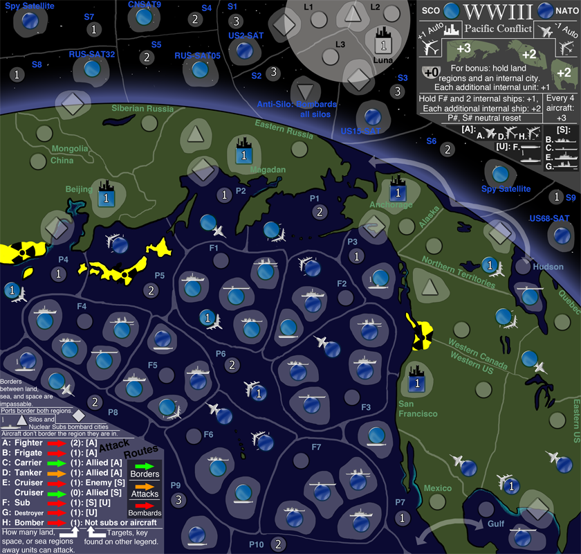
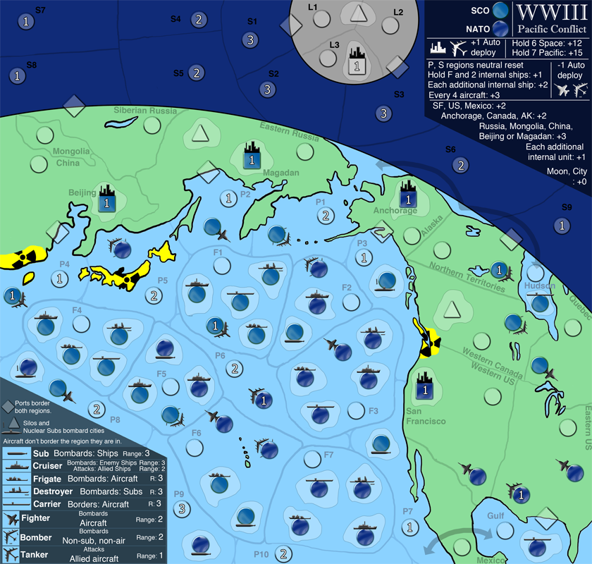
Okay, now back to the range calculations. As can be seen, each ship and sub got its own small region that is entirely contained by the larger, ocean region. This should help for differentiation between aircraft and ships, and also make it a little easier to understand.

An exercise that would be EXTREMELY helpful if people would do:
    Find the NATO Cruiser in the ocean region F7. Now find the SCO Frigate in the ocean region F6. What do you think the legend should say for a range on the Cruiser so it would be able to bombard the Frigate? Please decide before my ramblings sway your opinion and post what you got (hopefully the most intuitive answer) and your reasoning behind it.

    Currently the legend uses this method of range from the Cruiser to the Frigate: NATO Cruiser -> F7 -> F6 -> SCO Frigate, which comes out to be a range of 3. However, the aircraft need to use a different method because they don't border the ocean region they are in, however they use it for range (e.g. A range of 1 would attack aircraft in bordering ocean regions, while a range of two attacks two away). I know this is a mess, but I am not quite sure what to do...
Last edited by initus on Fri Sep 16, 2011 1:56 pm, edited 3 times in total.
Image
High: [Score 2660] [Rank 182] |
User avatar
Major initus
 
Posts: 96
Joined: Sat Jan 20, 2007 4:51 pm
Location: Incognito

Re: WWIII: Pacific Conflict (Updated 9/14/11, v6) *Revamped*

Postby Nola_Lifer on Fri Sep 16, 2011 1:46 pm

Was is this still in Melting pot. Seems like a pretty solid idea so far. Nice work Initus!!!!
Image
User avatar
Major Nola_Lifer
 
Posts: 819
Joined: Mon Oct 13, 2008 4:46 pm
Location: 雪山

Re: WWIII: Pacific Conflict (Updated 9/14/11, v6) *Revamped*

Postby initus on Tue Sep 20, 2011 9:22 pm

Nola_Lifer wrote:Was is this still in Melting pot. Seems like a pretty solid idea so far. Nice work Initus!!!!


Thanks Nola! :D

-----------------------------

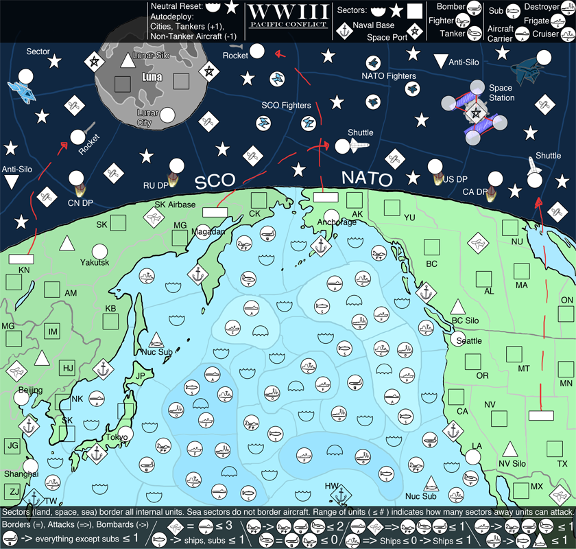
New version:

Click image to enlarge.
image


Note: The text "P, S regions neutral reset" got lost in the update somehow, it will be back next one.

Names for seemingly unnamed territories:
    The ships, subs, aircraft all have their names told in the legend, so according to that key, they will be named in the XML via "ocean, side, type" (e.g. F2 NATO Cruiser, or Western Canada SCO Bomber. Silos will also be named this way, but will not have an alliance: "Eastern Russia Silo." Ports will take the name for the land that they sit on: "Eastern US Port" or "L2 Port."

Newest Changes:
    Added an internal region around each port for better understanding.
    Some graphical tweaks.
    Revamped the bottom left legend, hopefully is easier to understand.
    Every single region can now be identified.
    Added another legend to the top left.

Concerns:
    The NATO and SCO circles are too similar.
    The current range calculations are unintuitive.
    The legend... obviously.

More territories are coming for the land, space areas (you can see the blank spaces).
Last edited by initus on Wed Sep 21, 2011 2:27 pm, edited 2 times in total.
Image
High: [Score 2660] [Rank 182] |
User avatar
Major initus
 
Posts: 96
Joined: Sat Jan 20, 2007 4:51 pm
Location: Incognito

Re: WWIII: Pacific Conflict (Updated 9/20/11, v7)

Postby isaiah40 on Tue Sep 20, 2011 9:39 pm

[MOVED]

Looks like you have a good draft coming along, so for now I'll move it into the Drafting Room.
Lieutenant isaiah40
 
Posts: 3990
Joined: Mon Aug 27, 2007 7:14 pm

Re: WWIII: Pacific Conflict (Updated 9/20/11, v7)

Postby AndyDufresne on Wed Sep 21, 2011 9:07 am

I like the new view you have going with this version---it feels a lot less chaotic than the previous version I saw. I'll be back to look at this again.


--Andy
User avatar
Corporal 1st Class AndyDufresne
 
Posts: 24935
Joined: Fri Mar 03, 2006 8:22 pm
Location: A Banana Palm in Zihuatanejo

Re: WWIII: Pacific Conflict (Updated 9/20/11, v7)

Postby initus on Wed Sep 21, 2011 12:44 pm

AndyDufresne wrote:I like the new view you have going with this version---it feels a lot less chaotic than the previous version I saw. I'll be back to look at this again.


Thanks Andy, making it look less chaotic was certainly my goal.
Image
High: [Score 2660] [Rank 182] |
User avatar
Major initus
 
Posts: 96
Joined: Sat Jan 20, 2007 4:51 pm
Location: Incognito

Re: WWIII: Pacific Conflict (Updated 9/25/11, v8)

Postby initus on Sun Sep 25, 2011 5:13 pm

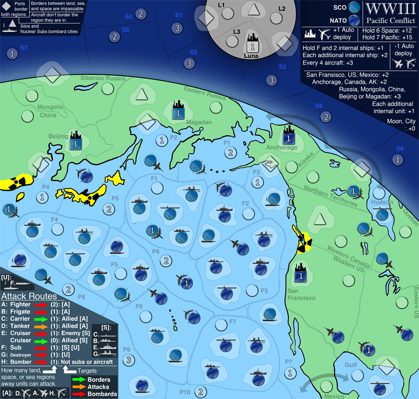
Newest Version:
Click image to enlarge.
image


Names for seemingly unnamed territories:
    The ships, subs, aircraft all have their names told in the legend, so according to that key, they will be named in the XML via "ocean, side, type" (e.g. F2 NATO Cruiser, or Western Canada SCO Bomber. Silos will also be named this way, but will not have an alliance: "Eastern Russia Silo." Ports will take the name for the land that they sit on: "Eastern US Port" or "L2 Port."

Newest Changes:
    Changes the current graphics colors to represent colors that are more natural and closer to what Earth looks like from space.
    The darker theme required white units (from black).
    Internal region cleanup (nicer borders).
    Moon territories shuffled around.
    Several territories added to space (satellites), no bonus associated with them yet (but there will be).
    Reordered the legends, got rid of the third legend (the two legends will probably be increased in size next version.

Concerns:
    The NATO and SCO circles are too similar.
    The current range calculations are unintuitive.
    The legend... obviously.

More territories are coming for the land areas.
Image
High: [Score 2660] [Rank 182] |
User avatar
Major initus
 
Posts: 96
Joined: Sat Jan 20, 2007 4:51 pm
Location: Incognito

Re: WWIII: Pacific Conflict (Updated 9/25/11, v8) *Vacation*

Postby initus on Sun Oct 09, 2011 10:34 pm

Going to have to put this one on vacation, this quarter's homework hit me pretty hard.
Image
High: [Score 2660] [Rank 182] |
User avatar
Major initus
 
Posts: 96
Joined: Sat Jan 20, 2007 4:51 pm
Location: Incognito

Re: WWIII: Pacific Conflict (Updated 9/25/11, v8) *Vacation*

Postby isaiah40 on Sun Oct 09, 2011 10:37 pm

Per mapmakers request, this has been put on vacation. When the time comes to have it moved back, post a new update and let one of the CA's know.

isaiah40
Lieutenant isaiah40
 
Posts: 3990
Joined: Mon Aug 27, 2007 7:14 pm


Return to Recycling Box

Who is online

Users browsing this forum: No registered users