Hey johloh, sorry i haven't checked in much lately.
Having finally finished off my map after much back and forth and going in circles, I feel like you're at that point in the game where the foundry-goers are running out of things to say in terms of improving your map, yet for one reason or another it isn't yet final-forge-ready. I feel your pain.
I'm staring at your map, and I have to say that the playability issues that have been raised have been largely addressed. A couple of little things bug me about the graphics...
First, everything looks a little "muddy" to me. It may be the color of the water that makes the entire map a bit unattractive. Marin and Contra Costa counties are both a kinda blah color as well... CC maps are usually a bit more lively, so that could be turning folks off.
Second, the dotted lines are starting to bug me a little, because they may not fit with the realism provided by the satelite image. I don't know what to do about it, and maybe they don't bother other people.
What was the last time we saw a small version?
San Francisco [Quenched]
Moderator: Cartographers
![]() by johloh on Sat Apr 07, 2007 1:44 am
by johloh on Sat Apr 07, 2007 1:44 am
oaktown...thanks for checking back in, i understand how youd want to take a break after finishing youre chinese checkers map...
Ill think about some of what you said, though i dont really know what to do about it...
Ill think about some of what you said, though i dont really know what to do about it...
never. i havent bothered, I figured that would mean I had to update two maps over and over again...I want to get to the point that im close to done with the large before I even bother with the small...What was the last time we saw a small version?
my new site - http://www.spritestitch.com/ - A video game craft weblog...
-

 johloh
- Posts: 472
- Joined: Mon Dec 04, 2006 12:58 pm
- Location: San Francisco


![]() by luckiekevin on Sat Apr 07, 2007 10:36 am
by luckiekevin on Sat Apr 07, 2007 10:36 am
I respectively disagree with Oaktown. I think that coloring this up to make it more "lively" would distract from the realism even more so than the dotted lines may as he suggests (even though I don't think they do).
This is my favorite map on CC because it is the most unique and doesn't have the overly contrasting bright colors that have sort of become a CC cliche'. The fact that it is taken from a satellite photo asks for some more subtle colors as it is realism that makes this map so wonderful..
Oaktown, I know you mean well, but I think you're grasping at straws here. I'm gonna play this map till the cows come home and I'm sure this is going to be one of the most popular maps on here.
-

luckiekevin
- Posts: 272
- Joined: Fri Oct 13, 2006 10:08 pm
- Location: California
![]() by Bad Speler on Sat Apr 07, 2007 10:39 am
by Bad Speler on Sat Apr 07, 2007 10:39 am
I must disagree with oaktown as well. However, i do agree on his point about the dotted lines, there does seem to be room for improvement there.
Highest Score: 2532
Highest Position: 69 (a long time ago)
Highest Position: 69 (a long time ago)
-
Bad Speler
- Posts: 1027
- Joined: Fri Jun 02, 2006 8:16 pm
- Location: Ottawa


![]() by duday53 on Sat Apr 07, 2007 10:44 am
by duday53 on Sat Apr 07, 2007 10:44 am
i think the map is great...probably the best graphics of all the maps, but oaktown needs a little work
lalaland wrote:This is what I love about Spamalot... you click on a title to a thread, and you have no idea what you'll find inside...
-

duday53
- Posts: 3046
- Joined: Thu Mar 08, 2007 6:57 pm
- Location: 1 hour north of Toronto, Ontario.

![]() by johloh on Sat Apr 07, 2007 10:48 am
by johloh on Sat Apr 07, 2007 10:48 am
now now...dont start coming down on oaktown...He was my personal east bay consultant and he helped a ton during the beginning and middle stages of development on this map...
the point about the dotted lines is interesting...I never even thought about it...any suggestions on how to change it? I dont think solid lines would look good, there needs to be a difference between the region borders, and ferry/bridge connection routes...
how can I make them match the realism of the satellite? im not sure...ideas?
my new site - http://www.spritestitch.com/ - A video game craft weblog...
-
johloh
- Posts: 472
- Joined: Mon Dec 04, 2006 12:58 pm
- Location: San Francisco
![]() by oaktown on Sat Apr 07, 2007 11:59 am
by oaktown on Sat Apr 07, 2007 11:59 am
duday53 wrote:i think the map is great...probably the best graphics of all the maps, but oaktown needs a little work
Thanks, duday. A quick search of the forums shows that your contribution to this and every other map has amounted to... absolutely nothing.
I love this map, and have from day one. Graphics are great, and having played USA one too many times I appreciate the earth tones. I just stared at it for a few minutes yesterday and found the water to be a bit mirky-looking... but then, I guess it accurately represents the bay water.
As for the ferry lines, they may never look like they were captured by the satelite image, but here's a suggestion (I'll write that big and slow for duday: SUG-GEST-ION). White is probably no good, as it looks like the borders, but maybe a blue to suggest a water route? And my boat is too big, but you get the idea... such a boat wouldn't fit all ferry routes, but if you made the ferry routes a standard color it would be clear what they are.

Last edited by oaktown on Sat Apr 07, 2007 12:37 pm, edited 1 time in total.
-

oaktown
- Posts: 4451
- Joined: Sun Dec 03, 2006 9:24 pm
- Location: majorcommand


![]() by oaktown on Sat Apr 07, 2007 12:34 pm
by oaktown on Sat Apr 07, 2007 12:34 pm
johloh wrote:I want to get to the point that im close to done with the large before I even bother with the small...
My concern is that when you create the smaller map, some territories - esp. the Fin. District - will be too small to hold your army circles (it's unfortunate that while the map gets smaller the army counts stay the same size). You may want to try scaling the file down to check this, as it would require redrawing the lines of the big map as well to keep them consistent.
Edit: here's a thought... what about losing the ferry lines entirely, and just make ferry ports? You'd need a line in the key saying "Ferry ports may attack each other and Alcatraz," and it would certainly impact play.
-
oaktown
- Posts: 4451
- Joined: Sun Dec 03, 2006 9:24 pm
- Location: majorcommand
![]() by EvilOtto on Sat Apr 07, 2007 5:54 pm
by EvilOtto on Sat Apr 07, 2007 5:54 pm
plysprtz wrote:i think down town should only be seven because if you take over richmond district it would only be 5 territories to hold it
and South SF can take either Burnal Heights or Inner Sunset to reduce it's borders, and Oakland can take El Cerrito to reduce it's borders.
I think Downtown will usually be taken late in the game (if at all), so that bonus seems okay to me (+7 would be cool though). I'm more concerned about the others... especially South SF as it can get down to three border territories pretty easily. To bad we can't make it +3.5!
Seems like we've been over all this before? Anyone remember what page?
-

EvilOtto
- Posts: 132
- Joined: Wed Dec 06, 2006 9:39 pm
- Location: San Francisco
![]() by Samus on Sat Apr 07, 2007 5:59 pm
by Samus on Sat Apr 07, 2007 5:59 pm
oaktown wrote:Edit: here's a thought... what about losing the ferry lines entirely, and just make ferry ports? You'd need a line in the key saying "Ferry ports may attack each other and Alcatraz," and it would certainly impact play.
I think johloh intentionally made the territories that can attack Alcatraz NOT border territories, so you can't just take it from the armies you would normally load up for defense anyway.
-

Samus
- Posts: 372
- Joined: Mon Jan 01, 2007 12:33 pm
![]() by Samus on Sat Apr 07, 2007 6:11 pm
by Samus on Sat Apr 07, 2007 6:11 pm
EvilOtto wrote:plysprtz wrote:i think down town should only be seven because if you take over richmond district it would only be 5 territories to hold it
and South SF can take either Burnal Heights or Inner Sunset to reduce it's borders, and Oakland can take El Cerrito to reduce it's borders.
I think Downtown will usually be taken late in the game (if at all), so that bonus seems okay to me (+7 would be cool though). I'm more concerned about the others... especially South SF as it can get down to three border territories pretty easily. To bad we can't make it +3.5!
Seems like we've been over all this before? Anyone remember what page?
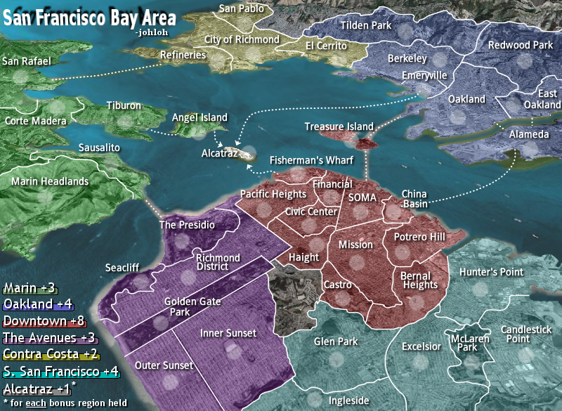
Applying the formula to these regions gets you:
Downtown 8.25
S. San Francisco 4.83
If you add the territories suggested and pretend they're just part of the regions (so +1 territory and -1 border), it comes out to:
Downtown 8.13
S. San Francisco 4.58
So not much change. Obviously being in a corner, S. San Francisco cannot be worth +5, so I think +4 is fine. Like you said, Downtown won't be taken until the end of most games anyway, so splitting hairs over +7 vs +8 will probably never matter in the majority of games.
-
Samus
- Posts: 372
- Joined: Mon Jan 01, 2007 12:33 pm
![]() by KEYOGI on Sat Apr 07, 2007 8:30 pm
by KEYOGI on Sat Apr 07, 2007 8:30 pm
I'm going to agree with some of the points made by oaktown. The colours are okay, they do the job, but I feel they could be nicer. Maybe they could even be toned down so we get a better feel for the city that lies under the colours.
The dotted connection lines aren't ideal either, and I think this is because they have no scale/depth. You have a satellite image as your map that provides a lot of depth to your image, but all your dots are the same size and seem to sit over the map rather than be a part of it. I guess you could say the same about some of the borders, but I think what you have done here works for the most part.
Your Oakland/Redwood Park border doesn't seem to quite make it all the way to the Berkeley border. There seems to be a bit of white on the edge of Outer Sunset, right next to its border with Golden Gate Park. There's a small part of the border between Bernal Heights and Glen Park that seems a little odd. I'm not sure if it's supposed to be a small bend, but it just looks like extra pixels.
Perhaps you could move the legend off the edge of the map, you have room to move it over a few pixels.
My major concern is your army shadows in Sausalito, Fisherman's Wharf, Financial and McLaren Park. The shadows seem to be touching borders in these territories, or at least very close to touching. I'm sure you could give them some more space, you're going to need it in the small version anyway.
-
KEYOGI
- Posts: 1632
- Joined: Tue Oct 10, 2006 6:09 am

![]() by luckiekevin on Sun Apr 08, 2007 10:39 am
by luckiekevin on Sun Apr 08, 2007 10:39 am
oaktown wrote:johloh wrote:I want to get to the point that im close to done with the large before I even bother with the small...
My concern is that when you create the smaller map, some territories - esp. the Fin. District - will be too small to hold your army circles (it's unfortunate that while the map gets smaller the army counts stay the same size). You may want to try scaling the file down to check this, as it would require redrawing the lines of the big map as well to keep them consistent.
Edit: here's a thought... what about losing the ferry lines entirely, and just make ferry ports? You'd need a line in the key saying "Ferry ports may attack each other and Alcatraz," and it would certainly impact play.
Then you're making it so that all ferry points attack each other which is not the way it works and it makes the gameplay more like 'king of the mountains". than the way it was worked out through endless debate here. You also take away the issue of not being able to attack out of alcatraz which has been worked on and worked out here to no end already. And you would be making all these sacrifices to game play because of graphic details. If you can find a way to do this with keeping the gameplay exactly the same, i say do it, but how?
-
luckiekevin
- Posts: 272
- Joined: Fri Oct 13, 2006 10:08 pm
- Location: California
![]() by johloh on Sun Apr 08, 2007 12:17 pm
by johloh on Sun Apr 08, 2007 12:17 pm
I believe I was previously told to decrease the transparency and make it brighter...I wanted it to be the faintest amount of color so you really could see the city...I'll post a version with higher transparency and see what people think now.Maybe they could even be toned down so we get a better feel for the city that lies under the colours.
Your Oakland/Redwood Park border doesn't seem to quite make it all the way to the Berkeley border. There seems to be a bit of white on the edge of Outer Sunset, right next to its border with Golden Gate Park. There's a small part of the border between Bernal Heights and Glen Park that seems a little odd. I'm not sure if it's supposed to be a small bend, butit just looks like extra pixels.
Perhaps you could move the legend off the edge of the map, you have room to move it over a few pixels.
My major concern is your army shadows in Sausalito, Fisherman's Wharf, Financial and McLaren Park. The shadows seem to be touching borders in these territories, or at least very close to touching. I'm sure you could give them some more space, you're going to need it in the small version anyway.
ill go through and try and fix it all...
that was supposed to be straight...ill fix it.and can you get the squiggle off the Market Street border? Other borders are straight - Market Steet actually IS straight.. well, except in the Castro.
my new site - http://www.spritestitch.com/ - A video game craft weblog...
-
johloh
- Posts: 472
- Joined: Mon Dec 04, 2006 12:58 pm
- Location: San Francisco
![]() by johloh on Sun Apr 08, 2007 12:19 pm
by johloh on Sun Apr 08, 2007 12:19 pm
ill try and post a new version today...and after I fix all of those minor problems I'll try and make a small version...
my new site - http://www.spritestitch.com/ - A video game craft weblog...
-
johloh
- Posts: 472
- Joined: Mon Dec 04, 2006 12:58 pm
- Location: San Francisco
![]() by johloh on Sun Apr 08, 2007 5:20 pm
by johloh on Sun Apr 08, 2007 5:20 pm
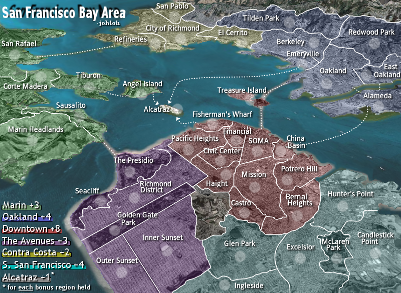
changes...
-extended oakland/redwood border to reach berkeley
-fixed outer sunset border near water/gg park
-took out smudge in bernal/glen border
-moved legend 3 pixels off edge (i think its centered with the map edge now)
-straightened market street (civic/financial/SOMA border)
-changed sausalito border to give the army circle more room
-moved fishermans wharf border to give army circle more room
-increased financial border to give army circle more room
-moved mclaren park border and recentered army circle
-fixed mess up on SOMA and china basin border
my new site - http://www.spritestitch.com/ - A video game craft weblog...
-
johloh
- Posts: 472
- Joined: Mon Dec 04, 2006 12:58 pm
- Location: San Francisco
![]() by johloh on Sun Apr 08, 2007 5:24 pm
by johloh on Sun Apr 08, 2007 5:24 pm
some different options to peruse...previous post was normal, here are three options with a more transparent color on top...
one step lighter

two steps lighter
three steps lighter
one step lighter
two steps lighter
three steps lighter
my new site - http://www.spritestitch.com/ - A video game craft weblog...
-
johloh
- Posts: 472
- Joined: Mon Dec 04, 2006 12:58 pm
- Location: San Francisco
![]() by johloh on Sun Apr 08, 2007 5:25 pm
by johloh on Sun Apr 08, 2007 5:25 pm
next update - small map version
my new site - http://www.spritestitch.com/ - A video game craft weblog...
-
johloh
- Posts: 472
- Joined: Mon Dec 04, 2006 12:58 pm
- Location: San Francisco
![]() by luckiekevin on Sun Apr 08, 2007 5:56 pm
by luckiekevin on Sun Apr 08, 2007 5:56 pm
The more steps lighter, the worse it looks in my opinion. It just likes like something that has been sun bleached over time. I like it the way it is.
-
luckiekevin
- Posts: 272
- Joined: Fri Oct 13, 2006 10:08 pm
- Location: California
![]() by johloh on Sun Apr 08, 2007 6:02 pm
by johloh on Sun Apr 08, 2007 6:02 pm
I agree...I dont mind the first step lighter...but the other 2 are bad I think...
my new site - http://www.spritestitch.com/ - A video game craft weblog...
-
johloh
- Posts: 472
- Joined: Mon Dec 04, 2006 12:58 pm
- Location: San Francisco
![]() by AndyDufresne on Sun Apr 08, 2007 10:23 pm
by AndyDufresne on Sun Apr 08, 2007 10:23 pm
- Final Forge
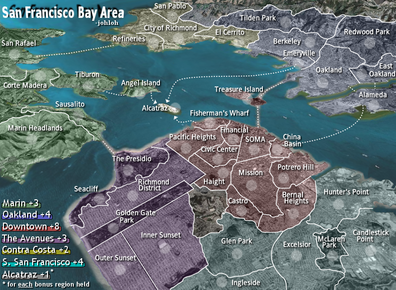
---The San Francisco Bay Map has reached the ‘Final Forge’ Stage. I've revived this thread from the pits of the Foundry furnace and have examined the contents. Nearly every major concern has been addressed. If there are any other current concerns, please make your voice heard. There will be at least two days (but may extend pass that) for you to post any objections; if no one has posted any protest after two days the map will be deemed finished with the 'Foundry Brand' of approval and will be submitted for live play. If after two days there is still discussion going on it may continue until said discussion has reached the conclusion that the map has reached its final and polished version.
Post questions and concerns if any.
--Andy
-

AndyDufresne
- Posts: 24935
- Joined: Fri Mar 03, 2006 8:22 pm
- Location: A Banana Palm in Zihuatanejo


![]() by oaktown on Mon Apr 09, 2007 1:38 am
by oaktown on Mon Apr 09, 2007 1:38 am
final forge - congrats, johloh!
I was flying out of Oakland today, and I have to admit that the color of the bay was damned close to what you have on this map... actually, your map makes the bay water look better.
Let's see that small map with army circles and counts.
I was flying out of Oakland today, and I have to admit that the color of the bay was damned close to what you have on this map... actually, your map makes the bay water look better.
Let's see that small map with army circles and counts.
-
oaktown
- Posts: 4451
- Joined: Sun Dec 03, 2006 9:24 pm
- Location: majorcommand
Who is online
Users browsing this forum: No registered users
|
|||||||
| Conquer Club is not associated with RISK online in any way. Copyright © 2006-2025 by Big Wham LLC | |||||||