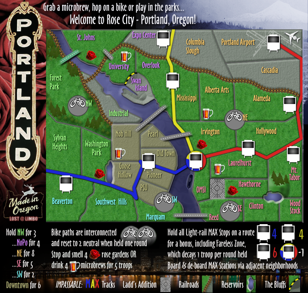
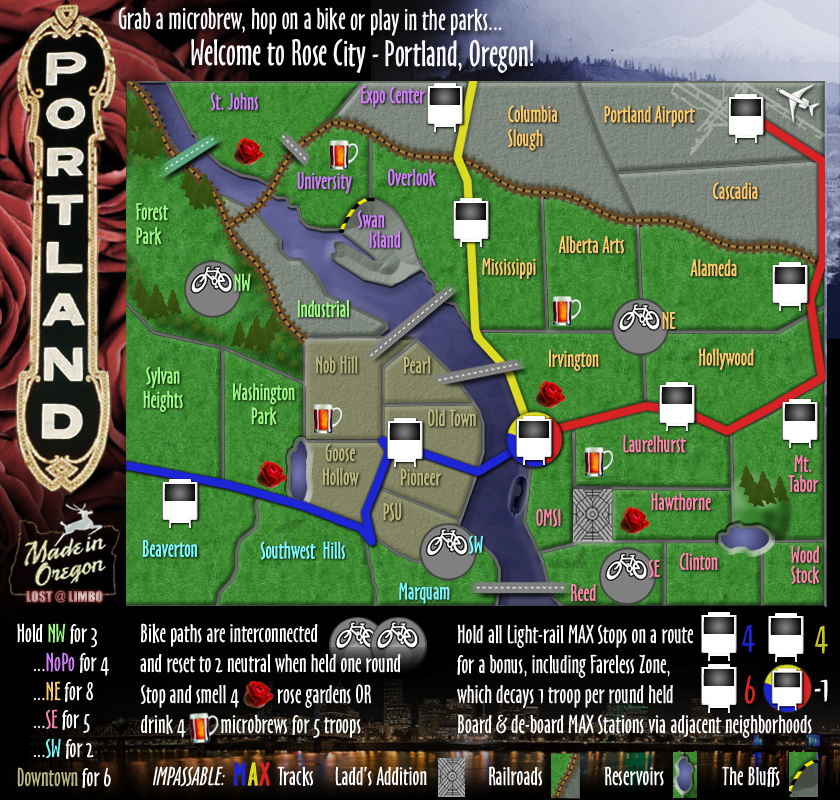
TotoroHat wrote:I am Still glad to see this map is still in the works. I have a few suggestions which I will post below. But first the Geography on the map is not accurate... Change Clinton to Wood Stock and Change Wood Stock to either Lents or Mount Scott and remove Clinton all together! The Clinton Neighborhood is between Gladstone and Hawthorne. (Gladstone being north of Reed) and Wood Stock is east of Reed. There is no room for Clinton... (REED takes up at least 7 neighborhoods on this map lol when it itself is very Small) I would say Name it Sellwood but I think the Map needs the Reed Name so keep it.
Anywhoo thats not a big concern but here are some suggestions,
1. The Max line goes to Clackamas Town Center (Wood Stock on this map) maybe you can include it!
2. It is hard to tell certain regions apart.... suggest make them a different color (not just the names a different color) This goes for the Max Lines as well.
3. make the bikes killer neutrals (say +2 and reset to +2 or +6 with no Reset.... something like that (we may love our bikes but even with the east Bank Esplinade ... Reed to Forest park is still an hour away).
Do you cross the Max lines at the Max Cars or how does that work... might confuse some people
Awesome Map.... Keep up the good work!
Hi Totoro - thanks for you input & feedback
Much of the map is not geographically accurate. The entire eastside was squished down (red MAX should be another 3 inches off the map) and Downtown was magnified more than double its true size. That said, you make some valid, but debatable points.
My benchmark for naming each territory was not official neighborhood names, but general areas that people refer to. Like the Alberta area, Clinton is often referred to beyond its official boundaries because it is a 'place to go'. The official Clinton neighborhood may be smaller than shown, but it is indeed just south of Mt. Tabor & Hawthorne, as the map shows.
Woodstock is a similar case. I never hear anyone talk about Lents in Portland. Colloquially, Woodstock has come to encompass a larger area. More accurately, it would be Foster-Powell, but that doesn't quite roll off the tongue. Early on in the map, I was referring to it as Mt. Scott, but that seemed redundant with Mt. Tabor, so I opted for Woodstock instead. I still prefer that, and I'll note that Woodstock Blvd crosses through that area all the way to I-205.
Reed v Sellwood is a toss up. Both have their merits, but Reed wins based on size - Sellwood just isn't going to fit in that space! :)
As for the Clackamas Town Center - I've avoided including structures here. You'll notice the Llyod Center is also absent. There is a vague reference to the Rose Garden arena, but only as it fits in with the rest of the map. My goal with this map was to highlight the things I appreciate or find unique about Portland (copious public parks, robust transit & bike network, bridges, beer, etc). An enormous shopping mall doesn't really fit in with all that. I also started this map before the Green line was in use. I thought about adding it, but there's just not enough space.
Also, FYI, the bike lanes are indeed 2 killer neutral each. (So 4 neutral to get anywhere). Biking does take work (though less so than a place like San Francisco!) but these are bike paths.
At any rate, I appreciate your attention to detail and that you took the time to make these suggestions.


