'k, thanks, good to know, I just wondered what it was referring to. Sorry I didn't look deeper into this thread to see where else you mentioned it.shakeycat wrote:Leehar -
I'm just working through that one at the moment. I realized I hadn't actually written that into the XML, so currently, no such bonus applies.
Northwest Passage [Quenched]
Moderator: Cartographers
Forum rules
Please read the Community Guidelines before posting.
Please read the Community Guidelines before posting.
Re: Northwest Passage [Mar 30]
Spoiler
Re: Northwest Passage [Apr 2]
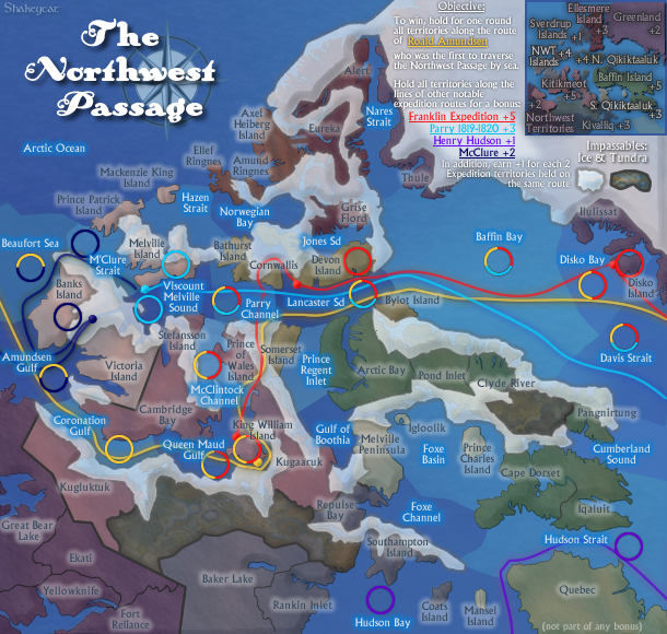
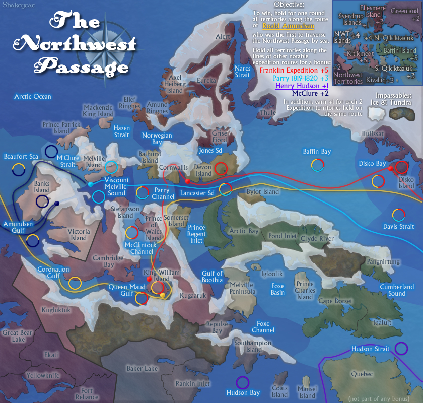
Graphics updated: tweak to minimap and Queen Maud/Coronation border.
XML UPDATED: +1 for 2 expedition territories is now included!

http://www.atomation.com/~thazzard/fun/nwp/nwpass.xml
XML UPDATED: +1 for 2 expedition territories is now included!

http://www.atomation.com/~thazzard/fun/nwp/nwpass.xml
Current Map Project: Tokyo
Re: Northwest Passage [Apr 2]
Game 8816354
shouldn't be Nares Strait and Baffin Bay connected ?!?
shouldn't be Nares Strait and Baffin Bay connected ?!?
De gueules à la tour d'argent ouverte, crénelée de trois pièces, sommée d'un donjon ajouré, crénelé de deux pièces
Gules an open tower silver, crenellated three parts, topped by a apertured turret, crenellated two parts
Gules an open tower silver, crenellated three parts, topped by a apertured turret, crenellated two parts
Re: Northwest Passage [Apr 2]
They should be - I'm just waiting for the XML to be updated so they are! In the meantime, you'll have to go through Thule.
Current Map Project: Tokyo
Re: Northwest Passage [Apr 2]
i`ll apologize first , usually i try to be positive when posting in a map thread but this map will be different. when i view this map it looks like a cluster **** . the water having different shades and the land mass colors just dont work.. the mishmash results in no depth to the map. i find myself staring real hard just to figure out what connects to what.. And then to boot theres these squigly lines running through the map.. although some of these lines have definitive points there are many that are not quite clear...
Re: Northwest Passage [Apr 2]
It's a bit of an unconventional map. We figured the differing colours of water would be a cleaner effect than bright borderlines all over the place. The army circles are ringed with the colours of the routes running through them, to make it clearest which territories are affected by what routes.
The land-water connections seem the most difficult - things like Cambridge Bay to Viscount Melville, Kugaruuk in general. Look hard, there are no surprises. The more you play, the more sense it'll make. There are no minimaps or teleports; it's all out in the open.
I'm not really sure how I could execute a "Northwest Passage" map without these elements. Without the ice, there would be too many borders on most territories, and an unreal sense of accessibility. Without the routes, it isn't really the passage - and the objective works! You can't just have land with connections between the islands like ferry boats, because it isn't about capturing land. Nor can it be water alone, because everything would funnel at Lancaster. You really can't get through the Melville Peninsula, or take your boat north through Nares.
We've had more than a year to look over the map and find a way to do it better, which is longer than most maps take! At this stage, it feels there isn't too much that can be done to make it into a blatantly straightforward, easy map like Charleston. It's not a simple concept.
Current Map Project: Tokyo
Re: Northwest Passage [Apr 2]
The only thing I found confusing about the map, was that the routes didn't connect along the coloured lines.
Re: Northwest Passage [Apr 2]
Game 8787755
I have 2 territories on the Parry route (Melville Island + sound), but I don't get my +1 bonus for 'each 2 Expedition territories held on the same route'.
Is this XML or legend clarity? I would clearly expect to get a bonus with those two territories held.
I have 2 territories on the Parry route (Melville Island + sound), but I don't get my +1 bonus for 'each 2 Expedition territories held on the same route'.
Is this XML or legend clarity? I would clearly expect to get a bonus with those two territories held.
Re: Northwest Passage [Apr 2]
I am currently waiting for the XML to be updated with this fix.
Current Map Project: Tokyo
Re: Northwest Passage [Apr 2]
The updated images and xml have been forwarded to the turtle 

PB: 2661 | He's blue... If he were green he would die | No mod would be stupid enough to do that
Re: Northwest Passage [Apr 2]
and the turtle is going his pace
step by ... step
step by ... step
De gueules à la tour d'argent ouverte, crénelée de trois pièces, sommée d'un donjon ajouré, crénelé de deux pièces
Gules an open tower silver, crenellated three parts, topped by a apertured turret, crenellated two parts
Gules an open tower silver, crenellated three parts, topped by a apertured turret, crenellated two parts
Re: Northwest Passage [Apr 2]
Nares Strait attacks Baffin Bay, but
Baffin Bay can't attack Nares Strait
Baffin Bay can't attack Nares Strait
Re: Northwest Passage [Apr 2]
It looks like the Nares Strait / Baffin Bay border has been corrected as of about five hours ago. Flush your cache and reload the game page, uckuki, and if you still have a problem, report back here.
Re: Northwest Passage [Apr 2]
Wow - yes, the +1 for 2 is working too! Bonuses galore. Thanks lack, MrBeen, Nobodies. 
Current Map Project: Tokyo
- MarshalNey
- Posts: 781
- Joined: Mon Sep 28, 2009 9:02 pm
- Gender: Male
- Location: St. Louis, MO
Re: Northwest Passage [Apr 2]
I was talking in a doubles game with my good-natured opponents and they had almost convinced me that 2 neutrals for all sea regions, including the expedition routes, might be a desirable thing.
Then the update went through and I'm convinced you did the right thing making them 3 neutrals. My bonuses are rather large now
My oppenents (not using BOB or the large map) thought that a higher contrast for the region names on the land would help a lot, as one of them was having some difficulty reading them.
Love, love, love this map, thank you Shakeycat! (btw the opposing team likes it too)
-- Marshal Ney
- ironsij0287
- Posts: 379
- Joined: Tue Nov 09, 2010 2:30 pm
- Gender: Male
- Location: Dubuque
Re: Northwest Passage [Apr 2]
Been in a game for over a week now and still don't understand where the bonus regions lie or what can attack what. 
Re: Northwest Passage [Apr 2]
This map is as clear as mud.
- Victor Sullivan
- Posts: 6010
- Joined: Mon Feb 08, 2010 8:17 pm
- Gender: Male
- Location: Columbus, OH
- Contact:
Re: Northwest Passage [Apr 2]
Obviously you have issues with this map on some level, but there's no way for the mapmaker to know what needs clarified. Care to explain further your concerns?napientek wrote:This map is as clear as mud.
Beckytheblondie: "Don't give us the dispatch, give us a mustache ride."
Scaling back on my CC involvement...
Scaling back on my CC involvement...
Re: Northwest Passage [Apr 2]
The only thing I found a bit confusing, was that you can't attack along the routes.
Re: Northwest Passage [Apr 2]
You can, it just isn't laid out in a subway-style, nor does it sit above the board like a train system would. Perhaps if I had used dotted lines that would've been more clear? But all the territories along a route do connect. (and I don't think my Fireworks MX does dashed lines, or you might've seen them)Riskismy wrote:The only thing I found a bit confusing, was that you can't attack along the routes.
Current Map Project: Tokyo
Re: Northwest Passage [Apr 2]
hm. Odd. I coulda sworn there was two that didn't connect. Probably i was just in a hurry. My mistake.
Re: Northwest Passage [Apr 2]
It seems to me that the places where expedition bonuses are doubled or tripled up (Lancaster, Baffin, Parry, Davis) are rather easy to conquer at just 3 neutrals. Bust 12 neutrals, get +6 bonus. Should the neutrals be raised slightly - perhaps 4 where there's 2 routes running through, and 5 where there's 3? More? No?
Current Map Project: Tokyo
- natty dread
- Posts: 12877
- Joined: Fri Feb 08, 2008 8:58 pm
- Location: just plain fucked
Re: Northwest Passage [Apr 2]
Adding neutrals will likely just make them be ignored. Also, the map is not very open, high neutrals will constrain the gameplay even more... I would advise against it.
The +6 bonus for 12 neutrals is not so bad, considering you have to defend 4 borders to keep it.
The +6 bonus for 12 neutrals is not so bad, considering you have to defend 4 borders to keep it.

Re: Northwest Passage [Apr 2]
Okay, just thought I'd put it out there  I don't want to feel like I'm taking advantage of a flaw in the gameplay currently!
Current Map Project: Tokyo
Re: Northwest Passage [Apr 2]
The Hudson terr. are now worth +4, was that your intention with the extra +2 per 2 exp. terr or do you think that bonus could use some adjusting?


