Moderator: Cartographers
Tisha wrote:sailorseal wrote:Just three quick things because I love this map
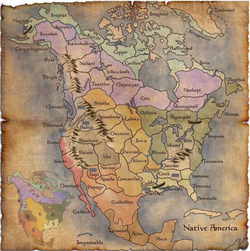
1. Get rid of the compass it does not fit with the map
2. Either capitalize the names or don't but don't have it random
3. Add more canoes because that river really divides the map and only one looks odd
i like the compass.... why doesn't it fit?
all the names are capitalized, it's the font i'm using. (that i love)
Tisha wrote:sailorseal wrote:2. Either capitalize the names or don't but don't have it random
all the names are capitalized, it's the font i'm using. (that i love)
Ruben Cassar wrote:
I have a problem with more than one region actually. Aren't Pomo and Paiute part of the same region?
Ruben Cassar wrote:Very nice map indeed Tisha. Well done!
However I must say that I have a big problem with the colours used. It is very hard for me to differentiate between a region and another.
Also would it be possible to have a mini map instead of just listing the various regions?
MrBenn wrote:Some of your colours are very similar (the red/orange and blue/purple), and I think there needs to be a bit more clarity between the regions - which don't all have tentative bonus values yet
ghirrindin wrote:Given that the tribes in each of your territories represent a striking array of cultural diversity, perhaps geographic names would be best for the territories? Arctic, Sub-Arctic, Plains, Pacific Northwest, Central Pacific, Great Basin, Southwest, Mesoamerica, Southeast, and Eastern Woodlands? I'm at a loss of what to call that two region territory in the mountains. Columbia River Plateau?
Hope this helps!
thenobodies80 wrote:Yes, there were some problem with colors on names, but the names fit better than this minimap...a turn back and trying with a different use of colors?
I'm with Tack (about northern/Eastern regions), a split could be a good choice.
The gameplay is unbalanced now, the south and the west zones are still good places in which a player could start, the north and the east zones aren't holdable.
TNBDS
Danyael wrote:vey nice looking map
I'm a big fan of your burnt edges really suits the map
it looks kinda pretty sharp at the top left corner maybe blur it but not a big deal
I think that Ojibwa needs to go further west with its border
they where nomadic for buffalo hunts threw out the canadian prairies
maybe have it at least more west of lake manitoba due dakota ojibawa resevr is around there as well as sacred ojibawa grounds near portage la praire
as well on a side note lake manitoba is bigger then winnipeg
where is a link to a site on ojibwa in case you want to read alittle about them
http://www.native-art-in-canada.com/ojibwaindians.html
and here's a bad pic where ojibwa are still present an have reserve and scared lands in these location and a purpose border for them
not a must but some to keep in mind
once again very nice looking map and the mini map make so there is no confusion with my colourblindness
oaktown wrote:For starters, this map is all kinds of nice. It's my favorite looking map in the Drafting Room right now.
That said, it turns out I have a lot of little critiques. For starters, the glow around the mountains flows nicely with some region colors (the south east), and creates a bit too much contrast with others (especially California). And while the mini-map helps immensely in terms of picking out where the regions are, the colors on the map are close enough to confuse color-blind players (like me). The colors of northern and southern mexico are especially close.
i'll have to change all the colors.. i'll figure it out
Has there been any thought of making Coahuiltec a part of the Mesoamerica bonus? +2 for three territories that are only accessible from one region/territory seems quite generous - adding Coahuiltec and leaving it a +2 makes it an Australia and makes it more in line with the Califoria +2.
What if i split Coahuiltec into two? then i could take a territory out somewhere else.. that will only make the s. w. harder to hold then though.
And now that I look at the regions more closely, it's too bad all of the good starts/small bonuses are clustered. Two-thirds of the map will be completely ignored for the decisive first few rounds of most games. I'd say that the first player to hold a bonus - which will probably be the little guy - will be able to harass the other players trying to hold their first bonuses and/or expand to hold more. And I haven't crunched any numbers, but the pacific northwest/inside passage region seems generous, considering the South East gets only one extra army and it has eight territories and four borders, compared to four territories with four borders. And when you start coupling the small regions you get all kinds of generous bonuses: +5 for five territories with three borders, for example.
Forgive me if this has been brought up, but I'm wondering how people feel about the map title? The term "Native American" is most commonly used to describe people who are native to the United States, and this map goes beyond US borders. And you can most certainly use the term to describe anyone native to the Americas, but that would also include South America. Plus, any name using the word America suggests European presence, since America is itself a name given to the land by Europeans.
The ideal title for this map would be something not derivative of a European name. Our Canadian friends use the terms "First Nations" to refer to native peoples, which is far more empowering.
First Nations i kinda like
MrBenn wrote:On an a side-note, as a child I used to have a recurring nightmare about being chased round a supermarket by a crocodile pushing a shopping trolley and wearing an "I ♥ Shopping" t-shirt...
Merker wrote:Just one thing about the name...It's just that I have this feeling that if map was Native America, it'd include South America, so please, just for me, change the name of the map to Native North America / North Native America, thanks, .
lt_oddball wrote:couldnt you change the very very english name "yellowknife" into "Athabascans" ?
Technically, the yellowknife for todays reference is correct, but it looks bad on this map amongst all original indian names.
I googled, and found Athabascans as (larger group)alternative.
The same goes for "Copper".
Look for something more appropriate.
Tisha wrote:thenobodies80 wrote:Yes, there were some problem with colors on names, but the names fit better than this minimap...a turn back and trying with a different use of colors?
I'm with Tack (about northern/Eastern regions), a split could be a good choice.
The gameplay is unbalanced now, the south and the west zones are still good places in which a player could start, the north and the east zones aren't holdable.
TNBDS
i'm going to have to mess with the colors.. i don't like the minimap either..
why isn't the east holdable? 8 territories 4 borders, 9 territories 4 borders
as for the north.. i mentioned less territories, maybe trees as an impassable?
oaktown wrote:
Forgive me if this has been brought up, but I'm wondering how people feel about the map title? The term "Native American" is most commonly used to describe people who are native to the United States, and this map goes beyond US borders. And you can most certainly use the term to describe anyone native to the Americas, but that would also include South America. Plus, any name using the word America suggests European presence, since America is itself a name given to the land by Europeans.
The ideal title for this map would be something not derivative of a European name. Our Canadian friends use the terms "First Nations" to refer to native peoples, which is far more empowering.
MrBenn wrote:On an a side-note, as a child I used to have a recurring nightmare about being chased round a supermarket by a crocodile pushing a shopping trolley and wearing an "I ♥ Shopping" t-shirt...
Merker wrote:oaktown wrote:
Forgive me if this has been brought up, but I'm wondering how people feel about the map title? The term "Native American" is most commonly used to describe people who are native to the United States, and this map goes beyond US borders. And you can most certainly use the term to describe anyone native to the Americas, but that would also include South America. Plus, any name using the word America suggests European presence, since America is itself a name given to the land by Europeans.
The ideal title for this map would be something not derivative of a European name. Our Canadian friends use the terms "First Nations" to refer to native peoples, which is far more empowering.
Or you could call it Amerigine. Though it would probably mistaken some sort of precious metal map.
Tisha wrote:as for the north.. i mentioned less territories, maybe trees as an impassable?
sailorseal wrote:come on, now i am all sticky
Users browsing this forum: No registered users