This is better than the inset.MrBenn wrote:OK, here's another (quick) update...
The London inset has gone - instead I have added London as a small territory that will border Kent, Essex, Middlesex and Surrey. The circle looks a little blurry, but I'll sort that out if people think this idea works better.
I have added some lines to show where London, Rutland and Isle of Wight go.
England Map [Quenched]
Moderator: Cartographers
Forum rules
Please read the Community Guidelines before posting.
Please read the Community Guidelines before posting.
-
Ruben Cassar
- Posts: 2160
- Joined: Thu Nov 16, 2006 6:04 am
- Gender: Male
- Location: Civitas Invicta, Melita, Evropa
Re: England Map [D] - Lions p1/9


Re: England Map [D] - Lions p1/9
Bumping image onto the latest page 


PB: 2661 | He's blue... If he were green he would die | No mod would be stupid enough to do that
-
the.killing.44

- Posts: 4724
- Joined: Thu Oct 23, 2008 7:43 pm
- Gender: Male
- Location: now tell me what got two gums and knows how to spit rhymes
- Contact:
Re: England Map [D] - Lions p1/9
I'd like to see London with army numbers on it.
.44
.44
Re: England Map [D] - Lions p1/9
The number will go after the name: "London 88"
PB: 2661 | He's blue... If he were green he would die | No mod would be stupid enough to do that
-
the.killing.44
- Posts: 4724
- Joined: Thu Oct 23, 2008 7:43 pm
- Gender: Male
- Location: now tell me what got two gums and knows how to spit rhymes
- Contact:
Re: England Map [D] - Lions p1/9
Good one.MrBenn wrote:The number will go after the name: "London 88"
.44

Re: England Map [D] - Lions p1/9
Agreed - although I could completely leave it off too...Ruben Cassar wrote:This is better than the inset.MrBenn wrote:OK, here's another (quick) update...
The London inset has gone - instead I have added London as a small territory that will border Kent, Essex, Middlesex and Surrey. The circle looks a little blurry, but I'll sort that out if people think this idea works better.
I have added some lines to show where London, Rutland and Isle of Wight go.
C.

Highest score : 2297
-
The Chosen

- Posts: 328
- Joined: Thu Apr 19, 2007 10:21 am
- Gender: Male
- Location: Halfway up the stairs. (2287 = 447th)
- Contact:
Re: England Map [D] - Lions p1/9
Mr Benn,
Being a Postman and a life-long Englishman from the City and County of Bristol (erm... not represented here), I would like to commend you on your excellent map. I have a few issues/suggestions however;
1. Middlesex should be shortened to Middx (not Midx)
2. The bonus system is hard to understand - could it not be simplified to a straight "hold the region - get the bonus"?
3. London absolutely has to have a major presence on a map of England. Here is a link to a map of England's Regions...
http://www.picturesofengland.com/mapofe ... gions.html
... as you can see London is massive (not a little dot) and maybe should replace Middlesex as a territory on your map.
4. If it was represented I think it should start as a neutral and be given a +1 bonus for holding it (or maybe +1 auto deploy)
5. Gloucestershire could be shortened to Glos or Glous
6. The tail of Gloucestershire where it borders Somerset could be cut off and changed to Bristol.
7. Isle of Wight needs to have a line connecting it to Hampshire (for clarity)
8. The three lions are great and the water effect is magnificent.
Keep up the good work and I hope the above helps.
TC.

IF WE EVOLVED FROM APES... WHY ARE THERE STILL APES?
-
gimil

- Posts: 8599
- Joined: Sat Mar 03, 2007 12:42 pm
- Gender: Male
- Location: United Kingdom (Scotland)
Re: England Map [D] - Lions p1/9
From what I know the rampant lion was a symbol of the scottish kingdom was it not?Ruben Cassar wrote:Is the single rampant lion a symbol of England? I think other countries and states have used it through the ages.
- Click image to enlarge.

The Royal Standard of Scotland, also known as the Royal Standard of the King of Scots or more commonly the Lion Rampant, is the Scottish Royal banner, and its correct use is restricted to only a few Great Officers who officially represent The Sovereign.[1] The banner of the Royal coat of arms of the Kingdom of Scotland, it was used historically by the King of Scots until the Union of the Crowns in 1603.
What do you know about map making, bitch?
Top Score:2403natty_dread wrote:I was wrong


Re: England Map [D] - Lions p1/9
MrBenn wrote:The number will go after the name: "London 88"
perhaps an army circle in the middle of the meeting-place of middlesex, essex, kent and surrey, with pointers to these four adjacent counties, similar to the max stations in lostatlimbo's rose city map, will suit.The Chosen wrote:London is massive (not a little dot)
http://www.conquerclub.com/forum/viewto ... 75&start=0
ian.

Re: England Map [D] - Lions p1/9
I'm actually thinking about taking London off the map again - having it as a little dot/inset doesn't really fit the theme of the map 
PB: 2661 | He's blue... If he were green he would die | No mod would be stupid enough to do that
Re: England Map [D] - Lions p1/9
TBH - I think I concur about that.MrBenn wrote:I'm actually thinking about taking London off the map again - having it as a little dot/inset doesn't really fit the theme of the map
C.
Highest score : 2297
Re: England Map [D] - Lions p1/9
Right, so here's another update...
London has gone, primarily because it didn't really work as an inset or a small dot. I'll stick with the "historic counties" theme
Huntingdonshire has emerged from the shadow of Cambridgeshire
I've jiggled around with territory names, placements, and added some nice army shadows and numbers.
I think I'm settled with the three lions now - I'm also planning to keep the 'Green and Pleasant Land' subtitle. The eagle-eyed may notice the opening lines of Land of Hope and Glory skirting along the western edge of the map
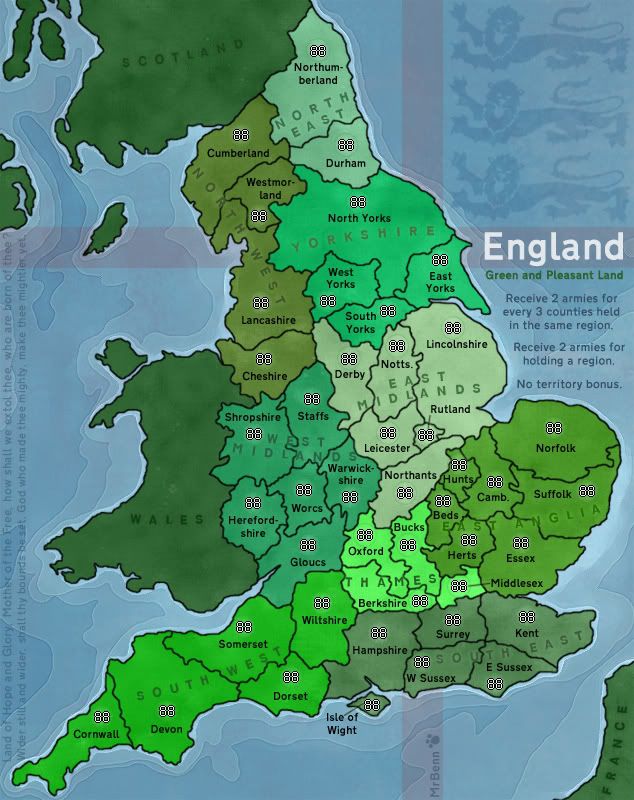
What next? The future is in your hands!
London has gone, primarily because it didn't really work as an inset or a small dot. I'll stick with the "historic counties" theme
Huntingdonshire has emerged from the shadow of Cambridgeshire
I've jiggled around with territory names, placements, and added some nice army shadows and numbers.
I think I'm settled with the three lions now - I'm also planning to keep the 'Green and Pleasant Land' subtitle. The eagle-eyed may notice the opening lines of Land of Hope and Glory skirting along the western edge of the map
What next? The future is in your hands!
PB: 2661 | He's blue... If he were green he would die | No mod would be stupid enough to do that
-
LED ZEPPELINER
- Posts: 1088
- Joined: Tue Nov 25, 2008 10:09 pm
Re: England Map [D] - Update Mar 12th - p1/11
the 88's on bucks and oxford are way off of the army circles, and i like it better without army circles
Re: England Map [D] - Update Mar 12th - p1/11
^^Refresh your browser
PB: 2661 | He's blue... If he were green he would die | No mod would be stupid enough to do that
-
the.killing.44
- Posts: 4724
- Joined: Thu Oct 23, 2008 7:43 pm
- Gender: Male
- Location: now tell me what got two gums and knows how to spit rhymes
- Contact:
Re: England Map [D] - Update Mar 12th - p1/11
Surrey - Kent - E Sussex - W Sussex; what's happening there?
And I still stand by my statement that when you post a small v you get the GFX stamp. 'Course the key word there is my, but that's beside the point … this is beautiful.
.44
And I still stand by my statement that when you post a small v you get the GFX stamp. 'Course the key word there is my, but that's beside the point … this is beautiful.
.44
Re: England Map [D] - Update Mar 12th - p1/11
I need to redraw that border. My base image had all four counties meeting at one point, but there's a very slight offset, where East Sussex borders Surrey as well as Kent. West Sussex does not border Kent.the.killing.44 wrote:Surrey - Kent - E Sussex - W Sussex; what's happening there?
I'll clarify this in the next update.
PB: 2661 | He's blue... If he were green he would die | No mod would be stupid enough to do that

Re: England Map [D] - Update Mar 12th - p1/11
I know you want to stick to the historic counties theme, but a possible solution to the North East drop problem would be to include either a Tyneside/Tyne and Wear or a Teesside "county"? Or maybe Cleveland at the South-East corner of Durham?
Important Tournament Notice
The data for ALL of my tournaments has potentially been lost. I am working to recover it but as I am away on business all of this week, there will be some delay. Sincere apologies.
The data for ALL of my tournaments has potentially been lost. I am working to recover it but as I am away on business all of this week, there will be some delay. Sincere apologies.
Re: England Map [D] - Lions p1/9
so that leaves only yorkshire with non-traditional post-1974 borders instead of the original ridings! any chance of finishing the job?MrBenn wrote:I'll stick with the "historic counties" theme
http://www.yorkshire-ridings.org.uk/
http://www.chromavision.co.uk/yt/map.htm
good decision on the lions! the rousing, flag-waving land of hope and glory conveys a completely different picture of england from the peaceful green and pleasant land tagline. how would it look with the following four lines on the left instead?MrBenn wrote:I think I'm settled with the three lions now - I'm also planning to keep the 'Green and Pleasant Land' subtitle. The eagle-eyed may notice the opening lines of Land of Hope and Glory skirting along the western edge of the map
I will not cease from mental fight
Nor shall my sword sleep in my hand
Till we have built Jerusalem
In England's green and pleasant land
this is a good point. in particular, the "receive 2 armies for holding a region" bonus will tend to send players scurrying to the corners to seek out the easiest regions to hold, with the midlands being neglected.The Chosen wrote:The bonus system is hard to understand - could it not be simplified to a straight "hold the region - get the bonus"?
ian.
-
thenobodies80

- Posts: 5401
- Joined: Wed Sep 05, 2007 4:30 am
- Gender: Male
- Location: Milan
Re: England Map [D] - Update Mar 12th - p1/11
Can you rotate the WEST MIDLANDS word?
You a have a lot of space in the lower part of Shropshire.
In a similar angle shot of East Midlands
Wonderful map
You a have a lot of space in the lower part of Shropshire.
In a similar angle shot of East Midlands
Wonderful map
-
GenuineEarlGrey

- Posts: 176
- Joined: Thu May 01, 2008 1:30 am
Re: England Map [D] - Lions p1/9
I played British Isles I when I started on CC and was amused at the "Granpiam" region. I had this image of all scottish grandmothers living there. Its since been corrected to "Grampian" in British Isles II but at the end of the day the little quirk made no difference to what was a really good map.
England is shaping up the same way. [Sorry for joining in the forum so late.] A great map with a little quirk - should Yorkshire be split into three (North, East and West based on the Ridings] or four (North, South, East and West) tets.
The quirk can be circumvented [my, big word for a Monday morning]. I'm not sure whether iancanton is suggesting going to three or sticking with four tets with new names. Either way a win-win sitiation is there.
While I prefer the three [BUT I'm not the one taking the time to make the map] the map can still have four York tets and keep its "historic counties" theme by using four other traditional names for the tets: Yorkshire Dales; Yorkshire Moors; West Yorkshire; East Yorkshire. If you want perfection then there would need to be a small border change as mentioned in ian's link http://www.chromavision.co.uk/yt/map.htm
All the best, E.G.
Re: England Map [D] - Lions p1/9
i have in mind either the three ridings alone or, if an extra territory is desired, the three ridings plus the city of york in the middle.GenuineEarlGrey wrote:A great map with a little quirk - should Yorkshire be split into three (North, East and West based on the Ridings] or four (North, South, East and West) tets.
The quirk can be circumvented [my, big word for a Monday morning]. I'm not sure whether iancanton is suggesting going to three or sticking with four tets with new names. Either way a win-win sitiation is there.
ian.
-
GenuineEarlGrey
- Posts: 176
- Joined: Thu May 01, 2008 1:30 am
Re: England Map [D] - Lions p1/9
A purist [English historian type] would go down that path too...iancanton wrote:i have in mind either the three ridings alone or, if an extra territory is desired, the three ridings plus the city of york in the middle. ian.
...and the pedant in me agrees
Re: England Map [D] - Update Mar 12th - p1/11
It's update time!
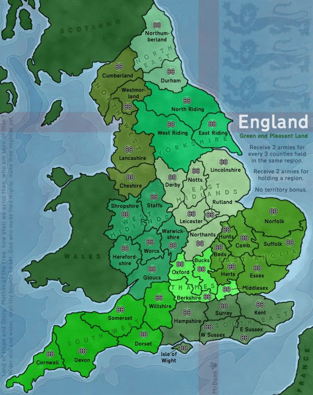
- To satisfy the pedants, Yorkshire has been divided into the three Ridings.
- I have redrawn the Sussex/Surrey/Kent border to clarify the connections there.
- The region names have been shifted slightly, and West Midlands has been rotated to give a better fit. The text colour has been toned down and adjusted so that it blends into each region a little more
PB: 2661 | He's blue... If he were green he would die | No mod would be stupid enough to do that
Re: England Map [D] - Update Mar 25th - p1/12
I'm in two minds about the bonus structure... Any thoughts?
PB: 2661 | He's blue... If he were green he would die | No mod would be stupid enough to do that
Re: England Map [D] - Update Mar 25th - p1/12
I don't know... I don't really have enough gameplay experience to judge that.
One thing though. I've been thinking about this for a while now. I've seen it on several maps, but never checked in early enough to be able to change it.
Before CC changed for the sake of copyright, all counties (on this map) were called 'territories'. Continents were called bonus regions or simply 'regions'. Then CC changed, and 'territories' was changed into... 'regions'.
It seems to me that very few mapmakers have noticed this change Because 'regions' is often still used for 'continents', as this map proves once more.
I don't know whether we could find a new word for 'bonus region' or 'continent', but personally it bothers me that two different subdivisions of a map get the same term.
And this time, I'm coming in early enough to make a change
What do you think?
One thing though. I've been thinking about this for a while now. I've seen it on several maps, but never checked in early enough to be able to change it.
Before CC changed for the sake of copyright, all counties (on this map) were called 'territories'. Continents were called bonus regions or simply 'regions'. Then CC changed, and 'territories' was changed into... 'regions'.
It seems to me that very few mapmakers have noticed this change
I don't know whether we could find a new word for 'bonus region' or 'continent', but personally it bothers me that two different subdivisions of a map get the same term.
And this time, I'm coming in early enough to make a change
What do you think?


Winner of "As Easy As 1, 2, 3! - Africa I", "Championship Series: British Isles",
"1v1 Battle to Rule Doodle Earth 2", "Connect 4 (Restarted)" and "Blind Fold Buddy - BeNeLux"