Conquer Club

Eastern Hemisphere [Quenched]

Care to peruse completed maps? Take a stroll through the Atlas.

Moderator: Cartographers

Forum rules
Please read the Community Guidelines before posting.

Re: Eastern Hemisphere; back on track, page 22 [I]

Postby iancanton on Mon Oct 06, 2008 6:34 pm

pamoa wrote:
iancanton wrote:is the number of neutrals on the ship a bit high at 5 rather than 3? I'd certainly avoid attacking 5 neutrals unless there was no other way, so the bonus regions in Africa and Oceania can almost be regarded as not having borders with the colonial powers during the opening and midgame.
oaktown wrote:That was kind of the idea - it should take a fairly strong European power to control the seas and disrupt empires abroad. Perhaps it is enough that it's a killer neutral?

The solution IS very acceptable. As I see it, the killer neutral means that if any European power does want it, it can disrupt any opponent commercial line for a while then it should be killer neutral 3 and could also happen at the beginning of the game, if someone get a good drop by example.

oaktown wrote:
asl80 wrote:so far i;m thinking that you've made a good compromise with the boat ... but am leaning towards an increase in its nuetral value ... remembering the intense power that can be wielded by a bombard position ... i.e. waterloo and arms race.

The difference here is that the boat is a killer neutral - you can't stack armies there to level people at will, and any armies that you do move in will either have to be used to attack or you lose them.

although the killer neutrals are showing strong support, i'm less convinced that someone will go through 5 neutrals (and therefore lose maybe 4 armies from attacking the ship plus at least 2 armies that are needed to carry out a feeble 1v1 suicide mission against a colony) to deprive an opponent of only 4 armies next turn: +4 is the highest value of bonus in a region that contains a colony. with 5 killer neutrals, i can see the ship becoming a useful weapon only when trying to break two or more bonuses in the same turn - but perhaps that's intentional.

any chance of persia regaining its border with british india, which it hasn't had since page 1?

ian. :)
User avatar
Brigadier iancanton
Foundry Foreman
Foundry Foreman
 
Posts: 2431
Joined: Fri Jun 01, 2007 5:40 am
Location: europe

empires

Postby $t0kA on Wed Oct 08, 2008 5:11 pm

not top ge too technical here or nothing but i'm pretty positive UK had a bit more than that in its empire in the early 1900's...australia and the suronding island for one...and some more of indo-china...and i know for sure that begium(netherlands)own congo and they taken
it in the late 1800's and mainatianed it until the 1930's....plz correct me if im wrong...
User avatar
Captain $t0kA
 
Posts: 28
Joined: Mon Feb 11, 2008 8:02 pm
Location: nova scotia

Re: empires

Postby asl80 on Fri Oct 10, 2008 3:18 am

$t0kA wrote:not top ge too technical here or nothing but i'm pretty positive UK had a bit more than that in its empire in the early 1900's...australia and the suronding island for one...and some more of indo-china...and i know for sure that begium(netherlands)own congo and they taken
it in the late 1800's and mainatianed it until the 1930's....plz correct me if im wrong...


sorry mate, australia officially federated as an independent dominion in 1901. (self governing etc.)
Lieutenant asl80
 
Posts: 208
Joined: Wed Jun 27, 2007 10:07 am

Re: Eastern Hemisphere; back on track, page 22 [I]

Postby RjBeals on Fri Oct 10, 2008 7:49 am

Great Looking Map Oak.
the only 2 comments I'll make, both of which I'm sure will not have any effect on this map, but I'll state anyway -

I'm really not a fan of the mountain ranges. They just don't fit the map style.
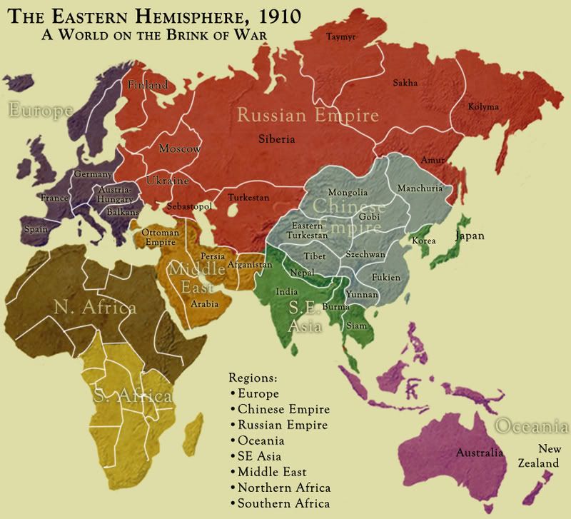
I'm really not a fan of the color fade on the borders. I don't like that in any maps really. Even the France map. I prefer solid colors like this old image. I also liked the bump map you used for relief:

Click image to enlarge.
image
Image
User avatar
Private RjBeals
 
Posts: 2506
Joined: Mon Nov 20, 2006 5:17 pm
Location: South Carolina, USA

Re: Eastern Hemisphere; back on track, page 22 [I]

Postby yeti_c on Fri Oct 10, 2008 8:17 am

Whilst I agree on Bumpmaps (Although it wouldn't fit the theme on this map) - I disagree against the mountains and the colours on the map - I really like the style he has here and the coloured "glows" are cool.

C.
Image
Highest score : 2297
User avatar
Lieutenant yeti_c
 
Posts: 9624
Joined: Thu Jan 04, 2007 9:02 am

Re: Eastern Hemisphere; back on track, page 22 [I]

Postby RjBeals on Fri Oct 10, 2008 8:33 am

yeti_c wrote:Whilst I agree on Bumpmaps (Although it wouldn't fit the theme on this map) - I disagree against the mountains and the colours on the map - I really like the style he has here and the coloured "glows" are cool.


Perhaps, Perhaps.

But the more I look at those mountains, the more I really don't like them, to put is nicely. They look like tree roots or something organic. My eyes are drawn to them and I can't look away.
Image
User avatar
Private RjBeals
 
Posts: 2506
Joined: Mon Nov 20, 2006 5:17 pm
Location: South Carolina, USA

Re: Eastern Hemisphere; back on track, page 22 [I]

Postby yeti_c on Fri Oct 10, 2008 9:44 am

That's what Mountains look like from the air...

C.
Image
Highest score : 2297
User avatar
Lieutenant yeti_c
 
Posts: 9624
Joined: Thu Jan 04, 2007 9:02 am

Re: Eastern Hemisphere; back on track, page 22 [I]

Postby RjBeals on Fri Oct 10, 2008 9:59 am

no they dont.
Image
User avatar
Private RjBeals
 
Posts: 2506
Joined: Mon Nov 20, 2006 5:17 pm
Location: South Carolina, USA

Re: Eastern Hemisphere; back on track, page 22 [I]

Postby ZeakCytho on Fri Oct 10, 2008 10:03 am

The colored glow is fine for me, but the mountains... :|
User avatar
Captain ZeakCytho
 
Posts: 1251
Joined: Wed Sep 12, 2007 4:36 pm

Re: Eastern Hemisphere; back on track, page 22 [I]

Postby yeti_c on Fri Oct 10, 2008 10:20 am

RjBeals wrote:no they dont.


Yes they do.

C>
Image
Highest score : 2297
User avatar
Lieutenant yeti_c
 
Posts: 9624
Joined: Thu Jan 04, 2007 9:02 am

Re: Eastern Hemisphere; back on track, page 22 [I]

Postby RjBeals on Fri Oct 10, 2008 10:30 am

yeti_c wrote:
RjBeals wrote:no they dont.


Yes they do.

C>


Not from that altitude.... No they do NOT

Image
Image
User avatar
Private RjBeals
 
Posts: 2506
Joined: Mon Nov 20, 2006 5:17 pm
Location: South Carolina, USA

Re: Eastern Hemisphere; back on track, page 22 [I]

Postby yeti_c on Fri Oct 10, 2008 10:31 am

RjBeals wrote:
yeti_c wrote:
RjBeals wrote:no they dont.


Yes they do.

C>


Not from that altitude.... No they do NOT

Image


That's not what I said - sure they're overscaled - but Mountains look like that...

If they were to scale - then you wouldn't be able to see them - thus ruining them as a gameplay element.

C.
Image
Highest score : 2297
User avatar
Lieutenant yeti_c
 
Posts: 9624
Joined: Thu Jan 04, 2007 9:02 am

Re: Eastern Hemisphere; back on track, page 22 [I]

Postby RjBeals on Fri Oct 10, 2008 10:40 am

I know I know yeti. the gameplay element is important. A few impassable's are a good thing. True geographic mountain ranges are an even better thing. The map is nice. I respect your point in that you like what artistic direction oak has taken with these mountain ranges. I'm sure lots of people also like them.

All I'm stating is that from the altitude of the entire map, the mountain ranges look bad to me. Personal taste. It's oak's map, he can do what he wishes. I'm simply stating my opinion, in this map thread, while it's still in development.

Done.
User avatar
Private RjBeals
 
Posts: 2506
Joined: Mon Nov 20, 2006 5:17 pm
Location: South Carolina, USA

Re: Eastern Hemisphere; back on track, page 22 [I]

Postby Sir. Ricco on Fri Oct 10, 2008 10:49 am

I like the direction this map is going. I love the graphics. The Naval Superiority is very clever. Keep up the good work.
Image
Image
Image
User avatar
Captain Sir. Ricco
 
Posts: 4555
Joined: Tue Oct 02, 2007 2:33 pm
Location: Making kingdoms burn and bloodshed start.

Re: Eastern Hemisphere; back on track, page 22 [I]

Postby asl80 on Fri Oct 10, 2008 9:58 pm

RjBeals wrote:
yeti_c wrote:Whilst I agree on Bumpmaps (Although it wouldn't fit the theme on this map) - I disagree against the mountains and the colours on the map - I really like the style he has here and the coloured "glows" are cool.


Perhaps, Perhaps.

But the more I look at those mountains, the more I really don't like them, to put is nicely. They look like tree roots or something organic. My eyes are drawn to them and I can't look away.


hehe rj ... i'm pretty sure mountains are organic too ... but, i could be wrong, Mr Megaloarchitect may have designed and constructed the world's mountain ranges in about 1788.

but your right, there may be some elements that could be improved on them ... i think their design is fine, but that in areas they look like they are too "stand alone" ... i.e. maybe they could be situated, as in some smaller scaled down mountains around the bigger ones ... i think what i'm saying is that the mountains are fine in them sleves ... but that the rest of the map, or the surrounding terrain around them is completely flat ... they need to be blended in a bit more.

P.S. love the great dividing range on australia, and especially the murray-darling riversystems !!! ahhh.
(here, the rest of australia is completely flat - mostly anyway - ... so they don't look out of place ... hehe)
Lieutenant asl80
 
Posts: 208
Joined: Wed Jun 27, 2007 10:07 am

Re: Eastern Hemisphere; back on track, page 22 [I]

Postby pamoa on Sat Oct 11, 2008 8:09 am

Like RjBeals, you had a nice bumped texture map, just put it as a semi transparent grey texture under your actual layers.
Click image to enlarge.
image
[/quote]
You can also try to add some bevel at your rivers so they seems to have a valley around.
Click image to enlarge.
image
De gueules Ć  la tour d'argent ouverte, crĆ©nelĆ©e de trois piĆØces, sommĆ©e d'un donjon ajourĆ©, crĆ©nelĆ© de deux piĆØces
Gules an open tower silver, crenellated three parts, topped by a apertured turret, crenellated two parts
User avatar
Cadet pamoa
 
Posts: 1242
Joined: Sat Sep 01, 2007 3:18 am
Location: Confederatio Helvetica

Re: Eastern Hemisphere; back on track, page 22 [I]

Postby oaktown on Sat Oct 11, 2008 12:23 pm

in general what I'm hearing is that the mountains are liked by some and not by others (which has been the case for months) but that there is a general consensus that more contour/texture would improve the overall effect. I can work with that. I've never been a fan of the beveled rivers. Most rivers don't have 200 foot embankments directly on each side, which is what the beveling looks like to me. Rather, major rivers run across wide plains and through gentle valleys.
User avatar
Captain oaktown
 
Posts: 4451
Joined: Sun Dec 03, 2006 9:24 pm
Location: majorcommand

Re: Eastern Hemisphere; back on track, page 22 [I]

Postby e_i_pi on Sun Oct 12, 2008 1:42 am

Um, not to harp on about a topic, but the mountains... ;)

I don't mind them, their style fits the overall style of the map pretty well. It surprises me, though, that you've put in the Great Dividing Range in Australia. I live about 10 minutes drive from the bottom of the escarpment of that very range, and let me tell you, it ain't so great. What constitues mountains in Australia, is hills to any native European. The tallest cliffs where I live (New South Wales) are only 20-30 metres high, and they're flat on top, not a series of cliffs. The Atlas mountains, Caucasus Mountains, Scandinavian Mountains, and Carpathian Mountains are all as high or higher than the tallest peak on the Great Divide (Mt Kosciusko) yet do not feature in the map. Hell, even Antarctica has higher mountains than Australia :P Is there any reason why you included the Great Divide? It doesn't actually alter gameplay, and I'm sure Australians would not be offended if it was left out - we know our country is the double A cup of the world :D
User avatar
Captain e_i_pi
 
Posts: 1775
Joined: Tue Feb 12, 2008 2:19 pm
Location: Corruption Capital of the world

Re: Eastern Hemisphere: pg. 13 [I]

Postby oaktown on Sun Oct 12, 2008 1:33 pm

e_i_pi wrote:Is there any reason why you included the Great Divide? It doesn't actually alter gameplay, and I'm sure Australians would not be offended if it was left out - we know our country is the double A cup of the world :D

Well, it was an Australian who suggested adding them...
cairnswk wrote:Oaktown, any chance of placing a "vein" of mountains down the east coast of Australia to represent the Great dividing Range? - it runs from Cape York and almost hugs the coast all the way through to western Victoria.
The river systems look good there and run on the western side of the mountains.

First you all couldn't (and still can't) decide if Australia was a British colony or not, now it's the mountains. I'm tempted to just drop the entire continent into the ocean, or stick it back on Antarctica like in the High Seas map.

But seriously, when I get around to scattering some more mountains here and there that don't impact gameplay - Africa, Asia, Eastern Europe - I think they will look less out of place.
User avatar
Captain oaktown
 
Posts: 4451
Joined: Sun Dec 03, 2006 9:24 pm
Location: majorcommand

Re: Eastern Hemisphere: pg. 13 [I]

Postby e_i_pi on Mon Oct 13, 2008 12:57 am

oaktown wrote:First you all couldn't (and still can't) decide if Australia was a British colony or not, now it's the mountains. I'm tempted to just drop the entire continent into the ocean, or stick it back on Antarctica like in the High Seas map.

??? :shock:

Australia was a British colony until federation in 1901. Before that we were part of Mother England. And let me tell you, she's been a bad mother... Gallipoli, Beersheba, Western Front, Boer War, and then they ditch us when Japan is on our doorstep. Idiots. Who would throw away the Australia bonus on the world map sheesh. :roll:

Keep in mind Australia is still part of the Commonwealth even today, and also still has a Governer General who can sack the PM at any time - the GG is the mouthpiece of the Queen. And don't any of you say it can't happen. Never forget Kerr's Cur!!! Besides, until about 1980, whenever the British said "jump", Australia would reply "Out of which trench and into which stream of machine-gun fire?"
User avatar
Captain e_i_pi
 
Posts: 1775
Joined: Tue Feb 12, 2008 2:19 pm
Location: Corruption Capital of the world

Re: Eastern Hemisphere: pg. 13 [I]

Postby asl80 on Mon Oct 13, 2008 1:15 am

e_i_pi wrote:
oaktown wrote:First you all couldn't (and still can't) decide if Australia was a British colony or not, now it's the mountains. I'm tempted to just drop the entire continent into the ocean, or stick it back on Antarctica like in the High Seas map.

??? :shock:

Australia was a British colony until federation in 1901. Before that we were part of Mother England. And let me tell you, she's been a bad mother... Gallipoli, Beersheba, Western Front, Boer War, and then they ditch us when Japan is on our doorstep. Idiots. Who would throw away the Australia bonus on the world map sheesh. :roll:

Keep in mind Australia is still part of the Commonwealth even today, and also still has a Governer General who can sack the PM at any time - the GG is the mouthpiece of the Queen. And don't any of you say it can't happen. Never forget Kerr's Cur!!! Besides, until about 1980, whenever the British said "jump", Australia would reply "Out of which trench and into which stream of machine-gun fire?"


hehe ... and now we are about to start defederating ... also we have just about succeeded in deforesting our, yes i admit comparatively small mountain ranges ... but, on the bright side, as the very symbolic gesture of our breaking up into minor and independent territories, continent wide, we are going to level the Great Dividing Range and share all its prehistoric volcanic materials with each independent territory in order that they may have soils appropriate enough for our current farming practices (which they currently lack) ... win win for all! ... now oaktown, if you'd be kind enough to incorporate these impending changes into your map, we all here in terra onceus australis may even consider remaining content.
... and yes governor pi ... this has all been orchestrated by her majesty's own sober market economists, this aint no rabel rousing eurakean movement!
Lieutenant asl80
 
Posts: 208
Joined: Wed Jun 27, 2007 10:07 am

Re: Eastern Hemisphere; back on track, page 22 [I]

Postby iancanton on Sat Oct 18, 2008 5:12 am

a question on the killer neutrals: if player 1 conquers the killer neutrals and keeps bombarding from the ship till he has only one man left, then does player 2 need to conquer only that one man before he can start bombarding, or does the ship reset to 5 neutrals as soon as player 2 starts his turn?

ian. :)
User avatar
Brigadier iancanton
Foundry Foreman
Foundry Foreman
 
Posts: 2431
Joined: Fri Jun 01, 2007 5:40 am
Location: europe

Re: Eastern Hemisphere; back on track, page 22 [I]

Postby TaCktiX on Sat Oct 18, 2008 1:19 pm

Killer neutrals only reset on the holding player's next turn. So for your example, player 2 would only have to kill player 1's single army.
User avatar
Corporal 1st Class TaCktiX
 
Posts: 2392
Joined: Mon Dec 17, 2007 8:24 pm
Location: Rapid City, SD

Re: Eastern Hemisphere; back on track, page 22 [I]

Postby oaktown on Sun Oct 19, 2008 8:36 pm

Click image to enlarge.
image

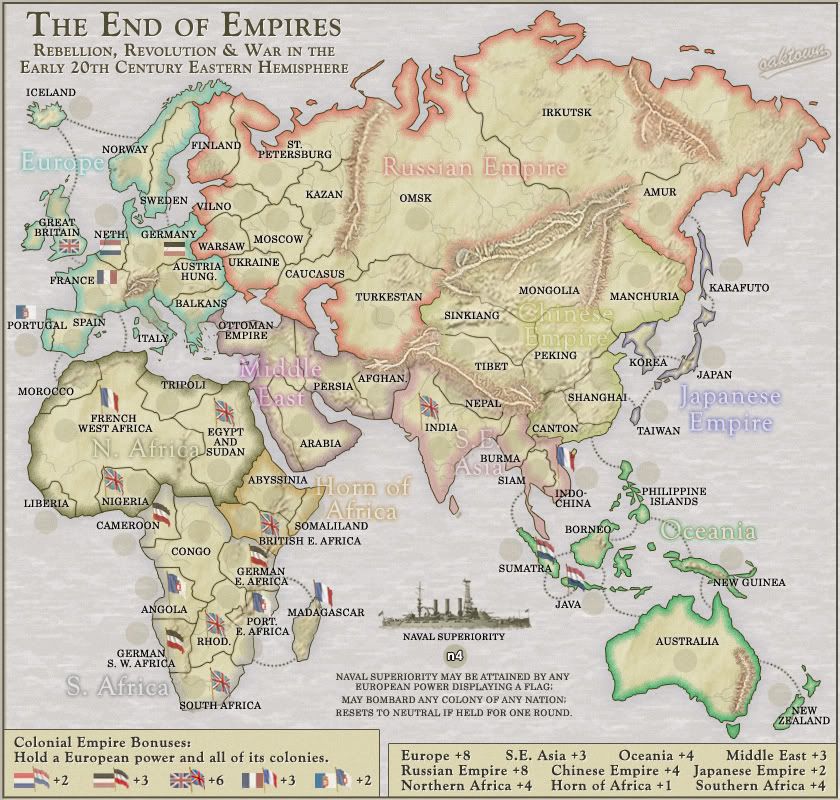
Apart from adding a general dusting of light mountains in appropriate places around the globe, I have reduced the starting/reset Neutral value of the Naval Superiority to 4. It was argued that 5 would prevent anybody from using it, while I felt that the standard 3 might make it too easy. I hope this is represents a happy medium.

I believe MrBenn has gameplay stamp duties on this one... let's see where he's wandered off to?

Since it's been a while, The basics of the current map are as follows:
ā€¢ 70 territories, 69 of which are starting.
ā€¢ Ten traditional bonus regions.
ā€¢ Empires are non-contiguous bonus regions.
ā€¢ Naval Superiority will start neutral with a value of 4 and revert back each round. Taking Naval Superiority allows European Powers to bombard colonies (flagged) territories around the globe; this is intended to reflect the military might of the European Empires of the time. The powers may NOT directly attack their colonies.
ā€¢ Eight territories in Europe - Great Britain, France, Spain, Portugal, Germany, Austria-Hungary, Italy, and Netherlands - will be coded as starting locations so nobody begins with an overwhelming European presence. All other territories will be normal starts. Should make for a historically appropriate, first world war style conflagration in Europe.
User avatar
Captain oaktown
 
Posts: 4451
Joined: Sun Dec 03, 2006 9:24 pm
Location: majorcommand

Re: Eastern Hemisphere; mountains (as usual) page 24 [I]

Postby oaktown on Mon Oct 20, 2008 12:36 am

And because I had nothing pressing to this this evening... the code.

Test results:

Warning: Territory Great Britain has border Naval Superiority, but not vice versa OK
Warning: Territory France has border Naval Superiority, but not vice versa OK
Warning: Territory Portugal has border Naval Superiority, but not vice versa OK
Warning: Territory Germany has border Naval Superiority, but not vice versa OK
Warning: Territory Netherlands has border Naval Superiority, but not vice versa OK
Warning: Territory Naval Superiority has no borders OK
Summary: 0 errors and 6 warnings detected in hemisphere.xml (14 continents, 70 territories)

Nuts... forgot to code the starting positions.

Code: Select all
<?xml version="1.0"?>
<map>
   <title>Hemisphere</title>
   <smallwidth>630</smallwidth>
   <smallheight>600</smallheight>
   <largewidth>840</largewidth>
   <largeheight>800</largeheight>
   <filetype>jpg</filetype>

   <continent>
      <name>Europe</name>
      <bonus>8</bonus>
      <components>
         <territory>Iceland</territory>
         <territory>Great Britain</territory>
         <territory>Norway</territory>
         <territory>Sweden</territory>
         <territory>Germany</territory>
         <territory>Netherlands</territory>
         <territory>Austria-Hungary</territory>
         <territory>Balkans</territory>
         <territory>Italy</territory>
         <territory>France</territory>
         <territory>Spain</territory>
         <territory>Portugal</territory>
      </components>
   </continent>

   <continent>
      <name>Northern Africa</name>
      <bonus>4</bonus>
      <components>
         <territory>Morocco</territory>
         <territory>French West Africa</territory>
         <territory>Tripoli</territory>
         <territory>Liberia</territory>
         <territory>Nigeria</territory>
         <territory>Egypt and Sudan</territory>
         </components>
   </continent>

   <continent>
      <name>Horn of Africa</name>
      <bonus>4</bonus>
      <components>
         <territory>Somaliland</territory>   
         <territory>Abyssinia</territory>
         <territory>British East Africa</territory>
         </components>
   </continent>

   <continent>
      <name>Southern Africa</name>
      <bonus>4</bonus>
      <components>
         <territory>Cameroon</territory>
         <territory>Congo</territory>
         <territory>German East Africa</territory>
         <territory>German South West Africa</territory>
         <territory>Rhodesia</territory>
         <territory>Angola</territory>
         <territory>Madagascar</territory>
         <territory>South Africa</territory>
         <territory>Portuguese East Africa</territory>
      </components>
   </continent>

   <continent>
      <name>Russian Empire</name>
      <bonus>8</bonus>
      <components>
         <territory>St. Petersburg</territory>
         <territory>Finland</territory>
         <territory>Vilno</territory>
         <territory>Warsaw</territory>
         <territory>Ukraine</territory>
         <territory>Moscow</territory>
         <territory>Kazan</territory>
         <territory>Caucasus</territory>
         <territory>Turkestan</territory>
         <territory>Omsk</territory>
         <territory>Irkutsk</territory>
         <territory>Amur</territory>
      </components>
   </continent>

   <continent>
      <name>Middle East</name>
      <bonus>3</bonus>
      <components>
         <territory>Ottoman Empire</territory>
         <territory>Arabia</territory>
         <territory>Persia</territory>
         <territory>Afghanistan</territory>
      </components>
   </continent>

   <continent>
      <name>Chinese Empire</name>
      <bonus>4</bonus>
      <components>
         <territory>Manchuria</territory>
         <territory>Mongolia</territory>
         <territory>Sinkiang</territory>
         <territory>Peking</territory>
         <territory>Tibet</territory>
         <territory>Shanghai</territory>
         <territory>Canton</territory>
      </components>
   </continent>

   <continent>
      <name>Oceania</name>
      <bonus>4</bonus>
      <components>
         <territory>Philippine Islands</territory>
         <territory>Borneo</territory>
         <territory>New Guinea</territory>
         <territory>Sumatra</territory>
         <territory>Java</territory>
         <territory>Australia</territory>
         <territory>New Zealand</territory>
      </components>
   </continent>
      
   <continent>
      <name>Japanese Empire</name>
      <bonus>2</bonus>
      <components>
         <territory>Japan</territory>
         <territory>Korea</territory>
         <territory>Karafuto</territory>
         <territory>Taiwan</territory>
      </components>
   </continent>
   
   <continent>
      <name>British Empire</name>
      <bonus>6</bonus>
      <components>
         <territory>Great Britain</territory>
         <territory>Rhodesia</territory>
         <territory>South Africa</territory>
         <territory>Nigeria</territory>
         <territory>India</territory>
         <territory>Egypt and Sudan</territory>
         <territory>British East Africa</territory>
      </components>
   </continent>   
   
   <continent>
      <name>Portuguese Empire</name>
      <bonus>2</bonus>
      <components>
         <territory>Portugal</territory>
         <territory>Angola</territory>
         <territory>Portuguese East Africa</territory>
      </components>
   </continent>
   
   <continent>
      <name>French Empire</name>
      <bonus>3</bonus>
      <components>
         <territory>France</territory>
         <territory>Madagascar</territory>
         <territory>Indochina</territory>
         <territory>French West Africa</territory>
      </components>
   </continent>   
   
   <continent>
      <name>German Empire</name>
      <bonus>3</bonus>
      <components>
         <territory>Germany</territory>
         <territory>Cameroon</territory>
         <territory>German South West Africa</territory>
         <territory>German East Africa</territory>
      </components>
   </continent>      
   
   <continent>
      <name>Dutch Empire</name>
      <bonus>2</bonus>
      <components>
         <territory>Netherlands</territory>
         <territory>Sumatra</territory>
         <territory>Java</territory>
      </components>
   </continent>      
   
   
   <territory>
      <name>Iceland</name>
      <borders>
         <border>Norway</border>
         <border>Great Britain</border>
      </borders>
            <coordinates>
         <smallx>557</smallx>
         <smally>368</smally>
         <largex>697</largex>
         <largey>455</largey>
      </coordinates>
   </territory>
   <territory>
      <name>Great Britain</name>
      <borders>
         <border>Iceland</border>
         <border>France</border>
         <border>Naval Superiority</border>
      </borders>
            <coordinates>
         <smallx>557</smallx>
         <smally>368</smally>
         <largex>697</largex>
         <largey>455</largey>
      </coordinates>
   </territory>
   <territory>
      <name>Norway</name>
      <borders>
         <border>Iceland</border>
         <border>Sweden</border>
         <border>Finland</border>
      </borders>
            <coordinates>
         <smallx>557</smallx>
         <smally>368</smally>
         <largex>697</largex>
         <largey>455</largey>
      </coordinates>
   </territory>
   <territory>
      <name>Sweden</name>
      <borders>
         <border>Norway</border>
         <border>Germany</border>
         <border>Finland</border>
      </borders>
            <coordinates>
         <smallx>557</smallx>
         <smally>368</smally>
         <largex>697</largex>
         <largey>455</largey>
      </coordinates>
   </territory>
   <territory>
      <name>France</name>
      <borders>
         <border>Great Britain</border>
         <border>Spain</border>
         <border>Netherlands</border>
         <border>Italy</border>
         <border>Germany</border>
         <border>French West Africa</border>
         <border>Naval Superiority</border>
      </borders>
            <coordinates>
         <smallx>557</smallx>
         <smally>368</smally>
         <largex>697</largex>
         <largey>455</largey>
      </coordinates>
   </territory>
   <territory>
      <name>Spain</name>
      <borders>
         <border>Portugal</border>
         <border>Morocco</border>
         <border>France</border>
      </borders>
            <coordinates>
         <smallx>557</smallx>
         <smally>368</smally>
         <largex>697</largex>
         <largey>455</largey>
      </coordinates>
   </territory>
   <territory>
      <name>Portugal</name>
      <borders>
         <border>Spain</border>
         <border>Naval Superiority</border>
      </borders>
            <coordinates>
         <smallx>557</smallx>
         <smally>368</smally>
         <largex>697</largex>
         <largey>455</largey>
      </coordinates>
   </territory>
   <territory>
      <name>Germany</name>
      <borders>
         <border>France</border>
         <border>Netherlands</border>
         <border>Sweden</border>
         <border>Warsaw</border>
         <border>Austria-Hungary</border>
         <border>Vilno</border>
         <border>Naval Superiority</border>
      </borders>
            <coordinates>
         <smallx>557</smallx>
         <smally>368</smally>
         <largex>697</largex>
         <largey>455</largey>
      </coordinates>
   </territory>
   <territory>
      <name>Austria-Hungary</name>
      <borders>
         <border>Germany</border>
         <border>Warsaw</border>
         <border>Ukraine</border>
         <border>Balkans</border>
         <border>Italy</border>
      </borders>
            <coordinates>
         <smallx>557</smallx>
         <smally>368</smally>
         <largex>697</largex>
         <largey>455</largey>
      </coordinates>
   </territory>
   <territory>
      <name>Italy</name>
      <borders>
         <border>France</border>
         <border>Austria-Hungary</border>
      </borders>
            <coordinates>
         <smallx>557</smallx>
         <smally>368</smally>
         <largex>697</largex>
         <largey>455</largey>
      </coordinates>
   </territory>
   <territory>
      <name>Netherlands</name>
      <borders>
         <border>France</border>
         <border>Germany</border>
         <border>Naval Superiority</border>
      </borders>
            <coordinates>
         <smallx>557</smallx>
         <smally>368</smally>
         <largex>697</largex>
         <largey>455</largey>
      </coordinates>
   </territory>
   <territory>
      <name>Balkans</name>
      <borders>
         <border>Austria-Hungary</border>
         <border>Ukraine</border>
         <border>Ottoman Empire</border>
      </borders>
            <coordinates>
         <smallx>557</smallx>
         <smally>368</smally>
         <largex>697</largex>
         <largey>455</largey>
      </coordinates>
   </territory>
   
   
   <territory>
      <name>Morocco</name>
      <borders>
         <border>Spain</border>
         <border>French West Africa</border>
      </borders>
            <coordinates>
         <smallx>557</smallx>
         <smally>368</smally>
         <largex>697</largex>
         <largey>455</largey>
      </coordinates>
   </territory>
   <territory>
      <name>Liberia</name>
      <borders>
         <border>French West Africa</border>
      </borders>
            <coordinates>
         <smallx>557</smallx>
         <smally>368</smally>
         <largex>697</largex>
         <largey>455</largey>
      </coordinates>
   </territory>
   <territory>
      <name>French West Africa</name>
      <borders>
         <border>France</border>
         <border>Tripoli</border>
         <border>Morocco</border>
         <border>Liberia</border>
         <border>Nigeria</border>
         <border>Cameroon</border>
         <border>Congo</border>
         <border>Egypt and Sudan</border>
      </borders>      
            <coordinates>
         <smallx>557</smallx>
         <smally>368</smally>
         <largex>697</largex>
         <largey>455</largey>
      </coordinates>
   </territory>
   <territory>
      <name>Tripoli</name>
      <borders>
         <border>French West Africa</border>
         <border>Egypt and Sudan</border>
      </borders>
            <coordinates>
         <smallx>557</smallx>
         <smally>368</smally>
         <largex>697</largex>
         <largey>455</largey>
      </coordinates>
   </territory>
   <territory>
      <name>Nigeria</name>
      <borders>
         <border>French West Africa</border>
         <border>Cameroon</border>
      </borders>   
            <coordinates>
         <smallx>557</smallx>
         <smally>368</smally>
         <largex>697</largex>
         <largey>455</largey>
      </coordinates>
   </territory>
   <territory>
      <name>Egypt and Sudan</name>
      <borders>
         <border>Tripoli</border>
         <border>French West Africa</border>
         <border>Abyssinia</border>
         <border>Ottoman Empire</border>
         <border>Congo</border>
         <border>British East Africa</border>
      </borders>   
            <coordinates>
         <smallx>557</smallx>
         <smally>368</smally>
         <largex>697</largex>
         <largey>455</largey>
      </coordinates>
   </territory>
   
   
   <territory>
      <name>Abyssinia</name>
      <borders>
         <border>Egypt and Sudan</border>
         <border>Somaliland</border>
         <border>British East Africa</border>
      </borders>
            <coordinates>
         <smallx>557</smallx>
         <smally>368</smally>
         <largex>697</largex>
         <largey>455</largey>
      </coordinates>
   </territory>
   <territory>
      <name>Somaliland</name>
      <borders>
         <border>Abyssinia</border>
         <border>British East Africa</border>
      </borders>
            <coordinates>
         <smallx>557</smallx>
         <smally>368</smally>
         <largex>697</largex>
         <largey>455</largey>
      </coordinates>
   </territory>
   <territory>
      <name>British East Africa</name>
      <borders>
         <border>Abyssinia</border>
         <border>Somaliland</border>
         <border>Congo</border>
         <border>German East Africa</border>
         <border>Egypt and Sudan</border>
      </borders>
            <coordinates>
         <smallx>557</smallx>
         <smally>368</smally>
         <largex>697</largex>
         <largey>455</largey>
      </coordinates>
   </territory>   
   
   <territory>
      <name>Cameroon</name>
      <borders>
         <border>Congo</border>
         <border>Nigeria</border>
         <border>French West Africa</border>
      </borders>      
            <coordinates>
         <smallx>557</smallx>
         <smally>368</smally>
         <largex>697</largex>
         <largey>455</largey>
      </coordinates>
   </territory>
   <territory>
      <name>Congo</name>
      <borders>
         <border>Angola</border>
         <border>Cameroon</border>
         <border>French West Africa</border>
         <border>German East Africa</border>
         <border>Rhodesia</border>
         <border>Egypt and Sudan</border>
         <border>British East Africa</border>
      </borders>
            <coordinates>
         <smallx>557</smallx>
         <smally>368</smally>
         <largex>697</largex>
         <largey>455</largey>
      </coordinates>
   </territory>
   <territory>
      <name>Angola</name>
      <borders>
         <border>Congo</border>
         <border>Rhodesia</border>
         <border>German South West Africa</border>
      </borders>
            <coordinates>
         <smallx>557</smallx>
         <smally>368</smally>
         <largex>697</largex>
         <largey>455</largey>
      </coordinates>
   </territory>
   <territory>
      <name>German South West Africa</name>
      <borders>
         <border>South Africa</border>
         <border>Rhodesia</border>
         <border>Angola</border>
      </borders>      
            <coordinates>
         <smallx>557</smallx>
         <smally>368</smally>
         <largex>697</largex>
         <largey>455</largey>
      </coordinates>
   </territory>
   <territory>
      <name>South Africa</name>
      <borders>
         <border>German South West Africa</border>
         <border>Rhodesia</border>
         <border>Portuguese East Africa</border>
      </borders>      
            <coordinates>
         <smallx>557</smallx>
         <smally>368</smally>
         <largex>697</largex>
         <largey>455</largey>
      </coordinates>
   </territory>
   <territory>
      <name>Rhodesia</name>
      <borders>
         <border>Congo</border>
         <border>Angola</border>
         <border>German South West Africa</border>
         <border>South Africa</border>
         <border>Portuguese East Africa</border>
         <border>German East Africa</border>
      </borders>      
            <coordinates>
         <smallx>557</smallx>
         <smally>368</smally>
         <largex>697</largex>
         <largey>455</largey>
      </coordinates>
   </territory>
   <territory>
      <name>Portuguese East Africa</name>
      <borders>
         <border>Madagascar</border>
         <border>Rhodesia</border>
         <border>South Africa</border>
         <border>German East Africa</border>
      </borders>
            <coordinates>
         <smallx>557</smallx>
         <smally>368</smally>
         <largex>697</largex>
         <largey>455</largey>
      </coordinates>
   </territory>
   <territory>
      <name>Madagascar</name>
      <borders>
         <border>Portuguese East Africa</border>
         <border>German East Africa</border>
      </borders>
            <coordinates>
         <smallx>557</smallx>
         <smally>368</smally>
         <largex>697</largex>
         <largey>455</largey>
      </coordinates>
   </territory>
   <territory>
      <name>German East Africa</name>
      <borders>
         <border>Madagascar</border>
         <border>Congo</border>
         <border>Rhodesia</border>
         <border>Portuguese East Africa</border>
         <border>British East Africa</border>
      </borders>
            <coordinates>
         <smallx>557</smallx>
         <smally>368</smally>
         <largex>697</largex>
         <largey>455</largey>
      </coordinates>
   </territory>
   
   
   <territory>
      <name>Ottoman Empire</name>
      <borders>
         <border>Balkans</border>
         <border>Caucasus</border>
         <border>Persia</border>
         <border>Arabia</border>
         <border>Egypt and Sudan</border>
      </borders>
            <coordinates>
         <smallx>557</smallx>
         <smally>368</smally>
         <largex>697</largex>
         <largey>455</largey>
      </coordinates>
   </territory>
   <territory>
      <name>Arabia</name>
      <borders>
         <border>Ottoman Empire</border>
         <border>Persia</border>
      </borders>
            <coordinates>
         <smallx>557</smallx>
         <smally>368</smally>
         <largex>697</largex>
         <largey>455</largey>
      </coordinates>
   </territory>
   <territory>
      <name>Persia</name>
      <borders>
         <border>Ottoman Empire</border>
         <border>Caucasus</border>
         <border>Arabia</border>
         <border>Turkestan</border>
         <border>Afghanistan</border>
      </borders>
            <coordinates>
         <smallx>557</smallx>
         <smally>368</smally>
         <largex>697</largex>
         <largey>455</largey>
      </coordinates>
   </territory>
   <territory>
      <name>Afghanistan</name>
      <borders>
         <border>India</border>
         <border>Persia</border>
      </borders>
            <coordinates>
         <smallx>557</smallx>
         <smally>368</smally>
         <largex>697</largex>
         <largey>455</largey>
      </coordinates>
   </territory>
   
   
   <territory>
      <name>Finland</name>
      <borders>
         <border>Norway</border>
         <border>Sweden</border>
         <border>St. Petersburg</border>
      </borders>
            <coordinates>
         <smallx>557</smallx>
         <smally>368</smally>
         <largex>697</largex>
         <largey>455</largey>
      </coordinates>
   </territory>
   <territory>
      <name>St. Petersburg</name>
      <borders>
         <border>Kazan</border>
         <border>Vilno</border>
         <border>Moscow</border>
         <border>Finland</border>
      </borders>
            <coordinates>
         <smallx>557</smallx>
         <smally>368</smally>
         <largex>697</largex>
         <largey>455</largey>
      </coordinates>
   </territory>
   <territory>
      <name>Warsaw</name>
      <borders>
         <border>Vilno</border>
         <border>Moscow</border>
         <border>Ukraine</border>
         <border>Germany</border>
         <border>Austria-Hungary</border>
      </borders>
            <coordinates>
         <smallx>557</smallx>
         <smally>368</smally>
         <largex>697</largex>
         <largey>455</largey>
      </coordinates>
   </territory>
   <territory>
      <name>Vilno</name>
      <borders>
         <border>St. Petersburg</border>
         <border>Warsaw</border>
         <border>Moscow</border>
         <border>Germany</border>
      </borders>
            <coordinates>
         <smallx>557</smallx>
         <smally>368</smally>
         <largex>697</largex>
         <largey>455</largey>
      </coordinates>
   </territory>
   <territory>
      <name>Ukraine</name>
      <borders>
         <border>Warsaw</border>
         <border>Moscow</border>   
         <border>Caucasus</border>
         <border>Austria-Hungary</border>
         <border>Balkans</border>         
      </borders>
            <coordinates>
         <smallx>557</smallx>
         <smally>368</smally>
         <largex>697</largex>
         <largey>455</largey>
      </coordinates>
   </territory>
   <territory>
      <name>Moscow</name>
      <borders>
         <border>Vilno</border>
         <border>Ukraine</border>
         <border>Kazan</border>
         <border>St. Petersburg</border>
         <border>Warsaw</border>
         <border>Caucasus</border>
      </borders>
            <coordinates>
         <smallx>557</smallx>
         <smally>368</smally>
         <largex>697</largex>
         <largey>455</largey>
      </coordinates>
   </territory>
   <territory>
      <name>Kazan</name>
      <borders>
         <border>St. Petersburg</border>
         <border>Moscow</border>
         <border>Caucasus</border>
      </borders>
            <coordinates>
         <smallx>557</smallx>
         <smally>368</smally>
         <largex>697</largex>
         <largey>455</largey>
      </coordinates>
   </territory>
   <territory>
      <name>Caucasus</name>
      <borders>
         <border>Kazan</border>
         <border>Turkestan</border>
         <border>Moscow</border>
         <border>Omsk</border>
         <border>Ukraine</border>
         <border>Ottoman Empire</border>
         <border>Persia</border>
      </borders>
            <coordinates>
         <smallx>557</smallx>
         <smally>368</smally>
         <largex>697</largex>
         <largey>455</largey>
      </coordinates>
   </territory>
   <territory>
      <name>Turkestan</name>
      <borders>
         <border>Caucasus</border>
         <border>Sinkiang</border>
         <border>Omsk</border>
         <border>Persia</border>
      </borders>
            <coordinates>
         <smallx>557</smallx>
         <smally>368</smally>
         <largex>697</largex>
         <largey>455</largey>   
      </coordinates>
   </territory>
   <territory>
      <name>Omsk</name>
      <borders>
         <border>Irkutsk</border>
         <border>Turkestan</border>
         <border>Caucasus</border>
      </borders>
            <coordinates>
         <smallx>557</smallx>
         <smally>368</smally>
         <largex>697</largex>
         <largey>455</largey>   
      </coordinates>
   </territory>
   <territory>
      <name>Amur</name>
      <borders>
         <border>Karafuto</border>
         <border>Irkutsk</border>
         <border>Manchuria</border>
      </borders>
            <coordinates>
         <smallx>557</smallx>
         <smally>368</smally>
         <largex>697</largex>
         <largey>455</largey>   
      </coordinates>
   </territory>
   <territory>
      <name>Irkutsk</name>
      <borders>
         <border>Omsk</border>
         <border>Amur</border>
      </borders>
            <coordinates>
         <smallx>557</smallx>
         <smally>368</smally>
         <largex>697</largex>
         <largey>455</largey>   
      </coordinates>
   </territory>
   
   
   <territory>
      <name>Sinkiang</name>
      <borders>
         <border>Tibet</border>
         <border>Peking</border>
         <border>Mongolia</border>
         <border>Turkestan</border>
      </borders>
            <coordinates>
         <smallx>557</smallx>
         <smally>368</smally>
         <largex>697</largex>
         <largey>455</largey>   
      </coordinates>
   </territory>
   <territory>
      <name>Tibet</name>
      <borders>
         <border>Sinkiang</border>
         <border>Peking</border>
      </borders>
            <coordinates>
         <smallx>557</smallx>
         <smally>368</smally>
         <largex>697</largex>
         <largey>455</largey>   
      </coordinates>
   </territory>
   <territory>
      <name>Mongolia</name>
      <borders>
         <border>Sinkiang</border>
         <border>Peking</border>
      </borders>
            <coordinates>
         <smallx>557</smallx>
         <smally>368</smally>
         <largex>697</largex>
         <largey>455</largey>   
      </coordinates>
   </territory>
   <territory>
      <name>Peking</name>
      <borders>
         <border>Sinkiang</border>
         <border>Tibet</border>
         <border>Canton</border>
         <border>Shanghai</border>
         <border>Manchuria</border>
         <border>Mongolia</border>
      </borders>
            <coordinates>
         <smallx>557</smallx>
         <smally>368</smally>
         <largex>697</largex>
         <largey>455</largey>   
      </coordinates>
   </territory>
   <territory>
      <name>Canton</name>
      <borders>
         <border>Peking</border>
         <border>Shanghai</border>
         <border>Indochina</border>
         <border>Burma</border>
         <border>Philippine Islands</border>
      </borders>
            <coordinates>
         <smallx>557</smallx>
         <smally>368</smally>
         <largex>697</largex>
         <largey>455</largey>   
      </coordinates>
   </territory>
   <territory>
      <name>Shanghai</name>
      <borders>
         <border>Peking</border>
         <border>Canton</border>
         <border>Taiwan</border>
      </borders>
            <coordinates>
         <smallx>557</smallx>
         <smally>368</smally>
         <largex>697</largex>
         <largey>455</largey>   
      </coordinates>
   </territory>
   <territory>
      <name>Manchuria</name>
      <borders>
         <border>Amur</border>
         <border>Korea</border>
         <border>Peking</border>
      </borders>
            <coordinates>
         <smallx>557</smallx>
         <smally>368</smally>
         <largex>697</largex>
         <largey>455</largey>   
      </coordinates>
   </territory>   


   <territory>
      <name>India</name>
      <borders>
         <border>Afghanistan</border>
         <border>Nepal</border>
         <border>Burma</border>
      </borders>
            <coordinates>
         <smallx>557</smallx>
         <smally>368</smally>
         <largex>697</largex>
         <largey>455</largey>
      </coordinates>
   </territory>
   <territory>
      <name>Nepal</name>
      <borders>
         <border>India</border>
      </borders>
            <coordinates>
         <smallx>557</smallx>
         <smally>368</smally>
         <largex>697</largex>
         <largey>455</largey>   
      </coordinates>
   </territory>
   <territory>
      <name>Burma</name>
      <borders>
         <border>India</border>
         <border>Siam</border>
         <border>Indochina</border>
         <border>Canton</border>
      </borders>
            <coordinates>
         <smallx>557</smallx>
         <smally>368</smally>
         <largex>697</largex>
         <largey>455</largey>   
      </coordinates>
   </territory>
   <territory>
      <name>Siam</name>
      <borders>
         <border>Burma</border>
         <border>Indochina</border>
         <border>Sumatra</border>
      </borders>
            <coordinates>
         <smallx>557</smallx>
         <smally>368</smally>
         <largex>697</largex>
         <largey>455</largey>   
      </coordinates>
   </territory>
   <territory>
      <name>Indochina</name>
      <borders>
         <border>Canton</border>
         <border>Burma</border>
         <border>Siam</border>
      </borders>
            <coordinates>
         <smallx>557</smallx>
         <smally>368</smally>
         <largex>697</largex>
         <largey>455</largey>   
      </coordinates>
   </territory>   
   
   <territory>
      <name>Japan</name>
      <borders>
         <border>Karafuto</border>
         <border>Korea</border>
         <border>Taiwan</border>
      </borders>
            <coordinates>
         <smallx>557</smallx>
         <smally>368</smally>
         <largex>697</largex>
         <largey>455</largey>   
      </coordinates>
   </territory>
   <territory>
      <name>Karafuto</name>
      <borders>
         <border>Amur</border>
         <border>Japan</border>
      </borders>
            <coordinates>
         <smallx>557</smallx>
         <smally>368</smally>
         <largex>697</largex>
         <largey>455</largey>   
      </coordinates>
   </territory>
   <territory>
      <name>Korea</name>
      <borders>
         <border>Manchuria</border>
         <border>Japan</border>
      </borders>
            <coordinates>
         <smallx>557</smallx>
         <smally>368</smally>
         <largex>697</largex>
         <largey>455</largey>   
      </coordinates>
   </territory>
   <territory>
      <name>Taiwan</name>
      <borders>
         <border>Japan</border>
         <border>Shanghai</border>
      </borders>
            <coordinates>
         <smallx>557</smallx>
         <smally>368</smally>
         <largex>697</largex>
         <largey>455</largey>   
      </coordinates>
   </territory>


   <territory>
      <name>Philippine Islands</name>
      <borders>
         <border>Canton</border>
         <border>Borneo</border>
         <border>New Guinea</border>
      </borders>
            <coordinates>
         <smallx>557</smallx>
         <smally>368</smally>
         <largex>697</largex>
         <largey>455</largey>   
      </coordinates>
   </territory>
   <territory>
      <name>Borneo</name>
      <borders>
         <border>Philippine Islands</border>
         <border>Sumatra</border>
         <border>Java</border>
      </borders>
            <coordinates>
         <smallx>557</smallx>
         <smally>368</smally>
         <largex>697</largex>
         <largey>455</largey>   
      </coordinates>
   </territory>
   <territory>
      <name>Sumatra</name>
      <borders>
         <border>Borneo</border>
         <border>Siam</border>
         <border>Java</border>
      </borders>
            <coordinates>
         <smallx>557</smallx>
         <smally>368</smally>
         <largex>697</largex>
         <largey>455</largey>   
      </coordinates>
   </territory>
   <territory>
      <name>Java</name>
      <borders>
         <border>Borneo</border>
         <border>Sumatra</border>
         <border>Australia</border>
      </borders>
            <coordinates>
         <smallx>557</smallx>
         <smally>368</smally>
         <largex>697</largex>
         <largey>455</largey>   
      </coordinates>
   </territory>
   <territory>
      <name>New Guinea</name>
      <borders>
         <border>Philippine Islands</border>
         <border>Australia</border>
      </borders>
            <coordinates>
         <smallx>557</smallx>
         <smally>368</smally>
         <largex>697</largex>
         <largey>455</largey>   
      </coordinates>
   </territory>
   <territory>
      <name>Australia</name>
      <borders>
         <border>Java</border>
         <border>New Guinea</border>
         <border>New Zealand</border>
      </borders>
            <coordinates>
         <smallx>557</smallx>
         <smally>368</smally>
         <largex>697</largex>
         <largey>455</largey>   
      </coordinates>
   </territory>
   <territory>
      <name>New Zealand</name>
      <borders>
         <border>Australia</border>
      </borders>
            <coordinates>
         <smallx>557</smallx>
         <smally>368</smally>
         <largex>697</largex>
         <largey>455</largey>   
      </coordinates>
   </territory>


   <territory>
      <name>Naval Superiority</name>
      <borders>
      </borders>
       <bombardments>
       <bombardment>Indochina</bombardment>
         <bombardment>Madagascar</bombardment>
         <bombardment>French West Africa</bombardment>
         <bombardment>Rhodesia</bombardment>
         <bombardment>India</bombardment>
         <bombardment>South Africa</bombardment>
         <bombardment>Egypt and Sudan</bombardment>
         <bombardment>British East Africa</bombardment>
         <bombardment>Sumatra</bombardment>
         <bombardment>Java</bombardment>
         <bombardment>Nigeria</bombardment>
         <bombardment>Cameroon</bombardment>
         <bombardment>German South West Africa</bombardment>
         <bombardment>German East Africa</bombardment>
         <bombardment>Angola</bombardment>
         <bombardment>Portuguese East Africa</bombardment>
      </bombardments>
            <coordinates>
         <smallx>557</smallx>
         <smally>368</smally>
         <largex>697</largex>
         <largey>455</largey>   
      </coordinates>
   </territory>

</map>
User avatar
Captain oaktown
 
Posts: 4451
Joined: Sun Dec 03, 2006 9:24 pm
Location: majorcommand

PreviousNext

Return to The Atlas

Who is online

Users browsing this forum: No registered users

cron