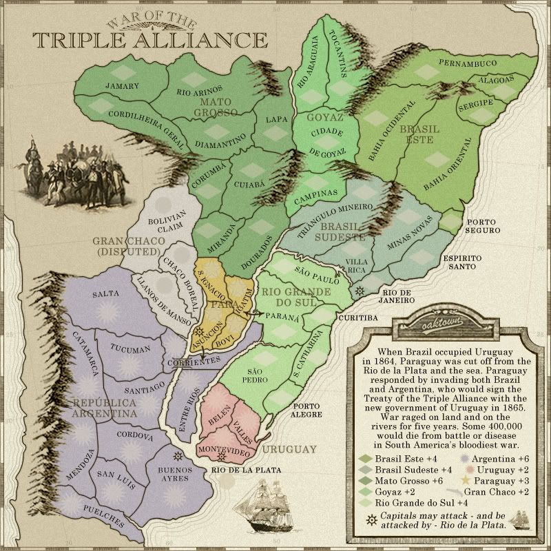
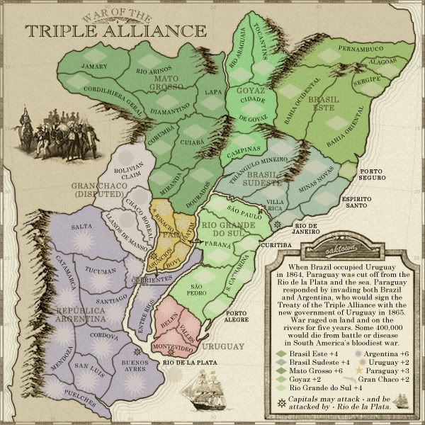
EDIT: Oaktown can I get a preview of the small please?
War of the Triple Alliance
Moderator: Cartographers
Re: War of the Triple Alliance; new update pg. 10 [D, Gp]
With those numbers on top the diamonds don't look so bad 
EDIT: Oaktown can I get a preview of the small please?
EDIT: Oaktown can I get a preview of the small please?
What do you know about map making, bitch?
Top Score:2403
natty_dread wrote:I was wrong
Top Score:2403
-

 gimil
gimil
- Posts: 8599
- Joined: Sat Mar 03, 2007 12:42 pm
- Location: United Kingdom (Scotland)


Re: War of the Triple Alliance; new update pg. 10 [D, Gp]
Small version, with stroke added to all army circles/diamonds to beef them up... I probably forgot to do something on it... it's late... sleepy...
-

 oaktown
- Posts: 4451
- Joined: Sun Dec 03, 2006 9:24 pm
- Location: majorcommand


Re: War of the Triple Alliance; new update pg. 10 [D, Gp]
Could you not align the right hand column in the legend as well? - I think it looks a bit messy unaligned?
C.
C.

Highest score : 2297
-

 yeti_c
- Posts: 9624
- Joined: Thu Jan 04, 2007 9:02 am


Re: War of the Triple Alliance; new update pg. 10 [D, Gp]
yeti_c wrote:Could you not align the right hand column in the legend as well? - I think it looks a bit messy unaligned?
C.
It's aligned down the right side (err, mostly; I'll fix the 6). Making it left justified will require either more space or a smaller typeface, and I think it's almost too small already in the small map.
-

 oaktown
- Posts: 4451
- Joined: Sun Dec 03, 2006 9:24 pm
- Location: majorcommand


Re: War of the Triple Alliance; new update pg. 10 [D, Gp]
okay Mr. Grammar - shouldn't there be a period after the last word in your sentence, "war"? You have punctuation throughout the rest of the paragraph? Great looking map though Oaktown. True to your style, with great looking mountains.

-

 RjBeals
- Posts: 2506
- Joined: Mon Nov 20, 2006 5:17 pm
- Location: South Carolina, USA


Re: War of the Triple Alliance; new update pg. 10 [D, Gp]

Here you go big guy! Seems its just minor trivia going on in here now.
What do you know about map making, bitch?
Top Score:2403
natty_dread wrote:I was wrong
Top Score:2403
-

 gimil
gimil
- Posts: 8599
- Joined: Sat Mar 03, 2007 12:42 pm
- Location: United Kingdom (Scotland)


Re: War of the Triple Alliance; new update pg. 10 [D, Gp]
oaktown wrote:Hmm, I seem to have lost the period (.) at the end of the text... noted.
Mr. Grammar caught the error three days before you, Rj!
-

 oaktown
- Posts: 4451
- Joined: Sun Dec 03, 2006 9:24 pm
- Location: majorcommand


Re: War of the Triple Alliance; new update pg. 10 [D, Gp]
i've just realised that brasil este is a 3-border, 6-territory bonus region, just like classic africa, but with the added advantage of being in a corner and therefore not on an attack route between two bonus regions. should the bonus be +3 rather than +4?
ian.
ian.
-

 iancanton
- Foundry Foreman

- Posts: 2432
- Joined: Fri Jun 01, 2007 5:40 am
- Location: europe


Re: War of the Triple Alliance; new update pg. 10 [D, Gp]
iancanton wrote:i've just realised that brasil este is a 3-border, 6-territory bonus region, just like classic africa, but with the added advantage of being in a corner and therefore not on an attack route between two bonus regions. should the bonus be +3 rather than +4?
I've always thought that Africa was a borderline +3/+4 in classic... how many times have you won with an africa start? Probably not often, because you end up clashing with the guy who wrapped up South America two rounds before you, and you beat up on each other until the guy in North America takes you both out.
I think that whether or not a 6 teritory, 3 border region is a +3 or a +4 depends on the rest of the map. This particular map is bigger than classic (52 v. 42), and contains two other similarly-sized +4 regions, as well as a four territory +3. Overall the bonuses are a bit higher here than what you see on classic, which I think is fine so long as they are in line with each other and no one region gives an unfair advantage.
A good example of a map that has consistently generous bonuses is Portugal - even though it is a bit smaller than classic, the higher bonus work because they are balanced across the map. Portugal also has a six terit, three border +4 region, but it doesn't provide an advantage over the other bonuses which are similarly high. I hope that the bonuses here - while a touch high - are in balance with each other.
-

 oaktown
- Posts: 4451
- Joined: Sun Dec 03, 2006 9:24 pm
- Location: majorcommand


Re: War of the Triple Alliance; new update pg. 11 [D, Gp, Gr]
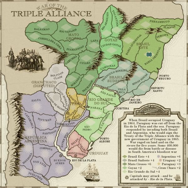
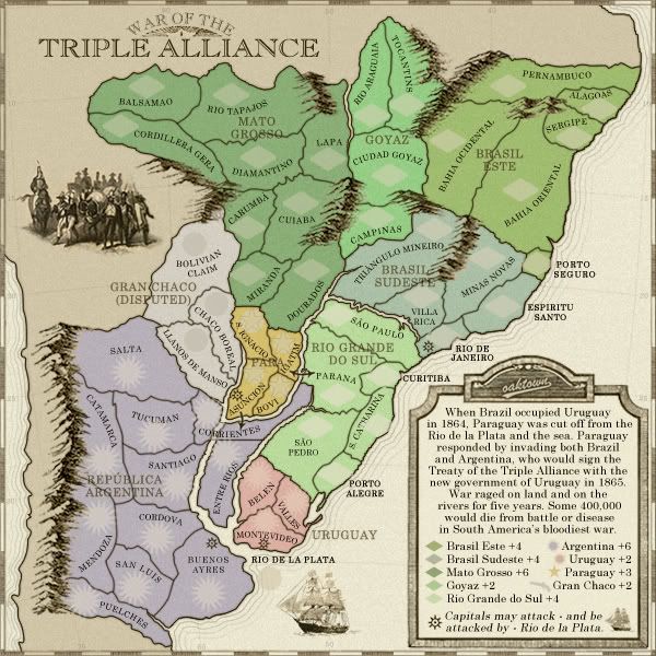
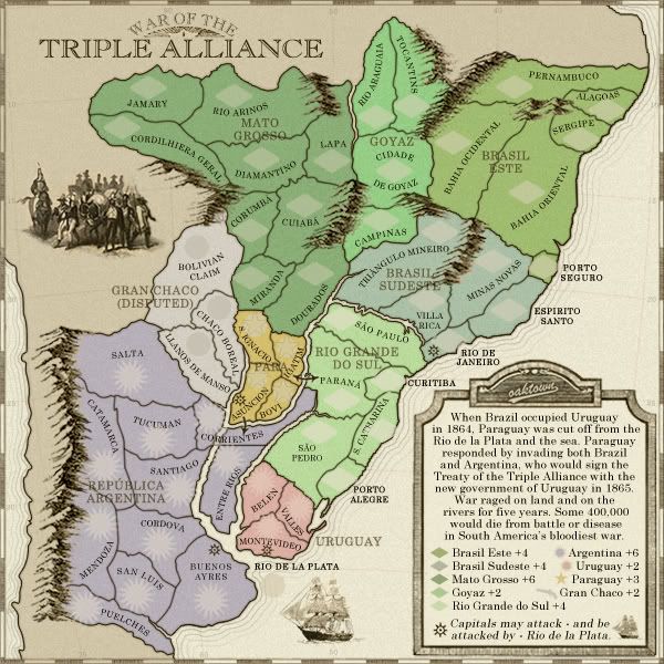
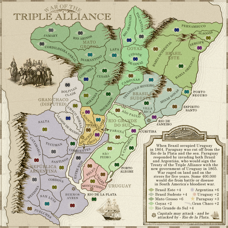
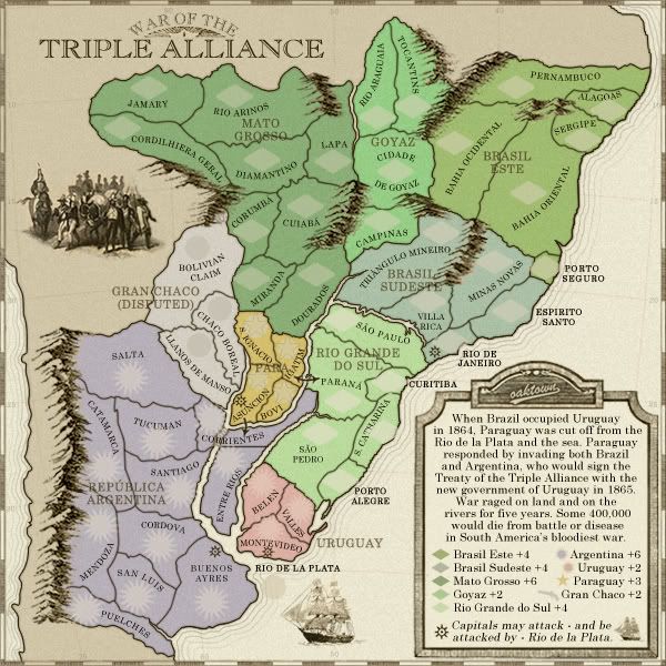
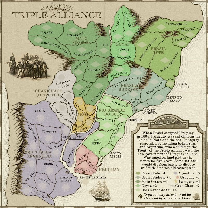
Large and small maps, no army counts... used these to center army coordinates, which is done (below). XML checks out with no errors. 
Fixed a few dumb things, like the punctuation.
Fixed a few dumb things, like the punctuation.
- Code: Select all
<?xml version="1.0"?>
<map>
<title>Alliance</title>
<smallwidth>600</smallwidth>
<smallheight>600</smallheight>
<largewidth>800</largewidth>
<largeheight>800</largeheight>
<filetype>jpg</filetype>
<continent>
<name>Mato Grosso</name>
<bonus>6</bonus>
<components>
<territory>Balsamao</territory>
<territory>Cordillera Gera</territory>
<territory>Rio Tapajos</territory>
<territory>Lapa</territory>
<territory>Diamantino</territory>
<territory>Cuiaba</territory>
<territory>Carumbá</territory>
<territory>Miranda</territory>
<territory>Dourados</territory>
</components>
</continent>
<continent>
<name>Goyaz</name>
<bonus>2</bonus>
<components>
<territory>Rio Araguaia</territory>
<territory>Tocantins</territory>
<territory>Ciudad Goyaz</territory>
<territory>Campinas</territory>
</components>
</continent>
<continent>
<name>Gran Chaco</name>
<bonus>2</bonus>
<components>
<territory>Bolivian Claim</territory>
<territory>Chaco Boreal</territory>
<territory>Llanos de Manso</territory>
</components>
</continent>
<continent>
<name>Brasil Este</name>
<bonus>4</bonus>
<components>
<territory>Pernambuco</territory>
<territory>Alagoas</territory>
<territory>Sergipe</territory>
<territory>Bahia Oriental</territory>
<territory>Bahia Ocidental</territory>
<territory>Porto Seguro</territory>
</components>
</continent>
<continent>
<name>Paraguay</name>
<bonus>3</bonus>
<components>
<territory>S. Ignacio</territory>
<territory>Igatim</territory>
<territory>Bovi</territory>
<territory>Asuncion</territory>
</components>
</continent>
<continent>
<name>Brasil Sudeste</name>
<bonus>4</bonus>
<components>
<territory>Triángulo Mineiro</territory>
<territory>Villa Rica</territory>
<territory>Rio de Janeiro</territory>
<territory>Minas Novas</territory>
<territory>Espiritu Santo</territory>
</components>
</continent>
<continent>
<name>Rio Grande do Sul</name>
<bonus>4</bonus>
<components>
<territory>São Paulo</territory>
<territory>Curitiba</territory>
<territory>Parana</territory>
<territory>S. Catharina</territory>
<territory>São Pedro</territory>
<territory>Porto Alegre</territory>
</components>
</continent>
<continent>
<name>Uruguay</name>
<bonus>2</bonus>
<components>
<territory>Belen</territory>
<territory>Valles</territory>
<territory>Montevideo</territory>
</components>
</continent>
<continent>
<name>Republica Argentina</name>
<bonus>6</bonus>
<components>
<territory>Salta</territory>
<territory>Tucuman</territory>
<territory>Catamarca</territory>
<territory>Corrientes</territory>
<territory>Entre Rios</territory>
<territory>Santiago</territory>
<territory>Cordova</territory>
<territory>Mendoza</territory>
<territory>San Luis</territory>
<territory>Puelches</territory>
<territory>Buenos Ayres</territory>
</components>
</continent>
<territory>
<name>Rio de la Plata</name>
<borders>
<border>Rio de Janeiro</border>
<border>Montevideo</border>
<border>Buenos Ayres</border>
<border>Asuncion</border>
</borders>
<coordinates>
<smallx>243</smallx>
<smally>549</smally>
<largex>326</largex>
<largey>721</largey>
</coordinates>
</territory>
<territory>
<name>Balsamao</name>
<borders>
<border>Rio Tapajos</border>
<border>Cordillera Gera</border>
</borders>
<coordinates>
<smallx>130</smallx>
<smally>101</smally>
<largex>175</largex>
<largey>128</largey>
</coordinates>
</territory>
<territory>
<name>Cordillera Gera</name>
<borders>
<border>Balsamao</border>
<border>Rio Tapajos</border>
<border>Diamantino</border>
</borders>
<coordinates>
<smallx>107</smallx>
<smally>137</smally>
<largex>143</largex>
<largey>176</largey>
</coordinates>
</territory>
<territory>
<name>Rio Tapajos</name>
<borders>
<border>Balsamao</border>
<border>Cordillera Gera</border>
<border>Diamantino</border>
<border>Lapa</border>
</borders>
<coordinates>
<smallx>208</smallx>
<smally>109</smally>
<largex>278</largex>
<largey>138</largey>
</coordinates>
</territory>
<territory>
<name>Diamantino</name>
<borders>
<border>Cordillera Gera</border>
<border>Rio Tapajos</border>
<border>Carumbá</border>
<border>Lapa</border>
<border>Cuiaba</border>
</borders>
<coordinates>
<smallx>233</smallx>
<smally>166</smally>
<largex>312</largex>
<largey>214</largey>
</coordinates>
</territory>
<territory>
<name>Lapa</name>
<borders>
<border>Rio Tapajos</border>
<border>Diamantino</border>
<border>Ciudad Goyaz</border>
<border>Cuiaba</border>
</borders>
<coordinates>
<smallx>296</smallx>
<smally>168</smally>
<largex>397</largex>
<largey>216</largey>
</coordinates>
</territory>
<territory>
<name>Carumbá</name>
<borders>
<border>Diamantino</border>
<border>Cuiaba</border>
<border>Miranda</border>
<border>Bolivian Claim</border>
</borders>
<coordinates>
<smallx>222</smallx>
<smally>230</smally>
<largex>298</largex>
<largey>300</largey>
</coordinates>
</territory> <territory>
<name>Cuiaba</name>
<borders>
<border>Diamantino</border>
<border>Miranda</border>
<border>Dourados</border>
<border>Carumbá</border>
<border>Lapa</border>
</borders>
<coordinates>
<smallx>271</smallx>
<smally>208</smally>
<largex>363</largex>
<largey>270</largey>
</coordinates>
</territory>
<territory>
<name>Miranda</name>
<borders>
<border>Chaco Boreal</border>
<border>Carumbá</border>
<border>Cuiaba</border>
<border>Dourados</border>
<border>Bolivian Claim</border>
<border>S. Ignacio</border>
</borders>
<coordinates>
<smallx>223</smallx>
<smally>273</smally>
<largex>298</largex>
<largey>357</largey>
</coordinates>
</territory>
<territory>
<name>Dourados</name>
<borders>
<border>Miranda</border>
<border>Campinas</border>
<border>Triángulo Mineiro</border>
<border>Igatim</border>
<border>Cuiaba</border>
<border>S. Ignacio</border>
</borders>
<coordinates>
<smallx>281</smallx>
<smally>269</smally>
<largex>376</largex>
<largey>352</largey>
</coordinates>
</territory>
<territory>
<name>Rio Araguaia</name>
<borders>
<border>Tocantins</border>
<border>Ciudad Goyaz</border>
</borders>
<coordinates>
<smallx>335</smallx>
<smally>127</smally>
<largex>449</largex>
<largey>163</largey>
</coordinates>
</territory>
<territory>
<name>Tocantins</name>
<borders>
<border>Rio Araguaia</border>
<border>Ciudad Goyaz</border>
</borders>
<coordinates>
<smallx>368</smallx>
<smally>118</smally>
<largex>492</largex>
<largey>150</largey>
</coordinates>
</territory>
<territory>
<name>Ciudad Goyaz</name>
<borders>
<border>Rio Araguaia</border>
<border>Tocantins</border>
<border>Campinas</border>
<border>Lapa</border>
<border>Bahia Ocidental</border>
</borders>
<coordinates>
<smallx>352</smallx>
<smally>182</smally>
<largex>471</largex>
<largey>236</largey>
</coordinates>
</territory>
<territory>
<name>Campinas</name>
<borders>
<border>Dourados</border>
<border>Ciudad Goyaz</border>
<border>Triángulo Mineiro</border>
</borders>
<coordinates>
<smallx>340</smallx>
<smally>221</smally>
<largex>455</largex>
<largey>288</largey>
</coordinates>
</territory>
<territory>
<name>Bahia Ocidental</name>
<borders>
<border>Pernambuco</border>
<border>Bahia Oriental</border>
<border>Ciudad Goyaz</border>
<border>Triángulo Mineiro</border>
</borders>
<coordinates>
<smallx>405</smallx>
<smally>151</smally>
<largex>542</largex>
<largey>194</largey>
</coordinates>
</territory>
<territory>
<name>Pernambuco</name>
<borders>
<border>Alagoas</border>
<border>Bahia Ocidental</border>
</borders>
<coordinates>
<smallx>461</smallx>
<smally>100</smally>
<largex>616</largex>
<largey>127</largey>
</coordinates>
</territory>
<territory>
<name>Alagoas</name>
<borders>
<border>Pernambuco</border>
<border>Sergipe</border>
</borders>
<coordinates>
<smallx>544</smallx>
<smally>121</smally>
<largex>727</largex>
<largey>155</largey>
</coordinates>
</territory>
<territory>
<name>Sergipe</name>
<borders>
<border>Alagoas</border>
<border>Bahia Oriental</border>
</borders>
<coordinates>
<smallx>521</smallx>
<smally>148</smally>
<largex>696</largex>
<largey>190</largey>
</coordinates>
</territory>
<territory>
<name>Bahia Oriental</name>
<borders>
<border>Sergipe</border>
<border>Bahia Ocidental</border>
<border>Porto Seguro</border>
<border>Minas Novas</border>
</borders>
<coordinates>
<smallx>472</smallx>
<smally>196</smally>
<largex>631</largex>
<largey>254</largey>
</coordinates>
</territory>
<territory>
<name>Porto Seguro</name>
<borders>
<border>Bahia Oriental</border>
<border>Minas Novas</border>
<border>Espiritu Santo</border>
</borders>
<coordinates>
<smallx>487</smallx>
<smally>263</smally>
<largex>651</largex>
<largey>344</largey>
</coordinates>
</territory>
<territory>
<name>Minas Novas</name>
<borders>
<border>Villa Rica</border>
<border>Espiritu Santo</border>
<border>Rio de Janeiro</border>
<border>Bahia Oriental</border>
<border>Porto Seguro</border>
</borders>
<coordinates>
<smallx>441</smallx>
<smally>258</smally>
<largex>590</largex>
<largey>337</largey>
</coordinates>
</territory>
<territory>
<name>Espiritu Santo</name>
<borders>
<border>Minas Novas</border>
<border>Rio de Janeiro</border>
<border>Porto Seguro</border>
</borders>
<coordinates>
<smallx>456</smallx>
<smally>302</smally>
<largex>609</largex>
<largey>396</largey>
</coordinates>
</territory>
<territory>
<name>Rio de Janeiro</name>
<borders>
<border>Villa Rica</border>
<border>Minas Novas</border>
<border>Espiritu Santo</border>
<border>São Paulo</border>
<border>Rio de la Plata</border>
</borders>
<coordinates>
<smallx>402</smallx>
<smally>330</smally>
<largex>537</largex>
<largey>433</largey>
</coordinates>
</territory>
<territory>
<name>Villa Rica</name>
<borders>
<border>Minas Novas</border>
<border>Rio de Janeiro</border>
<border>Triángulo Mineiro</border>
</borders>
<coordinates>
<smallx>382</smallx>
<smally>293</smally>
<largex>510</largex>
<largey>384</largey>
</coordinates>
</territory>
<territory>
<name>Triángulo Mineiro</name>
<borders>
<border>Villa Rica</border>
<border>Campinas</border>
<border>Bahia Ocidental</border>
<border>Dourados</border>
</borders>
<coordinates>
<smallx>393</smallx>
<smally>232</smally>
<largex>526</largex>
<largey>302</largey>
</coordinates>
</territory>
<territory>
<name>Bolivian Claim</name>
<borders>
<border>Chaco Boreal</border>
<border>Llanos de Manso</border>
<border>Carumbá</border>
<border>Miranda</border>
<border>Salta</border>
</borders>
<coordinates>
<smallx>174</smallx>
<smally>245</smally>
<largex>233</largex>
<largey>320</largey>
</coordinates>
</territory>
<territory>
<name>Chaco Boreal</name>
<borders>
<border>Bolivian Claim</border>
<border>Llanos de Manso</border>
<border>Miranda</border>
<border>S. Ignacio</border>
</borders>
<coordinates>
<smallx>194</smallx>
<smally>300</smally>
<largex>260</largex>
<largey>393</largey>
</coordinates>
</territory>
<territory>
<name>Llanos de Manso</name>
<borders>
<border>Chaco Boreal</border>
<border>Bolivian Claim</border>
<border>Salta</border>
<border>Corrientes</border>
</borders>
<coordinates>
<smallx>175</smallx>
<smally>333</smally>
<largex>235</largex>
<largey>437</largey>
</coordinates>
</territory>
<territory>
<name>S. Ignacio</name>
<borders>
<border>Asuncion</border>
<border>Igatim</border>
<border>Miranda</border>
<border>Dourados</border>
<border>Chaco Boreal</border>
</borders>
<coordinates>
<smallx>226</smallx>
<smally>317</smally>
<largex>303</largex>
<largey>415</largey>
</coordinates>
</territory>
<territory>
<name>Igatim</name>
<borders>
<border>S. Ignacio</border>
<border>Asuncion</border>
<border>Bovi</border>
<border>Dourados</border>
<border>Parana</border>
</borders>
<coordinates>
<smallx>255</smallx>
<smally>337</smally>
<largex>341</largex>
<largey>442</largey>
</coordinates>
</territory>
<territory>
<name>Bovi</name>
<borders>
<border>Igatim</border>
<border>Asuncion</border>
</borders>
<coordinates>
<smallx>252</smallx>
<smally>377</smally>
<largex>337</largex>
<largey>495</largey>
</coordinates>
</territory>
<territory>
<name>Asuncion</name>
<borders>
<border>S. Ignacio</border>
<border>Igatim</border>
<border>Bovi</border>
<border>Corrientes</border>
<border>Rio de la Plata</border>
</borders>
<coordinates>
<smallx>229</smallx>
<smally>364</smally>
<largex>306</largex>
<largey>478</largey>
</coordinates>
</territory>
<territory>
<name>São Paulo</name>
<borders>
<border>Curitiba</border>
<border>Parana</border>
<border>Rio de Janeiro</border>
</borders>
<coordinates>
<smallx>305</smallx>
<smally>311</smally>
<largex>409</largex>
<largey>409</largey>
</coordinates>
</territory>
<territory>
<name>Curitiba</name>
<borders>
<border>São Paulo</border>
<border>Parana</border>
<border>S. Catharina</border>
</borders>
<coordinates>
<smallx>348</smallx>
<smally>366</smally>
<largex>465</largex>
<largey>481</largey>
</coordinates>
</territory>
<territory>
<name>Parana</name>
<borders>
<border>São Paulo</border>
<border>Curitiba</border>
<border>S. Catharina</border>
<border>São Pedro</border>
<border>Igatim</border>
</borders>
<coordinates>
<smallx>305</smallx>
<smally>383</smally>
<largex>409</largex>
<largey>503</largey>
</coordinates>
</territory>
<territory>
<name>São Pedro</name>
<borders>
<border>Parana</border>
<border>S. Catharina</border>
<border>Porto Alegre</border>
<border>Belen</border>
<border>Valles</border>
</borders>
<coordinates>
<smallx>285</smallx>
<smally>413</smally>
<largex>381</largex>
<largey>543</largey>
</coordinates>
</territory>
<territory>
<name>Porto Alegre</name>
<borders>
<border>S. Catharina</border>
<border>São Pedro</border>
</borders>
<coordinates>
<smallx>304</smallx>
<smally>456</smally>
<largex>406</largex>
<largey>600</largey>
</coordinates>
</territory>
<territory>
<name>S. Catharina</name>
<borders>
<border>Parana</border>
<border>Curitiba</border>
<border>Porto Alegre</border>
<border>São Pedro</border>
</borders>
<coordinates>
<smallx>342</smallx>
<smally>412</smally>
<largex>457</largex>
<largey>541</largey>
</coordinates>
</territory>
<territory>
<name>Valles</name>
<borders>
<border>São Pedro</border>
<border>Belen</border>
<border>Montevideo</border>
</borders>
<coordinates>
<smallx>267</smallx>
<smally>481</smally>
<largex>357</largex>
<largey>634</largey>
</coordinates>
</territory>
<territory>
<name>Belen</name>
<borders>
<border>Valles</border>
<border>Montevideo</border>
<border>São Pedro</border>
</borders>
<coordinates>
<smallx>232</smallx>
<smally>458</smally>
<largex>311</largex>
<largey>604</largey>
</coordinates>
</territory>
<territory>
<name>Montevideo</name>
<borders>
<border>Belen</border>
<border>Valles</border>
<border>Rio de la Plata</border>
</borders>
<coordinates>
<smallx>239</smallx>
<smally>499</smally>
<largex>321</largex>
<largey>658</largey>
</coordinates>
</territory>
<territory>
<name>Buenos Ayres</name>
<borders>
<border>Cordova</border>
<border>San Luis</border>
<border>Rio de la Plata</border>
</borders>
<coordinates>
<smallx>187</smallx>
<smally>564</smally>
<largex>250</largex>
<largey>743</largey>
</coordinates>
</territory>
<territory>
<name>San Luis</name>
<borders>
<border>Buenos Ayres</border>
<border>Cordova</border>
<border>Puelches</border>
<border>Mendoza</border>
</borders>
<coordinates>
<smallx>120</smallx>
<smally>559</smally>
<largex>161</largex>
<largey>737</largey>
</coordinates>
</territory>
<territory>
<name>Puelches</name>
<borders>
<border>San Luis</border>
<border>Mendoza</border>
</borders>
<coordinates>
<smallx>73</smallx>
<smally>571</smally>
<largex>100</largex>
<largey>754</largey>
</coordinates>
</territory>
<territory>
<name>Mendoza</name>
<borders>
<border>San Luis</border>
<border>Cordova</border>
<border>Puelches</border>
<border>Catamarca</border>
</borders>
<coordinates>
<smallx>86</smallx>
<smally>495</smally>
<largex>117</largex>
<largey>652</largey>
</coordinates>
</territory>
<territory>
<name>Cordova</name>
<borders>
<border>Buenos Ayres</border>
<border>San Luis</border>
<border>Santiago</border>
<border>Mendoza</border>
<border>Catamarca</border>
</borders>
<coordinates>
<smallx>139</smallx>
<smally>514</smally>
<largex>187</largex>
<largey>679</largey>
</coordinates>
</territory>
<territory>
<name>Catamarca</name>
<borders>
<border>Cordova</border>
<border>Tucuman</border>
<border>Santiago</border>
<border>Mendoza</border>
<border>Salta</border>
</borders>
<coordinates>
<smallx>91</smallx>
<smally>444</smally>
<largex>124</largex>
<largey>584</largey>
</coordinates>
</territory>
<territory>
<name>Santiago</name>
<borders>
<border>Cordova</border>
<border>Tucuman</border>
<border>Catamarca</border>
<border>Corrientes</border>
</borders>
<coordinates>
<smallx>158</smallx>
<smally>464</smally>
<largex>212</largex>
<largey>610</largey>
</coordinates>
</territory>
<territory>
<name>Tucuman</name>
<borders>
<border>Corrientes</border>
<border>Salta</border>
<border>Catamarca</border>
<border>Santiago</border>
</borders>
<coordinates>
<smallx>137</smallx>
<smally>420</smally>
<largex>184</largex>
<largey>554</largey>
</coordinates>
</territory>
<territory>
<name>Salta</name>
<borders>
<border>Corrientes</border>
<border>Tucuman</border>
<border>Catamarca</border>
<border>Llanos de Manso</border>
<border>Bolivian Claim</border>
</borders>
<coordinates>
<smallx>113</smallx>
<smally>362</smally>
<largex>153</largex>
<largey>476</largey>
</coordinates>
</territory>
<territory>
<name>Corrientes</name>
<borders>
<border>Entre Rios</border>
<border>Salta</border>
<border>Tucuman</border>
<border>Santiago</border>
<border>Llanos de Manso</border>
</borders>
<coordinates>
<smallx>187</smallx>
<smally>400</smally>
<largex>251</largex>
<largey>526</largey>
</coordinates>
</territory>
<territory>
<name>Entre Rios</name>
<borders>
<border>Corrientes</border>
</borders>
<coordinates>
<smallx>202</smallx>
<smally>437</smally>
<largex>271</largex>
<largey>576</largey>
</coordinates>
</territory>
</map>
-

 oaktown
- Posts: 4451
- Joined: Sun Dec 03, 2006 9:24 pm
- Location: majorcommand


Re: War of the Triple Alliance; new update pg. 10 [D, Gp]
oaktown wrote:iancanton wrote:i've just realised that brasil este is a 3-border, 6-territory bonus region, just like classic africa, but with the added advantage of being in a corner and therefore not on an attack route between two bonus regions. should the bonus be +3 rather than +4?
I think that whether or not a 6 teritory, 3 border region is a +3 or a +4 depends on the rest of the map. This particular map is bigger than classic (52 v. 42), and contains two other similarly-sized +4 regions, as well as a four territory +3. Overall the bonuses are a bit higher here than what you see on classic, which I think is fine so long as they are in line with each other and no one region gives an unfair advantage.
that does seem to the case here. in fact, i must have taken this into account already on page 7!
iancanton wrote:the bonuses are well-balanced in both size and location.
one name change to make, from rio tapajos to rio arinos.
iancanton wrote:the river is actually called rio arinos till it flows into para state, where the name changes to tapajos
some spellings in investigate.
Lynx Cat wrote:Hello there, great job on the map! I'll grace it with my first post ever in Conquer Club. I don't know if there are any other Portuguese-speakers in this thread, so I'll go ahead and chime in about place names.
-"Balsamao" looks wrong, but I don't know what it is so I'll have to look it up
-"Cordilheira Geral", not "Cordillera Gera" (we don't speak Spanish!)
-"Corumbá" not "Carumbá"
-"Cuiabá" (accent)
-"Cidade de Goyaz" not "Ciudad" (again, no Spanish!)
-"Espirito Santo" not "Espiritu" (idem)
-"Paraná" (accent)
ian.
-

 iancanton
- Foundry Foreman

- Posts: 2432
- Joined: Fri Jun 01, 2007 5:40 am
- Location: europe


Re: War of the Triple Alliance; maps and code pg. 11 [D, Gp, Gr]
- Final Forge
---The War of the Triple Alliance Map has reached the ‘Final Forge’ Stage. I've revived this thread from the pits of the Foundry Furnace (okay, maybe not) and have examined the contents. Nearly every major concern has been addressed. If there are any other current concerns, please make your voice heard. If after a reasonable amount of time there has not been any objection or protest, the map will be deemed finished with the 'Foundry Brand' of approval and will be submitted for live play. As long as there is still discussion or posts that have yet to be commented on, the map will remain in Final Forge until said discussion has reached the conclusion that the map has reached its final and polished version.
Post questions and concerns if any.

--Andy
-

 AndyDufresne
- Posts: 24935
- Joined: Fri Mar 03, 2006 8:22 pm
- Location: A Banana Palm in Zihuatanejo


Re: War of the Triple Alliance; pg. 11 [Final Forge]
sure is a beauty oak. And look at those mountains - great work 

-

 RjBeals
- Posts: 2506
- Joined: Mon Nov 20, 2006 5:17 pm
- Location: South Carolina, USA


Re: War of the Triple Alliance; pg. 11 [Final Forge]
Not sure if anyone's mentioned this - but what's the rationale between using "Brazil" & "Brasil"?
C.
C.

Highest score : 2297
-

 yeti_c
- Posts: 9624
- Joined: Thu Jan 04, 2007 9:02 am


Re: War of the Triple Alliance; pg. 11 [Final Forge]
yeti_c wrote:Not sure if anyone's mentioned this - but what's the rationale between using "Brazil" & "Brasil"?
C.
Its Brasil in Portuguese, Brazil in English. When he writes about it in the legend he has to write in English, but the continents are named as it would be. Thats my assumption at least.
-

 foregone
- Posts: 289
- Joined: Sun May 11, 2008 1:00 am
- Location: Sydney, NSW, Australia


Re: War of the Triple Alliance; pg. 11 [Final Forge]
RjBeals wrote:And look at those mountains - great work
Enjoy that moment oak, its not often you get this with your mountains
What do you know about map making, bitch?
Top Score:2403
natty_dread wrote:I was wrong
Top Score:2403
-

 gimil
gimil
- Posts: 8599
- Joined: Sat Mar 03, 2007 12:42 pm
- Location: United Kingdom (Scotland)


Re: War of the Triple Alliance; pg. 11 [Final Forge]
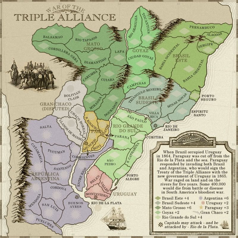
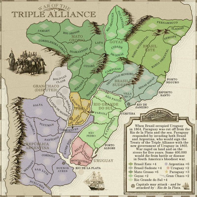
Alright, after a lengthy hiatus I have decided to knock this map out. What I've done:
• Corrected the brazilian spelling as per the earlier suggestions
• Renamed Rio Tapajas to Rio Aranos
• Renamed Balsamao to Jamary, after the river running through that region... there really wasn't much going on there in 1860, so finding a name that was applied consistently to anything in that region then has been a bitch. Jamary is as good as any I think.
• Updated the XML, and fixed a link I had originally missed.
Four images follow: large and small without coordinates, large and small showing coordinate centering.
XML can be found here, in case somebody wants to check connections:
http://www.fileden.com/files/2008/7/30/ ... liance.xml
-

 oaktown
- Posts: 4451
- Joined: Sun Dec 03, 2006 9:24 pm
- Location: majorcommand


Re: War of the Triple Alliance; pg. 11 [Final Forge]
gimil wrote:RjBeals wrote:And look at those mountains - great work
Enjoy that moment oak, its not often you get this with your mountains
Scotland, beeyotch.
-

 oaktown
- Posts: 4451
- Joined: Sun Dec 03, 2006 9:24 pm
- Location: majorcommand


Re: War of the Triple Alliance; pg. 11 [Final Forge]
Why is there are line dividing the river just before the split at corrientes and right where the territory borders Santiago as well? I think you did not erase the layer with the territory on that segment of the river that runs through it, since it is darker as well, and the lines that run across seem like that the territory lines would be.
If this was intentional to show that the territory was on both sides of the river, ignore that.
If this was intentional to show that the territory was on both sides of the river, ignore that.
-

 The Neon Peon
- Posts: 2342
- Joined: Sat Jun 14, 2008 12:49 pm


Re: War of the Triple Alliance; pg. 11 [Final Forge]
The Neon Peon wrote:Why is there are line dividing the river just before the split at corrientes and right where the territory borders Santiago as well? I think you did not erase the layer with the territory on that segment of the river that runs through it, since it is darker as well, and the lines that run across seem like that the territory lines would be.
If this was intentional to show that the territory was on both sides of the river, ignore that.
It's the latter. The concern has been duly ignored.
-

 oaktown
- Posts: 4451
- Joined: Sun Dec 03, 2006 9:24 pm
- Location: majorcommand


Re: War of the Triple Alliance; pg. 11 [Final Forge]
oaktown wrote:The Neon Peon wrote:Why is there are line dividing the river just before the split at corrientes and right where the territory borders Santiago as well? I think you did not erase the layer with the territory on that segment of the river that runs through it, since it is darker as well, and the lines that run across seem like that the territory lines would be.
If this was intentional to show that the territory was on both sides of the river, ignore that.
It's the latter. The concern has been duly ignored.
Hmmm... that little bit of passable river does look a little odd.... I wonder if there is any way to make it look less like an honest mistake?

PB: 2661 | He's blue... If he were green he would die | No mod would be stupid enough to do that
-

 MrBenn
- Posts: 6880
- Joined: Wed Nov 21, 2007 9:32 am
- Location: Off Duty


Re: War of the Triple Alliance; pg. 11 [Final Forge]
MrBenn wrote:Hmmm... that little bit of passable river does look a little odd.... I wonder if there is any way to make it look less like an honest mistake?
here's one idea I think light lines look better than just extending the borders across the river... I'm open to other ideas, but in the end all that matters is that it is clear that Corrientes crosses the river, which I think is clear here.
-

 oaktown
- Posts: 4451
- Joined: Sun Dec 03, 2006 9:24 pm
- Location: majorcommand


Re: War of the Triple Alliance; terit names pg. 12 [Final Forge]
Another possibility is to put the "Corrientes" name straight on a line without bending and draw some kind of bridge ][ under it with the blue colour inside.
De gueules à la tour d'argent ouverte, crénelée de trois pièces, sommée d'un donjon ajouré, crénelé de deux pièces
Gules an open tower silver, crenellated three parts, topped by a apertured turret, crenellated two parts
Gules an open tower silver, crenellated three parts, topped by a apertured turret, crenellated two parts
-

 pamoa
pamoa
- Posts: 1242
- Joined: Sat Sep 01, 2007 3:18 am
- Location: Confederatio Helvetica


Re: War of the Triple Alliance; terit names pg. 12 [Final Forge]
pamoa wrote:Another possibility is to put the "Corrientes" name straight on a line without bending and draw some kind of bridge ][ under it with the blue colour inside.
Hmmm... alright...
-

 oaktown
- Posts: 4451
- Joined: Sun Dec 03, 2006 9:24 pm
- Location: majorcommand


Re: War of the Triple Alliance; terit names pg. 12 [Final Forge]
I think that looks a lot "busier".
C.
C.

Highest score : 2297
-

 yeti_c
- Posts: 9624
- Joined: Thu Jan 04, 2007 9:02 am


Who is online
Users browsing this forum: No registered users

