Conquer Club

Michigan

Have an idea for a map? Discuss ideas and concepts here.

Moderator: Cartographers

Forum rules
Please read the Community Guidelines before posting.

Re: MICHIGAN MAP!

Postby 40kguy on Wed Apr 20, 2011 4:14 pm

rdsrds2120 wrote:
Riskismy wrote:I think it looks nice.
Now to think up some interesting gameplay! :-)


lol thanks. This was my first time using GIMP...ever. So, I got most of it from natty's guide. 40k wanted me to do the XML, but I got bored and tried for myself 8)

There's obviously a lot to add. Legend..impassables (rivers, I was thinking), and maybe boats connecting to the UP for gameplay's sake.

-rd

I think i can do most of that.
Image
16:00:18 ‹Pixar› Valentines Day the one day in they year that the V and the D come together
User avatar
Cook 40kguy
 
Posts: 1772
Joined: Mon Dec 29, 2008 11:39 am

Re: MICHIGAN MAP!

Postby 40kguy on Wed Apr 20, 2011 4:21 pm

rdsrds2120 wrote:
Riskismy wrote:I think it looks nice.
Now to think up some interesting gameplay! :-)


lol thanks. This was my first time using GIMP...ever. So, I got most of it from natty's guide. 40k wanted me to do the XML, but I got bored and tried for myself 8)

There's obviously a lot to add. Legend..impassables (rivers, I was thinking), and maybe boats connecting to the UP for gameplay's sake.

-rd

maybe mackinal bridge to.
Image
16:00:18 ‹Pixar› Valentines Day the one day in they year that the V and the D come together
User avatar
Cook 40kguy
 
Posts: 1772
Joined: Mon Dec 29, 2008 11:39 am

Re: MICHIGAN MAP!

Postby Victor Sullivan on Wed Apr 20, 2011 4:57 pm

First off, you're missing a bonus structure and impassables. Secondly, why would I or anyone not from Michigan want to play this? You need fresh gameplay to make this work.
User avatar
Corporal Victor Sullivan
 
Posts: 6010
Joined: Mon Feb 08, 2010 8:17 pm
Location: Columbus, OH

Re: MICHIGAN MAP!

Postby mviola on Wed Apr 20, 2011 5:01 pm

I'm in Michigan and I don't want to play this. Michigan has no impassables, is relatively flat, and doesn't really lend itself to a map.
High Score: 2906
User avatar
Major mviola
 
Posts: 847
Joined: Sat Nov 07, 2009 1:52 pm
Location: Ann Arbor, MI/NY

Re: MICHIGAN MAP!

Postby 40kguy on Wed Apr 20, 2011 5:03 pm

mviola wrote:I'm in Michigan and I don't want to play this. Michigan has no impassables, is relatively flat, and doesn't really lend itself to a map.

what have they teched you in school? no matter where you are in michigan you cant travel a mile or 8 miles, or something like that and reach water, up north there are some very nice mountins.
Image
16:00:18 ‹Pixar› Valentines Day the one day in they year that the V and the D come together
User avatar
Cook 40kguy
 
Posts: 1772
Joined: Mon Dec 29, 2008 11:39 am

Re: MICHIGAN MAP!

Postby mviola on Wed Apr 20, 2011 5:15 pm

The Lower Peninsula, shaped like a mitten, is 277 miles (446 km) long from north to south and 195 miles (314 km) from east to west and occupies nearly two-thirds of the state's land area. The surface of the peninsula is generally level, broken by conical hills and glacial moraines usually not more than a few hundred feet tall. It is divided by a low water divide running north and south. The larger portion of the state is on the west of this and gradually slopes toward Lake Michigan. The highest point in the Lower Peninsula is either Briar Hill at 1,705 feet (520 m), or one of several points nearby in the vicinity of Cadillac. The lowest point is the surface of Lake Erie at 571 feet (174 m).


The high point of the state is only about 2,000 feet and that's in the UP, as are most of them. And the longest river is about 250 miles long, so its not even that big either. I certainly had never heard of it before looking it up on Wikipedia.

And I'm from New York so I was taught about my state. We have the Hudson River, which is identifiable because of NYC and when you travel upstate, you hit mountains everywhere, many in excess of 4,000 feet.
High Score: 2906
User avatar
Major mviola
 
Posts: 847
Joined: Sat Nov 07, 2009 1:52 pm
Location: Ann Arbor, MI/NY

Re: MICHIGAN MAP!

Postby 40kguy on Wed Apr 20, 2011 5:29 pm

mviola wrote:
The Lower Peninsula, shaped like a mitten, is 277 miles (446 km) long from north to south and 195 miles (314 km) from east to west and occupies nearly two-thirds of the state's land area. The surface of the peninsula is generally level, broken by conical hills and glacial moraines usually not more than a few hundred feet tall. It is divided by a low water divide running north and south. The larger portion of the state is on the west of this and gradually slopes toward Lake Michigan. The highest point in the Lower Peninsula is either Briar Hill at 1,705 feet (520 m), or one of several points nearby in the vicinity of Cadillac. The lowest point is the surface of Lake Erie at 571 feet (174 m).


The high point of the state is only about 2,000 feet and that's in the UP, as are most of them. And the longest river is about 250 miles long, so its not even that big either. I certainly had never heard of it before looking it up on Wikipedia.

And I'm from New York so I was taught about my state. We have the Hudson River, which is identifiable because of NYC and when you travel upstate, you hit mountains everywhere, many in excess of 4,000 feet.

Oh I see what your saying. Hmm I think we can fine something to use as impassibles.
Image
16:00:18 ‹Pixar› Valentines Day the one day in they year that the V and the D come together
User avatar
Cook 40kguy
 
Posts: 1772
Joined: Mon Dec 29, 2008 11:39 am

Re: MICHIGAN MAP!

Postby rdsrds2120 on Wed Apr 20, 2011 5:31 pm

mviola wrote:I'm in Michigan and I don't want to play this. Michigan has no impassables, is relatively flat, and doesn't really lend itself to a map.


Rivers. We have lots, and lots of rivers. I live here, too :P

Major interstates could also be incorporated as blocks. I-69 and I-75 both run through here, which could be interesting.
Image

-rd
User avatar
Corporal 1st Class rdsrds2120
 
Posts: 6274
Joined: Fri Jul 03, 2009 3:42 am

Re: MICHIGAN MAP!

Postby 40kguy on Wed Apr 20, 2011 5:54 pm

rdsrds2120 wrote:
mviola wrote:I'm in Michigan and I don't want to play this. Michigan has no impassables, is relatively flat, and doesn't really lend itself to a map.


Rivers. We have lots, and lots of rivers. I live here, too :P

Major interstates could also be incorporated as blocks. I-69 and I-75 both run through here, which could be interesting.
Image

-rd

Yea. Those are some nice features
Image
16:00:18 ‹Pixar› Valentines Day the one day in they year that the V and the D come together
User avatar
Cook 40kguy
 
Posts: 1772
Joined: Mon Dec 29, 2008 11:39 am

Re: MICHIGAN MAP!

Postby rdsrds2120 on Wed Apr 20, 2011 8:11 pm

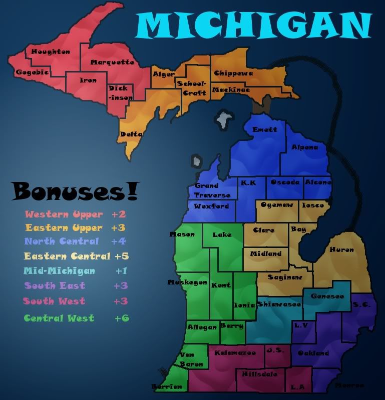
Click image to enlarge.
image


Do we like this one better than the last? I:
  • Added something that resembles a bonus table :lol: and
  • changed the glow to come from that. It's a pretty strong one, too.
  • also shrank the font and moved some names around.
  • Split the UP into two separate bonuses.
  • Added a North/South bridge -- I plan to have ports or something around the coastlines in the future...but let's not get too far ahead.

-rd
User avatar
Corporal 1st Class rdsrds2120
 
Posts: 6274
Joined: Fri Jul 03, 2009 3:42 am

Re: MICHIGAN MAP!

Postby 40kguy on Wed Apr 20, 2011 8:19 pm

rdsrds2120 wrote:Image

Do we like this one better than the last? I:
  • Added something that resembles a bonus table :lol: and
  • changed the glow to come from that. It's a pretty strong one, too.
  • also shrank the font and moved some names around.
  • Split the UP into two separate bonuses.
  • Added a North/South bridge -- I plan to have ports or something around the coastlines in the future...but let's not get too far ahead.

-rd

How about you make the sea routes better. It tells you how to do it in the tutorial
Image
16:00:18 ‹Pixar› Valentines Day the one day in they year that the V and the D come together
User avatar
Cook 40kguy
 
Posts: 1772
Joined: Mon Dec 29, 2008 11:39 am

Re: MICHIGAN MAP!

Postby rdsrds2120 on Wed Apr 20, 2011 8:24 pm

40kguy wrote:
rdsrds2120 wrote:Do we like this one better than the last? I:
  • Added something that resembles a bonus table :lol: and
  • changed the glow to come from that. It's a pretty strong one, too.
  • also shrank the font and moved some names around.
  • Split the UP into two separate bonuses.
  • Added a North/South bridge -- I plan to have ports or something around the coastlines in the future...but let's not get too far ahead.

-rd

How about you make the sea routes better. It tells you how to do it in the tutorial


I want to make sure we can agree they're in the right place before I make them really nice, because then they'd probably be harder to edit later on. Remember, we're not even in the gameplay section yet, so graphics isn't really necessary atm :)

-rd
User avatar
Corporal 1st Class rdsrds2120
 
Posts: 6274
Joined: Fri Jul 03, 2009 3:42 am

Re: MICHIGAN MAP!

Postby 40kguy on Wed Apr 20, 2011 8:46 pm

rdsrds2120 wrote:
40kguy wrote:
rdsrds2120 wrote:Do we like this one better than the last? I:
  • Added something that resembles a bonus table :lol: and
  • changed the glow to come from that. It's a pretty strong one, too.
  • also shrank the font and moved some names around.
  • Split the UP into two separate bonuses.
  • Added a North/South bridge -- I plan to have ports or something around the coastlines in the future...but let's not get too far ahead.

-rd

How about you make the sea routes better. It tells you how to do it in the tutorial


I want to make sure we can agree they're in the right place before I make them really nice, because then they'd probably be harder to edit later on. Remember, we're not even in the gameplay section yet, so graphics isn't really necessary atm :)
Well then. You need a lot more ways to the UP. Maybe boats, boats, mackinaw brige. We might be able to make that a region. Idk, you had some very good ways.
-rd
Image
16:00:18 ‹Pixar› Valentines Day the one day in they year that the V and the D come together
User avatar
Cook 40kguy
 
Posts: 1772
Joined: Mon Dec 29, 2008 11:39 am

Re: MICHIGAN MAP!

Postby mviola on Wed Apr 20, 2011 9:19 pm

I like how the UP is now 2 bonus regions. It would have never factored into the game as one. Also, it's not important right now but I there should be an abbreviation list. I'm in Ann Arbor right now, and I can't tell what they are, even though I'm in the area.
High Score: 2906
User avatar
Major mviola
 
Posts: 847
Joined: Sat Nov 07, 2009 1:52 pm
Location: Ann Arbor, MI/NY

Re: MICHIGAN MAP!

Postby rdsrds2120 on Wed Apr 20, 2011 9:55 pm

I noticed that when I posted that. I've made some changes and will get to the abbrev list soon (probably the next update). I'm really liking the idea of the roads being impassables (with some holes, of course). I need to fix the whole Oakland mess that's down there, and the green area doesn't look very playable, ether. The newer version already isn't as dark.

-rd
User avatar
Corporal 1st Class rdsrds2120
 
Posts: 6274
Joined: Fri Jul 03, 2009 3:42 am

Re: MICHIGAN MAP!

Postby natty dread on Wed Apr 20, 2011 11:59 pm

rdsrds2120 wrote:I want to make sure we can agree they're in the right place before I make them really nice, because then they'd probably be harder to edit later on.


If you follow my tutorials, and keep all the layers you create separate (except where otherwise mentioned) and don't take any shortcuts, then you will have an image file which is easy to edit and change later. This is the beauty of layer-based image-editing, you can change an element of an image any time without it affecting the rest of the image. The tutorial is designed to create a dynamic graphics file which allows easy editing.

rdsrds2120 wrote:Remember, we're not even in the gameplay section yet, so graphics isn't really necessary atm :)


Actually, you will be expected to get your graphics at a certain level even before gameplay. Firstly, you have to create a working draft, which is a map image that includes all elements needed to play the map. Territory names, bonus names & values, legends, title, impassables, etc. Secondly, before moving up to gameplay, the image should be of certain quality: it should have a clean look, no overly pixelated edges, no colour bleed, no blurryness or mspaint-ness.

As for the current map image... some points:

- You've overdone the gradient overlay a bit, I suggest toning it down somewhat - the areas near the map edges are hard to see, especially the lower right corner.

- That font you have... well, let me put it like this: beginning graphic designers often like to use "fun" & "whimsical" fonts like this, even when most of the time a clean, evenly kerned, easy to read font would do much better. The font you have is ok for the title, for all the other text, I suggest finding something more easy on the eyes.

- Borders... why are they grey? Also, the inner territory borders look sort of hastily made. The 2nd part of my tutorial has a section on drawing borders with the path tool. It takes some practice to learn to use the path tool, but it's well worth it in the end.
Image
User avatar
Sergeant 1st Class natty dread
 
Posts: 12877
Joined: Fri Feb 08, 2008 8:58 pm
Location: just plain fucked

Re: MICHIGAN MAP!

Postby rdsrds2120 on Thu Apr 21, 2011 8:36 am

natty_dread wrote:
rdsrds2120 wrote:I want to make sure we can agree they're in the right place before I make them really nice, because then they'd probably be harder to edit later on.


If you follow my tutorials, and keep all the layers you create separate (except where otherwise mentioned) and don't take any shortcuts, then you will have an image file which is easy to edit and change later. This is the beauty of layer-based image-editing, you can change an element of an image any time without it affecting the rest of the image. The tutorial is designed to create a dynamic graphics file which allows easy editing.


I meant bending a curve and things like that. I'm thinking of using a "port" system instead, anyways, instead of attack routes between the areas.

rdsrds2120 wrote:Remember, we're not even in the gameplay section yet, so graphics isn't really necessary atm :)


Actually, you will be expected to get your graphics at a certain level even before gameplay. Firstly, you have to create a working draft, which is a map image that includes all elements needed to play the map. Territory names, bonus names & values, legends, title, impassables, etc. Secondly, before moving up to gameplay, the image should be of certain quality: it should have a clean look, no overly pixelated edges, no colour bleed, no blurryness or mspaint-ness.


Alright, thanks!

As for the current map image... some points:

- You've overdone the gradient overlay a bit, I suggest toning it down somewhat - the areas near the map edges are hard to see, especially the lower right corner.

-Thanks, I have it toned down in the next one.

- That font you have... well, let me put it like this: beginning graphic designers often like to use "fun" & "whimsical" fonts like this, even when most of the time a clean, evenly kerned, easy to read font would do much better. The font you have is ok for the title, for all the other text, I suggest finding something more easy on the eyes.

-That's more than reasonable. I found it for the title and didn't have much of a clue to change it, but all my names are layered, so I can go and edit them pretty quick.

- Borders... why are they grey? Also, the inner territory borders look sort of hastily made. The 2nd part of my tutorial has a section on drawing borders with the path tool. It takes some practice to learn to use the path tool, but it's well worth it in the end.

-Yes. Especially around Oakland and Kent. After I uploaded that version and looked at it, I kind of grimaced for not getting them in the beginning. However, switching to a smaller font size from the very first draft made it easier to move around names and not use as many abbreviations, which I need to make a list for, anyways.What do you mean "why are the borders gray?" Should they not be? I think I'd have to use a darker color to fill them in, so I'm not sure quite exactly what you mean. They're black when I have GIMP open, anyway, so they're probably just gray in that one from double gradient I had going on.


Thanks for your tips, natty. I used your first guide to get a lot of it done. I'll go back and look at 2 and see what I can improve on. Seeya,

-rd
User avatar
Corporal 1st Class rdsrds2120
 
Posts: 6274
Joined: Fri Jul 03, 2009 3:42 am

Re: MICHIGAN MAP!

Postby grifftron on Thu Apr 21, 2011 10:12 am

why dont you update the first post if you changed maps
Image
User avatar
Major grifftron
SoC Training Adviser
 
Posts: 3280
Joined: Thu Jul 09, 2009 6:11 am

Re: MICHIGAN MAP!

Postby rdsrds2120 on Thu Apr 21, 2011 10:50 am

grifftron wrote:why dont you update the first post if you changed maps


Because I just got this switched to my name :P

-rd
User avatar
Corporal 1st Class rdsrds2120
 
Posts: 6274
Joined: Fri Jul 03, 2009 3:42 am

Re: MICHIGAN MAP!

Postby rdsrds2120 on Thu Apr 21, 2011 1:11 pm

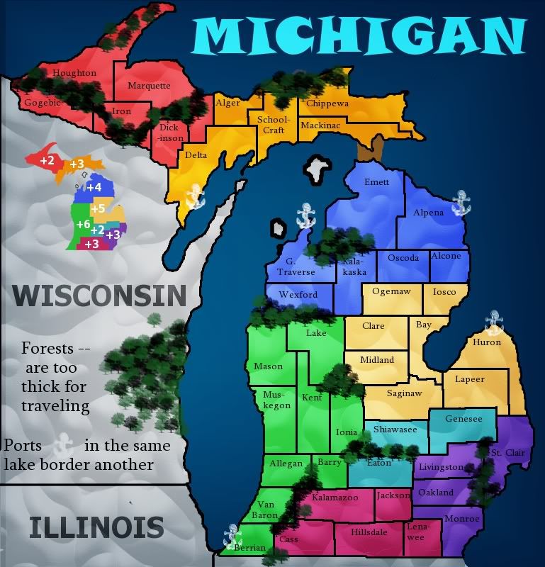
So I added some things to try and give it some gameplay features. I need to add in Canada in the Northeast and specify the lakes. The current ports I was thinking of having as starting neutrals. Forests are more than negotiable, of course. I plan to remove a lot of the southern ones once I put on the interstates and change some stuff around as far as impassables go. Does anyone think this has potential enough to go forward?

-rd
User avatar
Corporal 1st Class rdsrds2120
 
Posts: 6274
Joined: Fri Jul 03, 2009 3:42 am

Re: MICHIGAN MAP!

Postby natty dread on Thu Apr 21, 2011 1:22 pm

You'll get more comments if people don't have to scroll back to page 1... It's always good to post updates in "both ends" of the thread.
Image
User avatar
Sergeant 1st Class natty dread
 
Posts: 12877
Joined: Fri Feb 08, 2008 8:58 pm
Location: just plain fucked

Re: MICHIGAN MAP!

Postby 40kguy on Thu Apr 21, 2011 2:10 pm

I like the new map. much better then mine.
Image
16:00:18 ‹Pixar› Valentines Day the one day in they year that the V and the D come together
User avatar
Cook 40kguy
 
Posts: 1772
Joined: Mon Dec 29, 2008 11:39 am

Re: MICHIGAN MAP!

Postby rdsrds2120 on Thu Apr 21, 2011 2:13 pm

natty_dread wrote:You'll get more comments if people don't have to scroll back to page 1... It's always good to post updates in "both ends" of the thread.


Okie dokie.

Click image to enlarge.
image


There it is at both ends! :P

-rd
User avatar
Corporal 1st Class rdsrds2120
 
Posts: 6274
Joined: Fri Jul 03, 2009 3:42 am

Re: MICHIGAN MAP!

Postby mviola on Thu Apr 21, 2011 2:18 pm

It looks weird having Illinois and Wisconsin on the map, and not Canada. Also I think you should put the border of Indiana and Ohio in.
High Score: 2906
User avatar
Major mviola
 
Posts: 847
Joined: Sat Nov 07, 2009 1:52 pm
Location: Ann Arbor, MI/NY

Re: MICHIGAN MAP!

Postby natty dread on Thu Apr 21, 2011 2:26 pm

Ok... Iron & Marquette seem to be weirdly "split" by the forests... makes the map a bit unclear. Perhaps you can cut the forest so that the territories stay whole?

Also, when you redo the borders... it's a good idea to make the borders between bonus areas slightly thicker than borders between territories.
Image
User avatar
Sergeant 1st Class natty dread
 
Posts: 12877
Joined: Fri Feb 08, 2008 8:58 pm
Location: just plain fucked

PreviousNext

Return to Melting Pot: Map Ideas

Who is online

Users browsing this forum: No registered users