Conquer Club

A New World: a project in cartography, Usergroup made!

Have an idea for a map? Discuss ideas and concepts here.

Moderator: Cartographers

Forum rules
Please read the Community Guidelines before posting.

Re: A New World: a project in cartography

Postby demonfork on Mon Jan 04, 2010 3:08 am

mibi wrote:
captainwalrus wrote:
TaCktiX wrote:Sounds like mibi's Epoch from 2-3 years ago. Same general idea, though mibi was planning on being the sole author of the maps. If this idea is still kicking in March, I create a mean mythology and history for fake regions.

EDIT: Proof (here) and (here).

Yeah I kinda got the idea from Mibi's Epoch, but that was like 9 people making parts which just make up one map. Which is big, but I am, wanting to go even bigger.


you want to be careful not to bite off more than what is managable. given the nature of the foundry, it's speed and process, you might end up with a spruce goose.


The Spruce Goose was badass.
Image
User avatar
Lieutenant demonfork
 
Posts: 2214
Joined: Wed Jun 18, 2008 4:52 pm
Location: Your moms house

Re: A New World: a project in cartography

Postby YKenneth on Mon Jan 04, 2010 3:35 am

I'd like to help in brainstorming and history, I'm a fraid I can't do much with cartography.
Lieutenant YKenneth
 
Posts: 4
Joined: Wed Sep 30, 2009 7:35 pm

Re: A New World: a project in cartography

Postby natty dread on Mon Jan 04, 2010 6:32 am

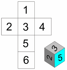
john9blue wrote:We could make 6 maps each representing part of the globe. The edges would be connected like a cube folded up...

Image

Whatever you do I wish you luck. I might contribute to this if I find time. 8-)


I'd rather go with 4 quadrants of a sphere... I've never seen a square planet :mrgreen:
Image
User avatar
Sergeant 1st Class natty dread
 
Posts: 12877
Joined: Fri Feb 08, 2008 8:58 pm
Location: just plain fucked

Re: A New World: a project in cartography

Postby colton24 on Mon Jan 04, 2010 9:35 am

natty_dread wrote:
john9blue wrote:We could make 6 maps each representing part of the globe. The edges would be connected like a cube folded up...

Image

Whatever you do I wish you luck. I might contribute to this if I find time. 8-)


I'd rather go with 4 quadrants of a sphere... I've never seen a square planet :mrgreen:


Yeah. I don't think it'd be a good idea with squares
Highest Rank: Lieutenant | Highest Score: 1641
Mr. Squirrel wrote:
pmchugh wrote:BUMP- one more fool needed :mrgreen:

One fool reporting for duty!

Been around for too long...said things that shouldn't have been said...but all that has changed
User avatar
Corporal 1st Class colton24
 
Posts: 1935
Joined: Mon Jun 22, 2009 8:27 am
Location: Alabama

Re: A New World: a project in cartography

Postby natty dread on Mon Jan 04, 2010 9:39 am

4 quadrants:

Western half of Northern hemisphere
Eastern half of Northern hemisphere
Western half of Southern hemisphere
Eastern half of Southern hemisphere

each could have 1-2 continents.

btw I think we should start from top to bottom: first the world map, then the continent maps, then individual countries...
Image
User avatar
Sergeant 1st Class natty dread
 
Posts: 12877
Joined: Fri Feb 08, 2008 8:58 pm
Location: just plain fucked

Re: A New World: a project in cartography

Postby mibi on Mon Jan 04, 2010 9:44 am

demonfork wrote:
mibi wrote:
captainwalrus wrote:
TaCktiX wrote:Sounds like mibi's Epoch from 2-3 years ago. Same general idea, though mibi was planning on being the sole author of the maps. If this idea is still kicking in March, I create a mean mythology and history for fake regions.

EDIT: Proof (here) and (here).

Yeah I kinda got the idea from Mibi's Epoch, but that was like 9 people making parts which just make up one map. Which is big, but I am, wanting to go even bigger.


you want to be careful not to bite off more than what is managable. given the nature of the foundry, it's speed and process, you might end up with a spruce goose.


The Spruce Goose was badass.


yeah but not much replay value.
User avatar
Captain mibi
 
Posts: 3350
Joined: Thu Mar 01, 2007 8:19 pm
Location: The Great State of Vermont

Re: A New World: a project in cartography

Postby skeletonboy on Mon Jan 04, 2010 11:25 am

natty_dread wrote:4 quadrants:

Western half of Northern hemisphere
Eastern half of Northern hemisphere
Western half of Southern hemisphere
Eastern half of Southern hemisphere

each could have 1-2 continents.

btw I think we should start from top to bottom: first the world map, then the continent maps, then individual countries...


I agree, everyone can help on the main one, then split off into separate mini-maps.
User avatar
Sergeant skeletonboy
 
Posts: 364
Joined: Wed Oct 24, 2007 8:17 am
Location: With Jesus

Re: A New World: a project in cartography

Postby ender516 on Mon Jan 04, 2010 12:21 pm

natty_dread wrote:
john9blue wrote:We could make 6 maps each representing part of the globe. The edges would be connected like a cube folded up...

Image

Whatever you do I wish you luck. I might contribute to this if I find time. 8-)


I'd rather go with 4 quadrants of a sphere... I've never seen a square planet :mrgreen:

I think the cube idea is a better one, once you inflate the cube to be a sphere. (Think of the 3D FlowerBox screen saver on Windows systems.) You could have two polar maps (one continental like Antarctica, one maritime like the Arctic), and four wrapped around the equator. These six would be a solid basis for the continents of the world maps. Dividing a globe into four quadrants tends to leave lens-shaped divisions.

And anyone who has never seen a square planet obviously never read DC Comics: the planet Htrae, built by Bizarro #1, was a splendid big blue and green regular hexahedron (cube, that is).
User avatar
Sergeant 1st Class ender516
 
Posts: 4455
Joined: Wed Dec 17, 2008 6:07 pm
Location: Waterloo, Ontario

Re: A New World: a project in cartography

Postby sully800 on Mon Jan 04, 2010 1:10 pm

I'd say a lot of work needs to go into this project before trying to assemble individual maps. It would be a good idea to form a usergroup of the interested parties and kick around the ideas of theme for a while before trying to divide up the land and the different areas. Develop not only the geography, but storylines and history for this land as well. One of the big issues right now with so many ideas and no clear direction is the final project will have no uniformity and would not be any different than the current maps on CC.

Several items could be used to unify the maps in this series. A common border to the maps, or the same layout/color scheme. Perhaps all the titles have a similar convention like the Realm series. Anyway, my point is to continue doing discussion for quite a while because otherwise the project won't be as worthwhile.

It would also be good to start with a small goal - perhaps 1 map of the whole land with 6 small maps that are contained in that land. In addition to the initial goal you include ideas of how to expand it (additional lands, maps of the cities, etc) but don't start with such a large initial scope that the project becomes overwhelming.

As for theme, I kind of like the idea of unifying existing CC maps but I was much more excited about this when I was thinking of it as a new fantasy land for traditional fantasy creatures. We could build our own Middle Earth (not actually LOTR themed, but just to explain the idea) with kingdoms for men, dwarves, elves, giants, cyclops, centaurs, goblins, wizards, trolls, dragons, etc. Within those kingdoms we could have nods to existing CC maps (feudal war within the kingdom of men for example) but I wouldn't rely too heavily on them since we don't know which maps would give permission. Once again, the more these maps are unified graphically and thematically the better the overall project would be.

This could also be a unique way to create the maps. To keep them all similar graphically it would be tough to use so many different cartographers. Instead, each artist could contribute the same pieces to all of the maps. One person creates the titles, one person creates the outer border and legend, one person is in charge of landscape and texture, one person does impassables. This would be nice because you could have the best artists take on the biggest portions and the less skilled could do smaller pieces but still have contributions. Once the theme is wrapped up and the geography determined it would be pretty fast to create these maps as long as the team works well together. And once the first one or two are completed the others would be even faster and better since the theme and overall graphics are already established.

That's my vision at least!
User avatar
Major sully800
 
Posts: 4978
Joined: Wed Jun 14, 2006 5:45 pm
Location: Bethlehem, Pennsylvania

Re: A New World: a project in cartography

Postby skeletonboy on Mon Jan 04, 2010 2:07 pm

sully800 wrote:I'd say a lot of work needs to go into this project before trying to assemble individual maps. It would be a good idea to form a usergroup of the interested parties and kick around the ideas of theme for a while before trying to divide up the land and the different areas. Develop not only the geography, but storylines and history for this land as well. One of the big issues right now with so many ideas and no clear direction is the final project will have no uniformity and would not be any different than the current maps on CC.

Several items could be used to unify the maps in this series. A common border to the maps, or the same layout/color scheme. Perhaps all the titles have a similar convention like the Realm series. Anyway, my point is to continue doing discussion for quite a while because otherwise the project won't be as worthwhile.

It would also be good to start with a small goal - perhaps 1 map of the whole land with 6 small maps that are contained in that land. In addition to the initial goal you include ideas of how to expand it (additional lands, maps of the cities, etc) but don't start with such a large initial scope that the project becomes overwhelming.

As for theme, I kind of like the idea of unifying existing CC maps but I was much more excited about this when I was thinking of it as a new fantasy land for traditional fantasy creatures. We could build our own Middle Earth (not actually LOTR themed, but just to explain the idea) with kingdoms for men, dwarves, elves, giants, cyclops, centaurs, goblins, wizards, trolls, dragons, etc. Within those kingdoms we could have nods to existing CC maps (feudal war within the kingdom of men for example) but I wouldn't rely too heavily on them since we don't know which maps would give permission. Once again, the more these maps are unified graphically and thematically the better the overall project would be.

This could also be a unique way to create the maps. To keep them all similar graphically it would be tough to use so many different cartographers. Instead, each artist could contribute the same pieces to all of the maps. One person creates the titles, one person creates the outer border and legend, one person is in charge of landscape and texture, one person does impassables. This would be nice because you could have the best artists take on the biggest portions and the less skilled could do smaller pieces but still have contributions. Once the theme is wrapped up and the geography determined it would be pretty fast to create these maps as long as the team works well together. And once the first one or two are completed the others would be even faster and better since the theme and overall graphics are already established.

That's my vision at least!


I like the idea of everyone doing a separate piece of the same map. I have wanted to do a map for a while but I havent had the confidance to do it alone so this is a good opportunity for me.
User avatar
Sergeant skeletonboy
 
Posts: 364
Joined: Wed Oct 24, 2007 8:17 am
Location: With Jesus

Re: A New World: a project in cartography

Postby natty dread on Mon Jan 04, 2010 3:27 pm

I'd be much happier if I were allowed to make the graphics to a map myself.

I don't like the idea of a horde of guys each doing a piece of a map... how to keep the visual style consistent?

And what about medals?

Maybe some of the more inexperienced can form teams lead by an experienced artist, but those who are capable of making good graphics by themselves should be allowed to make their own maps...

In a project this size, there will be stuff to do for everyone.

OK, the main world map could well be a collaboration of several people... but when it comes to the continents, I'd rather see them made by individual mapmakers.
Image
User avatar
Sergeant 1st Class natty dread
 
Posts: 12877
Joined: Fri Feb 08, 2008 8:58 pm
Location: just plain fucked

Re: A New World: a project in cartography

Postby skeletonboy on Mon Jan 04, 2010 3:34 pm

Also different maps will need different styles, for example a deserts title will be different to a city's which will be different to the main world map's.
User avatar
Sergeant skeletonboy
 
Posts: 364
Joined: Wed Oct 24, 2007 8:17 am
Location: With Jesus

Re: A New World: a project in cartography

Postby Evil DIMwit on Mon Jan 04, 2010 3:40 pm

sully800 wrote:This could also be a unique way to create the maps. To keep them all similar graphically it would be tough to use so many different cartographers. Instead, each artist could contribute the same pieces to all of the maps. One person creates the titles, one person creates the outer border and legend, one person is in charge of landscape and texture, one person does impassables.


I don't like this if it means we end up waiting on people for specific parts.


As for the cube/sphere debate: I'd be disappointed if our planet is so regular as to be divisible into six or four congruent sections. Continents, oceans, points of interest, etc. should be spread organically around a world, as they are around ours.
ImageImage
User avatar
Captain Evil DIMwit
 
Posts: 1616
Joined: Thu Mar 22, 2007 1:47 pm
Location: Philadelphia, NJ

Re: A New World: a project in cartography

Postby sully800 on Mon Jan 04, 2010 3:41 pm

Right, definitely all maps would have different styles, but if the same parts were made by the same artists they would be more consistent. I don't know if this would work with such a diverse group of mapmakers, but with a team that works well together I think it would certainly be the best way to create a consistent set of maps with multiple artists.
User avatar
Major sully800
 
Posts: 4978
Joined: Wed Jun 14, 2006 5:45 pm
Location: Bethlehem, Pennsylvania

Re: A New World: a project in cartography

Postby skeletonboy on Mon Jan 04, 2010 3:46 pm

Evil DIMwit wrote:
sully800 wrote:This could also be a unique way to create the maps. To keep them all similar graphically it would be tough to use so many different cartographers. Instead, each artist could contribute the same pieces to all of the maps. One person creates the titles, one person creates the outer border and legend, one person is in charge of landscape and texture, one person does impassables.


I don't like this if it means we end up waiting on people for specific parts.


As for the cube/sphere debate: I'd be disappointed if our planet is so regular as to be divisible into six or four congruent sections. Continents, oceans, points of interest, etc. should be spread organically around a world, as they are around ours.


I think it should be;
  • 1 world map
  • 3-4 continants
  • 5-6 cities, battle fields, plains, deserts etc
User avatar
Sergeant skeletonboy
 
Posts: 364
Joined: Wed Oct 24, 2007 8:17 am
Location: With Jesus

Re: A New World: a project in cartography

Postby john9blue on Mon Jan 04, 2010 3:47 pm

I think it would be more interesting to have a quilt-like map with a variety of different styles, rather than having the same style for all the maps.

Why don't we create a city/region and depict that city/region during different points of history? E.g. depict "Conqueropolis" or "Conqueria" as a European village/country during ancient times, the Middle Ages, the Renaissance, the industrial era, the modern era, and the future. 8-)
natty_dread wrote:Do ponies have sex?
Army of GOD wrote:the term heterosexual is offensive. I prefer to be called "normal"
(proud member of the Occasionally Wrongly Banned)
User avatar
Captain john9blue
 
Posts: 1268
Joined: Mon Aug 20, 2007 6:18 pm
Location: FlutterChi-town

Re: A New World: a project in cartography

Postby skeletonboy on Mon Jan 04, 2010 3:53 pm

john9blue wrote:I think it would be more interesting to have a quilt-like map with a variety of different styles, rather than having the same style for all the maps.

Why don't we create a city/region and depict that city/region during different points of history? E.g. depict "Conqueropolis" or "Conqueria" as a European village/country during ancient times, the Middle Ages, the Renaissance, the industrial era, the modern era, and the future. 8-)


I think that that would make all the maps a bit similar eg gameplay would be difficult to make different each time. I agree that there could be 1 or 2 of the same area at different points of history, but it could get too similar to the aor series.

EDIT: captainwalrus, do you realise that coming is spelt wrong in your signature?
User avatar
Sergeant skeletonboy
 
Posts: 364
Joined: Wed Oct 24, 2007 8:17 am
Location: With Jesus

Re: A New World: a project in cartography

Postby captainwalrus on Mon Jan 04, 2010 4:33 pm

sully800 wrote:I'd say a lot of work needs to go into this project before trying to assemble individual maps. It would be a good idea to form a usergroup of the interested parties and kick around the ideas of theme for a while before trying to divide up the land and the different areas. Develop not only the geography, but storylines and history for this land as well. One of the big issues right now with so many ideas and no clear direction is the final project will have no uniformity and would not be any different than the current maps on CC.

Several items could be used to unify the maps in this series. A common border to the maps, or the same layout/color scheme. Perhaps all the titles have a similar convention like the Realm series. Anyway, my point is to continue doing discussion for quite a while because otherwise the project won't be as worthwhile.

It would also be good to start with a small goal - perhaps 1 map of the whole land with 6 small maps that are contained in that land. In addition to the initial goal you include ideas of how to expand it (additional lands, maps of the cities, etc) but don't start with such a large initial scope that the project becomes overwhelming.

As for theme, I kind of like the idea of unifying existing CC maps but I was much more excited about this when I was thinking of it as a new fantasy land for traditional fantasy creatures. We could build our own Middle Earth (not actually LOTR themed, but just to explain the idea) with kingdoms for men, dwarves, elves, giants, cyclops, centaurs, goblins, wizards, trolls, dragons, etc. Within those kingdoms we could have nods to existing CC maps (feudal war within the kingdom of men for example) but I wouldn't rely too heavily on them since we don't know which maps would give permission. Once again, the more these maps are unified graphically and thematically the better the overall project would be.

This could also be a unique way to create the maps. To keep them all similar graphically it would be tough to use so many different cartographers. Instead, each artist could contribute the same pieces to all of the maps. One person creates the titles, one person creates the outer border and legend, one person is in charge of landscape and texture, one person does impassables. This would be nice because you could have the best artists take on the biggest portions and the less skilled could do smaller pieces but still have contributions. Once the theme is wrapped up and the geography determined it would be pretty fast to create these maps as long as the team works well together. And once the first one or two are completed the others would be even faster and better since the theme and overall graphics are already established.

That's my vision at least!

Your vision is very similar to my vision!
Now That I see support is there, I will go about getting a usergroup.
~ CaptainWalrus
User avatar
Private 1st Class captainwalrus
 
Posts: 1018
Joined: Sun Nov 11, 2007 3:19 pm
Location: Finnmark

Re: A New World: a project in cartography

Postby skeletonboy on Mon Jan 04, 2010 4:38 pm

captainwalrus wrote:Your vision is very similar to my vision!
Now That I see support is there, I will go about getting a usergroup.


Any idea how long it will take?
User avatar
Sergeant skeletonboy
 
Posts: 364
Joined: Wed Oct 24, 2007 8:17 am
Location: With Jesus

Re: A New World: a project in cartography

Postby captainwalrus on Mon Jan 04, 2010 4:42 pm

skeletonboy wrote:EDIT: captainwalrus, do you realise that coming is spelt wrong in your signature?

:oops: :oops: :oops: :oops: :oops: :oops: :oops: :oops: :oops: :oops: :oops:
skeletonboy wrote:
captainwalrus wrote:Your vision is very similar to my vision!
Now That I see support is there, I will go about getting a usergroup.


Any idea how long it will take?

What will take?
Actually, I think it is safe to say that whatever it is, I don't know how long it will take.
~ CaptainWalrus
User avatar
Private 1st Class captainwalrus
 
Posts: 1018
Joined: Sun Nov 11, 2007 3:19 pm
Location: Finnmark

Re: A New World: a project in cartography

Postby skeletonboy on Mon Jan 04, 2010 5:05 pm

Creating the usergroup
User avatar
Sergeant skeletonboy
 
Posts: 364
Joined: Wed Oct 24, 2007 8:17 am
Location: With Jesus

Re: A New World: a project in cartography

Postby captainwalrus on Mon Jan 04, 2010 5:07 pm

Okay, I think I need 9 people to make a usergroup, so I need to wait a bit more. First thing would be planning the world as a whole, then the other maps could come. Things we need to think of:
What time period is this world currently in?
How many continents are in this world?
How many countries are in the world? Is land evenly distributed, or do a few empires dominate the world?
What sort of land to sea ratio will there be? Will it be a rocky planet or a flat one? Will forests be impassible to the people, or are they thin and easy to navigate through?
How has this world changed overtime? What major wars has there been?
How isolated are people? Do nations of different continents ever interact?
What valuable resources are there and where are they concentrated?
Most importantly, what are we calling this new world?

Edit:
skeletonboy wrote:Creating the usergroup

I don't know. I have never made a usergroup before.
~ CaptainWalrus
User avatar
Private 1st Class captainwalrus
 
Posts: 1018
Joined: Sun Nov 11, 2007 3:19 pm
Location: Finnmark

Re: A New World: a project in cartography

Postby TaCktiX on Tue Jan 05, 2010 3:25 am

Information on that here.
User avatar
Corporal 1st Class TaCktiX
 
Posts: 2392
Joined: Mon Dec 17, 2007 8:24 pm
Location: Rapid City, SD

Re: A New World: a project in cartography

Postby MrBenn on Tue Jan 05, 2010 3:34 pm

The Mapmakers Guild might be an appropriate place to discuss a project like this - although there's no reason it can;t be hammered out in the Melting Pot ;-)

[Moved]
Image
PB: 2661 | He's blue... If he were green he would die | No mod would be stupid enough to do that
User avatar
Lieutenant MrBenn
 
Posts: 6880
Joined: Wed Nov 21, 2007 9:32 am
Location: Off Duty

Re: A New World: a project in cartography

Postby captainwalrus on Tue Jan 05, 2010 3:37 pm

This thread was meant just to see what support we had. The maps will be made in the usergroup first, then introduced to the foundry once they are ready.
~ CaptainWalrus
User avatar
Private 1st Class captainwalrus
 
Posts: 1018
Joined: Sun Nov 11, 2007 3:19 pm
Location: Finnmark

PreviousNext

Return to Melting Pot: Map Ideas

Who is online

Users browsing this forum: No registered users