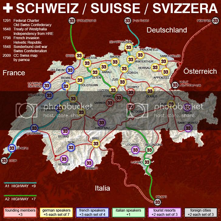
I really like the above map of Schweiz/Suisse/Svizzera (except perhaps for the blood red background). It took me a while but I found the original thread and scanned through the comments. All the graphics are defunct, so it was a bit hard to follow but it seems there were lots of constructive comments. The map-maker, Pamoa, hasn't logged on in four years, so I'm guessing I could steal his ideas and get the benefit of all those comments.
Switzerland is an interesting country for many reasons. Pamoa took advantage of several: three languages, tourist resorts, and history. Two comments that were made on the old thread caught my particular attention. One was that it would be VERY hard to capture either entire highway. I have found this to be the case on several maps that feature highways. I recently played a game of USA Rockies; it has three highways, all quite a bit shorter than these, and none were ever captured, not even on the last turns. Another comment, meant in jest, was that one theme that had been ignored was banks. Switzerland is famous for its banking system and several cities have major banking facilities. If I were to rip off the above map I think I'd forget about the "Founding Members" bonus and create one for holding all or most banking cities. Switzerland is way more famous for its banks than for what occurred in 1291.
But though I'm not above stealing some ideas, I'm not at all crazy about substantially re-doing someone else's work. As I said elsewhere, making these maps is a creative outlet for me. Whatever comes from someone else's creativity erodes my own motivation. Besides, no way could I put that many coats of arms on a map like Pamoa's and those COAs are more or less the main attraction of this thread. So... what I've come up with so far is shown below. I selected cities and resorts based on their fame and location. The COAs are placed rather accurately. I chose to go with tert and region boundaries because they afford better opportunity to make good use of my (if I say so myself) very attractive mountain chains as impassables. I'm starting with the small map (what you see is 561x370) because I'm getting really paranoid about downsizing; easier by far to upsize. The red lines are the mountain chains, the A's indicate the two airports at Geneva and Zurich, and the rest is obvious. Needless to say, this is just a mock-up meant to elicit feedback regarding the overall concept.

There are 20 terts. That would make this tied for the third smallest map with "Egypt: Lower". The two smaller ones, "Doodle Earth" and "Luxembourg" are both
extremely popular.
Remember that I will need room to provide a key that associates COAs with names and informs about regional bonuses. So even this small map will have to expand quite a bit (probably downward).
The terts:
Glarus
Altdorf
Davos
St. Moritz
Locarno
Lugano
Scuol
Simplon
Gstaad
Interlaken
St. Gallen
Verbier
Montreux
Fribourg
Geneva
Lucerne
Zurich
Basel
Bern
Neufchatel
A few were chosen simply because they have COAs and are located in what would otherwise be empty spaces because nothing more famous is nearby. Chances are I'm roughly as well-informed about Switzerland as the average CCer. Maybe a bit more. To me, 13 of the 20 terts are very recognizable/famous names. I'd never heard of Scoul (fountain COA on very far eastern edge) for instance, but I studied a very detailed map and could find nothing more famous over there. Because I can, in general, place COAs very close to actual city locations, I prefer to sacrifice recognizability on a few names than overall geographic accuracy.
As you can see from the base map, I'm also able to place mountains in a logical chain. The fact is, most of the southern half of the country is very mountainous. Lots of choices for us. But by creating a long chain interrupted by a few passes (should I add one on the far eastern edge so that bonus region of just two terts isn't so isolated?) I think I create an appropriate look and feel. I can add some clumps of mountains elsewhere that don't form effective impassables so that the geographic inaccuracy of a single chain is ameliorated.
What say y'all? Should I proceed on this basis?


