Mapmaker: MrBenn
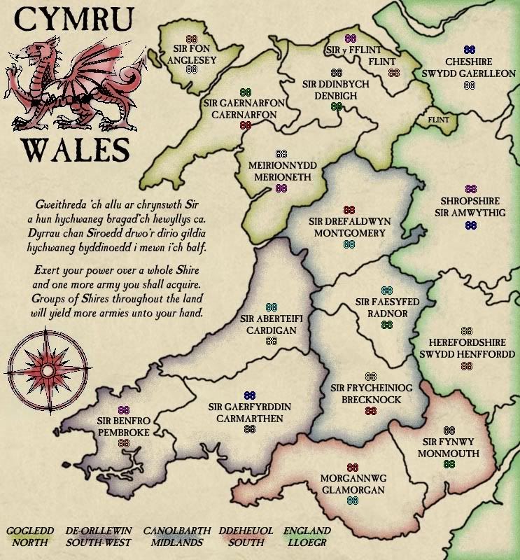
Territory Count: 48 (32 starting)
Bonuses: 5 Regions & 16 Triples
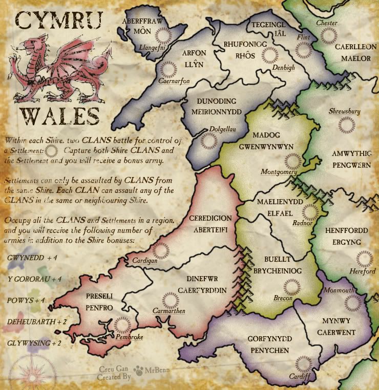
Gameplay: Almost standard, except two/three armies occupy each Shire area.
Size: Large 740px × 760px; Small 565px × 580px
Foundry Stamps:


Version 23/24 - 11 February 2009
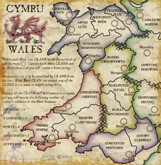
- Here is my absolutely final update (I hope)... There are no changes to the small map, but I have made some minor tweaks on the large one... all the army numbers are exactly the same distance (3px) from the territory name. I've redrawn a tiny bit of border by the Ial number, and shifted those names to get it to fit properly.
Here's the XML with the adjusted coordinates: http://www.fileden.com/files/2009/1/9/2 ... XML_05.xml
Here is the small image: http://i275.photobucket.com/albums/jj32 ... les23S.jpg
Here is the large image: http://i275.photobucket.com/albums/jj32 ... les24L.jpg
Here are all the test images:
- Small Map:http://i275.photobucket.com/albums/jj320/bpawley/Wales/Wales23S.jpg
Small Map 88 Test: http://i275.photobucket.com/albums/jj320/bpawley/Wales/Wales23S-88.jpg
Small Map 888 Test: http://i275.photobucket.com/albums/jj320/bpawley/Wales/Wales23S-888.jpg
Large Map:http://i275.photobucket.com/albums/jj320/bpawley/Wales/Wales24L.jpg
Large Map 88 Test: http://i275.photobucket.com/albums/jj320/bpawley/Wales/Wales24L-88.jpg
Large Map 888 Test: http://i275.photobucket.com/albums/jj320/bpawley/Wales/Wales24L-888.jpg
Version 23 - 3rd February 2009
Small Map
Large Map
XML: http://www.fileden.com/files/2009/1/9/2 ... XML_03.xml
- Conquer Club Map Maker
Test XML for Errors
- xml is valid. see test results.
Summary: 0 errors and 0 warnings detected in WalesXML_03.xml (21 continents, 48 territories)
Small Map:http://i275.photobucket.com/albums/jj320/bpawley/Wales/Wales23S.jpg
Small Map 88 Test: http://i275.photobucket.com/albums/jj320/bpawley/Wales/Wales23S-88.jpg
Small Map 888 Test: http://i275.photobucket.com/albums/jj320/bpawley/Wales/Wales23S-888.jpg
Large Map:http://i275.photobucket.com/albums/jj320/bpawley/Wales/Wales23L.jpg
Large Map 88 Test: http://i275.photobucket.com/albums/jj320/bpawley/Wales/Wales23L-88.jpg
Large Map 888 Test: http://i275.photobucket.com/albums/jj320/bpawley/Wales/Wales23L-888.jpg
Version 22 - 9th January 2009
- I have made good use of WM's XML generating spreadsheet, and knocked out the XML; and I've worked out a better way of using the Map Assistant to plot coordinates - and not a single one is out of place after the first attempt... Woohoo!!
The XML lists 21 continents - 16 for the shires, and then 5 for the regions proper.
I've changed the settlement circles on the small map so that the army numbers will centre properly.
The circumflex has been added to the couple of names that needed them - although I now need to update these territory names in the XML
Conquer Club Map Maker
XML: http://www.fileden.com/files/2009/1/9/2 ... XML_02.xml
Test XML for Errors
- xml is valid. see test results.
Summary: 0 errors and 0 warnings detected in WalesXML_02.xml (21 continents, 48 territories)
Small Map:http://i275.photobucket.com/albums/jj320/bpawley/Wales/Wales22S.jpg
Small Map 88 Test: http://i275.photobucket.com/albums/jj320/bpawley/Wales/Wales22S-88.jpg
Small Map 888 Test: http://i275.photobucket.com/albums/jj320/bpawley/Wales/Wales22S-888.jpg
Large Map:http://i275.photobucket.com/albums/jj320/bpawley/Wales/Wales22L.jpg
Large Map 88 Test: http://i275.photobucket.com/albums/jj320/bpawley/Wales/Wales22L-88.jpg
Large Map 888 Test: http://i275.photobucket.com/albums/jj320/bpawley/Wales/Wales22L-888.jpg
Version 21 - 7th January 2009
Small Map
Large Map
- I have increased the colour saturation of the blobs (official name) on the bonus legend.
The bonus values for the regions have been updated - the total bonus will include +1 for each shire
Hopefully the legend text is now fully comprehensible... the settlement icon has been moved into the first paragraph of instruction and looks a lot more coherent
Version 20 - 29th December 2008
Small Map
Large Map
- I've tweaked some of the background effects - turned them down slightly more on the small map than the large.
On the small map, the labels on the Isle of Anglesey have been moved/shrunk a bit to make it more obvious where the army numbers go
The Settlement image has reappeared on the legend.
Version 19 - 28th December 2008
Small Map
Large Map
- The biggest change is that of the instructive text - hopefully it is now much clearer how bonuses/attacks work
I have also moved the mountain range between green/blue to make the Northern region slightly harder to hold - this is the only thing about the gameplay that bugged me.
Since the addition of the settlements, I have increased the map sizes, and ensured that both versions now fit within the size restrictions.
Version 18 - 12th December 2008
Large Map
- I've added a small space between the two labels in each Shire to aid clarity
Version 17 - 10th December 2008
Large Map
- The map has been cropped a lot more tightly to the Welsh coastline, making the map slightly shorter.
The region bonuses have been moved to the side, and the wording of the explanatory text has been tweaked again.
I've shifted my signature slightly, and the compass has been moved and shrunk in order to accommodate the relocated legend.
I've added in some more mountains between Herefordshire and Shropshire to tidy up the border there, which looked a little odd with the tiny bit of neither county betwixt the two.
The typeface I'm using doesn't have an extended character set, so accented characters will be harder to add than I thought.
Aberffraw and Mon will probably remain the way they are, in order to make the labels best fit the space of the island.
In addition to these significant amendments, there have been a number of tweaks to shades of things, too numerous and petty to mention.
Version 16 - 30th November 2008
Large Map
- This image is at the size I've previously been using as my large, but since I've added the settlements, I'm contemplating using this size as the small...
I have tweaked some of the wording of the explanatory text, and made it slightly larger.
The settlements will all start with 3 neutrals, and can only be attacked by the clans in the same shire...I'm considering making it so they can't attack them back...
Points for discussion - relative merits of 3 territories per shire, and whether the settlements should be able to attack?
Version 15 - 15th November 2008
Large Map
- Here's an attempt at a version with the altered gameplay, as recently suggested. I really like the way it works, and it does give additional options to make a better game...
I have switched to the Welsh labels as suggested by Genghis Khant, and have used the County towns as the settlements. I've been a bit inconsistent with the use of English/Welsh names for the settlements, so will amend them at some point in the future - but at least they're more-or-less in the right place geographically!
My working image is bigger than the small and large images, so the settlement circles will need to be redrawn at the correct size in a future update. It's worth noting here that the settlements will all start neutral, which will negate the need for complex start-positions.
Version 14 - 8th November 2008
Small Map
Large Map
- All I've done is make the Cardiganshire / Montgomeryshire /Merioneth border a bit clearer, and moved some neutrals around.
I had been contemplating starting one of Anglesey neutral anyway - and it has the added bonus of having an equal distribution of players per region.
Second thing... bonuses...
I haven't updated the region bonuses since I've added in the mountains... I've run the numbers in to one of the bonus spreadsheets... (clicky) (The Shire Pairs are taken into consideration in column M)
I think some of the figures are a bit out, as the region size isn't that much of a factor...
Would it be acceptable to set the region bonus at double the number of Shires? ie North+5; SWest+3; Midlands+3;South+2; English+3? That make North a bit too high.... hmmm....
Any and all thoughts welcome
Version 13 - 7th November 2008
Large Map
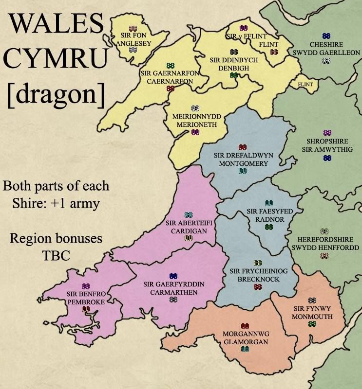
- Right... here is my first attempt at starting positions... rather than listing them, I've opted to display them using army placement, which is more visually impactive than an XML extract...
In 2 player games, each player will get a complete set of one colour. 6 territories from the unassigned colour will be shared between the two players, with the remaining territories starting neutral. It is possible for each player to receive a maximum of 3 shire pairs from the drop, but nobody will receive a bonus region from the drop. I think I've caluclated that there is 26.5% of dropping at least one shire pair, 7.5% of getting at least 2, and 3.75% of getting 3 pairs... dramatically lower than the list of probabilities I posted above. (I'm deliberately not posting my working out because I expect I've got it hopefully wrong)
In 3 player games, the armies will be divided up so that each player will get a complete set of one colour. Nobody will start with a shire pair or a region bonus.
4+ player games will be distributed totally randomly, and the starting positions will not be taken into consideration.
Version 12 - 23rd October 2008
Small Map
Large Map
- I've added some grunge to the rest of the text on the map
The region names on the English bonus blob been switched so that the Welsh translation is on the top
The bonus blobs for Midlands and South-West have been redone so they look more like the regions on the map.
Version 11 - 22nd October 2008
Small Map
Large Map
- The biggest change is the text - I've gone for Oaktowns poetry, which was marginally superior to mine, although I did have to correct some of the American spellings (neighbor)
I've shifted the colours where the mountains meet... Each mountain is now one colour or the other - I tried an attempt with no colour on them, but it just looked wrong, This version looks tidier than the previous one, which is what I was hoping to achieve.
The text has been mildly grunged, and I've changed the colour to a very dark brown instead of black.
To reiterate how the gameplay is supposed to work; each Shire has two armies. Hold both armies in a Shire for +1. The South-West (red) has 3 Shires, or 6 armies. If you hold this region, you will get (3 x +1) for each Shire, and (1 x +3) for holding the region.
Version 10 - 22nd Sept 2008
Small Map
Large Map
- The burn mark has been the subject of a lot of angst, and has accordingly made a swift departure.
The dark blue blob behind "Gogledd North 3" has been made a bit lighter. It still looks blue enough, but the text should be more visible now (at least that's the hope). I also made the green blob a bit more green.
I have added a Shire suffix to some territory names to help make the interpretation of the poetry a little easier...
Version 9 - 21st Sept 2008
Small Map
Large Map
- I have taken out the 'fold' across the middle as I wasn't really that keen on it.
The colours have been swapped around, and I've made the band of colour thicker to make it easier to distinguish. I think the colours are better placed now, but am tempted to rethink the thickness...
The large image has been made a bit smaller (even if only to appease RJ!)
I've also added a burn-mark. The hole is very slightly off-white, to match the colour of the background on the play-a-game screen.
I have changed the shapes of the region bonuses, picking out a shape from the corresponding region area instead of the previous blobs!
To clarify some of the gameplay issues, there are two territories (clans) in each geographical area(Shire). You get a +1 bonus for holding both territories/clans in each area/shire. The Shires are grouped into regions, which will yield an additional bonus. I have attempted to explain this through the medium of poetry, so some of the finesse may be lost?? In any case, the gameplay will be standard (ie no bombards/one-ways etc), except for the multiple armies per territory...
Version 8
- It's been a little while, but here is my first attempt at a grunged-up version...
I've taken a picture of some scrumpled of paper and added that to the background as a feint texture
There is a bit of 'weathering' to the edges, but I've also sprinkled some over the map at random
I'm not wholly convinced by the fold I've put across the middle, but I'll see what others think.
After much playing around, I have learnt a bit about custom brushes and drawn some mountains I am happy with. I'm using PS6, which doesn't have a 'jitter' feature, but I think they look good regardless.
I haven't swapped the colours around as I flattened the colours layer, and will need to see if I can get an untangled copy from an early version

Version 7
- Unpublished attempts at trying to draw mountains...
Version 6
Large and Small Images
Large Map
Small Map
- I've done a little tweaking, and put together a slightly smaller large image, and a smaller small image...
The sea now has a slight edge to it - there was a suggestion to have a blue tinge, but it didn't look right. I've opted for a slightly murky sea, which seems to fit the style of the map!
I've added the Shire suffix to some of the English territory names where they'll fit, which will hopefully make it slightly more obvious what the poem means when it talks about shires
There are now working small/large images - Gameplay discussion is desperately needed
Version 5
- Unpublished attempts at trying to do something fancy with the sea...
Version 4 (22/08/2008)
- I've added in some pale contour lines to help indicate the reason for the wonky compass. The compass has been faded into the background a bit more so it doesn't jump out so much. I've tried to smooth the dragon outline a little too...
I've updated the 'poetic' text to include the attack rule - how is it for clarity?
The overlapping army numbers have been nudged around a bit, and I've tweaked a border
On the subject of border-tweaking, I've amended the Flint border to get rid of the exclave
I've run the region bonusses through a calculator and taken off the amount you'd get for holding the Shire pairs. The English area should really be a +5, but I've upped it to a 6 to add to the confusion in foggy games
Oh, I've also adjusted the Cardigan/Montgomery/Merioneth border to make it clearer.
Version 3
- I've added the Dragon image, and I've drawn in a compass to match.
The font has been updated to one that looks suitably mappy... I like it
The slightly patchy region fills are gone, to be replaced with the edge-effect.
I've added the region names to the bottom of the map, ready to be populated with the region bonuses when they're decided
I've come up with some (cough) poetry (cough), and spent a lot of time playing around with online Welsh translators... If anybody here speaks Welsh, please let me know if it reads OK!
Version 2
- Here's a slightly more 'mappy' version - I've added on some army numbers to give a feel for how the gameplay will work... I thought it would make sense to have a +1 bonus for each county/shire, so have added that too...
Version 1
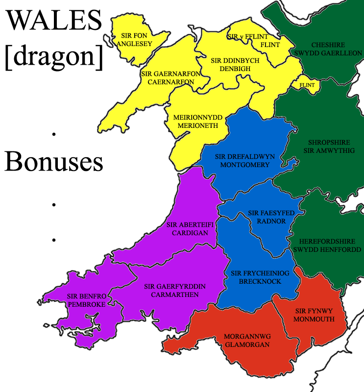
- Welsh geography is a bit messed up, and there have been several boundary changes to their counties over the past few years, and it looks probable that the administrative areas will continue to be shuffled around indefinitely. There are currently 8 administrative counties/regions in Wales, which is not enough for a CC map (unless you're a Doodle Assassin fan). So instead of using current boundaries, I have opted to use the 13 historic counties of Wales - these are the most consistently defined areas, and apparently have a 'resonance with which Welsh people can identify' (I read that somewhere!). To bump the territory count up, I've included the three English counties on the Wales/England border, some of which have bits which are almost Welsh in any case....
So, 16 counties in total - the bare minimum required for a map. Personally, I think that 16 terrs is still too small, so I had the idea to have two 'territories' per county based on the English/Welsh names for the counties, which makes 32 terrs, and an ideal sized map.

