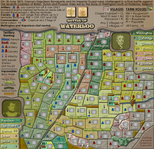
http://i155.photobucket.com/albums/s282 ... o_V30S.png
http://i155.photobucket.com/albums/s282 ... o_V30L.png
tnb80, coould you forward for update please.
Moderator: Cartographers


thenobodies80 wrote:Sent!


cairnswk wrote:Hopefully, that will keep some happy!


WILLIAMS5232 wrote:cairnswk wrote:Hopefully, that will keep some happy!
OK, but now the large map size seems to throw off the tert. locations. everything seems fine on small size. but large is way out of proportion and unplayable.
anyway. i like the map. so thanks for making it.
here is a screenshot


ManBungalow wrote:Hi Cairns, you've got a wonderful map here, as ever (perhaps even your best to date).
I've just one thing to mention today:
Some random fuzziness in the legend. It doesn't seem to be a problem for most, but I thought you might be willing to take a look at it.
...
I see this across all of that legend board, and the rest of the map seems very crisp.
Maybe it would just be a case of redoing the text?
This particularly on the small version.


agentcom wrote:I was bringing this up in another thread, but this is another map that has an ambiguous key. Particularly, there is no way of determining from the key which farm houses can be bombarded and if so from where


ManBungalow wrote:Actually, just looking at the map image on the first page of this thread (following on from my previous post in this thread), it seems that this is another map which suffers from file compression (like Rail Europe).
@nobodies,
whatever you did for Rail Europe, would it be possible to do for Waterloo?


ManBungalow wrote:ManBungalow wrote:Actually, just looking at the map image on the first page of this thread (following on from my previous post in this thread), it seems that this is another map which suffers from file compression (like Rail Europe).
@nobodies,
whatever you did for Rail Europe, would it be possible to do for Waterloo?
I will reiterate this as well.
Open the following 2 links in different tabs and compare them:
Available map image:
http://i155.photobucket.com/albums/s282 ... o_V30S.png
Currently used map image:
http://maps.conquerclub.com/Waterloo2.S.jpg
The former is much nicer in every way.


ManBungalow wrote:agentcom wrote:I was bringing this up in another thread, but this is another map that has an ambiguous key. Particularly, there is no way of determining from the key which farm houses can be bombarded and if so from where
I think it's okay. The farm houses which can be bombarded have a red infantry peg in them, and the part of the legend about artillery explains that blue artillery can bombard red infantry on the same side of the road.


thenobodies80 wrote:If cairnswk is ok with it, i'm ok with it.
It will be done this evening, as soon as I'm back home.


cairnswk wrote:thenobodies80 wrote:If cairnswk is ok with it, i'm ok with it.
It will be done this evening, as soon as I'm back home.
What are you going to do this evening??


thenobodies80 wrote:cairnswk wrote:thenobodies80 wrote:If cairnswk is ok with it, i'm ok with it.
It will be done this evening, as soon as I'm back home.
What are you going to do this evening??
Replace the current images with images of better quality, like what I did with your Rail map.


Users browsing this forum: No registered users