koontz1973 wrote:Shape, double posts are a no no. Please put everything into one post. As for being a fan of neutrals, I am with you their but they are needed. How can you not be a fan when you only have 1 game finished.
3 games
-Shape
Moderator: Cartographers
![]() by Shape on Sun Mar 17, 2013 9:27 pm
by Shape on Sun Mar 17, 2013 9:27 pm
koontz1973 wrote:Shape, double posts are a no no. Please put everything into one post. As for being a fan of neutrals, I am with you their but they are needed. How can you not be a fan when you only have 1 game finished.

![]() by koontz1973 on Sun Mar 17, 2013 11:50 pm
by koontz1973 on Sun Mar 17, 2013 11:50 pm
Shape wrote:Those black troops were the bane of my existence every game,


![]() by ManBungalow on Tue Mar 19, 2013 12:47 pm
by ManBungalow on Tue Mar 19, 2013 12:47 pm


![]() by Seamus76 on Wed Mar 20, 2013 12:14 am
by Seamus76 on Wed Mar 20, 2013 12:14 am
I think that will look pretty good actually. Thanks for the suggestion.ManBungalow wrote:Quick graphics suggestion:
The contours you have around the land in the sea (the bits which look like waves breaking on the beach): you could try having them in order of decreasing opacity, the make them blend into the sea like a gradient.
ie. the one nearest the coast have at 80% opacity, the next at 60% etc.
See how it looks.
Yeah, those arrows aren't working, they're antique clock hands, but I'll have something different for the next update. Just trying to get those Three Kingdom mountains all worked out at the moment, but will have an update this week.ManBungalow wrote:Also, the symbol you've used for one-way attack doesn't actually indicate which direction it's going in like an arrow does.


![]() by Seamus76 on Mon Apr 08, 2013 11:29 am
by Seamus76 on Mon Apr 08, 2013 11:29 am
![]() by Seamus76 on Mon Apr 08, 2013 11:13 pm
by Seamus76 on Mon Apr 08, 2013 11:13 pm
Thanks so much. Any feedback is greatly appreciated.Kschame1 wrote:I love this one!
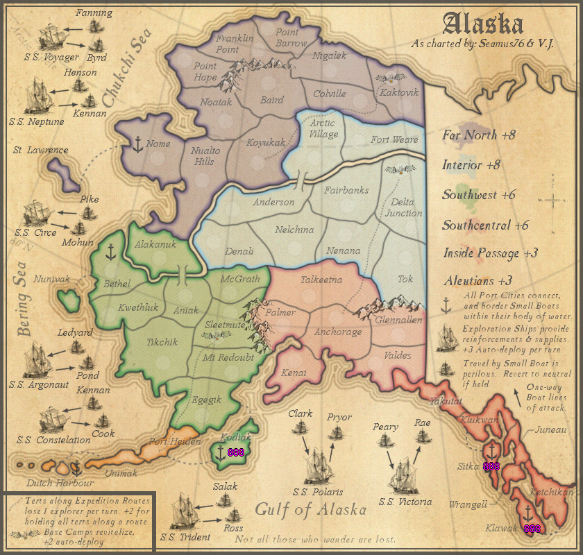
Seamus76 wrote:I'll be posting an update for this in the next day or two, which will include small boat names, we're there any other thoughts?
koontz1973 wrote:None from me for now.
![]() by Seamus76 on Tue Apr 09, 2013 11:34 am
by Seamus76 on Tue Apr 09, 2013 11:34 am

![]() by Seamus76 on Fri Apr 12, 2013 11:35 pm
by Seamus76 on Fri Apr 12, 2013 11:35 pm
![]() by thenobodies80 on Sat Apr 13, 2013 6:03 am
by thenobodies80 on Sat Apr 13, 2013 6:03 am


![]() by Seamus76 on Sat Apr 13, 2013 11:26 am
by Seamus76 on Sat Apr 13, 2013 11:26 am
thenobodies80 wrote:There's some good stuff here, enough to move this one forward imo.
I think Aleutian Islands are a bit overpowered...I understand there's a the decay for the expedition route, but the position let me think that is the best place to start.
I don't like so much the fact that the Southwest islands can't be reached using the very same bonus regions; that bonus region looks very hard to grab and hold imo.
Apart the above thoughts, if no one has additional input for this map project I will move it within the next 48 hours.
Nobodies
![]() by Seamus76 on Tue Apr 16, 2013 8:07 pm
by Seamus76 on Tue Apr 16, 2013 8:07 pm
Seamus76 wrote:thenobodies80 wrote:There's some good stuff here, enough to move this one forward imo.
I think Aleutian Islands are a bit overpowered...I understand there's a the decay for the expedition route, but the position let me think that is the best place to start.
I don't like so much the fact that the Southwest islands can't be reached using the very same bonus regions; that bonus region looks very hard to grab and hold imo.
Apart the above thoughts, if no one has additional input for this map project I will move it within the next 48 hours.
Nobodies
Thanks TNB.
What would you suggest for the Aleutians? Also, keep in mind Dutch Harbor does border three of the ships, which will be auto deploying, so if someone really wanted to break a bonus it wouldn't be as hard as you're thinking, maybe? Not sure.
I understand about the islands, as there are islands for the Aleutians, and Inside Passage as well that do not connect. Those Islands I did put docks on so as to at least have them attackable from other areas, but I see what you mean. What would be your thoughts to fixing that? My only thought was to add sea routs back to their respective region, which isn't a big deal, but might need some major highlighting to stand out. As an example has anyone noticed the sea route from Klawak to Ketchikan in the very bottom right corner of the Inside Passage? It's kind of hard to see, and the others to be added will be so short they will be hard to see as well, with out some major highlighting or something else creative.
Maybe once it's moved to the main foundry there will be some good thoughts. Thanks again, and if anyone has anything to help just let me know.
![]() by Seamus76 on Sun Apr 21, 2013 7:42 am
by Seamus76 on Sun Apr 21, 2013 7:42 am
To quote my favorite band of all time, Pink Floyd, Is there anybody out there?Seamus76 wrote:Seamus76 wrote:thenobodies80 wrote:There's some good stuff here, enough to move this one forward imo.
I think Aleutian Islands are a bit overpowered...I understand there's a the decay for the expedition route, but the position let me think that is the best place to start.
I don't like so much the fact that the Southwest islands can't be reached using the very same bonus regions; that bonus region looks very hard to grab and hold imo.
Apart the above thoughts, if no one has additional input for this map project I will move it within the next 48 hours.
Nobodies
Thanks TNB.
What would you suggest for the Aleutians? Also, keep in mind Dutch Harbor does border three of the ships, which will be auto deploying, so if someone really wanted to break a bonus it wouldn't be as hard as you're thinking, maybe? Not sure.
I understand about the islands, as there are islands for the Aleutians, and Inside Passage as well that do not connect. Those Islands I did put docks on so as to at least have them attackable from other areas, but I see what you mean. What would be your thoughts to fixing that? My only thought was to add sea routs back to their respective region, which isn't a big deal, but might need some major highlighting to stand out. As an example has anyone noticed the sea route from Klawak to Ketchikan in the very bottom right corner of the Inside Passage? It's kind of hard to see, and the others to be added will be so short they will be hard to see as well, with out some major highlighting or something else creative.
Maybe once it's moved to the main foundry there will be some good thoughts. Thanks again, and if anyone has anything to help just let me know.
TNB, just checking to see if you had any thoughts on this?
![]() by iAmCaffeine on Mon Apr 22, 2013 9:56 am
by iAmCaffeine on Mon Apr 22, 2013 9:56 am


![]() by Seamus76 on Mon Apr 22, 2013 10:07 am
by Seamus76 on Mon Apr 22, 2013 10:07 am
All comments are welcome at any stage, so let'm rip.iAmCaffeine wrote:Okay, I have some thoughts on this map but I understand there are different stages for gameplay, graphics and suchlike - so what stage are we at? Just want to make sure my comments are relevant.
![]() by iAmCaffeine on Mon Apr 22, 2013 10:45 am
by iAmCaffeine on Mon Apr 22, 2013 10:45 am
Seamus76 wrote:All comments are welcome at any stage, so let'm rip.iAmCaffeine wrote:Okay, I have some thoughts on this map but I understand there are different stages for gameplay, graphics and suchlike - so what stage are we at? Just want to make sure my comments are relevant.Some people are more into graphics, some more into gameplay, etc. I'll take whatever feedback I can get on this one, but technically it's still a "Draft", with Gameplay next, then Graphics, but again you can post whatever feedback you'd like, it's all helpful and appreciated.
I guess for me, Gameplay would be where I'd like the most feedback at this time, as I really like the Graphics for the most part.
![]() by Seamus76 on Tue Apr 23, 2013 11:09 am
by Seamus76 on Tue Apr 23, 2013 11:09 am
I see what you mean for the sharpness, and the next update will make all of the text soft like Colville. Also, you're right about the names that cross the borders, which I've been working to fix, and the next update should fix that as well. So, once that's posted I'd love you're thoughts again.iAmCaffeine wrote:Cool. I quite like the graphics as well, but the ports could be more obvious and I don't really like the text for the territories. It works well with the purple but everywhere else I think it looks too sharp. There are parts where it is fainter like Colville compared to Nigalek. Finally, it's very hard to read in some of the red and orange regions because of the borders.
You're right on this again. If you check the last update info in the OP you'll see that's one of the major GP issues I'd like to address. As you stated, those are the three Seas, and right now I think it could be more clear as well, but what would be some thoughts as to fixing that, anyone? I could use some kind of texture for each one, a different color for each maybe variations on light blue (this is my least favorite, as I'd like to keep the color to the land, and not use anything for the waters). Other thoughts?iAmCaffeine wrote:Now in terms of gameplay, I'm assuming the Gulf of Alaska, Bering Sea and Chukchi Sea are separate bodies of water, based on the placing of the names? I find that quite confusing as when you explain the Small Boats in their bodies of water, I'm not entirely sure where the bodies of water start and end, apart from the Gulf of Alaska. I can work it out from common sense, but it should be made more obvious - and I could still be wrong.
I really don't have a preference either way, I think the +8 came from some of the CA's. This should be something we can confirm once this is Draft stamped and moved to the main foundry. HINT HINT!!iAmCaffeine wrote:Based on the number of borders that need defending, and comparing to other bonuses, I think Interior should only be +7.
Good question. The overall theme of the map is charting/exploration, and there are multiple parts that independently come together to support that theme. The main ones being the ships, which help provide reinforcements and supplies to the mainland. The other part are the exploration routes, which to your point do not technically start with a ship landing point, but again support the overall theme of exploration, and provide additional gameplay bonuses and strategies. Both of these also independently support the theme of traversing one of the harshest climates and terrains in the world, one, with the killer neutral small boats, two, the -1 per tert along the expedition routes. Lol, I'm not sure that helps at all, but I guess think of them independently together.iAmCaffeine wrote:Maybe I'm being stupid, but what exactly is the point of the Small Boats and Exploration Ships? Do the Ships form part of the Expedition Routes? If not I just don't see the point in them.
![]() by koontz1973 on Tue Apr 23, 2013 12:26 pm
by koontz1973 on Tue Apr 23, 2013 12:26 pm
![]() by isaiah40 on Tue Apr 23, 2013 1:08 pm
by isaiah40 on Tue Apr 23, 2013 1:08 pm
koontz1973 wrote:Seamus, get the update posted for me so I can start to look at the GP. *HINT* *HINT*


![]() by Seamus76 on Tue Apr 23, 2013 8:20 pm
by Seamus76 on Tue Apr 23, 2013 8:20 pm
I don't get it.isaiah40 wrote:koontz1973 wrote:Seamus, get the update posted for me so I can start to look at the GP. *HINT* *HINT*
Fixed!
![]() by Seamus76 on Tue Apr 23, 2013 11:15 pm
by Seamus76 on Tue Apr 23, 2013 11:15 pm
![]() by koontz1973 on Sat Apr 27, 2013 12:48 am
by koontz1973 on Sat Apr 27, 2013 12:48 am
![]() by Seamus76 on Tue Apr 30, 2013 12:03 pm
by Seamus76 on Tue Apr 30, 2013 12:03 pm
koontz1973 wrote:You need to split up the seas on the map. Which boat belongs to which sea?
![]() by koontz1973 on Wed May 01, 2013 12:03 am
by koontz1973 on Wed May 01, 2013 12:03 am
Users browsing this forum: No registered users
|
|||||||
| Conquer Club is not associated with RISK online in any way. Copyright © 2006-2025 by Big Wham LLC | |||||||