i like it how it is.. but i think he means Maryland not part of the Sherman bonus.. like it's own color n such. and for someone to drop the key cities they would have to be lucky....if that's what he was saying
if u have all of sherman with of course maryland.. do u get five men? four for sherman and one for maryland?
American Civil War [Quenched]
Moderator: Cartographers


![]() by Elijah S on Sat Dec 08, 2007 2:13 pm
by Elijah S on Sat Dec 08, 2007 2:13 pm
I think the bonuses work well as they are... as is the case with all boards, the luck of the drop is an element of gameplay.
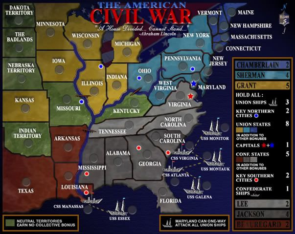
The key cities selected in the south were all sites of major battles, and those in the north were industrialized and contributed war materials to the Unon army. -The exception being Gettysburg which was, of course, a major battle site.
In selecting the key cities I also took into account how they would affect gameplay and tried to place them in a way which would make them somewhat equally attainable.
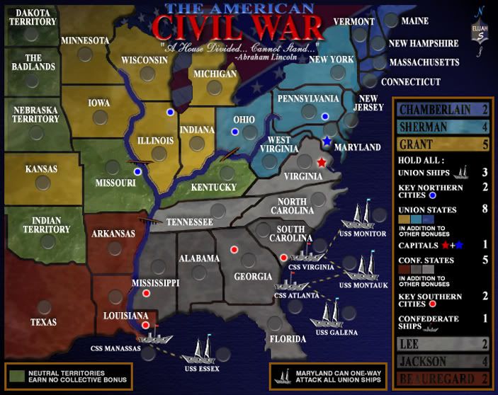
Since it looks like the blue-gray board is the favorite, I've been doing some touchups and fine-tuning to that map. -I also saw what Unit 2 was saying about there being a brighter blue near the Louisiana name, and that has been corrected.
Certain game elements (graphic and gameplay) are pretty much set at this point and I don't plan to redo the entire map.
A newer version of the blue-gray board will be posted within the next few days. -E
The key cities selected in the south were all sites of major battles, and those in the north were industrialized and contributed war materials to the Unon army. -The exception being Gettysburg which was, of course, a major battle site.
In selecting the key cities I also took into account how they would affect gameplay and tried to place them in a way which would make them somewhat equally attainable.
Since it looks like the blue-gray board is the favorite, I've been doing some touchups and fine-tuning to that map. -I also saw what Unit 2 was saying about there being a brighter blue near the Louisiana name, and that has been corrected.
Certain game elements (graphic and gameplay) are pretty much set at this point and I don't plan to redo the entire map.
A newer version of the blue-gray board will be posted within the next few days. -E
-
 Elijah S
- Posts: 672
- Joined: Wed May 09, 2007 6:24 pm


![]() by Elijah S on Sat Dec 08, 2007 8:46 pm
by Elijah S on Sat Dec 08, 2007 8:46 pm
Tisha wrote:i like it how it is.. but i think he means Maryland not part of the Sherman bonus.. like it's own color n such. and for someone to drop the key cities they would have to be lucky....if that's what he was saying
if u have all of sherman with of course maryland.. do u get five men? four for sherman and one for maryland?
Holding both capitals gets the +1 bonus.
Several earlier versions had Maryland as a Neutral State, but after some debate it was decided that the Union capital should fall in a Union state. So it was changed... and I think this is appropriate.
The Main Legend states "Hold All" above the bonus groupings and the icons beside "Capitals" has a red star "+" a blue star, so this should be pretty straightforward.
-
Elijah S
- Posts: 672
- Joined: Wed May 09, 2007 6:24 pm
![]() by trk1994 on Tue Dec 11, 2007 6:58 am
by trk1994 on Tue Dec 11, 2007 6:58 am
sorry, i didn't read all the other posts. but i think you should bump the bonuses for the southern territories. seems a little lopsided. lets give them equal chance and see who wins.
other wise, great map and great idea. i suggested it someone a while back and am very glad that someone who knows how has made the map. i wanna be the first to play!!!!!
other wise, great map and great idea. i suggested it someone a while back and am very glad that someone who knows how has made the map. i wanna be the first to play!!!!!
"We are advancing constantly and not interested in holding anything except the enemy. We're gonna hold 'em by the nose and we're gonna kick 'em in the ass!" -PATTON
-

trk1994
- Posts: 242
- Joined: Tue Jun 12, 2007 9:02 pm
- Location: South Texas


![]() by bryguy on Tue Dec 11, 2007 11:39 am
by bryguy on Tue Dec 11, 2007 11:39 am
ok, i like the map and all, but whats with the badlands being above the dakota territory? i went to the badlands for vacation this year and they were at the southern border of South Dakota, so i want to know why they are up so high??
-
bryguy
- Posts: 4381
- Joined: Tue Aug 07, 2007 8:50 am
- Location: Lost in a Jigsaw


![]() by Elijah S on Tue Dec 11, 2007 1:46 pm
by Elijah S on Tue Dec 11, 2007 1:46 pm
trk1994 wrote:sorry, i didn't read all the other posts. but i think you should bump the bonuses for the southern territories. seems a little lopsided. lets give them equal chance and see who wins.
other wise, great map and great idea. i suggested it someone a while back and am very glad that someone who knows how has made the map. i wanna be the first to play!!!!!
The bonus structure is based on a few things:
1) The fact that the South was comprised of fewer states.
2) The Union blockade effectively curtailed the South's ability to export its agriculture, critically wounding the South's economy
3) Board layout and gameplay.
While the bonuses for owning the entire Union is higher, there are several more states to acquire to get that bonus.
The same holds true for the "continent" bonuses.
This being a "historical" map, I tried to balance between historical accuracy and what would create the best gameplay action.
I also think the South has easier bonuses too and, as with most boards, we all know that the player who gains bonuses the quickest is usually in good contention... so I have to stick with the bonus structure as it is.
-
Elijah S
- Posts: 672
- Joined: Wed May 09, 2007 6:24 pm
![]() by Elijah S on Tue Dec 11, 2007 1:48 pm
by Elijah S on Tue Dec 11, 2007 1:48 pm
bryguy wrote:ok, i like the map and all, but whats with the badlands being above the dakota territory? i went to the badlands for vacation this year and they were at the southern border of South Dakota, so i want to know why they are up so high??
In earlier versions The Badlands was placed below the Dakota Territory... and I thought it was correct, but someone suggested switching them.
I will switch them back... easy fix!
Thanks... -Elijah
-
Elijah S
- Posts: 672
- Joined: Wed May 09, 2007 6:24 pm


![]() by bryguy on Tue Dec 11, 2007 2:17 pm
by bryguy on Tue Dec 11, 2007 2:17 pm
Elijah S wrote:bryguy wrote:ok, i like the map and all, but whats with the badlands being above the dakota territory? i went to the badlands for vacation this year and they were at the southern border of South Dakota, so i want to know why they are up so high??
In earlier versions The Badlands was placed below the Dakota Territory... and I thought it was correct, but someone suggested switching them.
I will switch them back... easy fix!
Thanks... -Elijah
thanks
-
bryguy
- Posts: 4381
- Joined: Tue Aug 07, 2007 8:50 am
- Location: Lost in a Jigsaw
![]() by spiesr on Tue Dec 11, 2007 5:11 pm
by spiesr on Tue Dec 11, 2007 5:11 pm
Actually they would not even be on this map, being in the western part of the state. ND should be badlands because it sucks...bryguy wrote:ok, i like the map and all, but whats with the badlands being above the dakota territory? i went to the badlands for vacation this year and they were at the southern border of South Dakota, so i want to know why they are up so high??
-

spiesr
- Posts: 2809
- Joined: Mon May 08, 2006 10:52 am
- Location: South Dakota


![]() by I GOT SERVED on Tue Dec 11, 2007 5:23 pm
by I GOT SERVED on Tue Dec 11, 2007 5:23 pm
Is there any way you can make the border between Kansas and Missouri less choppy/more smooth? Right now it doesn't look that great.

Highest score: 2512
Highest rank: 424
-

I GOT SERVED
- Posts: 1532
- Joined: Fri Jan 26, 2007 9:42 pm
- Location: Good 'ol New England


![]() by pepperonibread on Tue Dec 11, 2007 6:55 pm
by pepperonibread on Tue Dec 11, 2007 6:55 pm
I GOT SERVED wrote:Is there any way you can make the border between Kansas and Missouri less choppy/more smooth? Right now it doesn't look that great.
That border looks fine to me, but the Missouri-Wisconsin line looks a little too thick and pixelated. The river looks great now IMO, if it was just slightly blended into the ocean at its mouth, that would be perfect.

-

pepperonibread
- Posts: 954
- Joined: Sun Jan 28, 2007 4:33 pm
- Location: The Former Confederacy


![]() by AndrewB on Tue Dec 11, 2007 10:36 pm
by AndrewB on Tue Dec 11, 2007 10:36 pm
Good job, Elijah S!
But there are 3 concerns, which have not be addressed yet:
But there are 3 concerns, which have not be addressed yet:
AndrewB wrote:5. You should try to get rid of small text size in the legend too. If text does not fit, try to re-phrase it. I.E change "Union States in addition to other bonuses" to "Union States total" or "All Union States". Look into World 2.1 for examples.
13. Border in Kansas-Nebraska-Missouri corner does not represent the actual border line there. And as results looks quite "blocky", when in reality it is a river border.
14. The line which connects land masses to the water has different sharpness. For example compare left Michigan shoreline to its right shoreline. Same happens around Florida and some other places.

-

AndrewB
- Posts: 1814
- Joined: Mon Jun 12, 2006 5:02 pm
- Location: Edmonton, Canada, MST


Re: ...
![]() by Suzy1 on Wed Dec 12, 2007 2:20 pm
by Suzy1 on Wed Dec 12, 2007 2:20 pm
Coleman wrote:Sure, if you can show me flawless xml.Suzy1 wrote:I think this map is perfect and ready for play. Can I get a second from anyone to say it should be quenched?
I was referring to the look and the game play of the map. However, I have no doubt that Elijah will submit a perfectly flawless xml.
-
Suzy1
- Posts: 269
- Joined: Sat May 12, 2007 3:25 am


![]() by Elijah S on Wed Dec 12, 2007 5:03 pm
by Elijah S on Wed Dec 12, 2007 5:03 pm
To address some recent input-
I GOT SERVED - I don't see the issue with the border between Kansas and Missouri, but will take a look at it and see if there's anything that warrants fixing.
Pepperonibread - I'll also take a look at the border between Missouri and Wisconsin.
Spiesr - What you're referring to is called a bevel affect.
I like the bevel I have around the entire continent and think this is a matter of personal preference.
Andrew B- The legend is remaining the same. I think it's very uniform and legible and I don't plan to change it.
The border between Kansas, Nebraska and Missouri I will take a look at, but I'm not putting any more rivers in the map. -I think there's a balance between being geographically correct and creating good gameplay.
There are many rivers in that part of the country, but it would not enhance the game to try to place them in the map. -The Ohio and Mississippi are the most prominant in the region depicted and that's why I chose to put them there.
Regarding the difference in sharpness where the land touches the water, please read above, where I responded to spiesr.
As I stated previously, I'll make the minor changes that are warranted, but I can't make everyone happy...
Throughout the development of this board I've tried to remain open to all suggestions and feel that this map is very close to completion.
It's not my intention to be rude or appear unwilling to address valid issues, but some of the recent complaints seriously seem more like nitpicking than constructive criticism/advice.
I'm going to proceed with the xml and try to move this through the quenching process, rather than see it held up in the foundry for much longer.
-
Elijah S
- Posts: 672
- Joined: Wed May 09, 2007 6:24 pm
![]() by AndrewB on Wed Dec 12, 2007 10:19 pm
by AndrewB on Wed Dec 12, 2007 10:19 pm
Elijah S wrote:Spiesr - What you're referring to is called a bevel affect.
I like the bevel I have around the entire continent and think this is a matter of personal preference.
I like this bevel effect you have going, but it is NOT around entire continent. One side of Michigan lake has it, and other side does. It should be consistent throughout the whole continent.
Elijah S wrote:Andrew B- The legend is remaining the same. I think it's very uniform and legible and I don't plan to change it.
This is just plain stubbornness. And this is not addressing my concern. Why do you need to say: "in addition to other bonuses" when you can just say "extra" or "whole union state"?
I am not expert in the graphics, but such a small change will take max 10 mins from you. Try it, and you might like it yourself.
Also the font in the legend is not consistent:
Compare the 'E's in the "Lee". They look different. Also first 'A' in Beauregard is very light, almost gray color. All letters should be consistent size and color.
Elijah S wrote:The border between Kansas, Nebraska and Missouri I will take a look at, but I'm not putting any more rivers in the map. -I think there's a balance between being geographically correct and creating good gameplay.
There are many rivers in that part of the country, but it would not enhance the game to try to place them in the map. -The Ohio and Mississippi are the most prominant in the region depicted and that's why I chose to put them there.
Probably I didn't communicate my message well. I don't think you need a river there. And you should not re-arrange the borders for the gameplay. But you need to smoothen the border. It has those straight angles there. But it should be smooth, like West Virginia-Maryland-Virginia border.
Elijah S wrote:As I stated previously, I'll make the minor changes that are warranted, but I can't make everyone happy...
Throughout the development of this board I've tried to remain open to all suggestions and feel that this map is very close to completion.
It's not my intention to be rude or appear unwilling to address valid issues, but some of the recent complaints seriously seem more like nitpicking than constructive criticism/advice.
Elijah, during designing the map you can come across the issue, which you just don't want to fix, but it is not good enough explanation. Everyone here want to see your map at play, and we are just helping you to make this map better. It is not nitpicking.
-
AndrewB
- Posts: 1814
- Joined: Mon Jun 12, 2006 5:02 pm
- Location: Edmonton, Canada, MST
![]() by Elijah S on Thu Dec 13, 2007 11:56 am
by Elijah S on Thu Dec 13, 2007 11:56 am
I've done yet more changes to the map and the newest version will be up for everyone's "critique" probably later today or tomorrow.
Andrew B - To address each of your concerns...
-I'm not changing the legend or phrasing of it. It's pretty clear and was even put to a poll way back in this thread. I like it as it is.
-I've changed the height and angle of the continent bevel, although I really didn't see an issue with it as it was.
-The "E" in Lee IS in the same font style as the other General's names, but I did replace the "A" in Beauregard that was affected by the textured overlay in the legend.
-I looked into what you were saying about the border between Kansas, Nebraska and Missouri and have changed it to more closely reflect the actual border which, as you stated, is a river.
Regarding what you said about me not "wanting to make changes" or providing a "good enough explanation"...
Considering that I'm the one who has put the 100's of hours in this map and trying to address every complaint made about it, I think I'm entitled to have my own preferences. If my preferences happen to be different than yours it doesn't mean that I just don't want to take the time to change things. In fact, the majority of positive changes in this board have come from suggestions made by other members and I've been very receptive throughout this process.
I apologize for being kindof edgy, but a few people (not you Andrew) seem to think that I'm obligated to make every change they suggest.
Some even use demanding phrases like "change this" and "fix that" when they have no regard or genuine appreciation for the time involved in reworking the graphics.
Again, I'll be posting the newest version soon... -Elijah
-
Elijah S
- Posts: 672
- Joined: Wed May 09, 2007 6:24 pm
Who is online
Users browsing this forum: No registered users
|
|||||||
| Conquer Club is not associated with RISK online in any way. Copyright © 2006-2025 by Big Wham LLC | |||||||