Rock + History = Magic
This looks like a promising theme.
Moderator: Cartographers
![]() by Gillipig on Fri Jun 29, 2012 11:54 am
by Gillipig on Fri Jun 29, 2012 11:54 am


![]() by cairnswk on Fri Jun 29, 2012 2:46 pm
by cairnswk on Fri Jun 29, 2012 2:46 pm


![]() by cairnswk on Fri Jun 29, 2012 7:23 pm
by cairnswk on Fri Jun 29, 2012 7:23 pm
![]() by nolefan5311 on Sat Jul 07, 2012 8:38 pm
by nolefan5311 on Sat Jul 07, 2012 8:38 pm


![]() by cairnswk on Wed Jul 11, 2012 4:37 pm
by cairnswk on Wed Jul 11, 2012 4:37 pm
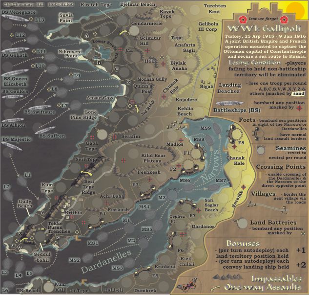
nolefan5311 wrote:For the Land Batteries...is the Kum Kali battery supposed to be able to bombard say, the A Landing Beach? If not, I think you need to indicate some sort of range attack for these.
Same for the battleships, but I assume you want any battleship to be able to bombard all the marked territories, no matter if it's on the other side of the map. Perhaps you should make these targets more distinguishable...change the actual color of the region or something? Since the battleships are so important, distinguishing the regions that they bombard a little more clearly would seem to jive with theme of the map. The targets tend to be a little confusing, especially with the map being so small.
Are the starting positions on the land associated with any particular battleship, or are they deployed completely randomly from the battleships you own? Nothing leads to me to believe they are associated, I was just curious.
Does Krithia village directly border Madios village? The legend indicates that villages border each other via the roads, but there is also an army circle sitting on the road in the Seri Tepe Ridge region which could lead to confusion.
The border between Kavak Tepe and Anafarta Sagir is hard to make out.
Do the Land Batteries also have normal land assault borders similar to the Forts? If not, I think it could be slightly disadvantageous having one of those as a starting position.
Have you thought about having M3 border more than just one MS ship? I'm not sure if you wanted a chokepoint directly after a killer neutral. Maybe just change the assault route to two assault routes: M3 > MS6 > MS8 and M3 > MS7 > MS9.
The Convoy Landing Ships mentioned in the legend, are those the "L" ships? I think some clarification needs to be made there.
I only count 14 starting positions on land (from north to south): Gendarmarie, Gelibolu III Corp, 3rd RIdge, Krithia, Feshkesh, F1, Saraijik, Sari Saglar Beach, Cephez Pt., Kizil-chilali, Erinkeul, Dumbrek, Kum Kali. I can't tell if Gaba Tepe is a starting position or not because it looks like there are two numbers there. If it is, that's still only 15. Doesn't seem consistent as each player in an 8 player game is going to be deployed one Battleship, it's associated L ship, and an L ship in the bottom of the map.
It's a +1 for each land territory position held, but it's also a -1 for each Landing Beach region. Maybe instead of saying that they lose one per round (which they won't, they will just maintain the troops that are already there), indicate they are not included in the Land Bonus or something?
What do you think?
![]() by cairnswk on Wed Jul 11, 2012 4:50 pm
by cairnswk on Wed Jul 11, 2012 4:50 pm
![]() by cairnswk on Mon Aug 06, 2012 7:06 pm
by cairnswk on Mon Aug 06, 2012 7:06 pm
![]() by sannemanrobinson on Tue Aug 07, 2012 3:47 am
by sannemanrobinson on Tue Aug 07, 2012 3:47 am


![]() by cairnswk on Tue Aug 07, 2012 3:42 pm
by cairnswk on Tue Aug 07, 2012 3:42 pm
sannemanrobinson wrote:...
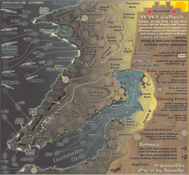
Is the Blue line between Bigale and Madios a road?
![]() by Oneyed on Fri Aug 10, 2012 2:21 am
by Oneyed on Fri Aug 10, 2012 2:21 am


![]() by cairnswk on Mon Aug 13, 2012 5:54 pm
by cairnswk on Mon Aug 13, 2012 5:54 pm
![]() by Oneyed on Mon Aug 13, 2012 6:10 pm
by Oneyed on Mon Aug 13, 2012 6:10 pm
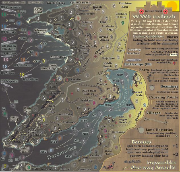
cairnswk wrote:MS are mine sweepers...
refer to Forts for the bombardments in the Dardenelles and Narrows
cairnswk wrote:L = landing craft
that's correct..the turks only had bombardment capabilities
![]() by cairnswk on Tue Aug 14, 2012 4:37 pm
by cairnswk on Tue Aug 14, 2012 4:37 pm
Oneyed wrote:cairnswk wrote:MS are mine sweepers...
refer to Forts for the bombardments in the Dardenelles and Narrows
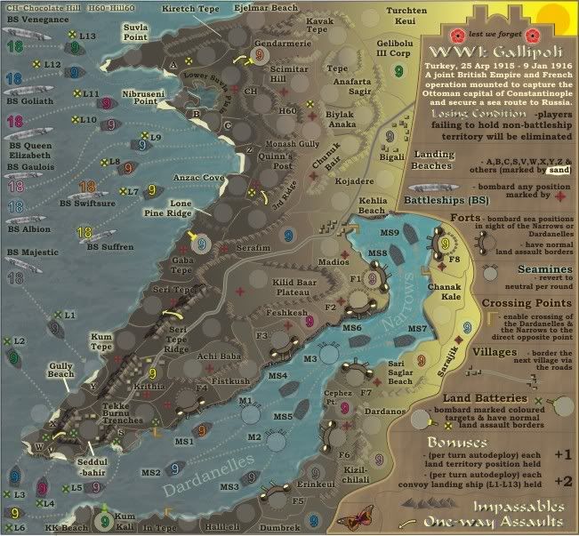
I can not see any way how to attack MS1, MS2, MS3.
Yes. L2-L6 will be starting positions.L = landing craft
that's correct..the turks only had bombardment capabilities
most of "L" is possible to attack from battle ships. but L2,L3, L4, L5, L6 is not possible to attack. when I read map correctly the battle ships will be starting positions. so also L2 - L6 will be starting positions?...
Oneyed
![]() by cairnswk on Tue Aug 14, 2012 4:46 pm
by cairnswk on Tue Aug 14, 2012 4:46 pm
cairnswk wrote:Oneyed wrote: could you change something on the road between Madios and Bigali? for me it also looks unclear that it is road.
the main problem is Kehlia Beach name which cover road junction between dark and light area.
Yes
border between Kojadere and Chunuk Bair is not clear. the borders on the junction betwen dark and light area are somewhere hard visible (Kavak Tepe, Gendarmarie, Tepe, Anafarta Sagir, Biylak Anaka, Monash Gully, Chunuk Bair).
yes they can be fixed
![]() by Oneyed on Wed Aug 15, 2012 1:50 am
by Oneyed on Wed Aug 15, 2012 1:50 am
cairnswk wrote:as such they are not assualtable...but you can bombard them (to neutral) from the forts
Yes. L2-L6 will be starting positions.
there are various combinations of starting positions which include battleships, landing craft, mine sweepers and land positions
pls note where the coloured numbers are for the starting positions.
cairnswk wrote:I have widened the road, changde the colour, and moved the name and army circle so that it is more visisble
pls refresh v21 above.
cairnswk wrote:You'll have to wait a bit for this one...uni calls...and these changes involve significant improvements to the mountains as borders in these regions so they can be made clearer for you
![]() by Robespierre__ on Sat Aug 25, 2012 10:25 am
by Robespierre__ on Sat Aug 25, 2012 10:25 am


![]() by nolefan5311 on Sat Sep 08, 2012 9:08 pm
by nolefan5311 on Sat Sep 08, 2012 9:08 pm
![]() by cairnswk on Fri Sep 14, 2012 8:01 pm
by cairnswk on Fri Sep 14, 2012 8:01 pm
![]() by nolefan5311 on Fri Sep 14, 2012 10:06 pm
by nolefan5311 on Fri Sep 14, 2012 10:06 pm
cairnswk wrote:^^^^ nolenfan5311...before i go changing lots of names which i got from mostly Australian Gallipoli sources....
could you please identify every one of your name sources so that i can determine their accuracy and whether i wish to use them or not
I will not use Wiki sources unless they are totally referenced.
Also some places you've indicated should be something else.
You should know by now that for the sake of making these maps, that totally accuracy will not be achieved.
If i have put a region in and called it something, it is because it is important to the campaign - from my point of view and the Australian theme of the map.
I am not saying i am unwilling to change names, but i want them to be well reliable and i would prefer to rely on war records if possible.
nolefan5311 wrote:That's all I've got for now, but that should keep you busy. I need to study a bit more closely the potential drop combinations and if there could be any potential issues. But just to clarify, the only drop associations are the battleship and its bordering L ship, right (as in, I won't be dropped Suffren, L7, L6, Krithia, and F8 every time, right? Those last three regions will be randomly distributed?)
![]() by iancanton on Sun Sep 23, 2012 2:52 am
by iancanton on Sun Sep 23, 2012 2:52 am


![]() by cairnswk on Wed Oct 03, 2012 3:13 pm
by cairnswk on Wed Oct 03, 2012 3:13 pm
iancanton wrote:unique among cc maps, this one is virtually unreadable for me because the colours in the opera browser are all reversed, with black text on dark blue land. any idea why this might be?
ian.
![]() by iancanton on Thu Oct 04, 2012 4:09 pm
by iancanton on Thu Oct 04, 2012 4:09 pm
![]() by Arama86n on Sun Nov 04, 2012 2:42 pm
by Arama86n on Sun Nov 04, 2012 2:42 pm


![]() by nolefan5311 on Fri Nov 16, 2012 6:27 pm
by nolefan5311 on Fri Nov 16, 2012 6:27 pm
![]() by cairnswk on Fri Nov 16, 2012 8:10 pm
by cairnswk on Fri Nov 16, 2012 8:10 pm
nolefan5311 wrote:As it appears development on this map has stalled (it has been several months since an update), this map is being Moved to the Recycling Bin for the time being. If the mapmaker wants to continue with the map, then one of the Foundry Moderators will be able to help put the thread back into the Foundry system, after an update has been made.
Users browsing this forum: No registered users
|
|||||||
| Conquer Club is not associated with RISK online in any way. Copyright © 2006-2025 by Big Wham LLC | |||||||