Page 6 of 16

Re: First Nations of North America.. UPDATE 05/15

PostPosted: Tue Jun 02, 2009 11:39 pm
by Tisha
JrFan88 wrote:Great map, love the theme. Wish I was half as talented. However, there are 2 glaring inaccuracies.

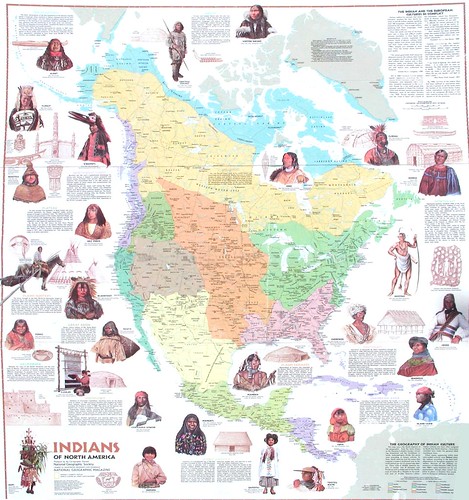
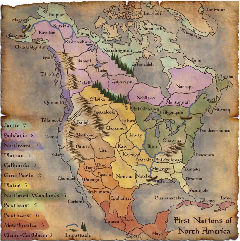
First: Where are the Cherokee? They should occupy the WHOLE territory you've given to the Yamasee, and at least the southern THIRD of what you have assigned to the Tuscarora.

Second: The entire territory you've given to the Nemene (whoever they are), or AT LEAST the southern 2/3, belonged to the Comanche; historically they controlled the largest hunting range of ANY plains nation - from New Mexico to Colorado and Kansas, all of Oklahoma and most of Texas.

I don't know who you relied on for research, but they were way off on both of these.

Sorry, but as a 1/4 blood Cherokee married to a mixed Apache/Comanche, I kinda have a thin skin about this sort of thing. Don't mean to bust yer balls, but it's kinda important to get this right.


Cherokee are there and Comanche are there.. just because I didn't use their names the Europeans gave them, doesn't mean they are missing. and just because they aren't exactly where you "know" they were in the 1600- 1700.. doesn't mean I have them completely wrong. The Cherokee migrated down from the north.. how do you know exactly where all the tribes were back then?

my glaring inaccuracies aren't and inaccurate as you think they are..

I am using the earliest names I can find for the tribes.. whether people recognize the names or not.

if I'm not so nice.. it's because some of the posts here are irritating.
someone says the impassables are too bold, then someone comes along and says make them bolder..
someone says the canoes stick out to much, someone else says the canoes blend in to much..
someone says the north is not holdable, so I try helping by adding not passable trees there, but of course there are no trees in the north (by the way, my trees are like a half inch above the boreal forest tree line, not much of a stretch there)

I like the regions the names they are. even if I change a name from southwest to sand or whatever, it's still not going to be a native name. Even if i change the name artic to Nunaat, the people down south didn't call the arctic Nunaat. I'm sure they had their own name for it.


I'm messing around with the trees and adding some great names that have been suggested. I'll have an update soon..

Re: First Nations of North America.. UPDATE 05/15

PostPosted: Wed Jun 03, 2009 1:39 am
by JrFan88
Cherokee IS NOT a European name, it's their OWN name for themselves, and they were in place in the southeast BEFORE the earliest Virginia colonies. European settlers were encountering them BEFORE the French and Indian wars. What name are you using? Comanche is not a European name either, it was given to them by the Utes, derived from a word meaning (closely anyway) "bad neighbors". They were in place by at least 1700. Again, what name are you using? These are historical facts. Forgive me if I take you to task on them, but they are a part of my direct ancestry and heritage. I do believe I know what I'm talking about. Please quote your sources regarding naming conventions and geographical history.

p.s: If you'd like, feel free to e-mail me on this subject. That may be a more suitable way to debate this particular point.

Re: First Nations of North America.. UPDATE 05/15

PostPosted: Wed Jun 03, 2009 1:24 pm
by AndyDufresne
tisha wrote:if I'm not so nice.. it's because some of the posts here are irritating.
someone says the impassables are too bold, then someone comes along and says make them bolder..
someone says the canoes stick out to much, someone else says the canoes blend in to much..
someone says the north is not holdable, so I try helping by adding not passable trees there, but of course there are no trees in the north (by the way, my trees are like a half inch above the boreal forest tree line, not much of a stretch there)


You just described a heart of the Foundry Process. Differing viewpoints! Just keep working on things and be open to discussion, and your map here will continue to thrive and turn out to be an excellent map, Tisha. :)


--Andy

Re: First Nations of North America.. UPDATE 05/15

PostPosted: Wed Jun 03, 2009 2:02 pm
by Industrial Helix
Absolutely beautiful map, I really love the colors and how it works with the theme. Nice work there.

Gripes:

The canoes don't really look like canoes to me, once i read it in the thread it seemed obvious that they were, but it didn't strike me at first sight. Maybe alter the graphic a little? Throw something in the key? Something to think about I guess.

As for the North and trees debate... I would assume that ice and distance would be the realistic key advantage in these areas, perhaps you could use that to your advantage.

I think what is now present day mexico is a littl etoo out there in the open... perhaps add in the Rio Grande or the Colorado Rivers to break it up some?

Anyway, best of luck working this map through. I think it looks really great so far.

Re: First Nations of North America.. UPDATE 05/15

PostPosted: Wed Jun 03, 2009 8:47 pm
by lostatlimbo
Tisha wrote: if I'm not so nice.. it's because some of the posts here are irritating.


Tisha - as Andy said, this is the nature of map-making. While I can empathize with your frustrations, you should be happy that there are so many people are interested and have opinions to share. This means your map has a lot of support to push it through the process - something my maps sorely lack.

My best advice to you is to not react to all of the advice as it comes. If you don't completely agree with a suggestion, let it simmer and be debated a little before making an update, but still be prepared to change it back or reinvent something. (my PSDs have many many layers of graphics i've done again and again)

For the record, I don't have a problem with the trees being up there. Sometimes you have to stretch reality to make a good map. I think it will work if they're alpine trees (though I also like IndustrialHelix's ice suggestion). I personally think the mountains look fantastic and the canoes look like canoes to me, but I think lightening them a shade or two would help your cause.

About your territory names - I understand what you are going for, but I also think you're fighting a losing battle. As there is no official "era" for this map, its going to be difficult to accurately place every tribe in the right place with the right name. The tribal spread and identifications changed a lot - its not as if they drew real boundaries. Tribes merged ,split, etc, over time. I appreciate your thirst for detail, but in the long run, people will expect to see the tribal names and places they recognize. Remember - this is a game map, not a research map.

$.02

Re: First Nations of North America.. UPDATE 05/15

PostPosted: Wed Jun 03, 2009 9:31 pm
by Bruceswar
Taken from this image .....

Image

A larger version of it

Re: First Nations of North America.. UPDATE 05/15

PostPosted: Thu Jun 04, 2009 2:57 pm
by JrFan88
Again, I love the idea and the theme. But I have to agree with a number of other posts: perhaps you're being a bit too ambitious. I applaud your attention to detail, but the map may be too detailed.

I'm no cartographer, and an even worse artist, but if I had done this map, I would have limited the scope to the lower 48; then divided that into basic geographic regions (Pacific NW, West and/or SW, Plains/Mid-west, etc.) then sub-divided those by nation, using (and I know you wanted to use pre-European names) well recognized tribal names. For example, a big chunk of the Northeast could have been taken up with just the Iroquois Confederation and been done with. You'd probably have wound up with about 25% fewer regions/territories - and about 50% fewer headaches.

But then again, that's just my opinion. I could be wrong, and often am. Just ask my wife. :lol:

Re: First Nations of North America.. UPDATE 05/15

PostPosted: Fri Jun 05, 2009 4:59 pm
by MrBenn
I still think this is one of the nicest looking maps in the foundry right now...

Something about the trees and the mountains don't look right together... have a look at some of these for inspiration (just focus on the trees):

http://toknowasiamknown.files.wordpress.com/2007/07/narnia-map.jpg
http://www.cartographersguild.com/feature/Dolmen.jpg
http://fc01.deviantart.com/fs28/f/2008/117/1/6/Athannar_Map_by_Atherenn.jpg

Re: First Nations of North America.. UPDATE 05/15

PostPosted: Sat Jun 06, 2009 1:31 pm
by grandin
This is by far the most beautiful map on CC. I absolutely love it! :)

This is the kind of map i like. Beautiful, lots of territories, and simple and straightforward gameplay. I haven't even dared to touch all the weird AOR/waterloo/whatever maps yet.

Sure, maybe pine-trees would be more appropriate that far up north... but it's not that important.

Here's a really good map that might be of use to you:
National Geographic, North American Indian Cultures


One small thing (and i know opinions differ, but still):
I'm having a really hard time trying to distinguish the border between Sub-Arctic and Plateau - even after looking at the map for some time. The colors are just way to similar.

I really don't think you should remove any territories - if anything, maybe the sub-arctic could somehow be split into to two separate bonus continents, if it is historically justifiable.

In any case, the map is breathtaking.

Re: First Nations of North America.. UPDATE 05/15

PostPosted: Thu Jun 11, 2009 5:12 am
by lt_oddball
I like the map.

Good to see the proper indian :D names on the map instead of the scientist's references.

The Canoo could be a bit improved (a small indian figure pedelling in the back :P ) and a bit lighter buff colour (it does resemble a dark brown bake-banana :| ).
But any unclarity is removed if you put a canoo in the legend and say "passable river".

The Rio Grande is not so "grand" (as in terms of impassability) and besides doesn't run across (W-E) America..so it wouldnot be a map improvement at all running S-N.

Who cares about the trees ? What is the alternative ? drawing cracked iceplateaus ? Or a line up of vicious Polarbears ??

For me, your map is almost there... :D

Re: First Nations of North America.. UPDATE 05/15

PostPosted: Thu Jun 11, 2009 12:19 pm
by Tisha
lt_oddball wrote:I like the map.

Good to see the proper indian :D names on the map instead of the scientist's references.

The Canoo could be a bit improved (a small indian figure pedelling in the back :P ) and a bit lighter buff colour (it does resemble a dark brown bake-banana :| ).
But any unclarity is removed if you put a canoo in the legend and say "passable river".

The Rio Grande is not so "grand" (as in terms of impassability) and besides doesn't run across (W-E) America..so it wouldnot be a map improvement at all running S-N.

Who cares about the trees ? What is the alternative ? drawing cracked iceplateaus ? Or a line up of vicious Polarbears ??

For me, your map is almost there... :D

Polarbears YES!!! :lol:

Re: First Nations of North America.. UPDATE 05/15

PostPosted: Thu Jun 11, 2009 3:35 pm
by Scott-Land
No kidding-- what's with all the fuss about ... where were these people when the foundry passed the 70+ other maps ?!

Quite possibly the best looking map the site has seen Tisha-- fantastic job !

Re: First Nations of North America.. UPDATE 05/15

PostPosted: Thu Jun 11, 2009 9:42 pm
by lostatlimbo
Scott-Land wrote:No kidding-- what's with all the fuss about ... where were these people when the foundry passed the 70+ other maps ?! Quite possibly the best looking map the site has seen Tisha-- fantastic job !


I don't think anyone has suggested that this is a bad map. Everyone has raved about it so far, but what's wrong with making the map the best it can be?

There weren't as many people on CC or in the Foundry when a lot of those other maps were made, which is precisely why so many of them are currently receiving makeovers or sequels in the foundry now.

Re: First Nations of North America.. UPDATE 05/15

PostPosted: Thu Jun 11, 2009 9:56 pm
by Scott-Land
lostatlimbo wrote:There weren't as many people on CC or in the Foundry when a lot of those other maps were made, which is precisely why so many of them are currently receiving makeovers or sequels in the foundry now.


Who was referring to back then-- certainly not I ?

From what I've read in this thread constructive criticism is one thing but when each poster/member contradicts the previous post-- it becomes a bit overbearing. This after all is a service that these mapmakers are giving to Lack for FREE. I'm merely suggesting to stop jerking her around in every direction, and not post a problem with the map without some forethought. Tisha's obviously frustrated and it should be a pleasant experience for her.

Re: First Nations of North America.. UPDATE 05/15

PostPosted: Fri Jun 12, 2009 12:23 pm
by AndyDufresne
I don't think anyone in intentionally trying to jerk anyone around---people just always have differing views when it comes to production and how it goes. :) In the end, everyone is working for the same goal: an awesome map. Sometimes we all forget that. ;)


--Andy

Re: First Nations of North America.. UPDATE 05/15

PostPosted: Thu Jun 18, 2009 12:34 am
by lostatlimbo
Scott-Land wrote:Tisha's obviously frustrated and it should be a pleasant experience for her.


Oh, I'm sorry. I thought it would be a map everyone could play on. If this is all just for one person's pleasure, then I'll keep my opinions to myself.

Re: First Nations of North America.. UPDATE 05/15

PostPosted: Sat Jun 20, 2009 12:56 pm
by karel
tisha love the map,great job :D
i can't wait to play it when i come back,keep up the good work :lol:

Re: First Nations of North America.. UPDATE 05/15

PostPosted: Sat Jun 20, 2009 4:29 pm
by targetman377
i know you said you where working on the trees but i kinda like it like that i love the graphics i think that this is one of the best maps that is coming!!!!!!

Re: First Nations of North America.. UPDATE 05/15

PostPosted: Sat Jun 20, 2009 6:35 pm
by lt_oddball
lostatlimbo wrote:
Scott-Land wrote:Tisha's obviously frustrated and it should be a pleasant experience for her.


Oh, I'm sorry. I thought it would be a map everyone could play on. If this is all just for one person's pleasure, then I'll keep my opinions to myself.


Likewise, comments and critique should only be made if it is in the interest of common play, and not solely to the nitpicking pleasure of one individual... :geek:

Re: First Nations of North America.. UPDATE 05/15

PostPosted: Sun Jun 21, 2009 8:09 pm
by Tisha
I changed some territories around, but haven't thought about bonuses yet.. :|
changed the trees too
lightened the canoes a tiny bit
Image

Re: First Nations of North America.. UPDATE 06/21, pg. 10

PostPosted: Mon Jun 22, 2009 12:25 am
by lgoasklucyl
While this is just going to create more turmoil for you, I personally loved the original trees =P

Map-makers on this site toil endlessly trying to create great-looking trees, and I was convinced that you had done so with the first set. Not only that, but you had done so in a way that perfectly suited the artistic styling of the rest of the map.

Just a shame to let them go to waste like that :oops:

Besides that, the map is looking gorgeous =)

Perfect color scheme, mountains, art, font, etc...

Now that I look closer, I guess the trees match the canoes (in the sense that they're slightly more 'realistic' looking), so I can see where people were coming from in that regard.

Now... hand drawn canoes in the same vein as the original trees.... O:)

lol.

Great work, can't wait to play it :)

Re: First Nations of North America.. UPDATE 05/15

PostPosted: Mon Jun 22, 2009 12:35 am
by Bruceswar
lt_oddball wrote:
lostatlimbo wrote:
Scott-Land wrote:Tisha's obviously frustrated and it should be a pleasant experience for her.


Oh, I'm sorry. I thought it would be a map everyone could play on. If this is all just for one person's pleasure, then I'll keep my opinions to myself.


Likewise, comments and critique should only be made if it is in the interest of common play, and not solely to the nitpicking pleasure of one individual... :geek:


You guys are missing the point... there is far too much back and forth going on here. Shit I am not even making this map and it is a PITA to watch all these people go back and forth. You guys are getting all worked up over tiny shit. You are going to kill a good map before it even comes out.

Re: First Nations of North America.. UPDATE 06/21, pg. 10

PostPosted: Mon Jun 22, 2009 6:16 am
by Hatchman
Please keep at it Tisha. It gets better and better each time you tweak it. The trees are now excellent. Hell, the original map was excellent even before adjustments!

Re: First Nations of North America.. UPDATE 06/21, pg. 10

PostPosted: Mon Jun 22, 2009 7:10 am
by lt_oddball
found something:
Can you go from Ioway to Koy-goo ? (=half river half line border) ?


and run a check over all indian names; a lot of them have illegible letters because the letter runs over a (same colour) borderline.

chrs

Re: First Nations of North America.. UPDATE 06/21, pg. 10

PostPosted: Mon Jun 22, 2009 9:46 am
by MrBenn
Tisha,

Don't be discouraged by the nitpicking - this remains one of the best-looking maps currently in production.

The real focus right now needs to be on getting your gameplay stamp, so I'd try and focus on things that will help you do that. Graphical tweaks (which will primarily be minor things) can be done after you've crossed that bridge.

1. The trees work well to break up the north a bit, and are a welcome addition to the map.
2. Does Nunaseak border Netsilingmuit? If they do, it might be worth tweaking the border a little so the two bits of land touch each other (I think that's a better option than adding a path over the sea there). Or you could add another canoe?
3. There is an island just above Netsilingmuit that is half-shaded - it will probably be worth taking the colour off this island to avoid any confusion about whether it is playable/what it is etc.
4. Innu appears to be split into the bits (assuming that the bit of land bordering Beothuk is actually part of Innu). Again, it might be worth fudging the borded a little bit to lose the little inlet, or making it more obvious that the two bits of land are part of the same territory.
5. Chugachigmuir isn't connected to any other Arctic territories. This isn't a problem in itself, but there will be people who think that they should connect. (From my experience with Kaliningrad on Europa).
6. Presumably Ciboney and Taino border one another? A connecting line should help to clear that up.
7. Are there any natural impassables (mountains?) between the Apach/Nemene areas? Part of me thinks something there would help a bit. If not, then don't worry about it too much.
8. In the Arctic, there's a small bottleneck of territories at Nunaseak, which feels like a mini-classic-Austrailia. This is proabbly a silly idea, but if you were looking to subdivide the Arctic again, that would be a good place to split off for a small bonus. Conversely, I'm wondering if you should add another path from Innu to Kitaamiut or not :-k
9. I absolutely love the way that the northern arctic territories feel cold, and that the map feels hotter as you move down towards Mexico and the equator. You've captured that very well ;-)
10. Removing a mountain or two between Tlingit/Dakelh and Pomo/Paiute should help those borders become more visible.

The only other thing I was going to discuss were the bonus values. You mention that you've not put much thought into them... have you tried out one of the bonus-calculators at all? Either way, I imagine that sorting out those numbers will be the crucial bit toweards the gameplay stamp.

--MrBenn