Page 1 of 7

*[Abandoned] Feudal England and Wales
PostPosted: Wed May 23, 2012 12:46 pm
by The Bison King
Image
Click image to enlarge.
image


Map Name: Medieval Britain
Mapmaker(s): The Bison King
Number of Territories: around 82
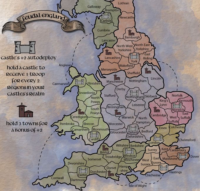
Special Features:Castles receive +2 autodeploy and validate a +1 bonus for every 2 regions in a bonus area.
What Makes This Map Worthy of Being Made: Because it has a unique style of gameplay that lends itself very well to this time and place, as well as depicting a classic period in English history.


The Basics:

You receive a +2 autodeploy on every Castle you hold.

For every 2 regular territories you hold in a kingdom (dark outlines) along with at least 1 castle you receive +1

To be determined:
Should players start randomly while Castle are protected by neutrals?

or
Should players start on the Castles and have to expand to the surrounding farmland that'll be neutral?

Should this be supersized?
(I know that the mods are really trying to limit the amount of supersized maps, however I think this will be best as a really big one. This is currently at 630x600 and as you can see the text especially borders on unreadable.)
Re: Midievil England

PostPosted: Thu May 24, 2012 9:41 am
by The Bison King
Click image to enlarge.
image

Re: Midievil England

PostPosted: Thu May 24, 2012 10:39 am
by koontz1973
Why not chop everything of upwards from south of Bolton, but try to keep York. Then you have a more square map to play with. As is, England being long and thin does not make for a good map. Another way would be to pick a part of England and make that. This idea almost shouts Sherwood Forest to me so why not just Nottingham and its surrounding counties.

Re: Midievil England

PostPosted: Thu May 24, 2012 11:59 am
by The Bison King
koontz1973 wrote:Why not chop everything of upwards from south of Bolton, but try to keep York. Then you have a more square map to play with. As is, England being long and thin does not make for a good map. Another way would be to pick a part of England and make that. This idea almost shouts Sherwood Forest to me so why not just Nottingham and its surrounding counties.

Cause I want to do the whole thing!

Click image to enlarge.
image

Ignore Scotland, I know it looks weird right now but most of that will be off the edge of the finished map.

Re: Midievil England

PostPosted: Thu May 24, 2012 12:51 pm
by koontz1973
What year is this, as depending on this, you may need to include it.

Re: Midievil England

PostPosted: Thu May 24, 2012 1:07 pm
by The Bison King
koontz1973 wrote:What year is this, as depending on this, you may need to include it.

No specific year. Circa 600-1200

Re: Midievil England

PostPosted: Fri May 25, 2012 12:20 am
by The Bison King
Click image to enlarge.
image

Re: Midievil England

PostPosted: Fri May 25, 2012 1:32 am
by koontz1973
Nice. But you will find that some of those counties did not exist at that time. So merging some would make the smaller map easier to deal with also.

The castles seem random, have you placed them there for a reason? I ask this as with the auto deploys, some will be easier to capture than others. (London-Oxford 2 territs)(Cardiff-Caernarvon 4 territs)

Also, I know this is being discussed at the moment, but till it is sorted, I would plan this to be at the normal sizes. If and when the supersizes are dealt with, you can look at it again. ;)

Re: Midievil England

PostPosted: Fri May 25, 2012 6:07 am
by The Bison King
Nice. But you will find that some of those counties did not exist at that time. So merging some would make the smaller map easier to deal with also.

You're really missing the point that I want this to be a big map. Given the bonus structure I think that the more territories there are the better the games will be. I've also come to the realization that bigger... for the most part really just is better. Every map I've worked on ranges from small to medium. This time I want BIG.

As for the county names, you're right I'll probably need o change a lot of them, but I need someone who knows a lot more about English history than I do to chime in on that one.

The castles seem random, have you placed them there for a reason? I ask this as with the auto deploys, some will be easier to capture than others. (London-Oxford 2 territs)(Cardiff-Caernarvon 4 territs)

The castles are not random I actually took great care where I placed those. For starts I didn't put a castle any where where there wasn't a castle prior to the date 1300. I picked central spots that touch a lot of territories so that you'll be able to defend many regions with one castle, making them a strategic stronghold (you know, like a castle). The un-evenness in proximity is supposed to reflect the area's of greatest interest/population/importance. This is not Feudal War or Feudal Epic, where each region is identical and numbered. Un-evenness is good, it makes the game more interesting.

You'll also notice that according to the rules in regions that have 2 castles there's no reason why 2 players can't be reaping a bonus off of the same region. I think that'll be really cool.

Also, I know this is being discussed at the moment, but till it is sorted, I would plan this to be at the normal sizes. If and when the supersizes are dealt with, you can look at it again. ;)

Again I'm really hoping to do this supersized. I'll plan on doing this big unless I can't. I truly and honestly think this map will be better the bigger it is. Shrinking it will be my damage control plan.

Re: Midievil England

PostPosted: Fri May 25, 2012 8:22 am
by Sniper08
i think its spelt medieval Bison :) and on the map its england and wales territories in play.

do players start with the castles or will they be neutral? if they start with castles may i suggest a losing condition that if you lose a castle your gone.

i gameplay will be interesting but straight away i can see that the bottem right will be the focus area all you have to do is hold surrey london and that long unamed territory and you'll get a big bonus for very few territories defended.

Re: Midievil England

PostPosted: Fri May 25, 2012 8:33 am
by Industrial Helix
Medievil -> Medieval

nice creative spelling though.

Re: Midievil England

PostPosted: Fri May 25, 2012 3:28 pm
by The Bison King
Industrial Helix wrote:Medievil -> Medieval

nice creative spelling though.

Oh damn... I'm stupid.

and on the map its england and wales territories in play.

Yeah but who wants to play on a map named Midieval England and Wales.

do players start with the castles or will they be neutral? if they start with castles may i suggest a losing condition that if you lose a castle your gone.

See I don't know that's still up for debate. I see merits to both.

i gameplay will be interesting but straight away i can see that the bottem right will be the focus area all you have to do is hold surrey london and that long unamed territory and you'll get a big bonus for very few territories defended.

Eh, not quite, check at the bottom, the Isle of Wight allows you a way to attack in at the bottom as well, and if need be I can add a similar connection on the other side.

Re: Midieval England

PostPosted: Fri May 25, 2012 10:31 pm
by Oneyed
nice idea, I like it.

you can not have map from 600 to 1200. better say you can, but in 600 it was Anglo-Saxon England, in 1200 it was Norman England. there were much differences - in 600 there were no castles, there were another counties and land dividing.

also Wales was totaly independent and different country to the time when Normans annexed it to England.

I advise to go with Norman England around 1200. why? there were castles as you present them, you can find more informations and also because Wales...

I can help you with some things, but much depends on how much you can change gameplay or bonuses, which time period you will choose, how close to reality you can be...

Oneyed

Re: Midieval England

PostPosted: Fri May 25, 2012 11:36 pm
by army of nobunaga
england again?> lol


try idaho next

Re: Midieval England

PostPosted: Fri May 25, 2012 11:39 pm
by army of nobunaga
hey I know dude, you should do a European map.

Re: Midieval England

PostPosted: Sat May 26, 2012 2:12 am
by koontz1973
Oneyed wrote: in 600 there were no castles, there were another counties and land dividing.

also Wales was totaly independent and different country to the time when Normans annexed it to England.


ImageBAMBURGH CASTLE
Castles like this have been built since the 3rd century. As the years go on, they got larger and more complex so yes, in the 6th century, they has castles like the ones depicted.

Wales was not a completely independent country. It never really has been.

Re: Midieval England

PostPosted: Sat May 26, 2012 5:56 am
by Oneyed
koontz1973 wrote:ImageBAMBURGH CASTLE
Castles like this have been built since the 3rd century. As the years go on, they got larger and more complex so yes, in the 6th century, they has castles like the ones depicted.


your picture is "new" Bamburgh castle based on Normans castle. there were some fortifications build on hills but mainly from wood and with look as motley and bailey.

Anglo Saxons did not build castles. only Alfred the Great started build fortifications known as burhs. and they were more walled towns as castles. also there were very few stone fortifications.
koontz1973 wrote:Wales was not a completely independent country. It never really has been.


no? and who ruled it after Romans left Britan?

Oneyed

Re: Midieval England

PostPosted: Sat May 26, 2012 6:08 am
by koontz1973
Oneyed wrote:
koontz1973 wrote:ImageBAMBURGH CASTLE
Castles like this have been built since the 3rd century. As the years go on, they got larger and more complex so yes, in the 6th century, they has castles like the ones depicted.


your picture is "new" Bamburgh castle based on Normans castle. there were some fortifications build on hills but mainly from wood and with look as motley and bailey.

Anglo Saxons did not build castles. only Alfred the Great started build fortifications known as burhs. and they were more walled towns as castles. also there were very few stone fortifications.
koontz1973 wrote:Wales was not a completely independent country. It never really has been.


no? and who ruled it after Romans left Britan?

Oneyed

Castles or walled fortifications have been around a lot earlier than this. The image produced is OK. There was no distinction between the two until around a 1000AD. The only part of the United Kingdom that has ever been independent of England is Scotland.

Re: Midieval England

PostPosted: Sat May 26, 2012 6:43 am
by Oneyed
koontz1973 wrote:The image produced is OK. There was no distinction between the two until around a 1000AD.


the image is modern castle. not one from before 1000 AD.
koontz1973 wrote:The only part of the United Kingdom that has ever been independent of England is Scotland.


about what you talk here? United Kingdom? this is map of medieval England and Wales was independent long time.

Oneyed

Re: Midieval England

PostPosted: Sat May 26, 2012 6:56 am
by koontz1973
No it was not. Wales has never been completely independent. Never has, never will be unless we get another stupid government like we had under Blair and Brown.

Wall fortifications have been around for thousands of years with turrets and battlements as well. The image is fine.

Re: Midieval England

PostPosted: Sat May 26, 2012 7:28 am
by Oneyed
koontz1973 wrote:No it was not. Wales has never been completely independent. Never has, never will be unless we get another stupid government like we had under Blair and Brown.


then you know very few about Welsh history... because when you say Wales was not completely independent who ruled it after Romans? I ask you second time...
koontz1973 wrote:Wall fortifications have been around for thousands of years with turrets and battlements as well. The image is fine.


again and again - this image is modern Bamburgh, build by Normans and then sveral times enlarged and rebuild for centuries...

Oneyed

Re: Midieval England

PostPosted: Sat May 26, 2012 7:45 am
by koontz1973
Oneyed wrote:
koontz1973 wrote:No it was not. Wales has never been completely independent. Never has, never will be unless we get another stupid government like we had under Blair and Brown.


then you know very few about Welsh history... because when you say Wales was not completely independent who ruled it after Romans? I ask you second time...
koontz1973 wrote:Wall fortifications have been around for thousands of years with turrets and battlements as well. The image is fine.


again and again - this image is modern Bamburgh, build by Normans and then sveral times enlarged and rebuild for centuries...

Oneyed

I probably know more about Welsh history than you as I am British. After the Romans left, the whole of England was ruled by many different kings know as petty kingdoms. Wales did not get a king of its own till after 1000AD. He was the offspring of two of the houses that ruled over parts of what is now Wales, known as the dark ages. It carried on like this till the 10th century when it was all unified into the Kingdom of England. That is the end of that discussion.

Here is a 6th century castle. End of that one as well.
Image

Now lets get this back onto the map please Oneyed but more than happy to continue your history lesson of my country via PM.

Re: Midieval England

PostPosted: Sat May 26, 2012 7:54 am
by Oneyed
koontz1973 wrote:I probably know more about Welsh history than you as I am British. After the Romans left, the whole of England was ruled by many different kings know as petty kingdoms. Wales did not get a king of its own till after 1000AD. He was the offspring of two of the houses that ruled over parts of what is now Wales, known as the dark ages. It carried on like this till the 10th century when it was all unified into the Kingdom of England. That is the end of that discussion.


it looks that you missed difference between independent and united. Wales was not united, but it was independent - the petty kingdoms in Wales were brithonic, so no one other ruled Wales, just Welsh... this is better end of discussion ;)
koontz1973 wrote:Here is a 6th century castle. End of that one as well.
Image


also you can see difference between this image and the first one posted by you.

Oneyed

Re: Midieval England

PostPosted: Sat May 26, 2012 10:41 am
by The Bison King
Interesting very interesting. From what I've been reading it sounds like the stone castle as we know it evolved from wood fortifications some time around 1000-1100 AD. Many fortifications that had been around for hundreds of years were modified and transformed into stone castles.

Whether or not Wales was an independent kingdom is really un-important to this the map. The important part is that it was Wales.

Oneyed wrote:nice idea, I like it.

you can not have map from 600 to 1200. better say you can, but in 600 it was Anglo-Saxon England, in 1200 it was Norman England. there were much differences - in 600 there were no castles, there were another counties and land dividing.

also Wales was totaly independent and different country to the time when Normans annexed it to England.

I advise to go with Norman England around 1200. why? there were castles as you present them, you can find more informations and also because Wales...

I can help you with some things, but much depends on how much you can change gameplay or bonuses, which time period you will choose, how close to reality you can be...

Oneyed


For the most part I think you have the right of it here. I would definitely appreciate your help, and for starters I'll share what's been my primary piece of reference and inspiration for this map.

Click image to enlarge.
image

This is a page from Joan Bleaus's Atlas Maior of 1665, The Greatest and Finest Atlas ever Published. Obviously the map is from 1665 but the description of the map states:

Joan Bleau wrote:This map shows the division of England into the seven kingdoms of Kent, Sussex, Wessex, Essex, Nurthumberland, East Anglia, and Mercia, the so called heptarchy.

This is where I puled the bonus divisions from. All the names I just pulled from pretty obvious sources, and I did a bit of research on the castles.

Re: Midieval England

PostPosted: Sat May 26, 2012 11:07 am
by koontz1973
The Bison King wrote:
Click image to enlarge.
image

This is a page from Joan Bleaus's Atlas Maior of 1665, The Greatest and Finest Atlas ever Published. Obviously the map is from 1665 but the description of the map states:

Joan Bleau wrote:This map shows the division of England into the seven kingdoms of Kent, Sussex, Wessex, Essex, Nurthumberland, East Anglia, and Mercia, the so called heptarchy.

This is where I puled the bonus divisions from. All the names I just pulled from pretty obvious sources, and I did a bit of research on the castles.


And not a Wales anywhere in site. :lol:

Sorry to of taken the thread over TBK, Oneyed and myself have carried on via PM. ;)