Moderator: Cartographers
koontz1973 wrote:Why not chop everything of upwards from south of Bolton, but try to keep York. Then you have a more square map to play with. As is, England being long and thin does not make for a good map. Another way would be to pick a part of England and make that. This idea almost shouts Sherwood Forest to me so why not just Nottingham and its surrounding counties.
koontz1973 wrote:What year is this, as depending on this, you may need to include it.
Nice. But you will find that some of those counties did not exist at that time. So merging some would make the smaller map easier to deal with also.
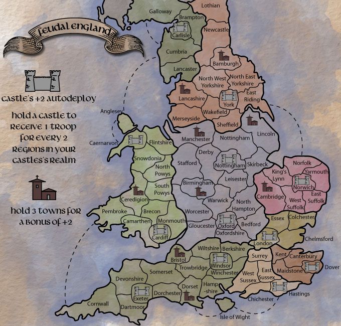
The castles seem random, have you placed them there for a reason? I ask this as with the auto deploys, some will be easier to capture than others. (London-Oxford 2 territs)(Cardiff-Caernarvon 4 territs)
Also, I know this is being discussed at the moment, but till it is sorted, I would plan this to be at the normal sizes. If and when the supersizes are dealt with, you can look at it again.
Industrial Helix wrote:Medievil -> Medieval
nice creative spelling though.
and on the map its england and wales territories in play.
do players start with the castles or will they be neutral? if they start with castles may i suggest a losing condition that if you lose a castle your gone.
i gameplay will be interesting but straight away i can see that the bottem right will be the focus area all you have to do is hold surrey london and that long unamed territory and you'll get a big bonus for very few territories defended.
Oneyed wrote: in 600 there were no castles, there were another counties and land dividing.
also Wales was totaly independent and different country to the time when Normans annexed it to England.
koontz1973 wrote:BAMBURGH CASTLE
Castles like this have been built since the 3rd century. As the years go on, they got larger and more complex so yes, in the 6th century, they has castles like the ones depicted.
koontz1973 wrote:Wales was not a completely independent country. It never really has been.
Oneyed wrote:koontz1973 wrote:BAMBURGH CASTLE
Castles like this have been built since the 3rd century. As the years go on, they got larger and more complex so yes, in the 6th century, they has castles like the ones depicted.
your picture is "new" Bamburgh castle based on Normans castle. there were some fortifications build on hills but mainly from wood and with look as motley and bailey.
Anglo Saxons did not build castles. only Alfred the Great started build fortifications known as burhs. and they were more walled towns as castles. also there were very few stone fortifications.koontz1973 wrote:Wales was not a completely independent country. It never really has been.
no? and who ruled it after Romans left Britan?
Oneyed
koontz1973 wrote:The image produced is OK. There was no distinction between the two until around a 1000AD.
koontz1973 wrote:The only part of the United Kingdom that has ever been independent of England is Scotland.
koontz1973 wrote:No it was not. Wales has never been completely independent. Never has, never will be unless we get another stupid government like we had under Blair and Brown.
koontz1973 wrote:Wall fortifications have been around for thousands of years with turrets and battlements as well. The image is fine.
Oneyed wrote:koontz1973 wrote:No it was not. Wales has never been completely independent. Never has, never will be unless we get another stupid government like we had under Blair and Brown.
then you know very few about Welsh history... because when you say Wales was not completely independent who ruled it after Romans? I ask you second time...koontz1973 wrote:Wall fortifications have been around for thousands of years with turrets and battlements as well. The image is fine.
again and again - this image is modern Bamburgh, build by Normans and then sveral times enlarged and rebuild for centuries...
Oneyed
koontz1973 wrote:I probably know more about Welsh history than you as I am British. After the Romans left, the whole of England was ruled by many different kings know as petty kingdoms. Wales did not get a king of its own till after 1000AD. He was the offspring of two of the houses that ruled over parts of what is now Wales, known as the dark ages. It carried on like this till the 10th century when it was all unified into the Kingdom of England. That is the end of that discussion.
koontz1973 wrote:Here is a 6th century castle. End of that one as well.
Oneyed wrote:nice idea, I like it.
you can not have map from 600 to 1200. better say you can, but in 600 it was Anglo-Saxon England, in 1200 it was Norman England. there were much differences - in 600 there were no castles, there were another counties and land dividing.
also Wales was totaly independent and different country to the time when Normans annexed it to England.
I advise to go with Norman England around 1200. why? there were castles as you present them, you can find more informations and also because Wales...
I can help you with some things, but much depends on how much you can change gameplay or bonuses, which time period you will choose, how close to reality you can be...
Oneyed
Joan Bleau wrote:This map shows the division of England into the seven kingdoms of Kent, Sussex, Wessex, Essex, Nurthumberland, East Anglia, and Mercia, the so called heptarchy.
The Bison King wrote:
This is a page from Joan Bleaus's Atlas Maior of 1665, The Greatest and Finest Atlas ever Published. Obviously the map is from 1665 but the description of the map states:Joan Bleau wrote:This map shows the division of England into the seven kingdoms of Kent, Sussex, Wessex, Essex, Nurthumberland, East Anglia, and Mercia, the so called heptarchy.
This is where I puled the bonus divisions from. All the names I just pulled from pretty obvious sources, and I did a bit of research on the castles.
Users browsing this forum: No registered users