[Abandoned] - New Zealand
Moderator: Cartographers
Re: New Zealand Map (Concept N - p1 & p5 )
![]() by reggie_mac on Wed Sep 24, 2008 2:19 pm
by reggie_mac on Wed Sep 24, 2008 2:19 pm
I'd have to say that i feel the same as milner94 about that one, i have a couple of ideas to take up some of the space and add some new territories, but by rotating it we will be hitting that same problem as the Brazil revamp.
Soviet Invaders: Space Invaders, it's not just a game
New Zealand Map - Foundry
"You can please all of the people some of the time, or some of the people all of the time, but not all of the people all of the time"
New Zealand Map - Foundry
"You can please all of the people some of the time, or some of the people all of the time, but not all of the people all of the time"
-

 reggie_mac
- Posts: 299
- Joined: Fri Nov 30, 2007 4:06 pm
- Location: Queenstown, NZ


Re: New Zealand Map (Concept N - p1 & p5 )
![]() by Ethitts on Wed Sep 24, 2008 10:05 pm
by Ethitts on Wed Sep 24, 2008 10:05 pm
Being from New Zealand I vote that the map does not get tilted, it would just look weird.


-

Ethitts
- Posts: 220
- Joined: Tue Jul 03, 2007 3:53 am


Re: New Zealand Map (Concept N - p1 & p5 )
![]() by e_i_pi on Wed Sep 24, 2008 10:25 pm
by e_i_pi on Wed Sep 24, 2008 10:25 pm
The continent that makes up the tip of the north island is very powerful, given the port. It can be held with one province, and can break 3 provinces within 2 steps. Just noting this, not sure if it should impact on the bonuses you've settled on, just thought I'd put it out there 
-

e_i_pi
- Posts: 1775
- Joined: Tue Feb 12, 2008 2:19 pm
- Location: Corruption Capital of the world


Re: New Zealand Map (Concept N - p1 & p5 )
![]() by t.e.c on Fri Sep 26, 2008 12:14 am
by t.e.c on Fri Sep 26, 2008 12:14 am
Kaitai should be Kaitaia. other than that it looks good.
-
t.e.c
- Posts: 298
- Joined: Sat Dec 09, 2006 10:55 am
- Location: aichi, japan


Re: New Zealand Map (Concept N - p1 & p5 )
![]() by reggie_mac on Fri Sep 26, 2008 1:57 am
by reggie_mac on Fri Sep 26, 2008 1:57 am
t.e.c wrote:Kaitai should be Kaitaia. other than that it looks good.
Fixed for next update, chur chur
Soviet Invaders: Space Invaders, it's not just a game
New Zealand Map - Foundry
"You can please all of the people some of the time, or some of the people all of the time, but not all of the people all of the time"
New Zealand Map - Foundry
"You can please all of the people some of the time, or some of the people all of the time, but not all of the people all of the time"
-
reggie_mac
- Posts: 299
- Joined: Fri Nov 30, 2007 4:06 pm
- Location: Queenstown, NZ
Re: New Zealand Map (Concept N - p1 & p5 )
![]() by reggie_mac on Sun Sep 28, 2008 4:20 am
by reggie_mac on Sun Sep 28, 2008 4:20 am
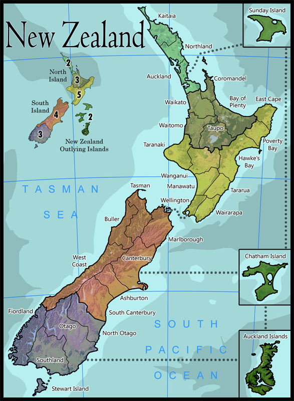
Concept O
Please note this is only a scale version of the working document for gameplay purposes.
http://farm4.static.flickr.com/3146/2894821002_b071831563_o.jpg
Ok, i know it needs work on the borders, and alot of other stuff, but for now im trying to get the feeling for the addition of the islands. As you can also see, the over all theme i'm going to try an end up with would be something like from an atlas ... you know, how you found out where somewhere was before google.
Last edited by reggie_mac on Fri Oct 03, 2008 8:49 pm, edited 1 time in total.
Soviet Invaders: Space Invaders, it's not just a game
New Zealand Map - Foundry
"You can please all of the people some of the time, or some of the people all of the time, but not all of the people all of the time"
New Zealand Map - Foundry
"You can please all of the people some of the time, or some of the people all of the time, but not all of the people all of the time"
-
reggie_mac
- Posts: 299
- Joined: Fri Nov 30, 2007 4:06 pm
- Location: Queenstown, NZ
Re: New Zealand Map (Concept N - p1 & p5 )
![]() by milner94 on Sun Sep 28, 2008 4:25 am
by milner94 on Sun Sep 28, 2008 4:25 am
Not sure about the islands. They're not actually that close to New Zealand, are they?
-
milner94
- Posts: 71
- Joined: Mon Jul 21, 2008 3:03 pm
Re: New Zealand Map (Concept N - p1 & p5 )
![]() by reggie_mac on Sun Sep 28, 2008 4:29 am
by reggie_mac on Sun Sep 28, 2008 4:29 am
Not really, but they are 'New Zealand', just thought i'd throw it out there.
Soviet Invaders: Space Invaders, it's not just a game
New Zealand Map - Foundry
"You can please all of the people some of the time, or some of the people all of the time, but not all of the people all of the time"
New Zealand Map - Foundry
"You can please all of the people some of the time, or some of the people all of the time, but not all of the people all of the time"
-
reggie_mac
- Posts: 299
- Joined: Fri Nov 30, 2007 4:06 pm
- Location: Queenstown, NZ
Re: New Zealand Map (Concept N - p1 & p5 )
![]() by MrBenn on Sun Sep 28, 2008 3:56 pm
by MrBenn on Sun Sep 28, 2008 3:56 pm
It looks like this map is heading in the right direction, and reggie_mac is responding positively to feedback.
Keep up this attitude and it shouldn't be long before you get moved into the foundry... [Advanced Draft]
Keep up this attitude and it shouldn't be long before you get moved into the foundry... [Advanced Draft]

PB: 2661 | He's blue... If he were green he would die | No mod would be stupid enough to do that
-

MrBenn
- Posts: 6880
- Joined: Wed Nov 21, 2007 9:32 am
- Location: Off Duty


Re: New Zealand Map (Concept N - p1 & p5 )
![]() by gho on Mon Sep 29, 2008 1:30 am
by gho on Mon Sep 29, 2008 1:30 am
great, those islands really add to the gameplay. The only thing id change is the Aukland-Sunday Island Border to a Northland or Kaitaia border to make the light blue continent worth the 2. Also i figure its not final, but you have to do something about the minimap, especially the extremely large islands you have there.
-
gho
- Posts: 129
- Joined: Thu Jun 05, 2008 7:13 am

Re: New Zealand Map (Concept N - p1 & p5 )
![]() by reggie_mac on Mon Sep 29, 2008 1:46 am
by reggie_mac on Mon Sep 29, 2008 1:46 am
That's a big 10-4. Im just trying to see if people think it would open up the game play enough to hope fully get this map through the process, It seems everyone else who previously tried it ran into the problem that the game play was a po-dunk, so hopefully this will add into it. Of course there are more islands i may be able to add in if needed.
I'd also like to leave the sunday island-auckland link as it is, for 2 reasons. 1. Its a more realistic link, and it makes that area the like Australasia on Classic, but as per normal this is subject to change depending on feed back.
I'd also like to leave the sunday island-auckland link as it is, for 2 reasons. 1. Its a more realistic link, and it makes that area the like Australasia on Classic, but as per normal this is subject to change depending on feed back.
Soviet Invaders: Space Invaders, it's not just a game
New Zealand Map - Foundry
"You can please all of the people some of the time, or some of the people all of the time, but not all of the people all of the time"
New Zealand Map - Foundry
"You can please all of the people some of the time, or some of the people all of the time, but not all of the people all of the time"
-
reggie_mac
- Posts: 299
- Joined: Fri Nov 30, 2007 4:06 pm
- Location: Queenstown, NZ
Re: New Zealand Map (Concept N - p1 & p6 )
![]() by milner94 on Mon Sep 29, 2008 10:33 am
by milner94 on Mon Sep 29, 2008 10:33 am
I'm afraid I personally don't like the islands. I just think it's a lot cleaner without them. Maybe, you could have the previous map (pre-islands), but insert two new sea routes. Firstly, from Auckland to Coramandel - only a short route across the little bay. Secondly, you do a route from Northland across to Great Barrier Island and down to Coromandel. Great Barrier Island would not be a territory, just a sensible stopping point for an invasion force. You would then get rid of the new islands, but you wouldn't need them. When you think about it, Blue continent has three borders to defend, and with the changes I suggested Aqua would have two. And from there you would have to capture the Dark Green, which wouldn't be particularly easy. And even if we don't implement this in the end, could you maybe just draft it up?
-
milner94
- Posts: 71
- Joined: Mon Jul 21, 2008 3:03 pm
Re: New Zealand Map (Concept N - p1 & p6 )
![]() by InkL0sed on Mon Sep 29, 2008 8:16 pm
by InkL0sed on Mon Sep 29, 2008 8:16 pm
I really like the islands for game play reasons, they make it much more circular. And you deal with them very nicely.
-

InkL0sed
- Posts: 2370
- Joined: Sat Jun 23, 2007 4:06 pm
- Location: underwater

Re: New Zealand Map (Concept N - p1 & p6 )
![]() by benny profane on Mon Sep 29, 2008 9:02 pm
by benny profane on Mon Sep 29, 2008 9:02 pm
Holy balls, this looks so much better than when I last saw it (which was quite a while ago).
Kudos on the graphic direction.
Some thoughts:
-Definitely keep the islands. I think 32 is a better territory number than 29.
-I would make the islands a +3, and the northernmost continent a +1.
-Chatham and Auckland islands should be the same dark green as Sunday island.
-The mini map colors are relics from old versions...you should consider changing them to better reflect the actual map (plus their brightness is kind of an eyesore).
-Do these continents have names of their own?
-(I'm nitpicking here)-You could probably find a more atlas-y font for the title (territory font is good). It's those lower case a's that seem less professional. (Like I said, this is almost a non-issue, so don't stress over it).
Otherwise, good work!
-

benny profane
- Posts: 248
- Joined: Sat Jun 16, 2007 4:00 pm
- Location: Brooklyn, NY

Re: New Zealand Map (Concept N - p1 & p6 )
![]() by DAT_WAT_SHE_SAID on Tue Sep 30, 2008 2:15 am
by DAT_WAT_SHE_SAID on Tue Sep 30, 2008 2:15 am
hope u make it soon, it looks great!!GO NEW ZEALAND!!
-

DAT_WAT_SHE_SAID
- Posts: 151
- Joined: Sat Mar 22, 2008 5:34 pm
- Location: London


Re: New Zealand Map (Concept N - p1 & p6 )
![]() by foregone on Tue Sep 30, 2008 2:44 am
by foregone on Tue Sep 30, 2008 2:44 am
Although I must dislike New Zealand on principle (RSA...and we did appalingly in the Trinations) this map looks great. 
I like the islands, think you should definitely keep them. Makes the gameplay considerably more interesting.
As mentioned earlier, the minimap needs an update, doesn't fit in at all at the moment. On that note, the title doesn't seem quite right either. Maybe a diferent font/placement. And if you want to make it an atlas theme you could perhaps use any open space to provide geographical info or somesuch. Population, area, etc.
Again, map looks excellent.
-

foregone
- Posts: 289
- Joined: Sun May 11, 2008 1:00 am
- Location: Sydney, NSW, Australia
Re: New Zealand Map (Concept N - p1 & p6 )
![]() by MrBenn on Tue Sep 30, 2008 10:05 am
by MrBenn on Tue Sep 30, 2008 10:05 am
1. On an admin side, you may need to start using version numbers rather than letters
2. I'm not sure that you need the North arrow, especially as you have long/lat lines on the map, and that the direction of North varies slightly
3 I'm not convinced by the orange border around the inset maps, and I have no idea about the scale of them (not that it's overly important ) I'd be inclined to use simpler inset boxes with a 1 or 2 pixel stroke... Have you considered using a minimap similar to gimils one on the British Isles revamp? There's plenty of space for additional detail like that...
4. I'm still wary about the map height, but can't think of a simple solution, apart from adding in some rotation or using a different projection.
5. Do the inset islands connect to each other? ie Does Auckland Isle connect to Chatham Isle? I'm assuming they don't, although am not very certain??
6. I'm not a fan of the bottleneck at the north of the island, as it favours Kaitai on the drop, and makes the +2 for 3 terrs very unbalanced. If you were to move the Sunday Island route from Auckland to Northland it would open up the bottleneck; either that, or reducing the bonus to a +1 would help
2. I'm not sure that you need the North arrow, especially as you have long/lat lines on the map, and that the direction of North varies slightly
3 I'm not convinced by the orange border around the inset maps, and I have no idea about the scale of them (not that it's overly important
4. I'm still wary about the map height, but can't think of a simple solution, apart from adding in some rotation or using a different projection.
5. Do the inset islands connect to each other? ie Does Auckland Isle connect to Chatham Isle? I'm assuming they don't, although am not very certain??
6. I'm not a fan of the bottleneck at the north of the island, as it favours Kaitai on the drop, and makes the +2 for 3 terrs very unbalanced. If you were to move the Sunday Island route from Auckland to Northland it would open up the bottleneck; either that, or reducing the bonus to a +1 would help
PB: 2661 | He's blue... If he were green he would die | No mod would be stupid enough to do that
-
MrBenn
- Posts: 6880
- Joined: Wed Nov 21, 2007 9:32 am
- Location: Off Duty
Re: New Zealand Map (Concept N - p1 & p6 )
![]() by mibi on Tue Sep 30, 2008 10:23 am
by mibi on Tue Sep 30, 2008 10:23 am
the minimap colors are too jarring and not in lnie with the rest of the map. I would also like to see more new zealand flavor, whatever that is.
-

mibi
- Posts: 3350
- Joined: Thu Mar 01, 2007 8:19 pm
- Location: The Great State of Vermont


Re: New Zealand Map (Concept N - p1 & p6 )
![]() by yeti_c on Wed Oct 01, 2008 4:01 pm
by yeti_c on Wed Oct 01, 2008 4:01 pm
Is this thing still in Drafts - it looks good enough to play on if you ask me!?!?
C.
C.

Highest score : 2297
-

yeti_c
- Posts: 9624
- Joined: Thu Jan 04, 2007 9:02 am


Re: New Zealand Map (Concept N - p1 & p6 )
![]() by reggie_mac on Wed Oct 01, 2008 4:37 pm
by reggie_mac on Wed Oct 01, 2008 4:37 pm
I'm afraid I personally don't like the islands. I just think it's a lot cleaner without them. Maybe, you could have the previous map (pre-islands), but insert two new sea routes. Firstly, from Auckland to Coramandel - only a short route across the little bay. Secondly, you do a route from Northland across to Great Barrier Island and down to Coromandel. Great Barrier Island would not be a territory, just a sensible stopping point for an invasion force. You would then get rid of the new islands, but you wouldn't need them. When you think about it, Blue continent has three borders to defend, and with the changes I suggested Aqua would have two. And from there you would have to capture the Dark Green, which wouldn't be particularly easy. And even if we don't implement this in the end, could you maybe just draft it up?
Personally i'd like to not have the islands either, but i think they need to stay.
-Definitely keep the islands. I think 32 is a better territory number than 29.
I have to agree here.
-I would make the islands a +3, and the northernmost continent a +1.
I'll be running a propers bonus calculator at some point, these are just made up numbers
-Chatham and Auckland islands should be the same dark green as Sunday island.
Yeah, the problem here is a used a digital elevation model and rendered it myself for the main part, but i couln't find much for the islands, they still need some work.
The mini map colors are relics from old versions...you should consider changing them to better reflect the actual map (plus their brightness is kind of an eyesore).
Working on it
Do these continents have names of their own?
There is probably some name for them, but im yet to find out, i will put it in when i do though, don't worry.
You could probably find a more atlas-y font for the title (territory font is good). It's those lower case a's that seem less professional. (Like I said, this is almost a non-issue, so don't stress over it).
Yup, but i made the changes the uploaded it, realised i had no title so i just chucked that one on.
. And if you want to make it an atlas theme you could perhaps use any open space to provide geographical info or somesuch. Population, area, etc.
Funnily enough, i have this info on another layer already, i sort of started with that when i did the re-draw but i've left it out for now. It will more than like;y be included int he future.
On an admin side, you may need to start using version numbers rather than letters
Concepts get letters, when it moves from Drafts and its actual idea stamp then it gets numbers. why, because if i can't prove the idea is valid within 25 concepts then i don't think i will ever prove it.
I'm not sure that you need the North arrow, especially as you have long/lat lines on the map, and that the direction of North varies slightly
Its an atlas, its gotta have a North arrow... maybe
I'm not convinced by the orange border around the inset maps, and I have no idea about the scale of them (not that it's overly important
I used the orange border because it was the ugliest colour i could find at the time and i wanted it to stand out like dogs balls, its ok, i hate it too but at the time it seemed like a fun thing to do. Inset boxes for islands will change. Will have a look at British isles re-vamp (sorry to gimil in advance for plagiarism)
I'm still wary about the map height, but can't think of a simple solution, apart from adding in some rotation or using a different projection.
I've already given my thoughts on this issue in page 1, and the reasoning behind it.
Postby reggie_mac on Wed Aug 27, 2008 9:26 pm
This is the large version of the map, not the small one, and it fits into the size restrictions for a Map
1. SMALL MAP: WIDTH up to 630 px; HEIGHT 600 px
2. LARGE MAP: WIDTH up to 840 px ; HEIGHT 800 px.
3. SIZE DIFFERENTIAL: A large map must be noticably larger than their small map; 9% larger is required but 33.3% (1/3rd) is recommended.
4. NOTE: Mapmakers are encouraged to make their large maps smaller than the maximum size limits when possible to eliminate scrolling to attack/read the sidebar info.
Scrolling isn't ideal, but like web design you have to make a call for the screen res you are creating it for. Heres some quick stats.
Resolution vs. % of Internet Users
Higher than 1024×768 = 38%
1024×768 = 48%
800×600 = 8%
Lower than 800×600 = < 1%
Unknown = 6%
So as we can see 80%+ of people use a screen res of 1024x768 or higher, which is pretty much the new standard for 4:3 monitors, i plan on having the small map fit nicely into this size. However a lot of people these days get wide screen monitors which have are generally in the 1200x800 mark. The display size of higher than 1024x768 is up 12% for 2008 on last year so going by these trends we can expect around 50% plus people to be using the SXGA (1280 x 1024) by mid next year, so really im future proofing my map. I know scrolling is not ideal, but NZ is a tall long country and if i make it too much smaller then half of the territories wouldn't fit the armies on them.
so yeah. I have to scroll on some maps too, I pretty much just play the small versions.
5. Do the inset islands connect to each other? ie Does Auckland Isle connect to Chatham Isle? I'm assuming they don't, although am not very certain??
Will be fixed as part of sorting out the borders, and yes is the answer, they do connect.
I'm not a fan of the bottleneck at the north of the island, as it favours Kaitai on the drop, and makes the +2 for 3 terrs very unbalanced. If you were to move the Sunday Island route from Auckland to Northland it would open up the bottleneck; either that, or reducing the bonus to a +1 would help
Again, bonuses calculated later once i have the territory numbers sorted.
the minimap colors are too jarring and not in lnie with the rest of the map. I would also like to see more new zealand flavor, whatever that is
Minimap under development. NZ flavor .. i have a few ideas that will be added in later, once again i need to get the territory numbers a bit more locked down first so i know how much space i have. But what ever i do it will be very subtle, kind of like fine cooking, less is more if you know what i mean.
Is this thing still in Drafts - it looks good enough to play on if you ask me!?!?
C.
Even i don't think its ready yet...that orange is f#&king ugly... although i could probably knock the XML out in a couple of hours and we'd be away laughing.
On another note, once this is done i will make the nice big 300DPI version available so people can print and play IRL (which is what i'm doing to test gameplay)
Soviet Invaders: Space Invaders, it's not just a game
New Zealand Map - Foundry
"You can please all of the people some of the time, or some of the people all of the time, but not all of the people all of the time"
New Zealand Map - Foundry
"You can please all of the people some of the time, or some of the people all of the time, but not all of the people all of the time"
-
reggie_mac
- Posts: 299
- Joined: Fri Nov 30, 2007 4:06 pm
- Location: Queenstown, NZ
Re: New Zealand Map (Concept N - p1 & p6 )
![]() by MrBenn on Fri Oct 03, 2008 7:37 am
by MrBenn on Fri Oct 03, 2008 7:37 am
I'm looking forward to seeing your next draft...
PB: 2661 | He's blue... If he were green he would die | No mod would be stupid enough to do that
-
MrBenn
- Posts: 6880
- Joined: Wed Nov 21, 2007 9:32 am
- Location: Off Duty
Re: New Zealand Map (Concept P - p1 & p7 )
![]() by reggie_mac on Fri Oct 03, 2008 8:57 pm
by reggie_mac on Fri Oct 03, 2008 8:57 pm
Concept P
Like most concepts this image is only a re-size of the working document.
Info For This Post:
New bonus region called 'New Zealand Outlaying Islands' - because thats what they are called
Link between Chatham and Auckland Islands put in
Level colours of outlaying islands so now look the same
Islands made a bit smaller. because i wanted too.
Minimap complete re-draw
North indicator removed (your right Mr Benn i don't need it)
Oceans re-drawn around islands so they are now accurate
Changed Title Text
F@#king horrible orange border removed, The new border is so thick for a reason, to be reveled at a later date.
I think some people may have some 'issues' with the amount of unused space, I've tried to put to fill it out as much as i can, but it just doesn't look right. New Zealand is a small island nation tucked down in the bottom of the south pacific ocean, if i try to add to much more in around the map i think it will just detract from the over all image. Maybe its a kiwi think, i mean we are used to looking at maps of NZ and seeing a whole bunch of nothing around us. Look in any major Atlas, its the same, we are pretty lucky if we get more than 2 pages. This is something i feel pretty strongly about so its not likely to change, and I believe most other kiwis would agree with me on this one.
Getting there .......
Like most concepts this image is only a re-size of the working document.
- Click image to enlarge.
Info For This Post:
New bonus region called 'New Zealand Outlaying Islands' - because thats what they are called
Link between Chatham and Auckland Islands put in
Level colours of outlaying islands so now look the same
Islands made a bit smaller. because i wanted too.
Minimap complete re-draw
North indicator removed (your right Mr Benn i don't need it)
Oceans re-drawn around islands so they are now accurate
Changed Title Text
F@#king horrible orange border removed, The new border is so thick for a reason, to be reveled at a later date.
I think some people may have some 'issues' with the amount of unused space, I've tried to put to fill it out as much as i can, but it just doesn't look right. New Zealand is a small island nation tucked down in the bottom of the south pacific ocean, if i try to add to much more in around the map i think it will just detract from the over all image. Maybe its a kiwi think, i mean we are used to looking at maps of NZ and seeing a whole bunch of nothing around us. Look in any major Atlas, its the same, we are pretty lucky if we get more than 2 pages. This is something i feel pretty strongly about so its not likely to change, and I believe most other kiwis would agree with me on this one.
Getting there .......
Soviet Invaders: Space Invaders, it's not just a game
New Zealand Map - Foundry
"You can please all of the people some of the time, or some of the people all of the time, but not all of the people all of the time"
New Zealand Map - Foundry
"You can please all of the people some of the time, or some of the people all of the time, but not all of the people all of the time"
-
reggie_mac
- Posts: 299
- Joined: Fri Nov 30, 2007 4:06 pm
- Location: Queenstown, NZ
Re: New Zealand Map (Concept P - p1 & p7 )
![]() by DAT_WAT_SHE_SAID on Sat Oct 04, 2008 1:31 am
by DAT_WAT_SHE_SAID on Sat Oct 04, 2008 1:31 am
I reckon you should cut the islands out of it and just have ports going from auckland-wellington-christchurch or something.
The islands make it look ugly, if u want to keep them, atleast could u make them a bit smaller please?the boxes are massive!
Other then that, keep it up i want to play this map already haha
The islands make it look ugly, if u want to keep them, atleast could u make them a bit smaller please?the boxes are massive!
Other then that, keep it up i want to play this map already haha
-
DAT_WAT_SHE_SAID
- Posts: 151
- Joined: Sat Mar 22, 2008 5:34 pm
- Location: London
Re: New Zealand Map (Concept P - p1 & p7 )
![]() by reggie_mac on Sat Oct 04, 2008 2:32 am
by reggie_mac on Sat Oct 04, 2008 2:32 am
DAT_WAT_SHE_SAID wrote:I reckon you should cut the islands out of it and just have ports going from auckland-wellington-christchurch or something.
The islands make it look ugly, if u want to keep them, atleast could u make them a bit smaller please?the boxes are massive!
Other then that, keep it up i want to play this map already haha
Tried that, didn't work.
If i make the islands too much smaller its not going to work either.
just noticed i need to fix up the Auckland Island ocean.
Soviet Invaders: Space Invaders, it's not just a game
New Zealand Map - Foundry
"You can please all of the people some of the time, or some of the people all of the time, but not all of the people all of the time"
New Zealand Map - Foundry
"You can please all of the people some of the time, or some of the people all of the time, but not all of the people all of the time"
-
reggie_mac
- Posts: 299
- Joined: Fri Nov 30, 2007 4:06 pm
- Location: Queenstown, NZ
Who is online
Users browsing this forum: No registered users
|
|||||||
| Conquer Club is not associated with RISK online in any way. Copyright © 2006-2025 by Big Wham LLC | |||||||