MichelSableheart wrote:Cool idea, great theming, and good to see some activity in the Map Foundry again!
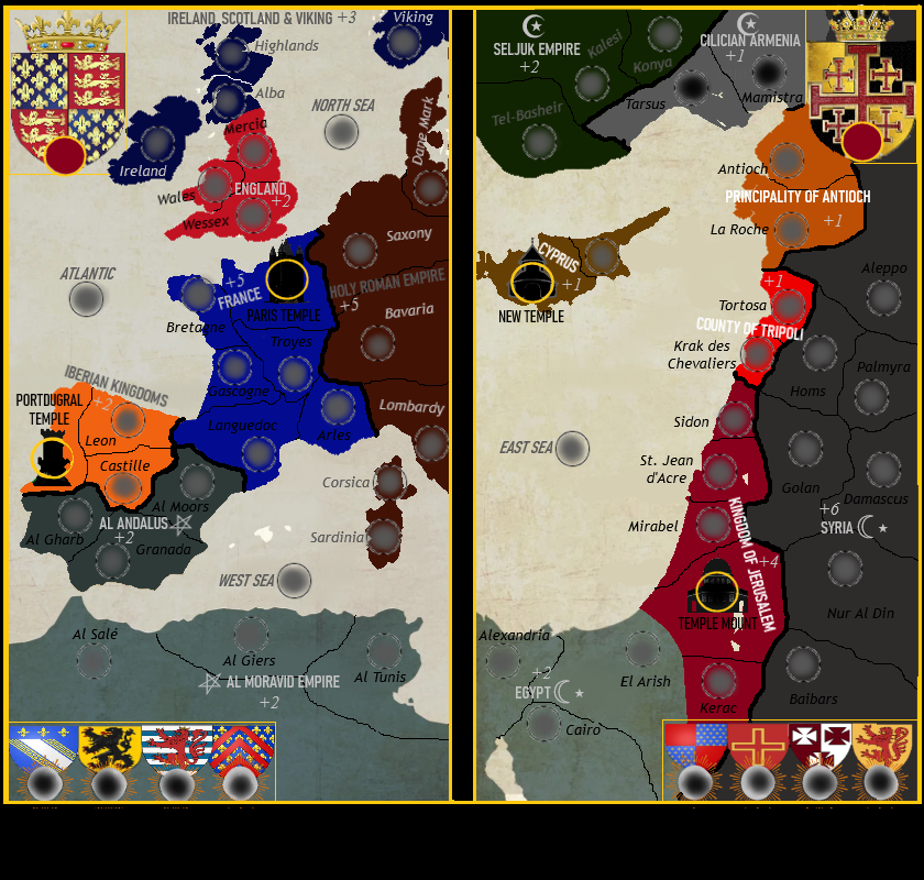
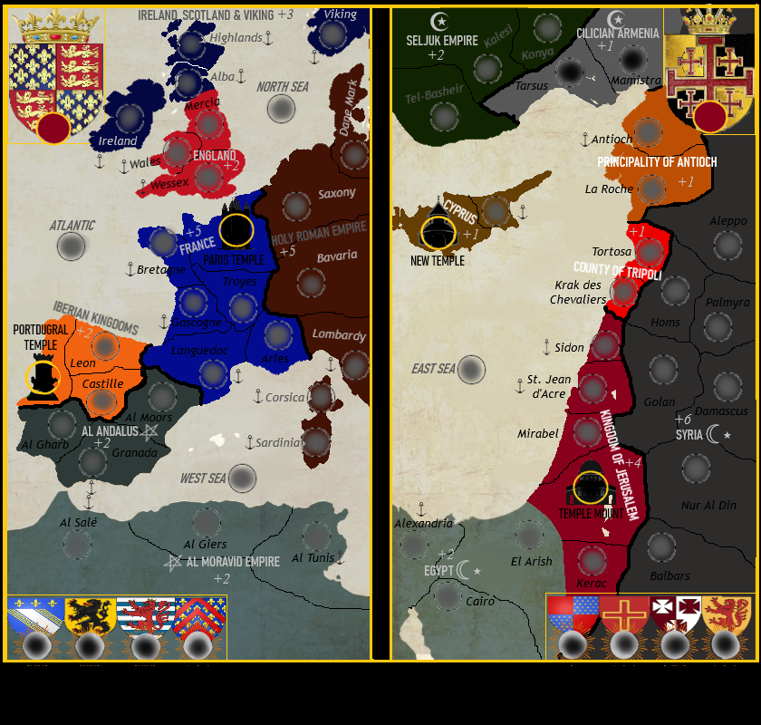
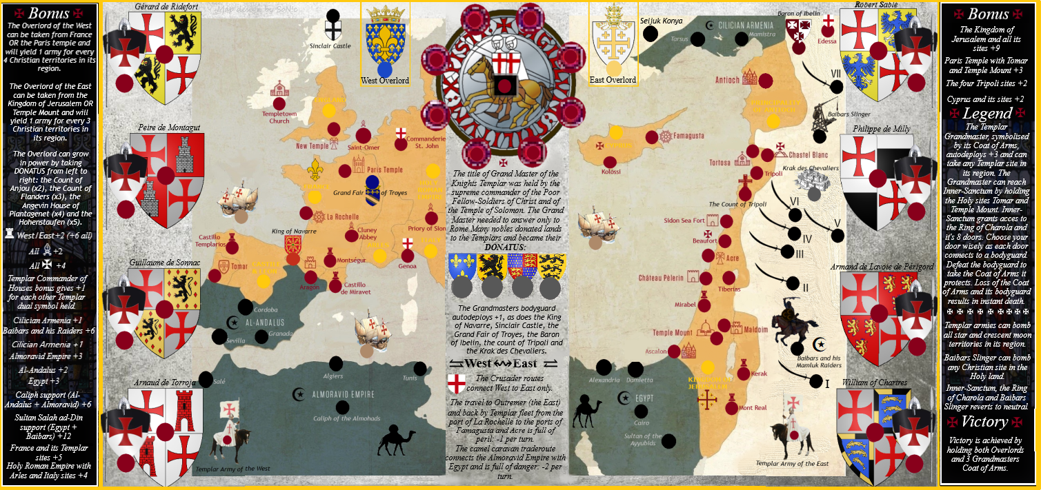
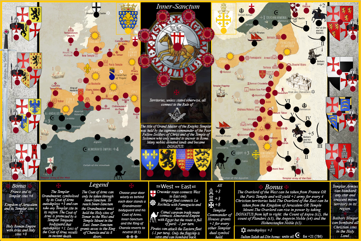
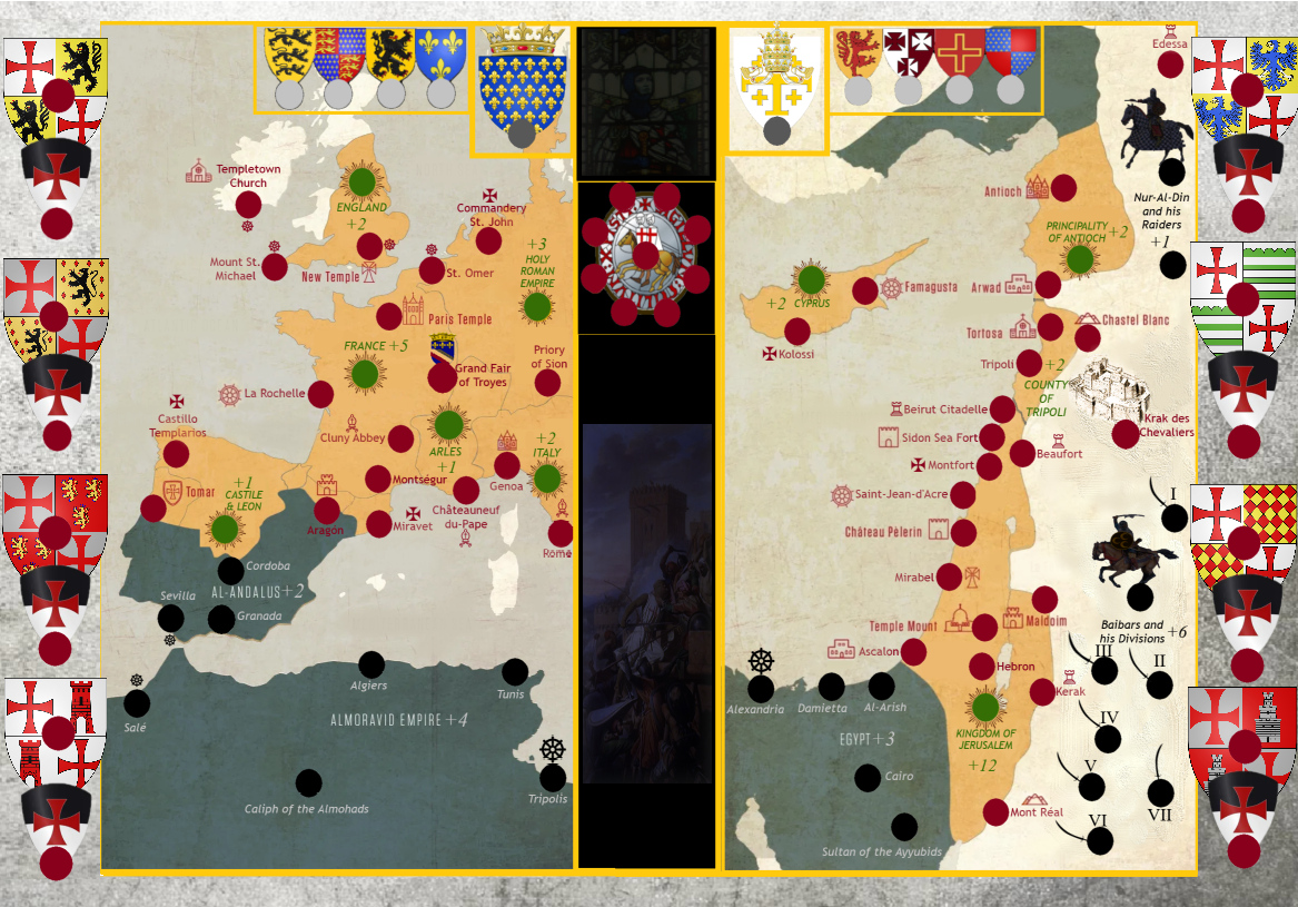
Overall, it feels like you might be trying to throw in a few too many ideas, hurting the clarity of the map. Are the caravan routes part of Almoravid or Egypt respectively? Why do Navarre, Troyes and Tripoli have different colors? Are there special meanings behind the symbols next to Jaffa, Hebron, Temple mount? Which templar is behind which door of the inner sanctum? Do countries count as territories for blocking connections, or can rome attack Genoa? Can you attack over water? If you can't attack over water, how do you reach the Almoravid Empire? If you can attack over water, can Alexandria attack Mamistra, and why? Can Genoa and the Commandery of St. John attack each other? Which territories are considered part of the holy land? From where can you take the Templar Armies? These are all questions I currently wouldn't be able to answer you from merely looking at the map.
I don't know to what extend the supersize policy (
https://www.conquerclub.com/forum/viewtopic.php?f=10&t=182136) is still valid. If that policy is still valid, then even as a supersize map, it would need a small version of 780 by 650 pixels, and map width is currently at the maximum. Standard size limits would be 840 by 800 pixels for the large map, and 630 by 600 for the small version.
A final note: white on a yellow background is very difficult to read.
Thx for feedback!
"it feels like you might be trying to throw in a few too many ideas, hurting the clarity of the map"
As mentioned in the 4.0 post this version (4.0) is "way too packed" indeed - somethings have to go but the question is what exactly
"Are the caravan routes part of Almoravid or Egypt respectively?"
- great feedback! - your right, thats confusing so they will have to be redone in another color (not a part of Egypt/Almoravid)
Why do Navarre, Troyes and Tripoli have different colors?
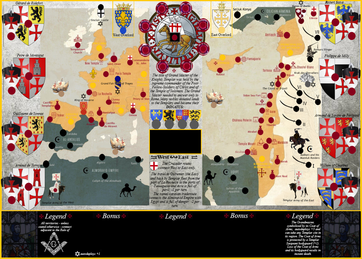
because these are autodeploy terrs - they have the star of david symbol next to them and the red colored dots are the Templar sites (to be taken from the Grandmaster) so the Grandmaster can't take these autodeploys (that would be too easy) - they have to be won "from the ground"hence they have to be in a different color
But perhaps the solution is to get rid of these autodeploys terrs?
"Are there special meanings behind the symbols next to Jaffa, Hebron, Temple mount?"
YES, as stated in the legend "Commander of Houses bonus" grants +1 for every "dual templar symbol". So there are a lot of "dual terrs" (with the same symbol only to appear twice on the map)
for example Jaffa and Arwad, Hebron and Antioch, Aragon and Mont Real...if you hold two "dual symbols" you get +1(if a symbol appears for example 3 times on the map it is not a "dual symbol")
Also Temple Mount has a unique symbol as it is so important to hold (as gateway to objectives/win), so is Tomar and the Paris Temple (the only 3 with a unique symbol)
"Which templar is behind which door of the inner sanctum?"
As stated in the legend you "
have to choose your door wisely" - its Grandmasters afterall

- but the solution is real simple: left upper corner of the charola ring goes to left upper grandmaster bodyguard, right bottom corner goes to...well you have it
"Do countries count as territories for blocking connections, or can rome attack Genoa?" the legend says "adjacent to the rule of.. the freemason logo ("The Square and Compasses" symbol) so Rome should be able to attack Genoa - but perhaps too complicated so the solution is perhaps a redesign of the map with "classic territories borders" instead of the Compass (drawing tool) - its just that logo is so important in freemasonry and with the templar connection i wanted to incorporate that
"Can you attack over water? If you can't attack over water, how do you reach the Almoravid Empire?"
, NO you cant (except small ports terrs - symbolised by the small boat’s wheel - can reach the adjacent port that has a small boats wheel logo aswell - like Templetown Church in Ireland and Mount St Michael in England
So the map needs these symbols on Almoravid empire at least (or another solution) - and stated in the legend- GREAT FEEDBACK!! thanks for noticing that error!
"Can Genoa and the Commandery of St. John attack each other?
" No they are not adjacent to the rule of the Compass logo/ (drawing tool)
"Which territories are considered part of the holy land?"
You have to know your history for this one..otherwise you'll learn it by playing.. - "the holy land" and what it includes is a known fact afterall (like the "USA")- so Cyprus for example is not a part of the Holy Land
"From where can you take the Templar Armies?"
The legend says that the Grandmaster can get any templar site in its region and the templar army is included as templar site (basically "templar sites" = all the red dots) But i get you because the 4 "Donatus" terrs are not supposed to have a red dot. Needs to be changed like it was in the 3.0 version.
A final note: white on a yellow background is very difficult to read.
Again GREAT feedback, will have to be changed then!
the supersize policy
- also great feedback, but we live in 2023.. people have wide screens these days, and in any case 630 by 600 pixels would mean bye bye - then lets stop making new maps and wait till the last players turns off the lights of CC
Think about it: "630 by 600 pixels" in 2023?
you have to move with the times!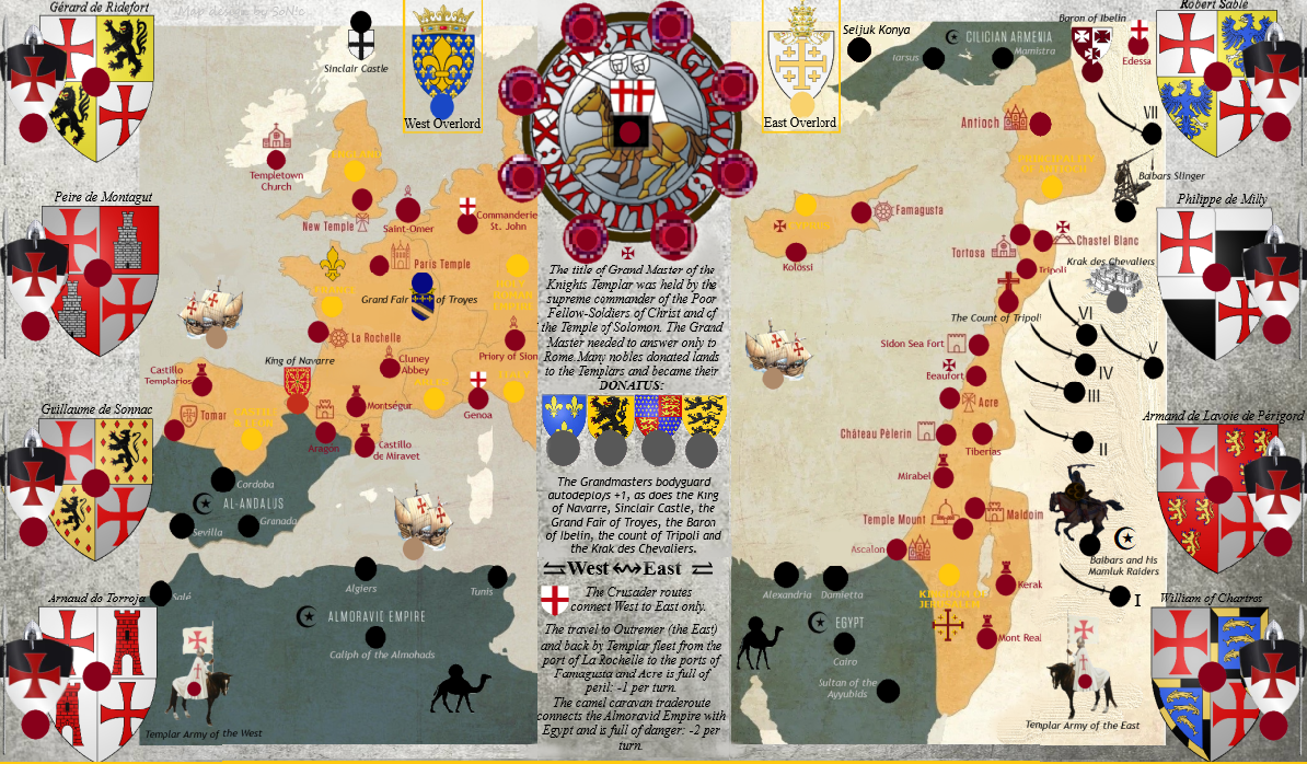 [/url]
 [/url]


 [/url]