Conquer Club

Métro Parisien v.17

This is where maps get made. Check out what's in development and give us some feedback.

Moderator: Cartographers

Forum rules
Please read the Community Guidelines before posting.

Métro Parisien v.17

Postby waauw on Tue May 05, 2015 2:23 pm

Image

Map Name: "Métro Parisien"
Mapmaker(s): waauw & GeneralFault
Number of Territories: 60
Special Features: unusual but simple gameplay(overlapping bonuses, autodeploys, territory bonus), similar to North-west passage and the rail-maps
What Makes This Map Worthy of Being Made: Paris is a city of marvels. World renowned touristic attractions and a famous subway system. As no other, this city can not and should not be hidden away from CC. So hereby, la ville lumière, la ville des amoureux, Paris la ville des merveilles.(the city of light, the city of lovers, Paris the city of marvels)
Map Image:
big version(830x780):
Click image to enlarge.
image

small version(630x551):
Click image to enlarge.
image

show: old


show: starting positions and bonuses


show: bonuses

show: gameplay


Copyright Agreement:
The author retains copyright on their work, and gives Conquer Club permission to use the imagery free of charge, for as long as Conquer Club sees fit on the Conquer Club website. Conquer Club cannot sell, lease, or lend the right to use the images to anyone else. The author swears that their map is their own work, or a legal derivative work and by submitting it, do hereby claim all responsibility for that being true.
Attachments
Metro Parisien.xml
(24.52 KiB) Downloaded 1146 times
Last edited by waauw on Sat Jun 13, 2015 9:05 am, edited 26 times in total.
User avatar
Lieutenant waauw
 
Posts: 4756
Joined: Fri Mar 13, 2009 1:46 pm

Re: Les routes de Paris

Postby betiko on Tue May 05, 2015 2:39 pm

you need a route between st lazare and moulin rouge otherwise I can't get home waauw.

also technically, you should call it "les rue de Paris". "route" in french means roads, but not really in an urban environment way.
Image
User avatar
Major betiko
 
Posts: 10941
Joined: Fri Feb 25, 2011 3:05 pm
Location: location, location
22

Re: Les routes de Paris

Postby waauw on Tue May 05, 2015 2:56 pm

betiko wrote:you need a route between st lazare and moulin rouge otherwise I can't get home waauw.

also technically, you should call it "les rue de Paris". "route" in french means roads, but not really in an urban environment way.


Really? I thought you were from somewhere in the Provence considering you cheer for l'OM.
User avatar
Lieutenant waauw
 
Posts: 4756
Joined: Fri Mar 13, 2009 1:46 pm

Re: Les routes de Paris

Postby betiko on Tue May 05, 2015 3:06 pm

waauw wrote:
betiko wrote:you need a route between st lazare and moulin rouge otherwise I can't get home waauw.

also technically, you should call it "les rue de Paris". "route" in french means roads, but not really in an urban environment way.


Really? I thought you were from somewhere in the Provence considering you cheer for l'OM.


yeah I'm originally from Marseille but all the years I spent in France were in Paris. That's why I don't hate PSG as the large majority of OM fans do.
Image
User avatar
Major betiko
 
Posts: 10941
Joined: Fri Feb 25, 2011 3:05 pm
Location: location, location
22

Re: Les routes de Paris

Postby Dukasaur on Tue May 05, 2015 4:37 pm

Looks nice.

Instead of Paris roads I would do the subways, which are far more notable. The subways of Paris are groundbreaking. Along with London, New York, and Moscow, the Paris subway system is one of the most famous in the world. If you haven't invested too much time to turn back yet, I would do that.

Also, it's not true that nobody is interested in your WWI map. I'm interested, and I'm not nobody...:)

The foundry doesn't get much traffic, in any thread. Of the 12 people who visited the foundry in the last month, 2 posted about your WW I map, which is 18% of the total! Gotta keep these things in perspective.

Anyway, best wishes on Paris! Regardless of whether you accept my idea about the subways or not, it is a wonderful city, and your map has some nice vibrant bright colours, which I really like.
“‎Life is a shipwreck, but we must not forget to sing in the lifeboats.”
― Voltaire
User avatar
Sergeant 1st Class Dukasaur
Community Coordinator
 
Posts: 27745
Joined: Sat Nov 20, 2010 4:49 pm
Location: Beautiful Niagara
32

Re: Les routes de Paris

Postby waauw on Tue May 05, 2015 5:26 pm

Dukasaur wrote:Looks nice.

Instead of Paris roads I would do the subways, which are far more notable. The subways of Paris are groundbreaking. Along with London, New York, and Moscow, the Paris subway system is one of the most famous in the world. If you haven't invested too much time to turn back yet, I would do that.

Anyway, best wishes on Paris! Regardless of whether you accept my idea about the subways or not, it is a wonderful city, and your map has some nice vibrant bright colours, which I really like.


Yeah, I kept into mind people liked light colours for the WWI map, so I immediately started off with light colours on this map.

I also didn't know the paris subway system was that famous, but I like using roads for the following 2 reasons:
  • Paris has many famous boulevards and avenues, the most notable one being the 'Champs Élysées'.
  • Using the Périférique I don't have too many dead ends at the border of the map(except Roland Garros and La Défense which I found too important to leave out). The Périférique is circular and therefor creates a somewhat arena-like map.

Of course if there is good reasoning or a lot of supoprt for a subway system, I'll start drawing out a subway map.

Dukasaur wrote:Also, it's not true that nobody is interested in your WWI map. I'm interested, and I'm not nobody...:)

The foundry doesn't get much traffic, in any thread. Of the 12 people who visited the foundry in the last month, 2 posted about your WW I map, which is 18% of the total! Gotta keep these things in perspective.


You're probably right. Anyway, no harm done. Considering how slow maps pass through the foundry and how much time I've got on my hands, I can easily work on two maps simultaneously.
User avatar
Lieutenant waauw
 
Posts: 4756
Joined: Fri Mar 13, 2009 1:46 pm

Re: Les routes de Paris

Postby betiko on Tue May 05, 2015 6:58 pm

there's been at least two other parigian attempts:

viewtopic.php?f=583&t=207205

viewtopic.php?f=63&t=168212

I agree with Duka though: I think the parigian metro would make much more sense; you routes dont really correspond to anything...

But I think making the whole metro lines would be pretty impossible and they would need to be highly simplified. Personally I think it would be cool if the map had some graphics looking like an actual parisian metro map.

Image
Image
User avatar
Major betiko
 
Posts: 10941
Joined: Fri Feb 25, 2011 3:05 pm
Location: location, location
22

Re: Les routes de Paris

Postby jcmagno on Tue May 05, 2015 9:29 pm

waauw wrote:
Dukasaur wrote:Looks nice.

Instead of Paris roads I would do the subways, which are far more notable. The subways of Paris are groundbreaking. Along with London, New York, and Moscow, the Paris subway system is one of the most famous in the world. If you haven't invested too much time to turn back yet, I would do that.

Anyway, best wishes on Paris! Regardless of whether you accept my idea about the subways or not, it is a wonderful city, and your map has some nice vibrant bright colours, which I really like.


Yeah, I kept into mind people liked light colours for the WWI map, so I immediately started off with light colours on this map.

I also didn't know the paris subway system was that famous, but I like using roads for the following 2 reasons:
  • Paris has many famous boulevards and avenues, the most notable one being the 'Champs Élysées'.
  • Using the Périférique I don't have too many dead ends at the border of the map(except Roland Garros and La Défense which I found too important to leave out). The Périférique is circular and therefor creates a somewhat arena-like map.

Of course if there is good reasoning or a lot of supoprt for a subway system, I'll start drawing out a subway map.

Dukasaur wrote:Also, it's not true that nobody is interested in your WWI map. I'm interested, and I'm not nobody...:)

The foundry doesn't get much traffic, in any thread. Of the 12 people who visited the foundry in the last month, 2 posted about your WW I map, which is 18% of the total! Gotta keep these things in perspective.


You're probably right. Anyway, no harm done. Considering how slow maps pass through the foundry and how much time I've got on my hands, I can easily work on two maps simultaneously.


Didn't post nothing in the WWI map thread because atm is understandable... but concept looks good.

pd. i love L size maps.

jc.
General jcmagno
 
Posts: 114
Joined: Sun Oct 27, 2013 8:15 pm

Re: Les rues de Paris/le métro de Paris??

Postby waauw on Wed May 06, 2015 7:47 am

Okay, so upon request I tried to work the map out according to the Parisian subway-system. It isn't perfect, all the details aren't worked out but with this you should be able to grasp an idea of what it would look like. Tell me which you prefer.

Click image to enlarge.
image


Click image to enlarge.
image


Personally I still prefer the road system. Gameplay-wise it is much easier. Of course I could adapt the regional bonus to the subway-system too but because of the many more interconnections and overlappings, I think that map would still end up being infinitely more complex. the only thing helpful to the subway-map would be cutting out several more 'lignes', not sure which though(4 and 5 at least probably).

Both maps imitate real roads and subway lines but in both cases stations and roads got merged or slightly deviated to make sure it wasn't too messy.
User avatar
Lieutenant waauw
 
Posts: 4756
Joined: Fri Mar 13, 2009 1:46 pm

Re: Les rues de Paris/le métro de Paris??

Postby betiko on Wed May 06, 2015 8:08 am

I personally like way better what you just did waauw!
But I'm biaised as I'm parigian, maybe your first map was better in terms of game play, haven't given it enough thought.
You definitely need to put the RER B line in electric blue though, that red is totally the A line and it's confusing as hell for parigians!!! :lol:

also on top of line 13 (west extension) les courtilles???? where did you get that name from?? that station is Asnieres-Genevilliers.
I think you did a good job in simplifying the network by removing many stations and lines, otherwise it would've been unplayable.

for the title, I'd change it to "le métro Parisien" we wouldn't really say "le métro de Paris"
Image
User avatar
Major betiko
 
Posts: 10941
Joined: Fri Feb 25, 2011 3:05 pm
Location: location, location
22

Re: Les rues de Paris/le métro de Paris??

Postby waauw on Wed May 06, 2015 8:12 am

betiko wrote:I personally like way better what you just did waauw!
But I'm biaised as I'm parigian, maybe your first map was better in terms of game play, haven't given it enough thought.
You definitely need to put the RER B line in electric blue though, that red is totally the A line and it's confusing as hell for parigians!!! :lol:

also on top of line 13 (west extension) les courtilles???? where did you get that name from?? that station is Asnieres-Genevilliers.
I think you did a good job in simplifying the network by removing many stations and lines, otherwise it would've been unplayable.

for the title, I'd change it to "le métro Parisien" we wouldn't really say "le métro de Paris"


simplified it a bit by removing lines 3,4 and 5. Better?
I used same maps you :P I probably read something wrong,
As for the colour line 13, the blue was too resemblent to some other blue(don't know which line) so I had to change colour. If I change that back to blue, I'll probably change another blue line into red.

Image
User avatar
Lieutenant waauw
 
Posts: 4756
Joined: Fri Mar 13, 2009 1:46 pm

Re: Les rues de Paris/le métro de Paris??

Postby Dukasaur on Wed May 06, 2015 10:55 am

Nice!

Now, replace the square boxes with nice oval lozenges, and add back the pretty buildings from your first map.
“‎Life is a shipwreck, but we must not forget to sing in the lifeboats.”
― Voltaire
User avatar
Sergeant 1st Class Dukasaur
Community Coordinator
 
Posts: 27745
Joined: Sat Nov 20, 2010 4:49 pm
Location: Beautiful Niagara
32

Re: Les rues de Paris/le métro de Paris??

Postby betiko on Wed May 06, 2015 11:02 am

Hum, I think you did well by removing those 3 other lines, it's much clearer like this, and better in terms of game play imo.
The B line's original blue could look like the line 2 a bit too much... so even if you've taken the A line's original colour for the B, it does makes sense. A bit odd for parisians as we all associate a line with a colour, but this is meant for the general CC population, not for people who know Paris well.

In terms of design, I think it could be pretty cool to stick to the original paper map theme, maybe mith some lines shoowing it's unfolded or something.... This is what all Parisian tourists use:

Image

I think it could be cool to use those colours.

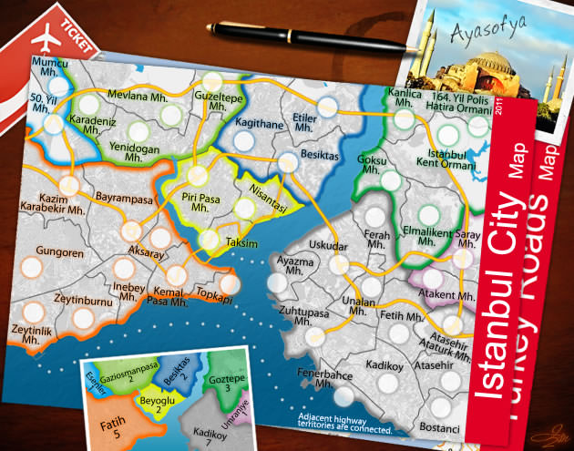
A real paper map theme like the istambul map is cool:

Image


Also, for the station design: I think it would look cool with a circle with the same colour than the line instead of your black squares. If a station is on several lines you could circle it with as many line colours. You would have inside a white circle where the troop amount could be inserted?

also, this is just for fun: the bunny telling you not to put your fingers on the door is a real classic everyone who has taken the parisian metro know... if at some point you have some unused space on the background, could be a funny filler:

Image

just a few thoughts for your inspiration mate!
Last edited by betiko on Wed May 06, 2015 11:07 am, edited 2 times in total.
Image
User avatar
Major betiko
 
Posts: 10941
Joined: Fri Feb 25, 2011 3:05 pm
Location: location, location
22

Re: Les rues de Paris/le métro de Paris??

Postby betiko on Wed May 06, 2015 11:04 am

Dukasaur wrote:Nice!

Now, replace the square boxes with nice oval lozenges, and add back the pretty buildings from your first map.


I wouldn't put the buildings, i think that esthetically it harms the map.
Image
User avatar
Major betiko
 
Posts: 10941
Joined: Fri Feb 25, 2011 3:05 pm
Location: location, location
22

Re: Les rues de Paris/le métro de Paris??

Postby waauw on Wed May 06, 2015 5:37 pm

betiko wrote:just a few thoughts for your inspiration mate!


How's this? Should be closer to what you wanted. Made it look like one of those subway maps hanging on the wall.

Click image to enlarge.
image


changes:
  • framework design changed as Betiko requested
  • change line B back to blue as Betiko requested
  • title design
  • added auto's
  • changed boxes into ovals as dukasaur requested
  • added touristic spots as dukasaur requested(doesn't really hurt the map imo)
  • added airport signs to Orly and CDG

to do:
  • is the current bonus-system effectif enough?
  • where to place neutrals?
  • decorations next to title
  • toy with background colours, see if I can find any better
  • create more depth between woodwork and map?
  • write the names of the various lines
  • ...
User avatar
Lieutenant waauw
 
Posts: 4756
Joined: Fri Mar 13, 2009 1:46 pm

Re: Métro Parisien

Postby betiko on Wed May 06, 2015 6:00 pm

i like it!
somehow, I think the green difference was much clearer between lines 6 and 9 in your previous version, did you change it?
line 7, with the new background might be a bit too light and you don't see it much out of paris, both colours are too similar, at least on my screen
+1 for 5 adjacent stations on the same line seems like an awfully hard bonus to hold. On austrum and vertex you only need 4 and you have some great combos that give you large bonuses. On route 66 with 3 adjacent on the route 66 you already get your +1.
Do you think both airports should link?

I'm wondering what kind of exclusive gameplay we should think of and if this shouldn't be turned into a conquest map with 1 starting position and neutrals along the line (neutral 2s maybe?) neutral 5s on the hub stations (at least 3 line hubs) with autodeploy?
Image
User avatar
Major betiko
 
Posts: 10941
Joined: Fri Feb 25, 2011 3:05 pm
Location: location, location
22

Re: Métro Parisien

Postby sempaispellcheck on Thu May 07, 2015 8:33 am

This is nice, waauw! Great work!
I like the idea of larger neutral stacks on the autodeploy regions.
You might want to do +2 or +3 per 5 stations on a line with an extra +1, +2, or +3 for holding the entire line (depending on length, number of connections, etc.)
You could also add an objective by connecting each landmark to a station - hold 5 for +2, hold all to win?

sempai
High score: 2200 - July 20, 2015
Game 13890915 - in which I helped clinch the NC4 title for LHDD

Image
User avatar
Lieutenant sempaispellcheck
 
Posts: 2852
Joined: Fri Sep 10, 2010 10:31 pm
Location: Among the clouds and the skyscrapers, saving the world.

Re: Métro Parisien

Postby waauw on Thu May 07, 2015 12:43 pm

Click image to enlarge.
image


changes:
  • added victory objectif
  • added bonuses(I'm scared that with so many crossings on this map a system of +1 per x sequential stations could create very lucky drops)
  • shortened names
  • added backgrounds to endstations for bonuses(bad idea, map looks disrupted and overly black, will probably remove it by next time)
  • changed colorus to help with visibility
  • removed touristic buildings again, Betiko might be right that it got too crowded
  • added paper background for map
  • added another layer of wood in attempt to provide more depth, attempt failed I think :|

@Betiko:
  • problem with singular starting positions is that due to the map lay-out some people will be too close to others and some too far away, the map is too asymetrical imo
  • I could do the airport thingie, however do airplanes even fly between Orly and CDG?

@sempai: I got rid of the landmarks, could still add 'm back of course, but how about this new objectif? pretty hard to accomplish but not undoable for a dominating player
User avatar
Lieutenant waauw
 
Posts: 4756
Joined: Fri Mar 13, 2009 1:46 pm

Re: Métro Parisien

Postby betiko on Thu May 07, 2015 1:10 pm

-well all the colours are perfectly easy to differenciate now.
-Yeah for me it's definitely better without the buildings, really unnecesairy for an underground map I think.
-I think you need to find some space to list lines and the corresponding bonuses, like you did on the first version. It's really confusing like this as you have to look for them everywhere, some vertical, some diagonal, some horizontal...
-there are some connections I don't understand. On line 7 is mairie d'ivry connected to place d'italie AND vla? same thing on line 13, I know normally the line splits in 2 on la fourche (my station) but on your map I guess you would want it to split on place de clichy and it's not very clear.
-regarding the objectives, it's hard to say, but it does look like holding 2 full lines is really hard and could be a viable objective
-regarding the airports, it has nothing to do with reality, obviously there are no flights between Orly and CDG, but on other maps such as chicago that I have in mind, the various airports do connect. Could be a good way to move around your stack... the problem is that it's the same line so I wonder if it would be useful or not. I'm just thinking that playing assassin on this map can be a freaking nightmare by the way! :lol:
Image
User avatar
Major betiko
 
Posts: 10941
Joined: Fri Feb 25, 2011 3:05 pm
Location: location, location
22

Re: Métro Parisien

Postby Dukasaur on Thu May 07, 2015 2:19 pm

I like it much better with the buildings.

First time I tourned Paris, in '77, I had a map exactly like that, a subway map with the buildings shown. When you're travelling underground, there's not much to see. It really helped to have a map with landmarks on it that helps to visualize what part of the city you're in.
“‎Life is a shipwreck, but we must not forget to sing in the lifeboats.”
― Voltaire
User avatar
Sergeant 1st Class Dukasaur
Community Coordinator
 
Posts: 27745
Joined: Sat Nov 20, 2010 4:49 pm
Location: Beautiful Niagara
32

Re: Métro Parisien

Postby betiko on Thu May 07, 2015 3:42 pm

Dukasaur wrote:I like it much better with the buildings.

First time I tourned Paris, in '77, I had a map exactly like that, a subway map with the buildings shown. When you're travelling underground, there's not much to see. It really helped to have a map with landmarks on it that helps to visualize what part of the city you're in.


Did life exist in colour back then? I think i heard colours were invented in 1979.

Just look at other city maps on cc: no landmarks. And no landmarks on metro maps for over 40 years i guess there is a reason.
Image
User avatar
Major betiko
 
Posts: 10941
Joined: Fri Feb 25, 2011 3:05 pm
Location: location, location
22

Re: Métro Parisien

Postby Dukasaur on Fri May 08, 2015 2:15 am

betiko wrote:
Dukasaur wrote:I like it much better with the buildings.

First time I tourned Paris, in '77, I had a map exactly like that, a subway map with the buildings shown. When you're travelling underground, there's not much to see. It really helped to have a map with landmarks on it that helps to visualize what part of the city you're in.


Did life exist in colour back then? I think i heard colours were invented in 1979.

Just look at other city maps on cc: no landmarks. And no landmarks on metro maps for over 40 years i guess there is a reason.

I don't know if you're being an idiot on purpose, but I'm in no mood for your deliberate argumentativeness.

There's landmarks on the Copenhagen map, there's landmarks on the Madrid map, there's one landmark on downtown Montreal and one landmark for Liberty Island on the New York map. There's pictograms reflecting local pubs and bike trails in Portland, and pictograms for military deployments in Berlin. There's pictures of landmarks in the margins of the San Francisco map, London, Port Moresby, Sydney, Chicago, London, Moscow, Jakarta, and Istanbul. Where are you finding these magical CC city maps that have no landmarks?

If your government is bankrupt and has decided to remove the pictures from tourist maps in order to save money on artists' wages, that's not my problem. Maybe you should pay your taxes on time. Most cities that I've been to, ever -- Rome, Prague, Bratislava, London, New York, Granada, Cordoba, Wien, Milan, I could go on forever -- there's not many cities in North America or Europe that I haven't been to -- do carry pictures of famous landmarks. It helps people visualize and what is in the various districts, because the names and numbers of the districts are basically meaningless to an outsider. Hell, even the sad, desolate shithole of Thunder Bay had a Board of Trade map with pictograms of allegedly "famous" buildings on it.
“‎Life is a shipwreck, but we must not forget to sing in the lifeboats.”
― Voltaire
User avatar
Sergeant 1st Class Dukasaur
Community Coordinator
 
Posts: 27745
Joined: Sat Nov 20, 2010 4:49 pm
Location: Beautiful Niagara
32

Re: Métro Parisien

Postby waauw on Fri May 08, 2015 10:21 am

Click image to enlarge.
image


changes:
  • added legend box
  • made circular icons for every line
  • re-added monuments(non-parisians might want know where everything is)
  • removed the unnecessary black boxes of course, but left 'm for the airports
  • made adjustments to ligne 7 and 13 to make connections more clear

@Betiko:VLA= Villejuif Louis Aragon
User avatar
Lieutenant waauw
 
Posts: 4756
Joined: Fri Mar 13, 2009 1:46 pm

Re: Métro Parisien

Postby betiko on Fri May 08, 2015 10:51 am

Dukasaur wrote:
betiko wrote:
Dukasaur wrote:I like it much better with the buildings.

First time I tourned Paris, in '77, I had a map exactly like that, a subway map with the buildings shown. When you're travelling underground, there's not much to see. It really helped to have a map with landmarks on it that helps to visualize what part of the city you're in.


Did life exist in colour back then? I think i heard colours were invented in 1979.

Just look at other city maps on cc: no landmarks. And no landmarks on metro maps for over 40 years i guess there is a reason.

I don't know if you're being an idiot on purpose, but I'm in no mood for your deliberate argumentativeness.

There's landmarks on the Copenhagen map, there's landmarks on the Madrid map, there's one landmark on downtown Montreal and one landmark for Liberty Island on the New York map. There's pictograms reflecting local pubs and bike trails in Portland, and pictograms for military deployments in Berlin. There's pictures of landmarks in the margins of the San Francisco map, London, Port Moresby, Sydney, Chicago, London, Moscow, Jakarta, and Istanbul. Where are you finding these magical CC city maps that have no landmarks?

If your government is bankrupt and has decided to remove the pictures from tourist maps in order to save money on artists' wages, that's not my problem. Maybe you should pay your taxes on time. Most cities that I've been to, ever -- Rome, Prague, Bratislava, London, New York, Granada, Cordoba, Wien, Milan, I could go on forever -- there's not many cities in North America or Europe that I haven't been to -- do carry pictures of famous landmarks. It helps people visualize and what is in the various districts, because the names and numbers of the districts are basically meaningless to an outsider. Hell, even the sad, desolate shithole of Thunder Bay had a Board of Trade map with pictograms of allegedly "famous" buildings on it.


no, I genuinely think that life in coulour was invented in 1979 duka, obviously. You should review your count on NA and european cities though, I think the figure is "a lot" and your count is "a few".

-to tell the truth I think waauw did well on his last version and I find the landmarks better integrated. It looked a bit ugly on previous versions.
-waauw were did you get the name of the stations from? Always seen that station labelled as "villejuif" only, but it's not too important I guess.
-you would spell "soyez prudents!" by the way as it's plural.
- think something would need to be done regarding the label/fonts used for the stations. I don't really know right now how you could make it look a bit nicer... it just looks like some times new roman unfinished stuff . i wonder iwhat it would look like if the map looked sticked to a metro door, with a metallic background instead (there is no wood in the metro tbh) or some white/turquoise green that are more in the theme and the actual colours used by the RATP, basically the colours from the logo in the corner...

You've clearly advanced this map at an incredible pace this week, well done.
Image
User avatar
Major betiko
 
Posts: 10941
Joined: Fri Feb 25, 2011 3:05 pm
Location: location, location
22

Re: Métro Parisien

Postby waauw on Fri May 08, 2015 11:02 am

betiko wrote:-to tell the truth I think waauw did well on his last version and I find the landmarks better integrated. It looked a bit ugly on previous versions.
-waauw were did you get the name of the stations from? Always seen that station labelled as "villejuif" only, but it's not too important I guess.
-you would spell "soyez prudents!" by the way as it's plural.
- think something would need to be done regarding the label/fonts used for the stations. I don't really know right now how you could make it look a bit nicer... it just looks like some times new roman unfinished stuff . i wonder iwhat it would look like if the map looked sticked to a metro door, with a metallic background instead (there is no wood in the metro tbh) or some white/turquoise green that are more in the theme and the actual colours used by the RATP, basically the colours from the logo in the corner...

You've clearly advanced this map at an incredible pace this week, well done.


-yeah, it looks better now because I limited most station names to initials
-I made the same mistake there as with Asnières-genevilliers. Check out the ends of the lines, they confuse me like hell.
https://eclipsisvintage.files.wordpress.com/2013/01/paris-metro-map-4.gif
-my father is going to kill me once he finds out what kind of french mistakes I make :oops:
-yeah was always going to change the font. Yesterday I tried size the map down to about 600x600(small map size) and the names weren't readable. But everything in its own due time.
-I could try the metallic green. But I haven't been able to find a picture of what those subway-map-boxes look like in Paris. So I had no clue what it looked like. I do like wood though. It gives off a warm colour and wood always has something fancy to it.
User avatar
Lieutenant waauw
 
Posts: 4756
Joined: Fri Mar 13, 2009 1:46 pm

Next

Return to Map Foundry

Who is online

Users browsing this forum: No registered users